This construction video motivated me to research this dam.
 |
| Pacific Northwest Hydroelectric Power Plant Operations posted Fort Gibson Dam Tony Embree: Good lord that’s a crap load load of spill gates. Tom Hamilton: Tony Embree I wonder if they've ever all been opened at the same time. Andy Michel: Tom Hamilton Yes they have from what I understand. But not fully open. |
 |
| Screenshot posted by Tulsa District, U.S. Army Corps of Engineers
HISTORY OF FORT GIBSON DAM
Purpose: Flood control and hydroelectric power.
Location: On the Grand (Neosho) River at river mile 7.7, in Mayes, Wagoner, and Cherokee Counties, about 5 miles north of Fort Gibson, Oklahoma, and about 12 miles northeast of Muskogee, Oklahoma.
History: Construction began in 1942, was suspended during World War II, and resumed in May 1946. Closure of the embankment was completed in June 1949. The project became fully operational when the last of four generators started producing commercial power in September 1953.
Fort Gibson Lake draws its name from the nearby historic town of Fort Gibson, Oklahoma. Fort Gibson played a prominent part in the military history of early-day Oklahoma. It was the scene of many important events – from the first appearance of the relocated members of the Five Civilized Tribes through its contacts with the tribes of the western plains and the turbulent years of the Civil War. Union and Confederate forces at different times occupied the post.
Founded in 1824 by Col. Matthew Arbuckle of the 7th Infantry and named for Col. George Gibson, this was the farthest west military outpost in the chain of fortifications stretching from the northern to the southern borders of the United States. Until 1857, it served as the chief military center for the Indian Territory and many treaties with the Indians were signed here. It was the base for the establishment of the subposts of Forts Chaffee, Wayne, Holmes, Arbuckle and Washita. Jefferson Davis, later president of the Confederacy, served here under Gen. Zachary Taylor, who became president of the United Sates in 1849. Washington Irving, accompanying an exploring expedition in 1832, started the trip from Fort Gibson which he described in his book, “A Tour On the Prairies.” It was also from Fort Gibson that George Catlin, renowned painter of the American Indian, set out with the First Infantry Dragoons on their expedition into the Kiowa and Comanche Country in 1834. The name of the first post office at the site, Cantonment Gibson, was changed to Fort Gibson in 1842.
Among the many famous Americans identified with Fort Gibson are Capt. Nathan Boone, A.P. Chouteau, Sam Houston, Gen. Henry Leavenworth, Robert E. Lee and John Howard Payne. Fort Gibson National Cemetery – the only national cemetery in Oklahoma – is located ½ mile east of the town of Fort Gibson.
The old Texas Road, with its traffic of cattlemen, freighters and traders, passed near the fort, but the main communication for the troops and residents of the surrounding country was by steamboat on the Arkansas River. French fur traders of the southwest made it a center for their business transactions, and supplies for a large area were imported and dispersed from this point.
Abandoned by the government in 1857, Fort Gibson was reoccupied during the Civil War. After the war, it continued as an agency, aiding in the civilization of the west, before it was fully abandoned in 1890. Today at the Fort Gibson, a reconstructed log stockade stands on the site of the first log fort. Now a National Historical Landmark, the stockade is owned by the state of Oklahoma and is open to the public year-round.
Other communities near the lake, with the dates their post offices were established include: Wagoner, 1888; Okay, a trading post as far back as 1822, had several names before it officially became Okay in 1919; Mazie, 1905; Chouteau, 1871; Murphy, 1912; and Hulbert, 1903.
Type of Structure: The dam includes two concrete, gravity, non-overflow sections. One section, 285 feet long, extends from the spillway to the earth embankment at the right abutment. The other section, 460 feet long, extends from the intake structure to the earth embankment at the left abutment. The dam also includes two earth embankment sections, one of which extends about 374 feet from the natural ground at the right abutment to the right bank concrete non-overflow section. The other embankment, 63 feet long, extends from the left abutment to the left bank concrete non-overflow section. The powerhouse intake structure is located adjacent to the spillway on the left and is 318 feet long. The total length of the structures, including the spillway, is 2,990 feet, and the maximum height above the streambed is 110 feet. Oklahoma State Highway 251A extends across the top of the structures. There are seven rolled earthfill dikes on the west side of the reservoir which have a total length of 21,678 feet.
Spillway & Outlet Works: The spillway section is a concrete, gravity, ogee weir which extends across the existing river channel and a major portion of the right bank floodplain. Spillway capacity is 986,000 cubic feet per second at the top of the flood control pool. The spillway is equipped with thirty 40- by 35-foot tainter gates operated by individual electric-motored hoists. The total length of the spillway is 1,490 feet. Outlet works consist of ten 5-foot, 8-inch by 7-foot rectangular sluices located through the spillway weir. Capacity of the outlet works varies from 21,000 cfs at the flood control pool elevation with no spillway discharge to 14,400 cfs at the flood control pool elevation with the spillway discharging at full capacity. Flows through the sluices are controlled by a means of hydraulically-operated, cast-iron slide gates. Emergency closure of the sluices can be accomplished using a bulkhead lowered by a hoist into frames provided at the sluice entrances. A 48-inch-diameter pipe is located through the right abutment of the dam for municipal water supply for the city of Muskogee. Bank-full capacity on the Grand (Neosho) River below the dam is about 100,000 cfs.
Hydrologic Data: Estimated peak discharge and volume for the flood of May 7 to June 1, 1943, (with Grand Lake O' the Cherokees in operation) were 400,000 cfs and 5,918,000 acre-feet, respectively. Total runoff from the drainage area above the dam site was 8.88 inches.
Authorization: Flood Control Act approved August 18, 1941; incorporated in the Arkansas River multipurpose plan by the River and Harbor Act of July 24, 1946; Project Document HD 107, 76th Congress, 1st Session; and the Water Resources Development Act of 1986, Public Law 99-662.
[USACE]
U.S. Army photo by Edward N. Johnson
USACE-Tulsa, Public Affairs |
 |
| USACE |
 |
| Jun 2017 Photo by Brandy Crosley |
I'm copying the entire contents of http://www.swt-wc.usace.army.mil/FGIB.lakepage.htmlhttp://www.swt-wc.usace.army.mil/FGIB.lakepage.html
because this data changes. And it is interesting that within 2 hours they increased the gate discharge by over 50%. When we visited Little Rock, AZ on Jan 4, 2018, it was a bright sunny day. But they talked about just having seven days of rain.
Current Readings:
- 0.68 ft ABOVE normal
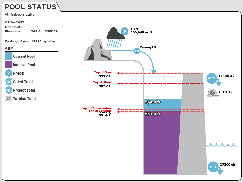
- Pool elevation is 554.68 feet on Monday 07Jan19 Time: 2100 hours.
- At this elevation the total amount of water stored in Ft. Gibson Lake is 378323 acre-feet.
- Reservoir release is 31872 cubic feet per second on Monday 07Jan19 Time: 2100 hours.
- Flood control pool is 1.43% full.
- Flood control pool storage filled is 13124 acre-feet which is equivalent to 0.02 inches of runoff over the entire drainage basin.
- Flood control pool storage empty is 906075 acre-feet which is equivalent to 1.36 inches of runoff over the entire drainage basin.
Current Gate Settings:
- Friday, 04 Jan 2019 17:00
- Pool Elevation = 559.75 ft
- Total Discharge = 41368 cubic feet per second.
- New Gate Settings:
- Tainter Gate 1 = 2.00 ft
- Tainter Gate 10 = 1.50 ft
- Tainter Gate 11 = 2.00 ft
- Tainter Gate 12 = 2.00 ft
- Tainter Gate 13 = 2.00 ft
- Tainter Gate 14 = 1.50 ft
- Tainter Gate 15 = 1.50 ft
- Tainter Gate 16 = 1.50 ft
- Tainter Gate 17 = 1.50 ft
- Tainter Gate 18 = 1.50 ft
- Tainter Gate 19 = 1.50 ft
- Tainter Gate 2 = 1.50 ft
- Tainter Gate 20 = 1.50 ft
- Tainter Gate 21 = 1.50 ft
- Tainter Gate 22 = 1.50 ft
- Tainter Gate 23 = 1.50 ft
- Tainter Gate 24 = 1.50 ft
- Tainter Gate 25 = 1.50 ft
- Tainter Gate 26 = 1.50 ft
- Tainter Gate 27 = 1.50 ft
- Tainter Gate 28 = 1.50 ft
- Tainter Gate 29 = 1.50 ft
- Tainter Gate 3 = 1.50 ft
- Tainter Gate 30 = 1.50 ft
- Tainter Gate 4 = 1.50 ft
- Tainter Gate 5 = 1.50 ft
- Tainter Gate 6 = 1.50 ft
- Tainter Gate 7 = 1.50 ft
- Tainter Gate 8 = 1.50 ft
- Tainter Gate 9 = 1.50 ft
- Friday, 04 Jan 2019 15:00
- Pool Elevation = 559.6 ft
- Total Discharge = 26690 cubic feet per second.
- New Gate Settings:
- Tainter Gate 1 = 0.50 ft
- Tainter Gate 10 = 1.00 ft
- Tainter Gate 11 = 0.50 ft
- Tainter Gate 12 = 0.50 ft
- Tainter Gate 13 = 0.50 ft
- Tainter Gate 14 = 0.50 ft
- Tainter Gate 15 = 0.50 ft
- Tainter Gate 16 = 0.50 ft
- Tainter Gate 17 = 0.50 ft
- Tainter Gate 18 = 0.50 ft
- Tainter Gate 19 = 0.50 ft
- Tainter Gate 2 = 0.50 ft
- Tainter Gate 20 = 0.50 ft
- Tainter Gate 21 = 0.50 ft
- Tainter Gate 22 = 1.00 ft
- Tainter Gate 23 = 1.00 ft
- Tainter Gate 24 = 1.00 ft
- Tainter Gate 25 = 1.00 ft
- Tainter Gate 26 = 1.00 ft
- Tainter Gate 27 = 1.00 ft
- Tainter Gate 28 = 1.00 ft
- Tainter Gate 29 = 1.00 ft
- Tainter Gate 3 = 1.00 ft
- Tainter Gate 30 = 1.00 ft
- Tainter Gate 4 = 1.00 ft
- Tainter Gate 5 = 1.00 ft
- Tainter Gate 6 = 1.00 ft
- Tainter Gate 7 = 1.00 ft
- Tainter Gate 8 = 1.00 ft
- Tainter Gate 9 = 1.00 ft

Reservoir Data:
| Elevation | Incremental Storage | Cumulative Storage | |||
|---|---|---|---|---|---|
| (feet) | (inches) | (acre-feet) | (inches) | (acre-feet) | |
| Surcharge Pool: | ---- | ---- | ---- | ---- | ---- |
| Flood Control Pool: | 582.00 | 1.38 | 919199 | 1.93 | 1284399 |
| Conservation Pool: | 554.00 | 0.08 | 53899 | 0.55 | 365199 |
| Inactive Pool: | 551.00 | 0.47 | 311300 | 0.47 | 311300 |
Streambed Elevation: 483.00 feet.
Top of Dam Elevation: 593.00 feet.
All storages based on a contributing drainage area of 12491 square miles or 666239 acre-feet
Longitude: -95° 13' 43" Latitude: 35° 52' 16"
Map of Ft. Gibson Lake Dam
Links for More Information:
Graphs of Measured and Calculated Lake Parameters:
Click on a graph to receive the full-size graphic.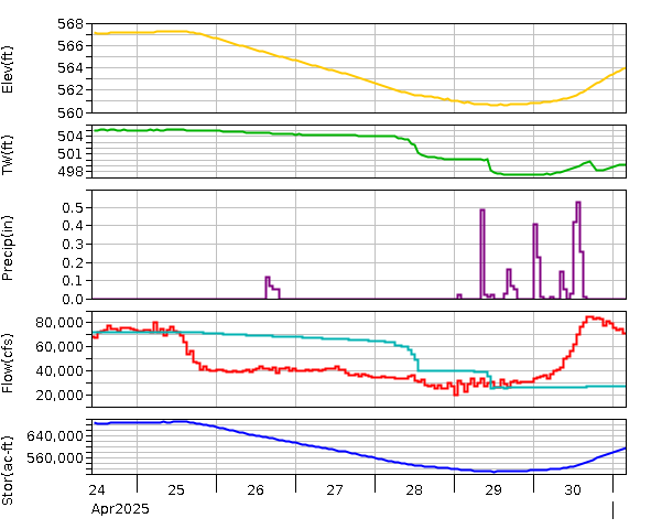
Fort Gibson Lake near Fort Gibson, OK
 |
| Cody Baertschi commented on a post |
 |
| Cody Baertschi commented on a post [Note from the angle of the tainter gate arms that these flows are created with a small opening of the gates.] |
 |
| Cody Baertschi commented on a post |
I assume the 40' by 35' tainter gates are 35' tall. (So tainter is no longer capitalized. That word is the last name of the inventor of this design.) The above description confirms that these huge gates for a flood control reservoir can seriously impact the downstream river. Specifically, they can discharge 986k cfs into a river that can handle 100k cfs within its banks. I wonder how high the gates are raised to pass 986k cfs. But we don't know the flood stages of the river. If it has a lot of flood plain area, the river could leave its banks and handle a higher flow before structures are impacted. But I suspect a factor of 10 (986/100) would flood structures along the downstream river.
Note that in 1943, before the dam was operational, an 8.88" rain caused a 400k cfs flow in the river. To put this in perspective, in the Chicagoland area, 8" is not that unusual. We once had 17" in 24 hours!
8 of 30 photos posted by Andy Michel with the comment: "Fort Gibson Dam Equipment Photo Dump."
 |
| a |
 |
| b |
 |
| c |
 |
| d |
 |
| e |
 |
| f |
 |
| h |
 |
| h |
Later, the videographer turns around and you can see a bunch of gate bays in a row.
 |
| Facebook Reel Andy Michel: 30 tainter style spillway gates here. |
No comments:
Post a Comment