 |
| HAER PA,2-PITBU,64--12 (CT) 3/4 VIEW FROM RIVERBANK, FROM SOUTH. - Liberty Bridge, Spanning Monongahela River, East Carson Street & Second Avenue at State Route 3069, Pittsburgh, Allegheny County, PA |
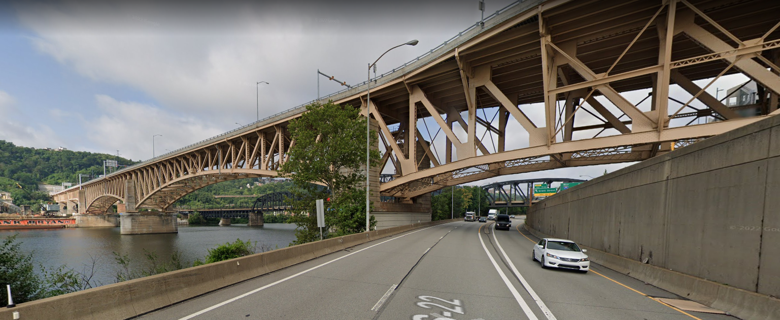
On the left side of this image you can see the concrete retaining wall above the tunnel's north portal. Also of interest is that there are still some industrial buildings along the river.
 |
| Street View |
On the left side, you can see some of the concrete of the tunnel portals.
 |
| Street View |
 |
| Jackson-Township historical preservation added Liberty Bridge in Pittsburgh on April 30, 1937. The Liberty Bridge, which was completed in 1928, connects downtown Pittsburgh, Pennsylvania, to the Liberty Tunnels and the South Hills neighborhoods beyond. It crosses the Monongahela River and intersects Interstate 579 at its northern terminus. It was designed by George S. Richardson and cost $3,456,000 to build. Ivan Rostosky: Mon Lock #1 prior to demolition seen to the right. Very Few good photos of it. Clear view of the Armstrong Tunnels as well! |
 |
| 𝗥𝗲𝗺𝗲𝗺𝗯𝗲𝗿 𝗪𝗵𝗲𝗻: 𝗣𝗲𝗻𝗻𝘀𝘆𝗹𝘃𝗮𝗻𝗶𝗮 and Ohio posted Pittsburgh Skyline Vintage Postcard! Circa 1930-1945 |
North Portal
 |
| Street View |
South Portal
 |
| Street View |
 |
| Zehra Kalay posted Did you know that the Liberty Tunnels when first built were the longest auto tunnels in the world? The Liberty Tunnels (also known as the Liberty Tubes) are a pair of tunnels located in Pittsburgh, Pennsylvania, United States that allow motorists to travel between the South Hills of Pittsburgh and the city, beneath Mt. Washington. The tunnels were vital in the expansion of the South Hills suburbs by providing a direct route to the city, eliminating the time-consuming task of navigating around or over Mt. Washington and its inclines. Opening in 1924, the Liberty Tunnels are the longest automobile tunnel in the City of Pittsburgh. Following the completion of the Liberty Tunnels, the Liberty Bridge was completed and linked to the tunnels on March 27, 1928. The bridge and tunnel combination gave motorists and pedestrians a direct route to the city without traveling over or around Mt. |
I wish this had better resolution. Note the old gas pumps in the lower-left corner.
 |
| Jackson-Township historical preservation posted In 1919, the Allegheny County Commissioners decided to bore twin tubes through the base of Mt. Washington in Pittsburgh to create the Liberty Tunnels. The project cost $6 million which translated in today’s dollars, would be $82 million. When they opened in 1924, the Liberty Tunnels were the longest auto tunnels in the world. Each tunnel is more than 5,000 feet [1.5km] long and 26 feet [8m] wide. About 400,000 cubic yards of earth and rock were excavated to build them. (Photo from Deacon Vic Satter via https://www.facebook.com/groups/132768683480072/) |
.jpg) |
| Patrice M. Hewitt posted The northern portals of the Liberty Tunnels, still under construction in August 1923, as compared with a similar Google Map view from March 2025. Construction began in April 1920, and by August 1923 the twin tubes were nearing completion. A public inspection was to be held the following month. The Liberty Tunnels were opened to traffic in January 1924. Note that, in the absence of the Liberty Bridge and McArdle Roadway, both completed in 1928, traffic on the north side of the tunnels flowed to and from the intersection with Arlington Avenue. Vintage photo credit unknown. |
.jpg) |
| Tom Binz commented on Patrice's post |
 |
| Tom Binz commented on Patrice's post |
 |
| Tom Binz commented on Patrice's post |
 |
| Jackson-Township historical preservation posted Construction workers and a crane performing work inside the Liberty Tunnels in Pittsburgh in 1920. A Public Works article states that there was 127,000 yards of rock excavation and that workers earned eleven hours pay for every nine linear feet excavated. They received twelve hours pay for ten feet, no matter how long it took. This policy dramatically sped up the excavation process. Much of the rock excavated was used as land fill to create McKinley Park. (Photo from https://www.facebook.com/groups/53337549258/) |
 |
| Jackson-Township historical preservation posted South End of the Liberty Tunnels at 12:00 noon in Pittsburgh in 1940. (Photo from https://historicpittsburgh.org/) |
 |
| Ashley Schmidt posted Liberty Tunnel Construction 1920 The construction of Pittsburgh's Liberty Tunnel was a major engineering feat in the city's history, designed to meet the growing demand for automobile transportation in the early 20th century. One of the first vehicular tunnels in the eastern United States, the tunnel was designed to relieve traffic congestion and provide an efficient passage between South Hill and downtown Pittsburgh. The Liberty Tunnel's groundbreaking ceremony was held in February 1919, by contractor Booth & Flinn Ltd. The tunnel was designed and supervised by Almos D. Neeld, an engineer who lived in Pittsburgh. [Several comments indicate that it is called "Liberty Tubes."] |
This photo of the Panhandle Bridge also has a good view of the Liberty Bridge and North Portal.
 |
| BrooklineConnection via Dennis DeBruler, License: Creative Commons Attribution-Share-Alike (CC BY-SA) |
The 5,889' Liberty Tubes penetrate the 400' high, 5-mile long Mount Washington and provide access to the South Hills. [pghbridges-bridge, pghbridges-tunnel]
.jpg) |
| Postcard via BridgeHunter-bridge |
 |
| 𝗥𝗲𝗺𝗲𝗺𝗯𝗲𝗿 𝗪𝗵𝗲𝗻: 𝗣𝗲𝗻𝗻𝘀𝘆𝗹𝘃𝗮𝗻𝗶𝗮 and Ohio posted Liberty Bridge Entrance To Tunnels • Pittsburgh • Circa 1950s! |
Looking back the other way.
 |
| 𝗥𝗲𝗺𝗲𝗺𝗯𝗲𝗿 𝗪𝗵𝗲𝗻: 𝗣𝗲𝗻𝗻𝘀𝘆𝗹𝘃𝗮𝗻𝗶𝗮 posted Liberty Bridge • Pittsburgh • 1937! |
 |
| 3D Satellite |
The tunnels were completed in 1922, but the opening was put off until 1924 after a ventilation solution was added. That solution was not adequate so vertical shafts were added at the midpoints to a ventilation building on top of Mt. Washington. "Carrying 25,000 vehicles in 1932, the Tubes were over their designed capacity. In 2000, the average daily traffic was 63,027." A proposal for an interchange between Saw Mill Run Blvd. and West Liberty Av. was made in 1919. An interchange was finally built in 1999. [phgbridges-tunnel]
 |
| 3D Satellite |
 |
| Haunted Pittsburgh LLC posted HAPPY 100th BIRTHDAY, LIBERTY TUNNELS In January 1924, the public got to ride through the newly built tunnel—the county conducted a series of test runs with actual cars and trucks to try out the ventilation system. At 5,889 feet, it was the longest concrete traffic tunnel in the world designed for automobiles when it opened. There was no Liberty Bridge yet (it opened in 1928)—and the ventilation was a problem, to put it charitably. The experts knew that ventilation was needed, and the county was working to install a system, but they opened the tunnel before they got it right. On May 10, 1924, tragedy struck. A streetcar strike caused cars to swamp the new tunnel. Some 33 people were overcome by the carbon monoxide, 100 others were affected. Soon, a proper ventilation system was installed (the Fan House on Secane Avenue in Mount Washington is massive). Since then, the tunnel has seen every permutation of the human condition: babies have been born there and people have died there. A highlight: the inbound tunnel was closed on February 15-16, 1990, from 9 p.m. to 6 a.m. for filming of a scene in the Academy Award winning “Silence of the Lambs.” Hannibal Lecter had escaped from his cell (filmed at the Soldiers & Sailors Memorial Hall & Museum in Oakland), culminating in a shocking scene as an ambulance flew through the Liberty Tunnels. The scene runs just a few seconds, but it culminates in a moment that may be the high-water mark of movie horror. HAPPY BIRTHDAY, LIBERTY TUNNELS Will Moore: Real Western Pennsylvanians know these are actually called the "Liberty Tubes." Dan Waters: Will Moore and we know we're going to be in that dam thing an hour. Loraine Nolder: Or, just "The Tubes". |
.jpg) |
| Straight Outta Pittsburgh posted Construction in progress on the Liberty Tunnels, 1920. Van Michael: My father made me drive through the Liberty Tubes on my learners permit (1970)......scared me to death.....made it and it worked, wasn't scared anymore. I was 16 when Dad hade me drive through the tubes. Squirrel Hill tunnel was a cake walk after the Liberty Tubs. Jackson-Township historical preservation posted Cosntruction of the Liberty Tunnels (Tubes) in Pittsburgh in 1920. Larry Mishkar: Here's information about the contractors, Booth and Finn: https://en.wikipedia.org/wiki/Booth_and_Flinn |
 |
| Stuff Thats Gone posted Courtesy of Brookline connection. Great then and now. Did you know that when you came through the liberty tubes in 1928 there was no bridge to cross? Approaching the outbound Northern Portal of the Liberty Tunnels, on the ramp from Arlington Avenue, in 1925, just a year after the Twin Tubes opened, as compared with a similar current Google Map image. In 1925, the Liberty Bridge was in the early stages of development, with work on the bridge piers only just beginning. Construction had not yet begun on Mount Washington (McArdle) Roadway. The automobile in the upper photo has turned off of the tunnel approach ramp onto what was then called Mattisee Street, where a few hillside homes were located. Mattisee was eliminated during the construction of the Mount Washington Roadway, although a some of the homes, near the intersection, remained for a few years. The Liberty Bridge opened in March 1928, followed by the Mount Washington Roadway shortly afterwards, in July of that same year. The tunnel/bridge/roadway intersection originally contained a large traffic circle and monument. The circle was condensed in 1933 and eventually replaced with a traffic signal in the 1940s. |
No comments:
Post a Comment