4 drone photos and a video taken Jul 6.
When the Des Plaines and Mainstream tunnels were built, the plan was that they would empty into part of the Vulcun Materials Quarry. But the MWRD and Vulcun could not agree on a price. So MWRD sacrificed 17 of their
to dig a reservoir on their own land. They built
that ties into Vulcan's stone storage, sorting, and delivery facilities.
Phase I, which is north of the crushing plant and will hold 3.5 billion gallons, will open near the end of 2017. That is why the
. I caught a tour on the first day, Aug 6. After it becomes operational and they let wastewater into the reservoir, I'm sure it will be off limits to public view. (On the tour, I learned that Joliet road is closed between 55th and East Ave. because Vulcan caused a collapse in the road.) Phase II will hold an additional 6.5 billion gallons and is scheduled for completion in 2029. The tunnel system was done in 2006. One reason it has taken so long to dig the reservoirs is that the housing (and construction) collapse in 2008 caused the market for stone aggregate to dry up.
 |
| 20170806 1530 |
The tour started at the
Mainstream Pumping Station, but we were not allowed to go down to see the pump houses. They have other tours for that.
I took a photo of the backdrop that they had for photo shoots because it is a view from the bottom that I knew I would not be able to take myself.
The tour bus first went past their
biosolids drying lagoons.
Then we passed Phase II, which they are still digging.
The overburden was hauled south to create a recreation hill, Centennial Hill, in Columbia Woods Forest Preserve. Although I hope I can access
the Centennial Trail from Route 83 because the hill is a long ways from the Columbia Woods Willow Springs Road entrance.
 |
| Satellite view captures Centennial Hill when it was still being constructed. |
Another overview of Phase II. Near the right, in the middle, is a drill set up to create another hole for explosives. (The tours was on Sunday so nothing was operating.)
We see that drill at about the same location in the photo, but at a different angle. They have just begun the next layer of the dig.
Vulcan is in charge of the mining operation, but MWRD had to supply six trucks at $2 million apiece and other equipment. Note that there are three more drills on top of the wall that separates Phases I and II.
The open-air building is where the haul-trucks dump their loads into the crusher. The partial view of the building on the left is used to maintain the equipment.
One advantage of taking a lot of pictures is that I can see things when I zoom in on a photo that I did not notice during the trip.
Specifically, I see there are at least four more trucks parked up on the wall.
Three more shots as we drove past the wall.
On the other side of the wall we can see the tops of two cranes that they are using for some final construction in Phase I. It also appears that part of completing a reservoir is putting a chain-link fence around it.
With 18mm, I managed to get a shot of most of Phase I. In particular, we can see the access road along the far wall. The reason the wall looks darker above the road than below it is because it is lined with a steel net designed to keep any rock falls close to the edge of the road to avoid hitting any trucks.
I stood up to get above the fence to get this shot of a train on the IHB tracks. The truss bridge is over the Sanitary and Ship Canal. This picture makes me appreciate than none of my other pictures picked up window glare. It looks like it is being pulled by a UP engine.
This view is looking back at the Phase I side of the wall. I put a red rectangle around the opening of an old interceptor sewer that they had to reroute around this dig. In fact, the new sewer line was one of the responsibilities of our tour guide, and he was obviously very proud of the work.
The train was a mixed freight.
Now we are off the bus. This is an overview of the overview.
Walking up to the barricades and taking a wide-angle shot down into reservoir.
A tighter shot of the reservoir. The "tiger teeth" is where the Des Plaines Connecting Tunnel enters. The tiger teeth slow the lateral flow and turn the flow into the longitudinal flow that this reservoir needs. They are having to build the new tunnel because the Des Plaines Tunnel had stopped by Vulcan's quarry. You can barely see the two cranes by the far wall.
They would not let us walk down along the left wall so that we could try to see into the tunnel exit that is sticking out a little on the right in this view. I started walking down the road, and I was told to come back. The "drain" to the pumping station is the hole near the back on the right.
We have had enough rain storms lately to demonstrate that the bottom is not sloped towards the drain. When the guide overheard some of us talking about that, he explained that was deliberate because it makes the reservoir act like a big settling pond. During dry weather they plan to come in and dig out the residual biosolids. So that will reduce the workload on the
Stickney Water Treatment Plant.
Quite a bit of the guides narrative that he read from a Public Relations script concerned the work to keep the dirty water out of the ground water and the ground water out of the hole. They created two grout walls, one near the edge of the hole and another 15 feet away. Each wall was built with 6" holes drilled every 5' to a depth 70' under the floor of the reservoir or 370'. Then they pump grout into the holes under high pressure to fill any cracks in the
dolostone. To seal the overburden, they built a 3' wide slurry wall using bentonite. Bentonite is a clay that packs so well it becomes impervious to water.
Here we see both grout walls, but I'm lined up on the one 15' away. We also see a couple of boys on a rock pile picking out their free rock sample. When I got off the bus, someone commented about how they liked their rocks. Sure enough, I saw one still carrying a big fist full of rocks.
I assume all of those watermarks we see on the walls were made by ground water before they did their grouting.
This was the diagram that the guide used to explain the "plumbing." The arrows on the green line between the "drain" and the pumping station are going in the wrong direction.
It was on the edge of the overview.
I'm now doing a photo dump of the pictures I took when I left since they should be rather redundant.
I took this picture to catch the autotrain that was still rolling by as we left. When I went back to the bus, I noticed it on the IHB bridge. So I waited and made
a video of its arrival.
Update:
 |
WaterOnline article
"Crowds flock to MWRD's Stunning View of McCook Reservoir"
[The article provides a stat I've been looking for: the tunnels themselves can hold 2.3 billion gallons. I also learned that the two grout walls connect with an impermeable natural layer of shale that is under the reservoir at around 325 feet. The age of the dolostone is 400 million years.] |
 |
MWRD posted
Today [2017 Dec 4] we marked a historic milestone as we celebrated the completion of Stage I of the McCook Reservoir, one of the biggest achievements to date in the MWRD's Tunnel and Reservoir Plan (TARP). The McCook Reservoir will mitigate flooding and prevent pollution from entering our waterways by serving as a holding place to allow our treatment plants more time to keep up with significant rain events. The addition of Stage I will more than triple the storage capacity for the 3.1 million people it serves across Chicago and 36 suburban communities. It increases the 1.6 billion gallons currently stored in two separate tunnel systems to a combined 5.1 billion gallons of storage that is estimated to provide an average of $114 million per year in flood damage reduction benefits. We thank our project partners at the U.S.
Army Corps of Engineers and for our guests today who have all contributed to this vital project: Sen. Dick Durbin, U.S. Rep. Mike Quigley, U.S. Rep. Dan Lipinski, USEPA Acting Regional Administrator Robert Kaplan, Region 5, U.S. Army Corps of Engineers Chicago District Commander Col. Aaron Reisinger, Illinois EPA Director Alec Messina, McCook Mayor and Cook County Commissioner Jeff Tobolski, Kevin Burke, vice president of the Operating Engineers Local 150, and Jack Darin, director of the Sierra Club Illinois Chapter. |
WTTW tour of the McCook Reservoir
MWRD
posted about
WTTW's coverage of the ribbon cutting ceremony.
CHICAGO AREA RESERVOIR TO SAVE ESTIMATED $114M IN FLOOD AND POLLUTION REDUCTION
Update: We had enough rain to use the reservoir, so there have been some articles about it receiving water:
estormwater,
workingpressure, and
their press release with three photos:
 |
| 1 |
 |
| 2 |
 |
| 3 |
MWRD
posted three more photos with the comment:
Here are a couple of more photos taken at the McCook Reservoir today. The poles and chains you see in the midst of all that flow are used to tether the solar powered aerators, keeping them in place while allowing them to float up and down with the water elevation changes.
 |
| 1 |
 |
| 2 |
 |
| 3 |
 |
| 1 |
 |
| 2 |
 |
| 3 |
MWRD
posted four photos with the comment:
The MWRD’s Tunnel and Reservoir Plan is hard at work following another round of showers. Operating at full capacity, stage I of the McCook Reservoir collected 3.5 billion gallons of water, while nearby crews continued the expansion of the Des Plaines Tunnel System to improve the connection to the reservoir. Without this critical infrastructure, billions of gallons of water would pollute our waterways and flood our basements and streets.
 |
| 1 |
 |
| 2 |
 |
| 3 |
 |
| 4 |
 |
MWRD posted
For immediate release
October 31, 2018
MWRD, Army Corps project earns mega engineering award from ASCE
The Illinois Section of the The American Society of Civil Engineers has recognized the Metropolitan Water Reclamation District of Greater Chicago (MWRD) and project partner, the U.S. Army Corps of Engineers USACE, with a prestigious honor in mitigating flooding and improving local water quality.
For their roles on the Chicago Underflow Plan (CUP) and McCook Reservoir project, the USACE and MWRD were awarded with the Illinois Section of the American Society of Civil Engineers’ (ASCE) Outstanding Civil Engineering Achievement, Mega Project Award. The award was presented at the ASCE Illinois Section Awards Dinner held earlier this month at The Crystal Gardens on Navy Pier.
“Congratulations to our engineers at the MWRD and U.S. Army Corps of Engineers’ Chicago Office for collaborating and fulfilling a critical plan that will protect our waterways from pollution and our homes and streets from flooding,” said MWRD President Mariyana Spyropoulos. “The McCook Reservoir has been showered with awards in its first year, but it is the heavy rain showers that the reservoir protects us from that allows it to truly make its mark.”
The USACE’s CUP and the MWRD’s Tunnel and Reservoir Plan (TARP) consists of three reservoirs intended primarily for flood control for the Chicago area serviced by combined sewers. It also works to prevent pollution in local waterways. Two of the TARP reservoirs are completed, including the Majewski Reservoir (350 million gallons) and the Thornton Composite Reservoir (7.9 billion gallons). The McCook Reservoir is being constructed in two stages; the first stage was completed last December and the second will be done by 2029.
Benefitting 3.1 million people living in Chicago and 36 suburbs, McCook Reservoir Stage I captures and stores water before it can be sent by gravity and pumped from TARP to MWRD water reclamation plants to be cleaned and released to waterways. Since coming into service at the beginning of 2018, the reservoir has captured 20 billion gallons of water. Stage 1 of the reservoir has 3.5 billion gallons of storage capacity and provides an estimated $114 million per year in flood reduction benefits, while also capturing untreated water that previously overflowed into waterways during storm events. Stage II of the reservoir, due for completion by 2029, will be able to hold an additional 6.5 billion gallons. When complete, the four TARP tunnel systems and three huge reservoirs the tunnels flow into, will have a capacity of more than 20 billion gallons.
“Thank you to the Illinois Section of the American Society of Civil Engineers for recognizing these crowning engineering achievements made through the implementation of the Chicago Underflow Plan and the construction of the McCook Reservoir,” said MWRD Commissioner Frank Avila. “TARP is putting tax dollars to work and providing relief at a time when unpredictable weather patterns are impacting our daily lives.”
When it is completed, McCook will surpass the MWRD’s Thornton Composite Reservoir as the largest reservoir of its type in the world. The reservoir will be so large that more than 11 Soldier Field Stadiums could fit inside it, and is nearly deep enough at 300 feet to stack another 11 on top of that. To create Stage I of the combined sewer reservoir, the MWRD removed 9.4 million cubic yards of overburden, enough to fill the Merchandise Mart eight times over.
“The McCook Reservoir project is an exceptional project that reduces the flood risk to over 3 million people in the Chicagoland area,” said William A. Rochford, P.E., Chief, Geotechnical & Survey Section, USACE. “This project was envisioned by the MWRD many decades ago and was implemented by the Corps in partnership with the MWRD through the efforts of many individuals of both our organizations and the many design and construction firms needed to bring the project together. It required many innovative and creative solutions to significant challenges in order to safely construct a reservoir 300-ft below ground between two waterways and next to an interstate highway. The benefits of this project have been demonstrated almost immediately since becoming operational this past January, having been filled four times so far this year. It has been a project that has advanced the state of the art in numerous areas and has been a great pleasure and professionally rewarding to be a part of the team that is making this project a success.”
|
MWRD
posted eighteen photos with the comment:
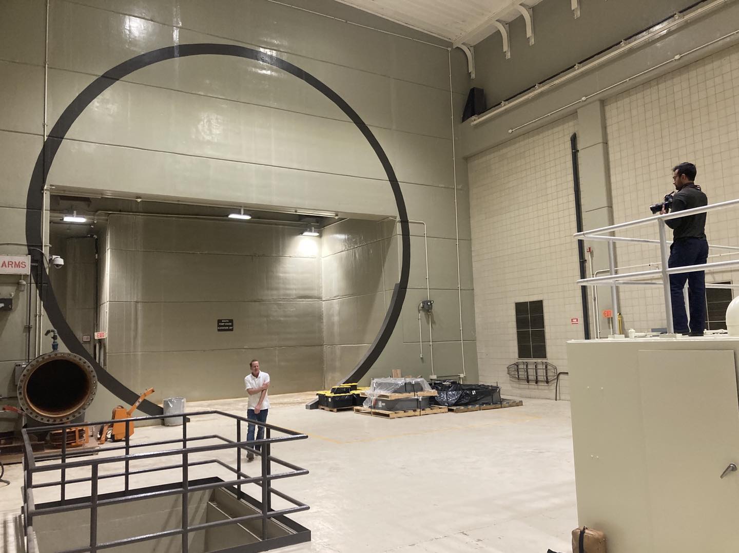
Dry conditions have allowed work to progress on the Des Plaines Inflow Tunnel, part of the MWRD’s Tunnel and Reservoir Plan. Today we welcomed photographers from National Geographic to explore this critical work being completed to protect our drinking water supply in Lake Michigan, preserve our waterways from pollution, and mitigate flooding for communities that rely on combined sewer systems. The inflow tunnel will eventually connect to the McCook Reservoir, which will capture and store combined stormwater and sewage that would otherwise overflow from sewers into waterways in rainy weather. This stored water is pumped from TARP to Stickney Water Reclamation Plant to be cleaned before being released to waterways. The tunnel diameter transitions from 20 foot to 33 foot before meeting a concrete plug that prevents water from the active tunnel from entering the section to keep workers dry as they complete the tunnel.
 |
| 1 |
 |
| 2 |
 |
| 3 |
 |
| 4 |
 |
| 5 |
 |
| 6 |
 |
| 7 |
 |
| 8 |
 |
| 9 |
 |
| 10 |
 |
| 11 |
 |
| 12 |
 |
| 13 |
 |
| 14 |
 |
| 15 |
 |
| 16 |
 |
| 17 |
 |
| 18 |
"In the photo above, West Bull Nose, shows the exit of a Deep Tunnel in Chicago. It’s a 109-mile, massive tunnel that helps prevent flooding on the streets. Its pictured with a trickle of water, but during a heavy rainfall the reservoir can fill completely to 17.5 billion gallons." [
ChicagoCurbed] I think 17.5 billion is too high for a reservoir. I suspect that is the total capacity of all the MWRD's reservoirs.
The above photo was used on Page 17 of the Summer/Fall 2019 issue of
In the Field with this caption:
"West Bull Nose." This is an exit to Chicago's 33'-diameter deep tunnel where water will flow freely into the holding reservoir. When there are storms and overflow, the water is diverted through the deep tunnel system into reservoirs to await treatment at a nearby Wastewater plant. After processed and disinfected from human bacteria, the clean water goes back into waterways.
 |
| 20170806 1594 |
To the right is a copy of one of the photos I included above. Below is a closeup I used to determine that Brad's photo was taken at the McCook Reservoir.

An MWRD
posting that has the above two "full" photos plus
a pannable 180-degree view.
Tom Skilling
posted about the full Phase I reservoir.
Time lapse video of the reservoir filling up. They need to put better hoods over the camera lenses. They are wet quite a bit of the time. The MWRD
posting indicated the video covered 2 days.
The March 18, 2018 Chicago Tribune had a front page article about the filling of this reservoir. First of all, the filling shows that the second phase that will expand the capacity from 3.5 to 10 billion gallons by 2029 is needed. (The tunnels themselves hold 1.6 billion gallons.) This article indicated the initial fill took only 20 hours. "Officials at the water reclamation district were alarmed by the rate of sewage and runoff rushing into the section that opened in December. If the storm had dumped a little more rain on the area, St. Pierre acknowledged, even the larger reservoir would have been filled within a day." Yet a couple of paragraphs later, St. Pierre said "This time the system held on for 20 hours, which makes me fairly optimistic that what we saw last month will be relatively rare."
One of the things I haven't seen explained recently is that the reservoirs do hold the "first flush." That is the first gush of water caused by a rainstorm flushes all of the "stuff" that is setting in the sewer pipes into the reservoir. That means, if later in the storm, water backs up because the TARP is full, it is relatively clean storm water rather than sewage that is coming up into basements, onto streets, and overflowing into the rivers.
In 2018, in its first year of operation, the reservoir captured 27.2 billion gallons of water. Combined with the adjoining Mainstream and Des Plaines tunnels that feed into the reservoir, the whole McCook system captured 46.1 billion gallons in 2018. From January through July 2019, the entire TARP system captured 58 billion gallons of water. If not for TARP, that is 58 billion gallons that could have polluted local waterways. [Oct 9, 2019, post]
MWRD
posted three photos with the comment:
Excavation continues at McCook Reservoir Stage II, which will ultimately be able to hold 6.5 billion gallons of combined sewage within the next decade. Stage I was completed in 2017 and can hold up to 3.5 billion gallons prior to treatment at a water reclamation plant. Learn more about the MWRD’s massive Tunnel and Reservoir Plan (TARP), designed to mitigate flooding and protect combined sewage from entering our waterways https://mwrd.org/…/defa…/files/documents/Fact_Sheet_TARP.pdf. Watch a livestream of McCook Reservoir Stage I at https://mwrd.org/tunnel-and-reservoir-plan-tarp
Kody Thames ...and when it is complete, Route 66 will open back up, right? 😉
Laura Barnat Route 66 was destabilized in 1998 while the mine was open. Vulcan apparently mined too close to the ridge the roadway was built over. Route 66 started buckling and dropped in several places. Vulcan paid a large settlement. It's unlikely the road will be rebuilt. The road closure has nothing to do with MWRD work.
[
US-66 Overview]
 |
| 1 |
 |
| 2 |
 |
| 3 |
 |
Nick Hart posted
Shortly after passing under the Indiana Harbor Belt mainlines, the Metropolitan Water Reclamation District of Greater Chicago makes an afternoon run with 7 loads for the fields. With SW1 #3 leading the way, the train is making its way down the portion of the line where the track parallels the McCook Reservoir and the Chicago Sanitary & Ship Canal. All we needed was an IHB train in the background. Next time perhaps. Taken 03-04-21 in McCook, IL. |
MWRD
posted three photos with a comment:
Our McCook Reservoir Stage I is near capacity this afternoon holding nearly 3.5 billion gallons of stormwater and sewage that otherwise would have polluted waterways or backed up into basements and streets. From here it will flow back down a tunnel by gravity to our Stickney Water Reclamation Plant for treatment.
Meanwhile, excavation work continues on McCook Reservoir Stage II to hold an additional 6.5 billion gallons of water. You can play a role by conserving water use at home to minimize the amount of water flowing down our drains and overwhelming our sewers during heavy rains. To view a livestream of the reservoir, visit
mwrd.org.Where in McCook is this located?
 |
| 1 |
 |
| 2 |
 |
| 3 |
 |
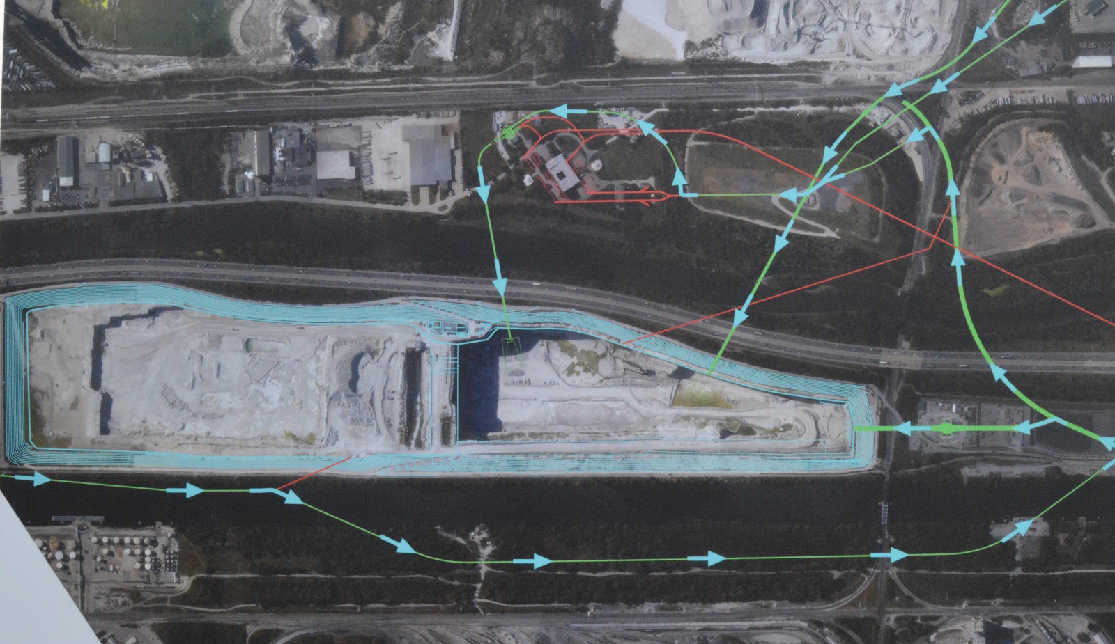
Dennis DeBruler commented on Greg's comment
The blue part is today's reservoir. The white part is Stage II, which they are still digging. Out-of-frame to the Southwest are MWRD's remaining sludge drying pits. Out-of-frame to the Northwest is the Vulcan Material Co. that markets the stone that is dug out of the reservoir.
41°46'45.5"N 87°49'59.8"W |
MWRD
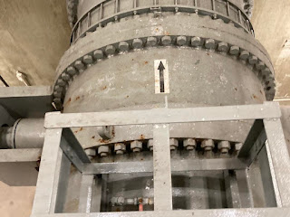
posted eight photos with the comment: "In the bowels of our Mainstream Pumping Station, today we welcomed the Wall Street Journal for a visit to the suction valve gallery and other hard working industrious pumps conveying 568 million gallons of water per day from our McCook Reservoir to our Stickney Water Reclamation Plant. Part of our Tunnel and Reservoir Plan (TARP), the reservoir, tunnels and pump station protect our waterways from pollution and our communities from flooding. The reservoir was holding more than 1.7 billion gallons of water this morning, but as we pump it down, we are better prepared for the next storm. Only a few years down the road, we will complete the second stage of the McCook Reservoir to add another 6.5 billion gallons of storage."
 |
1
|
 |
| 2 |
 |
| 3 |
 |
| 4 |
 |
| 5 |
 |
| 6 |
 |
| 7 |
 |
| 8 |
Jul 6, 2026. I wonder when the extension is supposed to come online.


Thank you for publishing such a detailed page about Chicago's two massive reservoirs. It's amazing the resources we have.
ReplyDeleteI found this page by asking Gemini, "How quickly does the Thornton reservoir in Chicago drain?" It referenced your page here, with the answer that it takes about 10 days to pump out 2 billion gallons of water.
I'm curious how long it would take to pump out 7.9 billion gallons of water. I"m assuming the math isn't as simple as 4x longer.