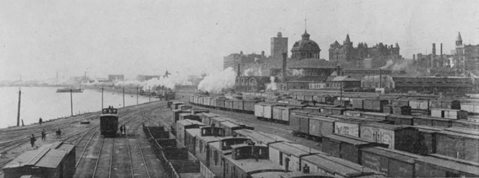
Paul Petraitis posted three photos with the comment: "End of the line ICRR, undated photography, maybe taken from atop the Tribune Bldg? From the ICRR Archives/Don Horn"
 |
| 1 Paul Jevert Good shot of the Michigan Central Freighthouse to the starboard side of the laker excursion boater! |
 |
| 3 Ava Francesca Battocchio 1901 Sanborn Map collection for Chicago has a really sweet grain elevator section. Very attractive. |
 |
| 2 |
Two photos that are accessible from Paul Webb's share:
 |
| 1 |
 |
| 2 |
 |
| MWRD shared View looking south from Tribune Tower down Michigan Avenue - 1925 versus today. Mike Tuggle also posted the 1925 view. MWRD shared Living History of Illinois and Chicago posting 1925 view of Chicago's Michigan Avenue (south of the river), Grant Park, and the Wrigley Building. [London Guarantee Building is the one in the middle.] |
 |
| David M Laz posted This 1857 bird’s-eye view of Chicago shows that the area where Grant Park now sits was then completely under water. An Illinois Central Railroad trestle acted as a breakwater. |
 |
| Paul Petraitis posted Our original river/rail connection, 1858, probably a Hesler photo. Paul Petraitis Original in the Chicago History Museum collections, a gift of Mrs. Lizzie Moulton Kneeland. Richard Fiedler shared Rick Powell The Buckingham family owned many of the grain elevators at the north end of the IC tracks. Namesake of the fountain and also the tiny town in Kankakee County. |
 |
| David Daruszka commented on Richard's share Image of the IC holdings in the lakefront and river. There was quite a panoply of railroads using IC's first Central Station (#2 in the image). The CB&Q had their first office building next to the station. |
 |
| Thomas Manz commented on Richard's share What was the last business or industry north of Randolph Street to have a rail connection? Bob Hendricks posted April 10, 1937 – Fire breaks out at 4:00 a.m. at the South Shore depot that sits alongside the Illinois Central Railroad station just east of Randolph Street. It doesn’t take long before “flames burst through the roof of the structure, lighting up Michigan avenue in the vicinity of the public library, and attracting hundreds of motorists and loopgoers to the scene.” [Chicago Daily Tribune, April 11, 1937] The fire brings a large response from the Chicago Fire Department as fire fighters keep their distance battling the 2-11 fire while crowds on the Randolph Street viaduct watch the heroics. The twelve-year-old structure was first used by the Illinois Central but was turned over to the South Shore in 1931. This'll be the second time a fire guts the depot. In a May, 1934 fire, five fire fighters were injured. In the above photo the station stands just to the right of the peristyle, which was torn down in February, 1953. Today this is the northwest corner of Millennium Park. |
 |
| David M Laz posted An older view of the downtown IC yard. Note the old Chicago Public Library (now the Cultural center) to the far right. Paul Petraitis 1880's Id guess...I don't see the Auditorium, do you? |
 |
| David Daruszka commented on a post Chicago's front yard was a rail yard. Upon completion of the trestle that brought passenger trains into the city (and protected the lake shore) the Illinois Central began to create more land for their use for freight handling. There were grain elevators, coal storage and numerous warehouses used for the transshipment of freight. The State of Illinois finally put a stop to the illegal expansion, but the damage was done. Much of the freight business was produce, as the IC was noted for shipping bananas and strawberries. Over the years, as the freight business dropped off and the produce market was relocated, the land was vacated but the tracks remained. The IC used this as a way to retain ownership, as removal of the tracks would allow the land to revert to the city. Illinois Center and the aforementioned Prudential Building were built on a portion of this land. The remainder became surface parking for automobiles. The land would be eventually transferred back to the city and it is now occupied by Millennium Park. |
 |
| Dave Creighton posted Chicago. Along the lakefront in 1893. Mike Breski posted Lake front, Chicago, Illinois, circa 1893. https://marmarinou.tumblr.com/page/382 [I didn't see this photo.] |
 |
| Glen Miller posted 1906 postcard of the Illinois Central's yard. The Michigan Central Railroad, a subsidiary of the New York Central, shared track rights with the Illinois Central. The Michigan Central also shared the IC's Central Station in Chicago as well. A switcher locomotive sneaking behind the freight cars, lower right. Glen Miller Vintage Railroad Postcards David M Laz also posted David Daruszka commented on a posting Markham Yard in Harvey wasn't built until 1926. There were yards at Wildwood, Fordham and the main yards on the lakefront. Here's a postcard image of downtown. Jim Arvites posted Postcard view of the Illinois Central yard in downtown Chicago at Pleasure Craft Harbor and Randolph Street circa 1905. Note the Michigan Central passenger cars. The Michigan Central, a New York Central subsidary, used the IC's Central Station for its Chicago - Detroit passenger service until the late 1950's. David DaruszkaDavid and 3 others manage the membership, moderators, settings, and posts for Chicago Railroad Historians. Other railroads that used the station prior to 1871 were the Chicago & Alton Railroad, the Baltimore and Ohio Railroad, The Galena & Chicago Union and the Cleveland, Cincinnati, Chicago & St. Louis Railway from 1886 to 1893. At one time, and for years, through passenger trains were run between Chicago and Dubuque, Iowa. These trains ran between Chicago and Freeport, Il over the Galena & Chicago Union, and between Freeport and Dubuque over the Illinois Central. Two separate trains ran out of both Great Central Station and G&CU’s Kinzie Street Station. The two trains were combined at Oak Park as one train. On the return the train was split and each section ran to the respective stations. |
 |
| From Glen's postcard source above, same vintage [You can use the two water towers to orient this view with the 1880s view above.] |
 |
| Michael Brandt posted An 1893 image of the Art Institute not finished yet. Dennis DeBruler: This photo is old enough to catch both of Illinois Central's grain elevators along the Chicago River. |
All of that smoke can make the cool breezes blowing in from the lake a problem.
 |
| Michael Brandt posted Grant Park in 1892. |
 |
| Grant Park, 1906 from Chicago Curbed |
 |
| Dan Imal posted Grant park 1920. [You can barely see the yards by the river, and that is the point. This shows why a 1915 Smoke Abatement Report forced the IC to electrify its service in Chicago's "front yard."] |
 |
| Chicago newspapers: Turning the pages posted In 1922: Before there was a Tribune Tower. The Wrigley Building opened its doors in 1921. It is considered the first major office building north of the Chicago River. [Note the rows of boxcars inside the U-shaped freight house. And the ship in the lower-right corner being loaded from the grain elevator. To the left of the Wrigley building is the Kraft Plant and they have yet to dismantle the Rush Street Bridge.] Daniel Bovino posted In this 1922 aerial of Chicago, the tallest building is the Wrigley. The Tribune Tower was not yet built. Rush Street had a small bridge behind the Wrigley building that spanned the Chicago River. In the foreground are train sheds. They were located at the IC's Mile Post 0. This represented the beginning of the Illinois Central railroad. Paul Webb shared |
 |
| Historic Chicago posted Aerial view of Chicago (1922) |
By 1927 the large grain elevators built with wood along the river served by the IC and other tenants of Central Station such as NYC's Michigan Central had been replaced by more freight houses.
Track side images of the freight houses along Michigan Avenue near the river.
See Prudential Building for some more photos of the IC freight yards.
Update: I thought I already had a posting on IC's South Water Street Freight House. At least I didn't post duplicate topics. I just copied the other content to here. I include Edward Jarolin's posting even though it is a duplicate of David Habben's posting because it has better color.
Edward's comment:
 |
| Don Andrade posted Looking South from the top of the Tribune Tower at night, 1927. [This shows more of the IC yards to the east. Too bad it's an "artsy" nighttime shot instead of an informative daytime shot.] |
 |
| Mike Tuggle posted Chicago at the river, 1943. |
 |
| Curtis Carter posted 1954 - Looking north on Michigan Ave. Prudential Building under construction. What a GREAT idea to get rid of the freight train yard and above-ground parking lot. |
 |
| Alexander Goman >> Forgotten Chicago Near the north end of the Illinois Central looking southish. [This shows the large number of outbound boxcars they would park between the two freight handling wings.] |
 |
| David M Laz posted The old IC yard just north of Monroe, where Millennium Park and Illinois Center now stand. [Note the crosswalk at the end of the boxcars is closed in this shot.] |
 |
| Mike Breski shared Looking south west at Michigan Ave and Grant Park, 1957, Chicago. https://calumet412.com/page/404 Dennis DeBruler shared, but the new Facebook won't give me the link! Note the IC freight house in the middle of the photos south of Randolph. This view shows that it had truck trailers on the east side and rows of boxcars on the west side to handle LCL (Less Than Carload freight). In a few more years the Interstate system will become large enough that those trailers and boxcars would disappear from here. 
Author
While verifying that LCL was the correct acronym, I found this explanation of how it LCL was handled. I'm not a subscriber to Trains, so this link should be public. In particular, note "greyhounds" answers.
I remember the term LCL being used in the 70's. I assumed it was a single location until a year or 2 ago. FB told me this post went gainst community standards and pulled it. I must have a scarlet letter. Author Mike Breski Thanks for letting me know why the share broke. I was going to create a dummy group today and do some testing.Did Facebook call it spam because of self-promoting? I had some comments blocked because of "community standards." It turns out that I had added links for Google Maps to several posts as a comment after I researched the location of the post. (Typically a bridge.) I have no commercial interest in Google Maps, but their AI doesn't know that. This policing is why I avoid adding links to my blog for most topics. One could argue that it is self-promoting even though my blog is not monetized. |
 |
| Dennis DeBruler commented on his share
I think these are the LCL containers, flat cars and crane developed in the 1920s that the Trains thread above indicates was outlawed in 1931 by federal regulators.
|
Track side images of the freight houses along Michigan Avenue near the river.
 |
| Frank Smitty Schmidt posted NYC switch engine working at the IC's South Water St freight terminal in 1943. NYC did lease space from them. Delano / OWI |
 |
| A Jack Delano Photo South Water Street Freight Depot - Chicago, 1943 [LoC] |
 |
Gregory Russell commented that the RR cars by the freight warehouse are directly on top of where Stetson Street is now. [LoC] |
 |
| David Habben posted I finally found out what "Blended 33 to 1" meant. For consistency, they blended 33 vats of beer together each time they bottled it so it was as close to the same flavor every time as possible. Chet Lunsford South Water Street freight depot of the Illinois Central Railroad, Chicago. May 1, 1943. Photo - Jack Delano FSA/OWI Glen Miller They took down this sign to make room for the Prudential Building which was built on air rights over the railroads. [Before it was a PBR sign, it was a Chevrolet sign.] Chet Lunsford The sign was animated and employed a company of workers to keep it operating. Here is a video explaining the workings of the sign when it was the "Bow Tie" Billy Hartford Just amazed by the crew of men , climbing around without any safety equipment on whatsoever. What is insane to us..was once the norm . Very informative video..thanks . Chet Lunsford A link to a very high resolution image of this photo, via Shorpy. If you look closely, you can still make out the old Chevy bow tie logo on the sign. David M Laz also posted [Jack Delano, May 1, 1943, LoC] |
 |
| Edward Jarolin shared |
The IC yard at Grant Park on Chicago's lakefront. Looking north between Central Station (behind) and the electric line's Randolph St. Station(beyond the Pabst sign).
 |
Martin G. Sorenson posted
Chicago, April 1943. "New York Central diesel switch engine moving freight cars at the South Water Street terminal of the Illinois Central R.R." 4x5 Kodachrome transparency by Jack Delano for the Office of War Information.
Edward Jarolin also posted New York Central SW1 switching at the Illinois Central's Water Street Terminal in Chicago. NYC rented space here from IC. This April, 1943 photo by Jack Delano. A close look will show the original stubby stack on the SW1. Jim Arvites also posted New York Central SW1 #622 switching reefers at the Illinois Central's South Water Street yard by downtown Chicago in April 1943. (Jack Delano Photo) Victor H. Dominguez shared |
Cliff Downey posted two photos with the comment:
The Illinois Central operated one of the largest freight houses in Chicago at South Water Street. The facility specialized in "less than carload" freight, i.e. if a shipper didn't have enough freight to fill an entire freight car, the freight could be loaded into a freight car (usually a boxcar) with LCL freight from other shippers. Each day large volumes of freight moved from the facility. To help improve efficiency, and enable crews to move quickly from one side of the facility to another, the retractable walkway seen in these photos was installed. Typically the walkway sat perpendicular across the tracks. But shortly before the yard switcher arrived to pick up and drop off cars, the walkway swung out of the way, as seen in these two photos. Electric motors moved the walkway across a wooden platform built across the tracks. Only about 5 minutes were needed to move the walkway in either direction. As a side note, part of the outbound freight house was damaged by a fire on the night of March 14, 1957. Despite the damage the facility was open for business the next day. Today, the South Water Street freight house is long gone, and the site is now occupied by Millenium Park. IC photo, 1958, Cliff Downey collection.Paul Jevert shared
 |
| 1 |
 |
| 2 |
 |
| Jack Delano, 1943, LoC |
 |
| Jack Delano, 1943, LoC |
 |
| Jack Delano, 1943, LoC |
 |
| Jack Delano, 1943, LoC Edward Jarolin posted Part of the IC's South Water St. freight terminal in Chicago. April, 1943 photo by Jack Delano Jamal Craft posted Bob Kuberski: It cleaned up nice later! Paul Jevert shared |
 |
| Jack Delano, 1943, LoC |
 |
| Jack Delano, 1943, LoC The building with the statue on top would be Montgomery Wards first Headquarters building. |
 |
| Jack Delano, 1943, LoC |
 |
| Jack Delano, 1943, LoC |
 |
| Jack Delano, 1943, LoC David Daruszka posted Jack Delano again. The Wrigley Building is in the center and The Chicago Tribune Tower is the tall building to the left of the Chessie freight house. Dennis DeBrulerGroup Admin NKP and C&O is a surprise. The NKP came to town on NYC LS&MS tracks (La Salle Station area). The C&O came to town on the C&WI (Dearborn Station area). Bob Lalich C&O of Indiana predecessor Chicago Cincinnati & Louisville originally used the IC from a location in Riverdale called Highlawn, to reach downtown Chicago. Bob Lalich Both NKP and C&O used a connection at the north end of Fordham Yard to access the IC. C&O used NKP's Chicago terminal facilities for some time. They were both under Van Sweringen control for many years. Joseph Tuch Santucci They ran over the IHB? Never heard that before. Also Photo 10 in TheAtlantic Illinois Central Railroad freight cars at the South Water Street freight terminal in Chicago in April 1943 |
 |
| Bob Lalich commented on David's posting It was only for a short period of time, but IHB and predecessor Chicago Hammond & Western were used from a location in Burnham called Louisville Jct to Highlawn. This original route was out of service by 1915. |
 |
| Photo 4 from TheAtlantic A view of part of the South Water Street Illinois Central Railroad freight terminal in April 1943 |
I skipped his night views in the search results except this one because it traces a crewmember walking with a lantern.
 |
| Jack Delano, 1943, LoC |
 |
| Jack Delano, 1943, LoC (source) |
 |
| Screenshot -9:30 from a 1940s film about Chicago |
 |
| David Daruszka posted Looking north east shows the two elevators marking the Chicago River. To the left the the small white building with windows was the original headquarters of the CB&Q Railroad. Dennis DeBrulerGroup Admin What is CB&Q doing in IC territory? I learned just today that CB&Q had offices over where thier tracks curved from heading east to heading north. http://industrialscenery.blogspot.com/.../cb-support... Dennis DeBrulerGroup Admin Was IC so important back then that CB&Q felt they had to have their offices close to the movers and shakers? Then later they thought they were important enough that they could have their offices near their own operations.Bob Lalich CB&Q used IC's station for a period of time, before Union Depot was built. CB&Q was a 25% owner of the St Charles Air Line, which provided access to IC's lakefront facilities. |
 |
| David Daruszka posted An illustration from a map book by Rand McNally shows the collection of freight terminals that covered the north end of the IC property. Dennis DeBrulerGroup Admin The river still has swing bridges, but the boats are steamers instead of schooners. Dennis DeBrulerGroup Admin It looks like the McCormick Reaper plant has already moved away from the north shore. Paul Jevert I worked those North end Pier job switch engines out of Monroe Street Yard Office and So.Water Street Freight House yard engines ! |
 |
| Paul Petraitis posted Detail scanned from the J.T. Palmatary lithograph, 1857, CHS Paul Petraitis The City and the ICRR reached an uneasy agreement on the 3 mile breakwater...some have said the ICRR wanted to enter Chicago on the industrial West Side, instead it came downtown through a whole lot of Steven Douglas's southside property. Anybody seen any archives with correspondence between City Hall and the IC?Paul Petraitis Sure wish someone could find the original drawing that this litho was made from! Probably burned in the Great Fire...BTW this is a scan from CHICAGO;GROWTH OF A METROPOLIS and (bragging) I've learned how to virtually eliminate the halftone dots in any book, magazine or art print...just sayin'.. |
 |
| David Daruszka commented on Paul's posting Another view |
 |
| JoAnne Gazarek Bloom posted From Illinois Central RR files. Lakefront circa 1866(&) |
 |
| David Daruszka commented on Paul's posting 1871 same as this larger image |
 |
| David Daruszka commented on Paul's posting Here's your 1857 image, some tweaking involved. |
 |
| Paul Petraitis commented on his posting Here we're looking east at the Rush Street bridge about 1860. [I originally saved this in the Rush Street Bridge notes, but it is worth copying here also.] |
 |
| Lorri Redmon posted "A 1937 view of the lakefront, with the rail yards that would became Grant Park on the left. The ivory Wrigley Building can be seen on the middle left of the photo. — Chicago Tribune historical photo" Paul Grajciar Are you sure of the date? This looks to be at least a decade earlier.Lorri Redmon I took it as a quote from. Not sure if they're completely accurate. http://monovisions.com/grant-park-in-chicago/Jeff Bransky It did look a lot like that a decade earlier. However the Lake Shore Drive Bridge is present. It opened in 1937. |
 |
| David Daruszka commented on Lorri's posting Grant Park had already been built on landfill east of the Illinois Central tracks by 1937. A portion of the freight yards became surface parking for automobiles. That would eventually become todays Millenium Park. The area in the lower portion of this photo would be developed with buildings like the Prudential and Illinois Center. |
 |
| David Daruszka commented on Lorri's posting An older image of the same location. Sunny Dhillon posted a cropped version of this photo. Mitch Markovitz Looking at the rickety Randolph Street Bridge, the lack of an Outer Drive, the lack of the huge Chevy then Pabst neon sign, the presence of the Grant Park Peristyle and the large Randolph Street Illinois Central/South Shore Line Randolph Street station building just below Randolph Street I'm sayin no later than 1935. Jeff Bransky Mitch Markovitz The giant Chevy sign existed during the 1933 Century of Progress so that pushes the date back a little more. Maybe 1932 or earlier? Sunny Dhillon posted |
 |
| A higher resolution |
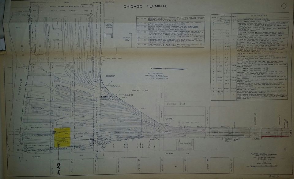 |
| Bill Archer commented on Sunny's post Attached is a photo of the ICRR Right of Way plat for the Chicago Terminal dated 1958. This is part of a book maintained by the railroad in which easements, sales and other real estate data was recorded |
 |
| Anamaria Spiteri commented on Lorri's posting Compared to...Manage |
 |
| Per my request, Paul digitally zoomed into the IC area as a comment on his posting |
 |
| David Daruszka commented on my share At one time there was a railroad swing bridge across the mouth of the Chicago River that connected the IC with the C&NW. Dennis DeBrulerYou and 1 other manage the membership, moderators, settings, and posts for Chicago Railroad Historians. And the lower deck of the Lake Shore Drive Bridge was originally planned to be a railroad connection. |
 |
| MWRD shared John Tkalec's post Looking south towards the Chicago River from North Water Street. Michigan Ave is to the right. A pick up baseball game is being played on an empty lot which is now Pioneer Court and the Apple Store. Circa 1930. |
 |
| Bill Archer commented on a posting This is a digital photo of a picture that hung in the IC B&B Shop at 18th Street. As near as I can tell it is late 1930s or early 1940s. [The comments date it between 1925 (Tribune Tower done) and 1929 (Carbon and Carbide building started).] |
 |
John Tkalec posted
1929, this area south of the Chicago River has been completely retransformed and looks nothing like this today.
|
 |
| Steven J. Brown posted South Shore trains at Randolph Street Station are exposed to the sky for the last time before the station is buried forever under Millennium Park in Chicago - November 26, 1999. |
 |
| Richard Katz posted Jeff Bransky This photo was probably taken just after the Wrigley Building south tower was completed (at least the exterior). Wrigley Building South Tower started 1920, 1921 completion. North tower completed 1924. Michigan Ave. Bridge completed 1920. Notice that the Rush Street swing bridge is still in place. It was removed soon after this photo was taken. [You can also see the Kraft plant west of Wrigley. And IC still has a big grain elevator along the river.] |
 |
Jim Arvites posted
An early 1950's view looking south of the Illinois Central Railroad freight yard in downtown Chicago taken from the Chicago Tribune Tower.
Patrick McNamara The photo I posted is dated 1952.Matthew Chapman I saw info from somewhere saying the Prude was finished in 1955. Need to check that. Patrick McNamara It was. The initial photo was probably taken from the 333 N. Michigan Avenue Building. [The Pabst sign was on Randolph.] Jim Arvetes posted
Jim Arvetes posted
Mike Halston Highly unlikely this was taken from Tribune Tower. 333 N. Michigan (built in 1929) would have partially obscured this view from 435 N. Michigan. Much more likely from the Prudential Building.What is source of this photo? Patrick McNamara Wrong. See the bridge in front of the neon sign to the far right ? That's Randolph Street - that runs right in front of the yet-to-be-built Prudential Tower. The original post photo was taken from the 333 N. Michigan Avenue building. Raymond Barr Three questions: Is that Roosevelt Road on that viaduct in the center of the photo? What is in that diamond shaped piece of land just south of the viaduct (photo left)? What is the long building with the smokestack in the center of the photo? Mitch Markovitz The first viaduct is Randolph Street. Roosevelt Road is at the top end of the visible railroad right of way. The diamond shaped area you mention is the old Monroe Street Parking Lot. The building with the stack is an Illinois Central LCL (less than carload) freight house. Paul Musselman Mitch Markovitz and imagine having to find your car in that lot on the end of a work day!!........a LOT of walking around, even just to get there... Mitch Markovitz Paul Musselman My uncle parked there every day. He got the same spot, or at least the same row and always knew where to find it. Occasional motorists tended to use the underground. |
 |
| Chuck Roth posted IC downtown yard 1980 Brandon McShane ICG was storing a lot of boxcars there before scrapping them.Brian Marra God I wish it still looked like that... Dennis DeBruler  Please skip this comment if you are interested only in railroads. Please skip this comment if you are interested only in railroads.At least they have preserved the Michigan Avenue buildings. Since the Santa Fe building has round windows across the top, it was easy to find it in today's skyline. https://www.google.com/.../data=!3m6!1e1!3m4... It looks like that black monolith was the beginning of the end. Is it the building that is now at the southeast corner of Monroe and Wabash? If so, it appears they have done some remodeling of the exterior. |
Randolph Street was the northern boundary of the no-buildings in the park rule that Montgomery Ward fought for. That rule is why we lost the Lucas Museum after we one it. This shows IC's grain elevators that were by the river and the tall-masted schooners on the river and lake.
 |
| Paul Clark posted
I found (and bought) this at the Chicago Antiquarian Map, Book, and Ephemera Fair at the Newberry Library this weekend.
It’s from Frank Leslie’s Illustrated Newspaper, August 30, 1879. The caption reads “First Annual Meeting of the National Archery Association at White Stocking Park, Chicago”
White Stocking Park was at the corner of Michigan and Randolph, basically the northwest corner of Millennium Park. The vantage point is looking north and east. Those are warehouses over the outfield wall, set among piers in what was then still Lake Michigan but today would be the rest of Millennium Park and Lake Shore Drive.
|
 |
| Historic Chicago posted Aerial view of Chicago (1922) Cropped from a photo about the Wrigley Building |
 |
| Paul Patraitis posted One of the best photos of Chicago you'll ever see, taken in 1968 by my boss, the late great Walter Krutz who shared the darkroom at CHS with me for 17 years...this tremendous panorama was commissioned by U of C Press as part of the monumental CHICAGOLAND; GROWTH OF A METROPOLIS. Taken with a large-format WIDELUX it captures the site of Ft. Dearborn as good as the Hesler photos from the 1850's...scanned from an original 8x10 silver print that Wally gave me when he cleaned out his stuff when he retired in 1985. Dennis DeBruler This view is not only the first time I have seen the north side of the Prudential Building, this is the best view I have seen of the IC freight houses. This skyline makes you appreciate that there was a breakthrough in the 1970s for building foundations in a swamp for skyscrapers. Manhattan Island is built on the remnants of a mountain range. They barely had to scratch the surface to reach bedrock. Phil Hanson It looks like the area south of the river and east of Michigan, where the IC freight houses are is below the level of the river. Is that possible or is it just an illusion? Paul Petraitis I do beleive that the easternmost tracks in the yard were at original "Chicago datum" and yes would be below the river by a little... Phil Hanson That's what I thought also. I've never seen such a clear illustration about how much the city has been raised. |
 |
| Steven J. Brown posted South Shore station at Randolph in Chicago, Illinois - February 1982. James Thornton Note F40 and gallery car set. Matt McClure James Thornton Yes, stayed for at least 3 years on the SS. Steven J. Brown posted Jason Moors By this point,the SS cars were at their decrepit end--the bilevels were a Band-Aid of sorts,decades later,the SS would have a mix of single and bilevel coaches. Albert Carello February 1982 was brutally cold and harsh |
 |
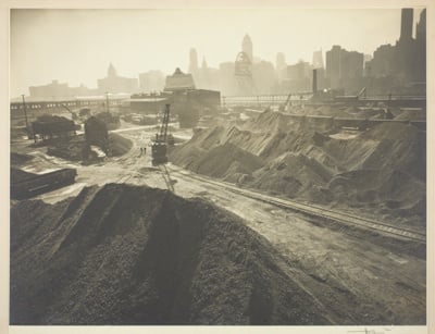
| Photo from LC-DIG-fsa-8a32937 from LOT 1073, Jul 1941 Coal dock. Chicago, Illinois |
 |
| Noach Hoffman posted A view of the coal yards that were adjacent to the river and Lake Shore Dr. in 1942. The photographer was Kenneth Heilbron and this work is in the collection of the Art Institute. William D Brown: Christopher N. Kaufmann coal fired the pumps via steam boilers until the 80s at Chicago pumping station in Mayfair. |
 |
| Photo from LC-DIG-fsa-8a32942 from LOT 1073, Jul 1941 |
 |
| Photo from LC-USF33-016114-M2 from LOT 1073, Jul 1941 Freight cars in yards, Chicago, Illinois [These are probably in the "U" formed by the IC freight house.] |
Andre Kristopans What's with the walkways above the Boxcars? So loaders could get into cars several tracks out? But if you can't get there thru the doors, why over the roofs.
Dennis DeBruler The permanently attached ones along the length of the cars are for the brakemen. Those walkways are called running boards.
https://industrialscenery.blogspot.com/.../handbrakes-and...
The walkways laid between cars are a mystery in my mind as well.
Bob Summers Dennis DeBruler my guess is so the crew that coopered the boxcars (installed the wooden doors inside the boxcar's doors) would need access before the cars were apotted to the loading tracks.
 |
| Photo from LC-USF33-016114-M3 from LOT 1073, Jul 1941 Freight cars in yards, Chicago, Illinois [I presume the lower-left corner is the roof of the east arm of the freight house.] |
 |
| John W. Barriger III Flickr, reversed and cropped |
 |
| Photo from LC-USF33-016118-M5 from LOT 1073, Jul 1941 Buckingham Fountain. Grant Park, Chicago, Illinois [Bonus photo :-). Actually, this is a reminder for me that LOT 1073 is a bunch of photos of the Chicago area taken by John Vachon for the U.S. Farm Security Administration/Office of War Information.] |
Larry Lavery posted five photos with the comment:
The rest of Chicago's Front YardDennis DeBruler shared
A southward walkabout pivoting around the Prudential building on the east side of the Illinois Central yards from Randolph Street to just past the Van Buren Street station in 1955.
Photo Credit: Clarence W. Sorensen Collection at American Geographical Society Library, University of Wisconsin-Milwaukee Libraries https://uwm.edu/libraries/digital-collections/copyright-digcoll/
In 1955 the Prudential Building was new and the tallest in Chicago. And the IC still had plenty of freight cars alongside the loop. The fourth and fifth photos are the best I have seen of Congress Street Yard.
William Lloyd The yards began to disappear late70s early 80s.
Marty Valaitis Dinner at “The Top of the Rock” on the Prudential Building was a big deal.
 |
| 1 Viewing the east side of the Prudential Building from the north sidewalk of Randolph Street near its intersection with Lake Shore Drive |
 |
| 2 Looking southwest from the south sidewalk of Randolph Street closer to Michigan avenue. The South Shore terminal is in the middle of the picture. Larry Lavery per Mitch Markovitz For the detail folk tuning in this morning...Entire train of short cars, with ex-parlor 353 or 354 making a guest appearance 4 times out from the west end of the consist. |
 |
| 3 Looking northwest from the north sidewalk of East Monroe Street. Larry Lavery Mitch Markovitz With train 19 just on its way east. |
 |
| 4 North end of Van Buren Street station with stairs up to East Jackson Drive with the Art Institute of Chicago right center on the block north of Jackson. |
 |
| 5 Van Buren St. overpass and the Van Buren Street station. |
 |
| Gail bob McCabe posted The starkness of the distance was what drew this photo to me. A magnificent structure still at 333 North Michigan Avenue from 1928. Bob [In the left middle we see the rows of boxcars in the "U" of the outbound freight house.] Joseph Gustaitis The building's name is its address: 333 North Michigan Ave. Designed by Holabird & Root, it opened in 1928 and is usually considered Chicago's first Art Deco skyscraper. It was inspired by Eliel Saarinen's unbuilt proposal for the Tribune Tower. Gregory Kurth This was the first Art Deco building to eventually influence the greatness of the Board of Trade, 135 S LaSalle and so many others. Today, many people walk by this magnificent building while focusing on other architecture on N Mich. David Lee Schwartz I don’t think this is 1928! That was during Prohibition, And the sign in the lower left is an advertisement for Seagrams Whiskies. David Lee Schwartz After looking at the photo a little closer, I’m guessing it’s more like 1933-?. The model cars aren’t as primitive as the ones pre 1920 (pre prohibition). Judging by the shadows, the pic was taken about 1-2 pm. At that hour, the streets would be jammed with traffic during the week in that part of town. So I’m guessing it was taken on a Saturday or Sunday. Even today, traffic downtown on weekends is pretty sparse, pre pandemic, so I figure it was definitely pre WW2 because gas rationing would mean practically no cars or public transit, and there’s no models that are visible from that era. Any thoughts guys? |
 |
Historic Chicago posted
The Chicago River as seen from the Rush Street Bridge (1880s)
[Michigan Ave Bridge wasn't built until 1920, so Rush was the eastern most bridge at that time. We can see IC's freighthouses and gran elevators on the south side of the river.]
|
Panorama video of Chicago lakefront with lots of boxcars in the second half (I contributed some posts as to why there were so many boxcars on the lakefront.)
Photos of the early impact of the IC along all of the lakeshore.
VintageChicago aerial
LTL Shipping Chicago IL Thanks for a very interesting blog. What else may I get that kind of info written in such a perfect approach? I’ve a undertaking that I am simply now operating on, and I have been at the look out for such info.
ReplyDelete