I've seen references to the 1937 Flood before. For example, this flood is what triggered a lot of levees being built or improved along the Mississippi and Ohio Rivers. But I think this is the first time of seen pictures of it. And two different postings in one week.
 |
Illinois Central Railroad Scrapbook posted
During early January, 1937, the Ohio River began flooding. At first, forecasters and residents weren't too concerned because it is not uncommon for the river and its tributaries to flood in the winter and springtime. But this time the water kept rising, and rising, and rising. On January 22 the IC halts freight and passenger train service into Paducah. That same day the locomotive shops in Paducah closed, but the Paducah hospital remained open (however, the hospital did eventually close a few days later)
The flood crest at Paducah was reached on February 2 when the flood gauge reached 60.8 feet, or 6.5 feet higher than the previous record. The flood waters receded slowly and the shops did not reopen until February 12. Partial train service into Paducah resumed on February 13 but the "Mud Line" between Paducah and East Cairo, which runs in close proximity to the Ohio River, remained closed until February 25.
This photo was taken by an IC company photographer and shows the height of the flood. The shops and roundhouse are prominently visible, while the IC's hospital is barely visible to the left of the shops, one block over (look closely and you can see the smoke stacks at the hospital).
Cleaning railroad property took several weeks. Virtually every machine at the shops had to be disassembled, cleaned, and reassembled. Tons of debris had to be hauled away from the tracks, and countless cars and locomotives had to be cleaned.
Incidentally, the flood affected not just the Ohio River but also all of its tributaries. At Gilbertsville the flood waters came within a foot of reaching the tracks on the drawbridge across the Tennessee River. Creeks and streams far away from the Ohio River flooded, causing problems all across the Ohio River valley. Several deaths were reported, but there is no definitive answer. Some sources state there were as few as 15 deaths, while others say there were over 100.
My mother and father came to Paducah in 1936, dad was a machinist at the IC shops. They endured two weeks of the 1937 flood before being evacuated, they were sent back to Sedalia, Mo. and returned to Paducah in 1939 when the shop was reopened.
|
Paul Echols
posted two photos with the comment: "
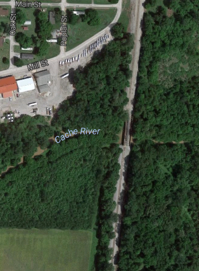
These photos, while not high quality, capture the flood waters on the ICRR at Ullin, IL during The Great Flood of 1937. This flood was during January and February 80 years ago. The bridge is the Cache River Bridge on the south edge of Ullin. The cars were placed on the bridge to hopefully keep it from floating off its foundation. The bridge did survive."
My mother was 13 years old in 1937 and lived in Cairo. So I heard the stories many times. All women and children were evacuated from Cairo by way of the ICRR, while the men were forced to stay in town and help sandbag the levee. My grandfather, a WWI veteran stayed (there is a whole another story to how they saved Cairo). My mother remembered boarding the ICRR passenger train to go north with her sisters and mother. She also remembered men dressed as women being caught and being thrown off the train! As they went north to Carbondale, she recalled passing through Ullin and looking out--not realizing she likely saw the house where she would years later raise her own family (our home place is about 150' away from the Mainline). She was then taken by ICRR again to Murphysboro where she stayed with other evacuees for a few weeks before the river receded. This is all part of our family history linked to the ICRR. By the way, the Ullin ICRR Depot (I helped others save it and routinely post photos here) was able to stay dry in 1937--but just barely. Many evacuees sought refuge there waiting for a train to come through the flood waters to rescue them. I have been told by older citizens that a couple of babies were born in that depot during those days. I wrote a history about the Ullin ICRR Depot and successfully presented the history to gain recognition on the National Register of Historical Places back in 1997 on the depot's 100th anniversary.
 |
Illinois Central Railroad Scrapbook posted
On February 2, 1937, the Ohio River finally crested at Paducah, KY, at 60.8 feet. This flood crest was 6.5 feet higher than any previous recorded flood at Paducah (and thankfully hasn't been equaled since).
Back on January 22 the IC had suspended passenger and freight service into Paducah, and the locomotive shops closed that same day. The shops reopened on February 12, and partial train service resumed on February 13.
This aerial photo of IC's Paducah shops isn't dated but is thought to have been taken around February 3. The locomotive erecting/machine shop is to the left, and the boiler shop (with its vertical boiler riveting bay) is to the right. Barely visible on the far right is the tank/paint shop. The 36 stall roundhouse is in the center, and in the far background is downtown Paducah and the Ohio River.
There was a load of teak and mahagony timbers, in the RR yard at the time of the flood, that floated off into adjacent yards and were subsequently used in future building projects.
During the 1970s or 80s, some of this was in the front yard of a house being remodeled, on the Old Mayfield road, near Guthrie Avenue.
It was being sold as scrap lumber for a VERY reasonable price.
An amatuer furniture maker bought it all, but gave the seller more than they were asking because they had NO IDEA how valuable those large and heavy timbers were.
I live a half mile from the ICRR yards and, as I was demolishing a house next door to me, found a heavy/thick timber that had been part of a wooden RR car, half buried in the ground and being used as a back porch step.
I suspect it had floated there during the flood, as the water level had been about eight feet deep, in my yard.
I still live in the house that was about ten years old at the time of the flood.
Corky. They have the high water mark on a plaque in the shop it is unreal!
|
This is an example of how even small creeks rather far away from the Ohio swelled way out of their banks.
 |
| 1 |
 |
| 2 |
I checked a 1938 photo to confirm the reason we don't see many trees poking out of the waters in the above photo is because there were not as many back then. It looks like the farmer quit farming the flood plain. And some sort of mining operation on the north side of the river has been abandoned.
Illinois Central Railroad Scrapbook
posted three photos with the comment:
During early January, 1937, the Ohio River began flooding. At first, forecasters and residents weren't too concerned because it is not uncommon for the river and its tributaries to flood in the winter and springtime. But this time the water kept rising, and rising, and rising. On January 22 the IC halted freight and passenger train service into Paducah. That same day the locomotive shops in Paducah closed, but the Paducah hospital remained open (however, the hospital did eventually close a few days later)
The flood crest at Paducah was reached on February 2 when the flood gauge reached 60.8 feet, or 6.5 feet higher than the previous record. The flood waters receded slowly and the shops did not reopen until February 12. Partial train service into Paducah resumed on February 13 but the "Mud Line" between Paducah and East Cairo, which runs in close proximity to the Ohio River, remained closed until February 25.
Areas downstream were not spared the flood's wrath. Train service through Mounds, IL, (on the IC's north-south mainline) was halted January 27 and did not resume until February 12. Flood waters eventually stood nearly 4 feet deep in the yard at Mounds.
Cairo, IL, where the Ohio River flows into the Mississippi River, did not flood, thanks to a levee system that had been extended in length and raised in height several months before the flood. The levees provided protection to a height of 60 feet on the Ohio River gauge. The Ohio River crested at 59.62 feet on February 4. However, the IC had to stop train movements into Cairo on January 27, and train movements stayed suspended until February 12.
In between the Ohio River bridge at Cairo and the town of Wickliffe, KY, the IC mainline and the parallel GM&O run through "the bottoms", a swampy area that parallels the Ohio and Mississippi rivers. Approximately six miles of trackage along this stretch were submerged. At several spots the flood waters were five feet deep. Nearly 3,200 feet of track was destroyed when the embankment under the tracks was washed away. Train service here was suspended between January 23 and February 15.
Cleaning railroad property took several weeks. Virtually every machine at the shops had to be disassembled, cleaned, and reassembled. Tons of debris had to be hauled away from the tracks, and countless cars and locomotives had to be cleaned.
Incidentally, the flood affected not just the Ohio River but also all of its tributaries. At Gilbertsville the flood waters came within a foot of reaching the tracks on the drawbridge across the Tennessee River. Creeks and streams far away from the Ohio River flooded, causing problems all across the Ohio River valley. Several deaths were reported, but there is no definitive answer. Some sources state there were as few as 15 deaths, while others say there were over 100.
IC photos, Cliff Downey collection.
 |
| 1 |
 |
| 2 |
 |
| 3 |
Bill Stroud
posted three photos with the comment: "H
ere are some pictures of the 1937 flood in New Albany"
 |
| 1 |
 |
| 2 |
 |
| 3 |
 |
John Steele posted
I found this in a group of photos on the 1937 flood in Evansville, IN. I don't know any information. But thought it was an interesting photo.
[Unfortunately, he did not provide a link to the flood photos.] |
Flood Walls
Some examples of flood walls that have been built since then are below. Also, a lot of dams have been built on the tributaries to keep the water from reaching the Ohio River. For example,
Rend Lake did not eixst in 1938.
Ohio River: New Albany
 |
Bill Stroud posted
New Albany Flood Wall construction 1953 |
Ohio River: Paducah
I'm saving satellite images because I noticed they caught the Ohio River at a significantly high level.
 |
| Satellite |
I use the birds-eye view to illustrate the normal 9-foot channel navigation level maintained by the dams. When we visited, we not only drove on "The Foot of Broadway," the parking lot was clear of water. That little boat was going back and forth along the shore. We never did figure out why.
Ohio River: Brookport
Ohio River: Cairo
 |
| The river side of that wall |
I remember it was in the news that the Corps of Engineers blew out a levee south of the Ohio River confluence to flood Missouri farms and provide another channel for the Mississippi waters to keep the Ohio River level below the top of Cairo's flood wall. This sounds cruel to the farmers until the news reports explained that the Corps pays the farmers each year for the right to flood their land if needed. Looking at
a satellite image, US-62 is built on top of an embankment most of the way to Wyatt, MO. And there are no towns
between MO-72 and the river.
 |
| Cairo's wall down by the CN/IC bridge. Note the wall is built on top of a levee. |
 |
I did not realize the railroad functioned as a levee until I saw this massive 1914 flood gate north of the track embankment.
"The gate itself weighs 80 tons, is 60 ft. wide, 24 ft. high and 5 ft. thick." [BridgeHunter] |
Wabash River: Mount Carmel
 |
| 20160107 7571, cropped, the wall is on the right side, Mount Carmel |


No comments:
Post a Comment