Thursday, November 21, 2024

1896+1955+1991 US-54+US-63 Senator Roy Blunt Bridge over Missouri River in Jefferson City, MO

1896: (Archived Bridge Hunter; Satellite, south abutment of lost bridge.)
1955+1991: (Archived Bridge Hunter, no Historic Bridges; Satellite, 174 photos)

BridgeHunter_1896
This color postcard shows automobiles crossing the bridge.

BridgeHunter_1896
Flood of 1903
This historic photo was submitted by Wayne Johnson. He explains, "It was taken from the dome of the Old State Capitol during the crest of flood stage of the flood of 1903. The view is looking Northwest into Callaway County toward Boone County. This Capitol Building burned to the ground in 1911 and was replaced by the current capitol building in 1913-1918."

BridgeHunter_1896
Photo taken on Opening Day by B.F. Oliver of Oliver Photos. (Photo from the collection of Richard Oliver Snelson, the grandson of the photographer)

shsmo via search, cropped

Photo via BridgeHunter_1896

cdm_164
July 20, 1951: Bridge over Mississippi River, Hannibal, Marion County

cdm_201
April 27, 1952: Route 63 and bridge over Missouri River during flood

Missouri State Archives Flickr
MO Bridges - Old Jefferson City Missouri River Bridge
Collection Name: RG107 Missouri Department of Transportation Photograph Collection
Photographer/Studio: MoDOT Staff
Description: View of the old Missouri River bridge in Jefferson City with ice on the river. This bridge was demolished in 1955 in favor of a larger structure.
Coverage: United States - Missouri - Cole County - Jefferson City
Date: 01/03/1951
Rights: public domain
Credit: Courtesy of Missouri State Archives
Image Number: modot_256A_002.tif
Institution: Missouri State Archives
 
Evidently, the WabackMachine archived the entire video because, when I tried to access it directly on YouTube, I got a "not available" notice. I kept shoving the slider until I found a truss construction scene.
39:47 video

VintageColePhotos, this webpage has a history of the bridge
Architect's Drawing of the Proposed Bridge at Jefferson City
.

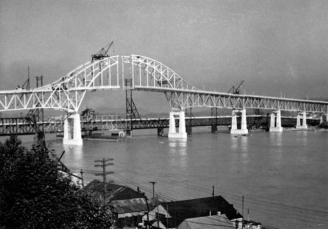
1955+1991 Bridge


Missouri State Archives Flickr
MO Bridges - Jefferson City Missouri River Bridge
Collection Name: RG107 Missouri Department of Transportation Photograph Collection
Photographer/Studio: MoDOT Staff
Description: View of new Missouri River bridge from the north side of the River, State Capitol building in background. The bridge opened in 1955.
Coverage: United States - Missouri - Cole County - Jefferson City
Date: 10/26/1956
Rights: public domain
Credit: Courtesy of Missouri State Archives
Image Number: modot_1470_005.tif
Institution: Missouri State Archives

This 3124' (952m) long bridge has a main span of 596' (182m). [BridgeHunter_1955+1991]

Randall Perkinson Photography posted seven photos with the comment:
Senator Roy Blunt Bridge
US-54 and US-63 over the Missouri River
Jefferson City, Missouri, USA 
The Senator Roy Blunt Bridge is a pair of continuous arch truss bridges.  The westbound bridge was designed by Sverdrup & Parcel in St. Louis, constructed by Stupp Brothers Bridge & Iron Company, and opened to traffic in 1955.  It carried one lane in each direction plus a reversable lane in the center.
Due to traffic growth, the eastbound bridge was opened in 1991 and though originally designed to carry 3 lanes of traffic, it has been striped to carry 4 lanes of traffic.
In 2011 a new bicycle and pedestrian walkway was cantilevered off the downstream side of the eastbound bridge to connect Jefferson City with the Katy Trail.
I hope you enjoy these images taken from various viewpoints.
1

2

3

4

5

6

7

The approach for the new bike trail addition:
BridgeHunter_1955+1991

TheMissouriTimes
The name was changed from Jefferson City Bridge to Senator Roy Blunt in 2022.


1931,1989 OH-82 and 1882,1992 Station Road Bridges over Cuyahoga River at Brecksville, OH

1931 Arch: (Archived Bridge Hunter; Historic Bridges; HAER; Satellite)
1882 Truss: (Archived Bridge Hunter; Historic Bridges; HAERSatellite)

The pin-connected truss bridge is the Station Road Bridge and the concrete-arch bridge is the Brecksville-Northfield High Level Bridge. The railroad on the left is a tourist railroad, Cuyahoga Valley Scenic RR.
Paul P, Mar 2017

This is the station that Station Road connected to the towns on the edges of the valley. We can see part of the Station Road Bridge on the right side of this photo.
Harrison Whittaker, Oct 2022
 
HAER OHIO,18-BRECK,3--1
1. GENERAL VIEW, SHOWING THREE SPANS OF BRIDGE, FROM SOUTH - Brecksville-Northfield High Level Bridge, Spanning Cuyahoga River Between Brecksville & Northfield, Brecksville, Cuyahoga County, OH

HAER OHIO,18-BRECK,4--5
5. Telephoto view of bridge showing Brecksville-Northfield High Level Bridge in background - Station Road Bridge, Spanning Cuyahoga River, Brecksville, Cuyahoga County, OH

"Significance: Built by the Madison Massillon Bridge Company, the bridge represents a comparatively rare example of a double intersection Pratt truss. The bridge is 128.6 feet long and 18.7 feet wide. It served as an important vehicular connection between Summit and Cuyahoga counties until the construction of the nearby Brecksville-Northfield High Level Bridge, which opened in 1931." [HAER_truss_data]

The trail in the lower-right corner was the towpath of the Ohio & Erie Canal.
Bruce Butkus, Aug 2017
 
HistoricBridges_1882
"This rare Whipple truss bridge displays the unique Howe truss portal bracing of the Massillon Bridge Company. The bridge has been preserved in its original location for pedestrian use, the former highway now being a trail in a national park."

The concrete arch bridge has five spans. 
Street View, May 2024

Ben H, Sep 2016

Ikbal Hossain posted without giving proper credit to Michael Murray.
A rare view of the Cuyahoga River at the Station Road Bridge Trailhead in Cuyahoga Valley National Park. I think there’s a bridge too if you can spot it. The fisherman is more obvious. And someone finding his or her way on the Towpath in the distance. 😀
[Some comments point out that this is not a rare view. One comment claims it is AI generated.]

Don Ballasch commented on Ikbal's post
Was a great fishing spot till the water dropped 5 feet.
[Some additional comments indicate that some dams were removed.]

Jim Karas commented on Ikbal's post
Lovely

Dennis Szulinski commented on Ikbal's post

Wednesday, November 20, 2024

OK-199 1950,2019 Bridges over Cumberland Cut for Washita River

(Archived Bridge Hunter; no Historic Bridges; Satellite)

"The Cumberland Cut is a man-made channel of the Washita River. This bridge was erected from re-used spans circa 1950....Open to pedestrians only. Bypassed and retained in place per ODOT." [BridgeHunter]

It was bypassed in 2019. [Nathan Holth comment on BridgeHunter]

Street View, Jan 2014

Bridges Now and Then posted
"OK 199 Washita River, Bryan Co.
Cumberland Cut Bridge." (Oklahoma Bridges)

okbridges
"Built in 1950, the structure appears to have been constructed entirely of reused spans, including a 210-foot long pin-connected Parker through truss that appears to have been widened....Total length of structure from abutment to abutment is 538 feet, deck width is 22 feet." The Parker truss is "the longest pin-connected truss bridge on the state highway system"

The pin-connected Parker truss.
Street View, Jan 2014

1954+1979 I-77 C.H. Charlton Bridges over Bluestone River

Both: (no Historic Bridges; B&TSatellite, 202 photos)
1954 SB: (Archived Bridge Hunter) rehabilitated 1983

Boston Public Library Flickr via BridgeHunter-1954, License: Creative Commons Attribution (CC BY)
Also wvhistory

Was the above colorized postcard based on this photo? "The Charlton Memorial Bridge towers 246 feet over the Bluestone Gorge." [wvhistory]

1 of 4 photos posted by Bridges & Tunnels
The Charlton Memorial Bridges carry the West Virginia Turnpike and Interstate 77 over the Bluestone River in Mercer County, West Virginia.
A 35-mile segment of the new West Virginia Turnpike from Princeton to Beckley—and a major bridge over the Bluestone River in Mercer County, was dedicated on September 2, 1954. It was dedicated to Sgt. Cornelius Charlton, a World War II hero from East Gulf who was awarded the Congressional Medal of Honor posthumously.
Studies were undertaken to upgrade the Turnpike in the early 1970s, and work to upgrade the highway to four lanes had commenced because of escalating traffic counts and congestion, and because of a high number of accidents. The update was also needed because of the proposal to route Interstate 77 over the Turnpike. A parallel bridge to the original Charlton Bridge for northbound traffic was completed in 1979, and the original circa 1954 Charlton Bridge was rehabilitated in 1983.
➤ Check out more from the Charlton Bridges at

Jul 2016 Photo by Royce and Bobette Haley via BridgeHunter-1954
Looking North-Background span is SB
[The older truss is a lot deeper than the newer one.]

Richard Hurd Flickr, License: Creative Commons Attribution (CC BY)
C.H. Charlton Bridge, WV Turnpike, 07-19-2014 2118
The Charlton Memorial Bridge over the Bluestone Gorge on the West Virginia Turnpike on a misty July morning in 2014
 
zaubee

It is nice to see that it has a fresh paint job.
Street View, Jul 2022

Although it was needed.
Street View, Jun 2011


Tuesday, November 19, 2024

Old Guard Gate and Lost Bridges #7 and #9 on Welland Canal

Guard Gate and Bridge #9: (Satellite)
Bridge #7: (Satellite)

Michel Gosselin posted three photos with the comment: "The old guard gate above lock 7 in Thorold on September 15, 2024."
1

2

3

Derrick Thornbury commented on Photo 1
Here's a photo of it I took in May 2005 from the paper mill...

Michel Gosselin commented on the above post
It was used to regulate water levels and could be closed if a ship took out the lower gates of lock 7, thereby stopping a flood of the lower part of the canal and surrounding areas. They didn’t need this because they put a guard gate at lock 7.

I think these secant gates are the current guard gates. I noticed them when I wasl looking for the former location of Bridge #7.
Satellite
.

Bridge #9


This shows Bridge #9 operating. The road across the gates and the bridge was replaced by the Thorold Tunnel.
brocku, cropped

JD Holmes commented on the above post
Found this one online.
Rick Plato: JD Holmes that pic shows it back when it was the road connecting N.F. to Thorold, prior to the tunnel.
.

Bridge #7


Historical Niagara posted four images with the comment: "Many take the Thorold Tunnel daily but before the 1960s  you had to take a Bridge to cross the Canal Bridge #7 THE PETER STREET BRIDGE was replaced by the Tunnel along with Bridge #9 at the Paper Mill..This was a Bascule style and was used a lot on the Canal ..a few still remain .."
Peter D. A. Warwick: Bascule bridge are actually the most common type of bridge on the present canal. Originally there were 9 such bridges, if you count the ones at Homer as being a double bascule. If you look under the bridge you'll see that they are the same design as the others only instead of having the deck at the bottom they have it on top making them also a draw bridge. Today there are 8. The two newest raised bridges on the canal are bascule: Carlton Street in St. Catharines built about 1968 to replace an earlier bridge that was damaged by a boat hitting it and Mellanby Avenue in Port Colborne, which I don't know when it was built. My guess would be the 1980s or 1990s. There were originally 10. Today only 3 remain. There were originally 2 swing bridges. Today none remain.
1

2

3

4