Showing posts with label rfLalich. Show all posts

Sunday, March 13, 2022

BNSF/Santa Fe Bridge over Des Plaines River in Lyons, IL

(Satellite, BNSF/Santa Fe is the southern bridge. The northern bridge is the C&IW)

ATSF Des Plaines River 4/87
This is the site of the original Chicago Portage which enabled small boats and canoes to go between the Great Lakes and Mississippi water systems. This geographic feature is the reason Chicago became a great transportation center.
 
MWRD posted on Oct 26, 2022
A view of the newly built Santa Fe Railroad bridge over the Des Plaines River between Lyons and Forest View with a passing train "...running full speed" on April 13, 1899.

Andy Zukowski posted
Santa Fe tracks near Lyons, Illinois overflowed by the Des Plaines River 1909

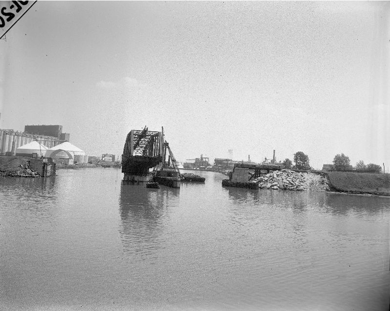
MWRD posted on Mar 4, 2022
Construction of the Santa Fe Railroad bridge over the Des Plaines River between Lyons and Forest View on November 15, 1898. The bridge was one of many the Sanitary District (now MWRD) built during construction of the Chicago Sanitary and Ship Canal. 

From the 47th Street Bridge, the Santa Fe Bridge is obscured by the C&WI Bridge.
Street View

HalstEd Pazdzior posted, this photo has been moved to
"BNSF/Santa Fe Bridge over Des Plaines River in Lemont, IL."


Friday, August 14, 2020

Lost/Pennsy/Calumet Western Bridge over the Calumet River

(Bridge Hunter; Satellite, the bridge was wrecked by an ocean-going ship in 1962)

Rod Sellers posted
Where am I?

Rod Sellers commented on his post
Answer: Calumet and Western RR swing bridge across the Calumet River east of Torrence Avenue. Beyond this bridge there are 2 bridges in view the Calumet and Western Indiana RR single leaf bascule bridge and Torrence Avenue vertical lift bridge. The NY, Chicago and St Louis RR (Nickel Plate) swing bridge is a little further up the river and is not visible in this photo. In the early 1960s when the Port opened at Lake Calumet the federal government wanted all three of these railroad bridges replaced as hazards to navigation. Two were replaced with vertical lift bridges. the Calumet and Western RR bridge was torn down and never replaced. Attached aerial photo [see above] shows view from the west.


Bob Lalich Flickr Photo

calumet river proposed straightening

Aerial view of navigation obstacles in the Calumet River at Torrence Avenue.


Marty Gatton shared


Bob Lalich commented on Rod's post
The Calumet Western swing bridge was removed after it was hit by an ocean-going ship in 1962. Here is the bridge shortly after the accident.

Bob Lalich Flickr

calumet western bridge damaged 5-15-62

Calumet Western RR swing bridge over the Calumet River sits askew after being struck by a ship in 1962. The CW was jointly owned by PRR, CRI&P and IHB. Arrangements were made to use the adjacent C&WI bridge after the accident. The swing bridge was dismantled and never rebuilt.


Marty Gatton shared


Marty commented on his share
From Rod Sellers


Dennis DeBruler commented on Rod's post
It is interesting to see how long it takes for a change to be reflected in the USGS maps. Bob Lalich has commented that the bridge was damaged by an ocean-going ship in 1962 and the route was changed to share the C&WI bridge. But the bridge still appears in this 1965 topo.
1965 Lake Calumet Quadrangle @ 1:24,000

Dennis DeBruler commented on Rod's post
The purple lines show the new tracks that were laid to allow the Calumet Western to share the C&WI Bridge.
1973 Lake Calumet Quadrangle @ 1:24,000
IHB continuing the operation of the Calumet Western explains why it bought the bridge when the C&WI abandoned this branch to Indiana.

When Calumet Western started using the C&WI bridge, they still had their Strauss trunnion bascule bridge.

A 1984 Bob Lalich Flickr photo
C&WI Mainline Bridge
The MP Hammond local passes over the C&WI Mainline bridge over the Calumet River, 8-84. 
Bob Poortinga 6y 
It is interesting that at this date, the C&WI uses one track on the bridge and the Cal Western uses the other.
Bob Lalich 6y 
This was after NS had acquired the C&WI between SL and 81st St. They quickly removed track 1 between SL and 110th St. Track 2 was removed when the Hammond Times moved the printing plant to Munster.
Bob Lalich 3y 
The CW connection to the C&WI was established after the CW swing bridge was hit by a ship in 1962. Here is what I have pieced together from various sources. Even before the CW bridge accident, plans had been drafted to replace the CW and C&WI bridges with a lift bridge in order to aid navigation in light of ocean-going ships using Lake Calumet harbor after opening the St. Lawrence Seaway. Replacing the NKP swing bridge was also part of the overall plan. It was decided not to repair the CW bridge after the 1962 accident, even though it would be years before the new bridge could be built and RoW obtained for the connecting track on the south side of the river. C&WI granted trackage rights to the CW between 123rd and 126th in 1964. I believe a temporary connection was established from the C&WI main south of the river to industrial trackage just to the east. A connection north of the river was built as well. This arrangement lasted until the lift bridge was opened in 1971. The C&WI lift bridge and the Torrence Ave bridge had separate operators.

Larry Candilas posted five images with the comment: "This is for those recently interested in the Calumet and Western swing bridge just downriver from the C&WI bridge."
Gary Siatka: The Calumet swing bridge had been struck by ships a few times. They rerouted to the CWI. This required the removal of roughly 10 houses
1

2

3
Randy Bosma: Note the "C&O Ry, of Ind." from/to Hammond. That's also known as the Hammond Belt Line RR. Very short lived; it was gone by the mid-1920s.

4

5

Larry Candilas commented on his post
Late 1930s

1 of 6 photos of the C&WI bridge posted by Larry Candilas


Wednesday, January 22, 2020

UP/C&NW Rockwell Junction (Wye)

(Satellite)

(Update: the west end of the wye is controlled by Kedzie Tower.)

John Morris posted
[There is much more info on this posting below. To summarize that information, this is looking south at a compass northbound (timecard westbound) train that has taken the west leg of the Rockwell Junction Wye.]
On a contemporary satellite image it is easy to see the two legs of the wye because all of the other tracks have been removed.
Satellite
For decades Pennsy's Panhandle had tracks next to the east leg. Multiple sources think the tracks that used to be inside the wye were a yard for the Panhandle. Other sources think the tracks were C&NW's South Yard. The tracks that still exist above the mainline were the North Yard. My conclusion is that the west track on the east leg was owned by C&NW and that the land now used by Sims Metal Management was C&NW's South Yard. In fact, Bob Lalich identifies the yard as a C&NW freight yard.

In fact, this C&NW freight yard was the interchange with Pennsy. [Position-Light, Part 1, source]
Metra via Position-Litght, Part 2 and a Tower A2 Album
[This confirms the yard and the west track of the east leg was C&NW.]

I include the CTA's Green Line at the bottom because that is the truss bridge in John's photo.
1929 Chicago Loop Quadrangle @ 1:24,000
This photo copied from the C&NW Passenger Yards notes
WW2 Radio post, #28
Timothy Pitzen David Daruszka, if I remember correctly, the yard to the right, or south, of the C&NW main was the Pennsy coach yard. Also, the haze may be exaggerated by the old style film which was more sensitive to blue wavelengths which tends to accentuate haze.
Dennis DeBruler I always wondered where the Panhandle yards were.
David Daruszka The Sanborn maps show Panhandle freight yards as being in the area between the Rockwell Jct. wye. There were also yards closer to downtown adjacent to the Milwaukee Road tracks. The Panhandle had a freight house at Sangamon Street.
Bob Lalich The yard south of the CNW main tracks was a CNW freight yard.
Another aerial photo that includes the junction.
29
David Daruszka C&NW California Ave. Coach Yard. Milwaukee Road tracks and yard to the left. C&NW's Rockwell Branch is above the Coach Yard.
Harvey Kahler Both Rockwell and Panhandle (PCCC&StL) head off top right (south).
David Daruszka This was also the route, for a brief time, for the B&O passenger trains when they left Grand Central and moved to the C&NW's Madison Street Terminal.

I include the information on the post in a raw form because it is an example of a positive use of social media. As someone said, the bee hive is smarter than any bee. Note that not only was the location of the photo determined, but the train itself and the now removed Pennsy Panhandle tracks were discussed. Below the Facebook screenshots are higher resolution copies of the images.

1

2

3

4

5

6

David

Bob

Dennis

Dennis

Bob

Dennis

Patrick

Dennis

Bob


Tuesday, January 7, 2020

Former Lake Side Sand and Gravel

Satellite

Dennis DeBruler shared the following Flickr link with the comment:
What was the name of the Pennsy tower that we can see in the background under the Skyway?
https://www.flickr.com/photos/46264216@N08/6617170975/in/photostream/
BTW (by the way), the foundation for the yard office still exists because it is part of the embankment wall.
Bob Lalich There is a good chance that the photographer knows the answer to your question Dennis DeBruler. The green structure is a sand tower that is still standing on the west bank of the Calumet River, just north of 95th St. The business was called Lake Side Sand & Gravel. They have been out of business for some time.
Bob Lalich Flickr, Oct 1994
BRC Commercial Ave Yard
A CSS transfer has just cut off from its train and passes the old BRC Commercial Ave Yard office in South Chicago, 10-94.

3D Satellite
I checked my photos that I took in this area when I did a field trip to get bridge and CSL photos. Some of the overview shots were close to including this tower. But, alas, none of them did.

I wonder if Compass Minerals has expanded and now uses the land because the above satellite image shows a couple of active piles south of the Howard Slip. And this is some of the material handling equipment I spotted on the land.
3D Satellite

And in this street view of the tower, there is a covered pile on the land.
Street View
In fact, there were more covered piles. But I can't tell for sure if the piles are north or south of Howard Slip.
Street View
Is this whole area built on beach sand? I assume these piles on the sidewalk and 95th Street were caused by erosion during a rainstorm. I can't imagine someone would dump sand on a sidewalk and street.
Satellite