Showing posts with label wwKentucky. Show all posts

Wednesday, December 4, 2024

1842 Kentucky River Lock and Dam #5 near Lawrenceburg, KY

(Satellite)

While studying the Young's High and Tyrone "S" Bridges, I noticed this lock and dam on the satellite map.

This dam was built in 1842 as part of the Kentucky River Waterway. It was rebuilt in 1886 and closed in 2006. [AbandonedOnline]

nara, Public Domain

I can't correlate this photo with the satellite image. This photo looks like a dam removal project. When I did a Google search for this dam, I didn't get much for this dam. But I did get a lot of results concerning the removal of L&D #5 on the Green River. This photo does match the photos in EdmonsonVoice. I think Carol uploaded to the wrong river.
carol bledsoe, Jul 2021

When I got an image of the Young's High Bridge, I thought the river level was rather high.
Street View via Dennis DeBruler

So I looked at some other dates, and I was puzzled because the river always seemed to fill its banks. This view was about the lowest river level I could find. Dam #5, which is just downstream from this bridge, explains why the river always looks high. If they ever do remove this dam, then Young's Bridge will finally be higher than the Cincinnati Southern's High Bridge of which they planned to beat by 6" but missed it by 12".
Street View, May 2019

Friday, December 22, 2023

I-75+US-25 Clays Ferry 1869+1946+1998 Bridges over Kentucky River south of Lexington, KY

Old: (Bridge Hunter broke May 22, 2023; Historic BridgesSatellite)
The 1998 bridge replaced the truss of the 1946 high-level bridge [HistoricBridges_new]
New: (Bridge Hunter broke May 22, 2023; Historic Bridges; B&TSatellite)

The new bridge viewed from the old bridge:
Street View, May 2023

The old bridge:
Street View, May 2023

1869 Bridge:
HistoricBridges_old, Source: Kentucky Digital Library
[Historic Bridges gives this bridge its highest rating of 10/10 for both National and Local significance..]
This 1869 bridge has cast iron truss members. And the Warren truss is pin-connected. "Warren trusses usually have riveted connections.....The bridge was built in 1869 for the Richmond and Lexington Turnpike. The bridge was purchased by the State of Kentucky in 1929 and became part of US-25 until a larger high level bridge was built to realign US-25 in 1946. Since then, the cast iron truss has carried local traffic only. The bridge was rehabilitated in 1955. At some point, the top of the pier was removed and replaced with concrete. The primary substructure material is stone, although concrete has been used to repair the abutments as well."

HistoricBridges_new

Bridges Now and Then posted and kyphotoarchive_1944
"The Clays Ferry bridge was under construction over the Kentucky River in November 1944. The task of laying superstructural steel work on the pylons was done by the Mount Vernon Bridge Co. of Mount Vernon, Ohio. The structural work was started from the Fayette County side of the river and rose at a three percent incline to the Madison side. This slight grade can be seen in the photo. The bridge was 280 feet [85m] high at river level, the highest structure of its kind east of the Mississippi River at the time, and was more than 1,500 feet [457m] long. Published in the Lexington Leader." (Kentucky Photo Archive)
[You can see the old truss in the background.]

HistoricBridges_new explains that a parallel bridge was added in 1963. Then in 1998, when they replaced the trusses, they added the solid center piers and turned two 2-lane bridges into one 6-lane bridge.
Street View, Apr 2023

kyphotoarchive_1989, photo by Charles Bertrarn
"The bridge on the right was built in 1946 as a link over the Kentucky for U.S. 25. The bridge at left was added in 1963, and the two bridges became part of I-75."

HamburgJournal
"The Clays Ferry overlook wall was built in 1934, as a scenic overlook on the Old Dixie Highway."
The bridge is 250' (76m) above the Kentucky River.

1 of several photos on Bridges & Tunnels
Construction started in 1941, but it was slow because it competed with the war for steel and workers. In 1944, only 20 employees were working on the bridge.
[This webpage has a detailed history of the bridges.]

Salma Moli posted
Construction of Clays Ferry (Kentucky) bridge (1-75)

B&T mentioned that the old bridge is just one lane, so I took a closer look. That is quite a bit of traffic for a one lane bridge.
Street View, May 2023

April 2025 Flood:
Facebook Reel

Facebook Reel

Tuesday, May 30, 2023

1929 NS/Sou/CNO&TP/CS over Kentucky River at High Bridge, KY

([I could not find an entry for this bridge in Bridge Hunter]; B&TSatellite, 207 photos)

To explain the title, Cincinnati built and owns the Cincinnati Southern route, but it now leases it to the Cincinnati, New Orleans & Texas Pacific (CNO&TP), which is a wholly-owned subsidiary of Norfolk Southern.

The previous bridges, 1877+1911, are documented here.

OnlyInYourState, Wikimedia/Rsfinlayson
"High Bridge opened as a part of the Cincinnati Southern Railway in 1877 and soared at a height of 275 feet and 1,125 feet long. Over a century later and the bridge continues to stand as one of the tallest and most impressive in Kentucky.
"At the time it was built, High Bridge was the tallest bridge above a navigable waterway in North America and the tallest railroad bridge in the world until the early 1900s."
Kentucky Living Magazine posted
On this day in 1877, workers completed High Bridge, connecting Jessamine and Mercer Counties over the Kentucky River Palisades. It was the tallest bridge above a navigable waterway in North America (275 feet) and the tallest railroad bridge in the world until the early 20th century. The bridge was rebuilt in 1911 and is still used today by Norfolk Southern Railway to carry trains between Lexington and Danville. It has been designated as a National Historic Civil Engineering Landmark.
C Kent McKenzie shared
Norfolk-Southern...
Kentucky Colonels - National Headquarters posted (source)
In 1877, the first cantilever bridge in the United States was completed in Harrodsburg, Kentucky. This railroad bridge crosses the Kentucky River Palisades, connecting Jessamine and Mercer counties. A cantilever bridge is a bridge whose main elements are cantilevers (structures that are anchored at only one end while the other projects horizontally into space). #KyHistory
Kenny McLaughlin Also known as High Bridge, the oldest highest bridge in the US still used! I’ve sat in the middle of that bridge with two friends with our legs hanging over the side holding on for dear life while a train and many cars went over it at about 40 mph. That thing flexes and shakes while that train crosses it ! It’s so high you can’t imagine how it was built! Those were the days!
Bill Johnson That's actually the second bridge. In the early 1900s, the new bridge was built around the old bridge and the elevation was raised. Later, it was made a double track bridge.
 
Bridges & Tunnels posted
High Bridge spans the Kentucky River near Wilmore, where the gorge drops nearly 300 feet to the valley floor. Completed in 1877 and rebuilt in 1911, it was the first cantilever bridge in the United States and, for a time, the tallest railroad bridge in the world. Its construction marked a turning point in American engineering and railroad expansion through Kentucky’s interior.
📸 More photos + history of the High Bridge: https://bridgestunnels.com/location/high-bridge/

Jim Pearson Photography posted
A southbound Norfolk Southern intermodal heads across High Bridge on November 8th, 2022, as it heads north across the Kentucky River on the NS CNO&TP First District at Highbridge, Kentucky.
According to Wikipedia: The High Bridge is a railroad bridge crossing the Kentucky River Palisades, that rises approximately 275 feet from the river below and connects Jessamine and Mercer counties in Kentucky. Formally dedicated in 1879, it is the first cantilever bridge constructed in the United States. It has a three-span continuous under-deck truss used by Norfolk Southern Railway to carry trains between Lexington and Danville. It has been designated as a National Historic Civil Engineering Landmark.
In 1851, the Lexington & Danville Railroad, with Julius Adams as chief engineer, retained John A. Roebling to build a railroad suspension bridge across the Kentucky River for a line connecting Lexington and Danville, Kentucky west of the intersection of the Dix and Kentucky rivers. In 1855, the company ran out of money and the project was resumed by Cincinnati Southern Railroad in 1873 following a proposal by C. Shaler Smith for a cantilever design using stone towers designed by John A. Roebling (who designed the Brooklyn Bridge).
The bridge was erected using a cantilever design with a three-span continuous under-deck truss and was opened in 1877 on the Cincinnati Southern Railway. It was 275 feet (84 m) tall and 1,125 feet (343 m) long: the tallest bridge above a navigable waterway in North America and the tallest railroad bridge in the world until the early 20th century. Construction was completed using 3,654,280 pounds of iron at a total cost of $404,373.31. In 1879 President Rutherford B. Hayes and Gen. William Tecumseh Sherman attended the dedication.
Tech Info: DJI Mavic Air 2S Drone, 22mm, f/2.8, 1/1600, ISO 120.
 
Jim Pearson Photography posted
Norfolk Southern intermodal 28C heads northbound across High Bridge on June 8th, 2024, crossing the Kentucky River on the NS CNO&TP First District at Highbridge, Kentucky.
[The rest of the description is similar to the one above.]

Ben Childers, Jul 2020

Note the abandoned route that stayed close to the Kentucky River. It had a tunnel near the upper-right corner of this excerpt. On the left side we see L&D #7 and a ferry. I presume if residents of High Bridge now want to go south or west, they have to drive a either to US-27 or US-68.
1952 Wilmore Quad @ 24,000

I knew that L&D #7 was part of the Kentucky River System, but I did not realize that there was such a large fleeting areas for barge.
This image has been moved to "1877+1911 NS/CNO&TP/Sou/CS"

Marty Bernard posted
4. Southern Railroad Bridge across the Cumberland River in Kentucky. Blackhawk Films, Bill Howes collection.
Stephen Williamson: I question the location of this. It sure looks like the high bridge crossing the Kentucky river. I could be mistaken. The Cumberland River bridge near Somerset, KY is a different structure. The lattice paneled piers lead me to believe this is high bridge near Wilmore, KY.
Dennis DeBruler: Stephen Williamson I agree. That looks like the NS/Cincinnati Southern High Bridge over the Kentucky River.
https://www.onlyinyourstate.com/kentucky/high-bridge-ky/
Marty Bernard shared

Ben Childers, Nov 2017
 
Jim Pearson Photography posted
Union Pacific 4139 leads Norfolk Southern 196 across High Bridge on November 8th, 2022, as it heads north across the Kentucky River on the NS CNO&TP First District (Short Line).
According to Wikipedia: The High Bridge is a railroad bridge crossing the Kentucky River Palisades, that rises approximately 275 feet from the river below and connects Jessamine and Mercer counties in Kentucky. Formally dedicated in 1879, it is the first cantilever bridge constructed in the United States. It has a three-span continuous under-deck truss used by Norfolk Southern Railway to carry trains between Lexington and Danville. It has been designated as a National Historic Civil Engineering Landmark.
In 1851, the Lexington & Danville Railroad, with Julius Adams as chief engineer, retained John A. Roebling to build a railroad suspension bridge across the Kentucky River for a line connecting Lexington and Danville, Kentucky west of the intersection of the Dix and Kentucky rivers. In 1855, the company ran out of money and the project was resumed by Cincinnati Southern Railroad in 1873 following a proposal by C. Shaler Smith for a cantilever design using stone towers designed by John A. Roebling (who designed the Brooklyn Bridge).
The bridge was erected using a cantilever design with a three-span continuous under-deck truss and was opened in 1877 on the Cincinnati Southern Railway. It was 275 feet (84 m) tall and 1,125 feet (343 m) long: the tallest bridge above a navigable waterway in North America and the tallest railroad bridge in the world until the early 20th century. Construction was completed using 3,654,280 pounds of iron at a total cost of $404,373.31. In 1879 President Rutherford B. Hayes and Gen. William Tecumseh Sherman attended the dedication.
After years of heavy railroad use, the bridge was rebuilt by Gustav Lindenthal in 1911. Lindenthal reinforced the foundations and rebuilt the bridge around the original structure. To keep railroad traffic flowing, the track deck was raised by 30 feet during construction and a temporary trestle was constructed.[6] In 1929, an additional set of tracks was built to accommodate increased railroad traffic and the original limestone towers were removed.
Tech Info: DJI Mavic Air 2S Drone, 22mm, f/2.8, 1/2000, ISO 110.
 https://fineartamerica.com/.../union-pacific-4139-leads...
Peter Kirk: Surely the Garabit viaduct in France, built by Gustave Eiffel in 1882-1884, was a taller railroad bridge (407 ft) before the early 20th century. https://en.wikipedia.org/wiki/Garabit_viaduct
I'll see if I can correct Wikipedia.
Randall Hampton shared

Russell Saunders posted three photos with the comment: "This is High Bridge crossing the Kentucky River near Wilmore.  Very historic, it is an engineering marvel that still carries freight traffic."
1

2

3


John Hamilton posted
High Bridge of Kentucky, southwest of Lexington, crossing the Kentucky River, NS line. Taken June 2018.

Barry Delaney posted
High Bridge, Kentucky on the C,NO&TP. 2/28/23

Mtnclimberjoe Rail Photography posted
A pair of NS rebuilds, one from Wabtec and one from Progress Rail, lead Norfolk Southern manifest freight 376 as it heads north over High Bridge, crossing over the Kentucky River in High Bridge, Kentucky. Completed in 1877 by the Cincinnati Southern Railway and standing 275 feet tall, it was the tallest bridge above a navigable waterway in North America and the tallest railroad bridge in the world until the early 20th century.
====Info====
6/5/2023
NS CNO&TP First District
High Bridge, KY
NS 376 (Manifest; Rockport, IN to Middletown, OH)
NS 4644 AC44C6M Ex. NS 9511 C44-9W, NS 9511 C40-9W Blt. 2000
NS 1843 SD70ACC Ex. NS 2516 SD70 Blt. 1993


SteelRails posted
Norfolk Southern, NS 4824, Rebuilt GE AC44C6M, lead NS28C over the NS high Bridge  in Wilmore, Kentucky on the NS CNO&TP Second District, also known as the Rathole, on June 8, 2024.

SteelRails posted
On June 8, 2024, Norfolk Southern, NS 1834, Rebuilt EMD SD70ACC, lead NS29F over the NS high Bridge on the CNO&TP Second District, also known as the Rathole in Wilmore, Kentucky.

Wednesday, February 1, 2023

1897-2006 Kentucky River Lock & Dam #7 and 1928 2mw Hydro near High Bridge, KY

(Satellite)

This was part of the Kentucky River Waterway.

The dates of operation come from AbandonedOnline.

The High Bridge of Kentucky is about a mile upstream of this dam.

 finance.ky.gov
"Lock and Dam 7 were built from 1896-1897 and support a twenty three mile long pool of water. The original dam was a timber crib structure, consisting of an outside frame of timbers filled with dirt and rock, and the original lock was stone masonry. The structures are located one hundred and seventeen miles above the mouth of the Ohio River.
- 1914 First concrete overlay on the timber crib dam
- 1994-1995 River guide wall was removed, Downstream face voids were filled with a new concrete overlay, derrick stone was placed below the dam
- 2006 Concrete cutoff wall and water release valve were placed in the lock chamber"

aeecincy
The three generators of the 1928 hydropower plant quit producing power in 1999.
"The hydroelectric plant is named “Mother Ann Lee Hydroelectric Station,” after the founder of the Shakers, a religious sect known for ingenuity in the 1800s."
New owners got it running again in 2007-08 and certified as a "low-impact" plant.
Unfortunately, a web page that is supposed to have a photo gallery is empty.

LowImpactHydro
Kentucky Utilities, who was the owner in 1999 filed a plan to remove the power plant. The plan received a lot of pushback from the public. Thus they were motivated to sell it in 2005 to a corporation that was formed to rehabilitate the powerhouse.
The powerhouse is built on top of three piers. Each pier contains a 40' shaft that connects a turbine in the dam to a generator in the powerhouse. Even so, the powerhouse was flooded during the record flood of 1978.
The river had dissolved oxygen issues and the turbines were modified to improve the DO levels. They also offer tours as part of an education program. The fish paintings were done by a local 4th grade class.


Tuesday, January 31, 2023

1917-1999 Kentucky River Lock & Dam #14 and 3mw Hydro at Heidelberg, KY

(Satellite)

This was part of the Kentucky River Waterway.

The dates of operation come from AbandonedOnline.

 finance.ky.gov
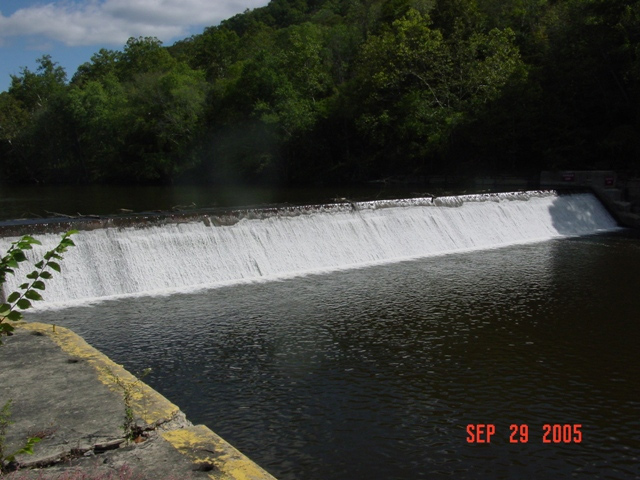
"Lock and Dam 14 were built from 1911-1917 and supports a pool of water that backs up into the forks. The original lock and dam were concrete structures. The structures are located two hundred and forty nine miles above the mouth of the Ohio River."
"1999 Sheet piling backfilled with gravel was placed across the main dam and capped with concrete, abutments were rebuilt with new release valves, derrick stone was placed below the dam, concrete cutoff wall was built in the lock chamber, lock filling valves were sealed"

Berea

The 
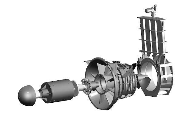
hydropower plant that Berea put in L&D #12 was considered a success, so they are installing one in L&D #14. It should be producing electricity by May 2024. However, this one is a completely different design with a different vendor (Voith), and it will generate 30% more power. The design uses a horizontal axis instead of a vertical axis. Not only does that reduce the amount of concrete that is needed ("reduces by 60%" compared to Lock #12), it allows the use of a submersible trash rack. It also has a movable spillway that can be lowered to allow the river to flush debris downstream. "The powerhouse will contain six Voith StreamDiver submersible turbine-generator units, consisting of four 14.9 StreamDiver axial flow 1490-millimeter propeller turbines directly coupled to a 645-kilowatt permanent magnet generator and two 8.95 StreamDiver axial flow 895-millimeter propeller turbines directly coupled to a 225-kilowatt permanent magnet generator. The total output of the plant will be 3,030 kilowatts." [Berea] I think the permanent magnets means this powerhouse can help restart the grid if there is a regional blackout.

Voith
It uses water to lubricate the bearings and cool the generator. Water lubrication eliminates the issue of oil polluting the river. (The bearings have a service interval of over 10 years. [issuu])
The are 7 standard sizes ranging from a head of 2-12m (6.5-40') and an output of 50-2,000kw.
(Someplace I saw the claim that the turbine was fish friendly. But I can't find that reference.)
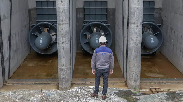
Voith
Note that the concrete work is just flat surfaces.
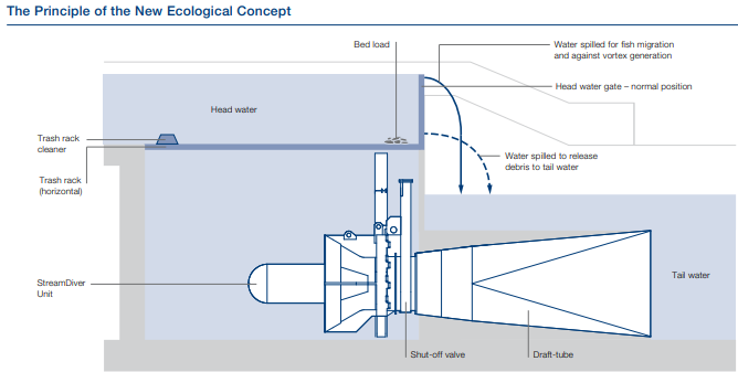
This diagram taught me how the horizontal trash rack works. Trash was definitely a problem with the #12 hydro plant.
Voith-pdf, p3
In addition to run-of-river applications, it can be used in canals for irrigation and cooling and in closed pipes.

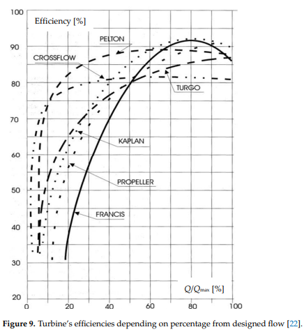
The StreamDriver was included in this study of turbine choices. I did not read the article, but I want to note this reference for future study. The two graphs are from that study. (Banki is crossflow, which is new to me. And the difference between Kaplan and Propeller is another topic I need to research.)
Via ResearchGate
1
[It is interesting that Kaplan can achieve the same high efficiency as Francis, but is more efficient at lower flows.]

2


Monday, January 30, 2023

1910-1998 Kentucky River Lock & Dam #12 and 2.64mw Hydro near Ravenna, KY

(Satellite, 52 photos)

This was part of the Kentucky River Waterway.

The dates of operation come from AbandonedOnline.

While studying the truss bridge at Irvine, KY, I noticed on a satellite map that there was construction activity at this lock. They were building the Matilda Hamilton Fee Hydroelectric Station.

 finance.ky.gov
"Lock and Dam 12 were built from 1907-1910 and support a nineteen mile long pool of water. The original lock and dam were concrete structures. The structures are located two hundred and twenty one miles above the mouth of the Ohio River. A water release valve was installed in 1998 to transfer water downstream in times of drought."
"1997-1998 Sheet piling backfilled with gravel was placed across the main dam and capped with concrete, abutments were rebuilt with new release valves, derrick stone was placed below the dam, concrete cutoff wall was built in the lock chamber, lock filling valves were sealed."

Berea
"In Estill County, along a stretch of the Kentucky River, five turbine generators are converting a million gallons of water per minute into clean electricity. The 13-foot tall, 23,000-pound turbine generators represent just some of the marvelous technology being used at the Matilda Hamilton Fee Hydroelectric Station, the first hydro plant to be completed by an American college or university.  It is also the first small hydroelectric plant built in Kentucky in 94 years. Using the abandoned navigational lock would lower this cost by a third."
The project cost $11m, but they were able to get some federal and Kentucky tax credits to offset that cost.

Berea
"AHA enlisted the hydropower engineers at Kleinschmidt Group to design a powerhouse that could be “shoe-horned” into the lock. They would be able to do that with fully submersible turbine generators developed by Xylem, a leading water technology company based in Sweden. These turbines had significant advantages over conventional turbines. Because they were submersible, they were unaffected by flooding, and they were designed to last 50 years, twice as long as those used for wind or solar plants. Each turbine generator is capable of producing 528 kilowatts of power, for a total plant output of 2.64 megawatts. In addition, variable speed drives not only increased turbine efficiency, they allowed the plant to sync easily to a power grid with existing distribution lines, a significant cost saving."
The turbines are designed to last 50 years, which is twice the design life of wind and solar plants. It provides about half of Berea College's electrical needs. Every source I read claims it will keep 11,000 tons of CO2 out of the atmosphere. But no one mentioned a time frame. Is that over the 50 year designed lifetime for the project? (No. That is an annual savings. [HydroReview])

“The big thing we’re doing here is we’re using variable frequency drives,” Fairchild said, “which basically allows us to let the turbines run at whatever speed they want to run, rather than being fixed by the grid to run at a specific speed.” [Berea]
I'm guessing that the "variable frequency drives" rectify the output of the generators to DC and then invert it to 60hz AC. They said the technology was borrowed from the wind industry. But every wind turbine I've seen turns at the same slow speed.

We can see the holes into which the turbine units will be installed.
Jeremiah Potter, Jun 2020, cropped

It went online in May, 2021. The variable speed technology allows them to get 10% to 15% more power.
2:55 video @ 1:02
 
KentuckyToday, Berea College photo

Removing debris is obviously an operational cost of hydropower plants. The design for their second plant, which is at L&D #14, allows them to easily flush the debris downstream.
2:55 video @ 2:46

I hope the price of scrap steel was high when they removed the downstream gates.
Jeremiah Potter, Jun 2020