Showing posts with label rrPenn. Show all posts

Wednesday, September 3, 2025

1903+2025 W&LE/N&W/P&WV/Wabash Overpass over OH-7 and Coen Tunnel

Overpass: (Satellite)
Coen Tunnel: (Satellite)

P&WV = Pittsburgh & West Virginia

Street View, Oct 2023

W&LE posted a video of the replacement of the spans for this bridge. Here are three screenshots from that video. They made a big deal about laying new track each day so that trains could run during the night. But since there were two independent tracks, I don't see why they just couldn't run on the other side.
Reshard Boyer shared
Mark Adamcik: It is good that the W&LE has rebuilt the bridge with both tracks intact
1
This is one of the views that taught me about Coen Tunnel, which is just west of this overpass.

2
The center of this view shows the old span being trucked away. 

3
In the distance, we see the bridge over the Ohio River.

The video opens with a westbound train on that bridge.
4

Coen Tunnel:
Tom Fitzgerald 0:40 video

The W&LE had a couple more short tunnels west of here (Adams and Fellows), but the Pennsy had a longer tunnel (unnamed, near the top-left corner).
1958/59 Steubenville West and 1968/78 Steubenville East Quads @ 24,000

Sep 2025 Update: the new bridge is done.
This shows the placement of the last new span.
Facebook Reel

Thursday, July 24, 2025

1965 Vandalia Lake Dam on Bear Creek and CSX/Pennsy Bridge over Kaskaskia River near Vandalia, IL

Dam: (Satellite)
Bridge: (Archived Bridge Hunter; Bridge Hunter; no Historic Bridges; Satellite)

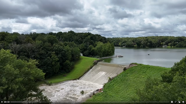
The dam is 1600' (488m) long and 50' (15m) high. Its maximum storage is 13,460 acre-feet. The spillway has a width of 112' (34m). Even though it provides a water source for the region, recreation is considered its primary purpose. [snoflo]

Tyler Schmitt, Realtor, RE/MAX Alliance posted 3:00 video
Here is some footage of Vandalia Lake and the Kaskaskia River after all this rain we had last night (7-20/21-2025). Not something you see every year!
Bryan Grubaugh: We used to take inner tubes over that damn.
Ronda-Ian Brown: Did that flood the road by the spillway....
Bj Tedrick: Ronda-Ian Brown definitely
David Cantrell shared with the comment: "Flooding video around Vandalia from Tyler Schmitt. It has a railroad bridge and tracks visible in part of the footage (around 1:40). I'm unsure of which railroad is shown."
Paul Brewer: Bridge is CSX - St. Louis Line. Nice video!

Bear Creek empties into the Kaskaskia River northeast of Vandalia so that river is also running high.
The road bridge in the foreground is US-51.
Same video

This is one of the lower river levels that I found.
Street View, Dec 2022

CSX has done some work over the last decade to improve the piers.
Street View, Oct 2013

Uploaded by Melissa Brand-Welch via BridgeHunter

Precision fishing guide services posted 0:30 video
The dam at vandalia lake

I presume this is the road by the spillway. Google Maps does not have a street view of that road. This video was posted Jan 11, 2020. Five years ago.
Same video

Thursday, May 8, 2025

NS/Pennsy Railroad Bridge over Allegheny River at Freeport, PA

(no Bridge Hunter; Historic Bridges; Satellite)

Anthony, Jun 2018, taken from the Trail/Pennsy Bridge over Kiskimenitas River

Historic Bridges
1,104' (337m) long with a 440' (134m) main span

Justin Falk, Apr 2021

The bridge is in the upper-left corner of this photo.
USACE Pittsburgh District posted via Dennis DeBruler

1953/55 Freeport Quad @ 24,000

Thursday, April 17, 2025

1913 Amtrak/Pennsy Bridge over Gunpowder River at Chase, MD

(Archive Bridge Hunter; Bridge Hunter; no Historic Bridges; HAERSatellite)

Pennsy's Northeast Corridor had some long bridges. I already knew about the Havre de Grace Bridge over the Susquehanna River. The Gunpowder River has an even bigger mouth at the Chesapeake Bay. Like the Havre de Grace Bridge, plans are being made to replace this bridge.
 
This 4,853' (1.5km, 0.9 mile) long bridge was designed by Gustave Lindenthal and built by Strauss Bascule Bridge using concrete girder spans. [ArchivedBridgeHunter]
Concrete girders must have been a bleeding edge design in the 1910s.
HAER MD,4-BALT,147-
Gunpowder River Bridge. Harewood, Baltimore Co., MD. Sec. 1201, MP 78.86. - Northeast Railroad Corridor, Amtrak route between District of Columbia/Maryland state line & Maryland/Delaware state line, Baltimore, Baltimore (Independent City), MD Photos from Survey HAER MD-45

HAER MD,4-BALT,147-
Gunpowder River Bridge. Harewood, Baltimore Co., MD. Sec. 1201, MP 78.86.

The draw span has been removed so the vertical and horizontal clearances are now 12' (3.7m) and 15' (4.6m), respectively. [WaterwayGuide]
HAER MD,4-BALT,147-
Gunpowder River Bridge drawspan. Harewood, Baltimore Co., MD. Sec. 1201, MP 78.86.

Doug Lilly posted
Future Disaster Scene 
A southbound Amtrak train lead by AEM7 936 crosses the Gunpowder River at Chase, Maryland on April 26, 1986. In just over eight months, this quiet location would become nationally known thanks to a pothead named Ricky Gates.
Doug Lilly shared

Wikipedia
"On January 4, 1987, two trains collided on Amtrak's Northeast Corridor main line near Chase, Maryland, United States, at Gunpow Interlocking. Amtrak train 94, the Colonial, (now part of the Northeast Regional) traveling north from Washington, D.C., to Boston, crashed at over 100 miles per hour (160 km/h) into a set of Conrail locomotives running light (without freight cars) which had fouled the mainline. Fourteen passengers on the Amtrak train died, as well as the Amtrak engineer and lounge car attendant. 
The Conrail locomotive crew failed to stop at the signals before Gunpow Interlocking, and it was determined that the accident would have been avoided had they done so. Additionally, they tested positive for cannabis. The engineer served four years in a Maryland prison for his role in the crash. [report]"

AmtrakNewEra
The replacement bridge will increase the speed limit from 125mph to 145mph or higher.


Monday, April 14, 2025

1940 Delmarva Central/NS/Pennsy Bridge over Pocomoke Riverat Pocomoke City, MD and Cassatt Tower

(Archived Bridge Hunter; Bridge Hunter; no Historic Bridges; Satellite)

Street View, Jun 2023

A tree is hiding the open swing span.
Street View, Jun 2023

Al Tillotson posted four photos with the comment:
Still standing - former PRR CASSATT tower overlooks the Pocomoke River movable bridge in Pocomoke City MD, trackage now operated by Delmarva Central RR.
Views from Tuesday afternoon April 1, 2025.  Train is DCR’s SE-2 returning north to Seaford DE.
1

2

3

4

2018 photo by Timothy and Joann Phillips via BridgeHunter

Wednesday, April 2, 2025

1892,1972,2007 CSX/Pennsy/Philadelphia, Baltimore & Washington over Anacostia River in Washington, DC and Control Tower

Bridge: (BridgeHunter; no Historic Bridges; Satellite)
Tower: (Satellite?)

Boat View, Sep 2014


Boat View, Sep 2014

W Brown, Mar 2017

Tim Evanson via BridgeHunter

Darren Reynolds posted
Conrails ( Ex-PRR) 
"Anacostia" tower 
Washington DC 
This tower is at the Junction of the CSX Capital Sub. 
It's still there as a bridge tenders Office for the Local Lift bridge ( Mostly in the summer)
Photo by: Brad Taylor  2002
Tim Shanahan shared

Richard Maguire commented on Darren's post
Here is a photo of the tower I shot from the train, during one of my many trips from Potomac Yard. This was during the Chessie System era and prior to CSX. I am not sure of the exact date.

The fence messed up the autofocus, but there appears to be a second story roof on the right side of this view. That is the location I selected for the satellite link at the top. However, that location is on the north side of the tracks. However, the bridge and yard tracks in Richard's photo implies the tower was on the south side of the tracks. But the only thing I saw there was the Benning Yard Office, which clearly looks different.
Bike View, Jun 2023

Thursday, December 5, 2024

1917 Pennsy and Reading SOC Bridges over Darby Creek at Essington, PA

(Archived Bridge Hunter; Historic Bridges; B&TSatellite)


Street View, Oct 2018

"Significance: "Because Pennsylvania has few low-lying areas, the Darby River Bridge is one of a limited number of movable railroad structures in the state, and even more rare as an overhead-counterweight bascule bridge." [HAER_data]

HAER PA,23-EDDY,1--1
1. View looking south-southeast by 160 degrees, toward Delaware River. Philadelphia & Reading Railroad Bridge in foreground, Pennsylvania Railroad Bridge behind. - Philadelphia, Baltimore & Washington Railroad, Darby River Bridge, Spanning Darby Creek, South of Essington Avenue (State Route 291), Eddystone, Delaware County, PA

HAER PA,23-EDDY,1--2
2. View looking due east along Pennsylvania railroad, with bascule spans raised.

HAER PA,23-EDDY,1--3
3. View looking due east along Pennsylvania Railroad, showing underside of bascule leaf. Note that reduction gears and pinion operate rack mounted to bottom of girders.

Digitally Zoomed

HAER PA,23-EDDY,1--4
4. Perspective view, looking north-northwest at Philadelphia & Reading Railroad Bridge.

HAER PA,23-EDDY,1--5
5. Perspective view showing counterweights of both bridges and operator's house for Pennsylvania Railroad Bridge, looking southwest by 230 degrees. 

HAER PA,23-EDDY,1--6
6. Detail view, looking north-northwest, showing underside of counterweight and main trunnion bearing for bascule leaf of Philadelphia & Reading Railroad Bridge.

HAER PA,23-EDDY,1--7
7. Elevation view, looking south-southwest, showing bascule leaf, counterweight, and operator's house for Pennsylvania Railroad Bridge. 


Jonathan Konopka posted on Aug 28, 2022
These are the Darby Creek Railroad Bridges in Greater Philadelphia, PA.  They are a pair of bascule bridges that were built in 1917 and carry former PRR railroad lines over Darby Creek.  Photo is courtesy of HistoricBridges.org.
[Actually, the northern bridge carried the Reading Railroad.]

I got another Historic Bridges photo since Elaine Deutsch caught the Pennsy bridge in the closed position on Nov 3, 2014. Since there is more boat traffic than train traffic here, most photos catch the Pennsy bridge in the open position. Conrail abandoned the Reading route east of Eddystone, so that bridge is always up.
Photo via HistoricBridges (link at the top of the page)

Pennsy was north of Reading at Ridley Creek, but south of Reading at Darby Creek. 
1953/55 Bridgeport Quad @ 24,000

8th of 26 photos in B&T (link at the top of the page)

B&T (link at the top of the page), this webpage has a nice history as well as 26 overview photos.

Since the Reading bridge was abandoned soon after Conrail was formed in 1976, it still has its original interlocking machine and signaling pipelines. (The Pennsy bridge was converted to remote control in 2005.) The position-light blog has a lot of photos of the details of the Reading signaling equipment including these three photos.
a
The interlocking frame.

b
The guts of the interlocking frame.

c
Signalling pipelines controlling the rail locks.

Abandoned posted five photos with the comment:
The Darby Creek Bridges consist of two bascule spans crossing Darby Creek near Chester, Pennsylvania. Built in 1917, one bridge carried the Philadelphia & Reading Railroad (later the Reading Company) on its Philadelphia & Chester Branch, while the other served the Pennsylvania Railroad's Chester & Philadelphia Branch.
Today, one bridge remains in use by CSX Transportation and Norfolk Southern Railway. The other was abandoned in 1976 following the formation of Conrail.
1

2

3

4

5

Joe Brown posted five photos with the comment:
Known by the locals as fat Man's bridge 
In the 90s people used to jump off of it 
I think more recently people are just soft.lol or smart .
Delaware County Pennsylvania
1

2

3

A nice view of the closer overhead weight.
4

5