Sunday, January 31, 2021

1915,1936,1950s,1970,1975 Black Warrior (also Bankhead) Lock and Dam #17

(HAERSatellite) Also called the John Hollis Bankhead Lock and Dam

I labeled this wwTennTom because it shares the Tombegbee River part of the Tennessee-Tombigbee Waterway.

 HAER ALA,63-KELMA.V,1--4

JOHN HOLLIS BANKHEAD LOCK & DAM IN TUSCALOOSA COUNTY, BIG INDIAN CREEK PUBLIC USE AREA IN FOREGROUND.


"The original 1915 dam (the only one of the original 17) remains, though not easily accessible to the general public. The current dam is 1,400 feet wide, 77 feet high with a lift of 69 feet." [HAER-data]

The structural height is 111', and the hydraulic height is 103'. The spillway width is 1023' and it can pass 666,000 cfs. [The height and flow rate numbers seem too high.] It has a high hazard potential. [I hope that "high" rating was before the rebuild that started in the 1960s. Wikipedia implies the dam was replaced in addition to building the new lock.] It specifies 2 locks with a size of 285' x 52'.  [BankHeadLake] But judging from the satellite image, the 1915 lock next to the dam would be the 285' x 52' lock. The new lock that was under construction between 1963 and 1980 looks like a more standard 600' x 110'. "The 1963 turbine was replaced in 1997, but stopped working in 2015. In February 2019 Alabama Power invested $17 million to install a new American Hydro turbine, along with constructing a new control room and replacing headgates, stop-logs, wicket gates and other infrastructure." [bamwiki] AlabamaNewsCenter has four file photos of the spillway. A couple of those photos show that it uses sluice gates. The article describes the $17m modernization job, but I still can't find a MW figure for any of the turbines.

Photo from picryl, cropped
Alabama Power Co. built the powerhouse in 1963. The new lock was started in 1966, opened in 1975 and was completed in 1980. (bhamwiki provides a date of 1963 instead of 1966.)

HAER ALA,63-KELMA.V,1--3

JOHN HOLLIS BANKHEAD LOCK & DAM IN TUSCALOOSA COUNTY. - John Hollis Bankhead Lock & Dam, On Warrior River below Port Birmingham, Kellerman, Tuscaloosa County, AL


The following two photos were in the record for the Holt Dam instead of this dam.
HAER ALA,63-HOLT,3-

HAER ALA,63-HOLT,3-

Craig Dodson posted
Lock 17 the uppermost dam on the black warrior
Don Traut: How much traffic up that far these days?
Craig Dodson: Don Traut not much. Shoal creek mine closed last year. From here down does have some traffic.
By U.S. Army Corps of Engineers - Office of the District Engineer, Mobile, District
https://www.sam.usace.army.mil/Portals/46/docs/recreation/bwt/maps/850101-A-CE999-030.jpg, Public Domain, https://commons.wikimedia.org/w/index.php?curid=75694080

Don Traut: Craig Dodson declining coal traffic is going to be hard to replace on many of our rivers.
 
BlackWarriorRiver, Photo by Nelson Brooke, Flight by SouthWings.org
"A series of fourteen locks and dams were built on the river in the late 1800s. In the 1930s, work began to replace those dams with a more modern series of four locks and dams. The river is heavily used by barges for the transport of commercial commodities such as coal, coke, steel, wood, and chemicals. These dams have created a number of lake-like reservoirs stealing the river’s free-flowing beauty."

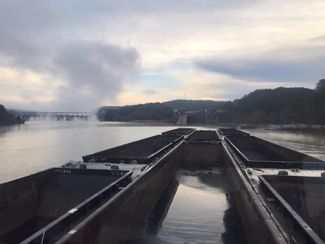
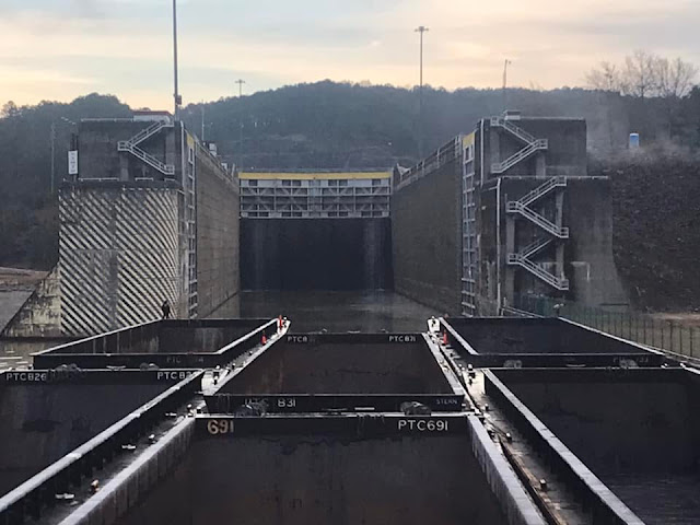
G Warren Simmons III posted two photos with the comment: "M/V Alice Parker making Bankhead Lock on the Black Warrior River."
Jim Colby
Great photos Warren! You may want to join my group and post this. I know that our group members would enjoy seeing your perspective.
1

2


5 construction photos


Saturday, January 30, 2021

1943 US-20 Julien Dubuque Bridge over Mississippi River at Dubuque, IA

(Bridge Hunter; Historic Bridges, has several construction photos; John A. Weeks III; 3D Satellite)

This bridge replaced the 1887 Wagon Bridge.

John Weeks

"Its longest span is 845 feet, total length 5,760 feet and width 28 feet. The clearance below the bridge is 64 feet. When built, the 845-foot main span was the second longest over the Mississippi River, fourth longest in the United States and eighth longest in the world." This bridge is congested and Iowa DOT is working on building another 2-lane bridge just south of this bridge. [Historic Bridges]

Street View

One of several IDOT construction photos on EncylopediaDubuque
Quick Facts: When opened on August 30, 1943 the 845-foot span was the:
             1) second-longest over the MISSISSIPPI RIVER,   
             2) fourth-longest in the United States,
             3) eighth-longest in the world.
 
Ralph Hutches, Dec 2019

LC-DIG-highsm- 39829
Credit line: Photographs in the Carol M. Highsmith Archive, Library of Congress, Prints and Photographs Division.
Carol M. Highsmith's photographs are in the public domain.

Curt Smith posted
I think this is a early 70s slide before the flood wall was bulit at Dubuque alot of things gone now.The tanks in the photos gone.Interstate Power torn down a few years back.Put a few Acbl coal barges into that place.Fischer cold storage gone hotel and waterpark and casino in its place.Two of the boats gone the Arthur J Dyer I think burnt up in a fire many many years ago?Coal Queen gone Dick Bissell owned her in this photo.Then Capt Eldon Newt had her.Artco had her in later years.They scrapped her in Cassville years back.She was a Dubuque Boat Bolier works bulit boat along with Mary thats near Ice harbor entrance.Mary is only survior shes had diffrent names over the years.Shes siting in back of the ex Steamer Alexander Mackenise at Joliet as a few months back future unknown.Yellow tint is from my house fire heat got into the case some slides I couldnt save and had to throw away they were good ones to.

Jayson Young posted
Dubuque on the Mississippi
[The foreground is the gate in the flood wall to provide access to the harbor, which includes the 1930s William M. Black steamboat with tours. ]

Andrey Novikov posted two photos with the comment: "The Julien Dubuque Bridge is a continuous steel-arch truss bridge with a suspended deck that traverses the Mississippi River. The bridge connects Dubuque, Iowa and East Dubuque, Illinois.   June 18, 2023."
1

2


Friday, January 29, 2021

Harvesting Ice and Iceboxes


John Rentschler posted two photos with the comment: "Ice Harvest on the Mississippi  .. Clinton Iowa  See the blocks of ice going up in the Ice House?"
Ed Schloz: And used sawdust to insulate the blocks for the next summer use!!!!
John Rentschler: The walls were insulated with 6-8 inch blocks of cork.
Tom Lindsay: When I was young there were lots of ice houses around still filled with saw dust.
1

2

Raymond Storey posted
 
safe_image

Michael Siola posted

Michael Siola posted
Lori Lucas-Martinez: What purpose is cutting the ice for...

Marlon Harvey commented on Lori's comment

Terry Wisel Heintz posted
Pleasant Lake.

Craig Jon Berndt posted
Pleasant Lake Ice Co., undated. Phone number 176. The blanket on the horse reads DEKALB xxxxx CO. HARDWARE.
Gail Barnard: Does this go back to the big old ice houses on the east side of the railroad tracks [NYC]? My dad (Byron Gramling 1912-1981) once drew for my son a schematic of the process with the cutting on the west end of the lake and conveyors up and over the road to where ice was stored in the big ice houses for use by the railroads in their passenger cars. I believe he said there was a kind of grass (he referred to it as swamp grass, but it likely had a scientific moniker) used to insulate around and between the big blocks. Quite a process in those days. One can only assume there were local outlets for the same product. Fascinating bit of history for a sleeping looking little town whose footprint went miles beyond. Gail Gramling Barnard.
[I suspect that NYC was more concerned about icing the refers than their passenger cars.]
Lori Smith DeMille: Last year, a couple of days before my father passed away, he had a day of clarity. He could not have any cold water, and he started talking about the ice house at Pleasant Lake as if he were still there in the moment. I didn’t know if there was such a place or not. Thank you for sharing this.

1:00 video @ 0:05

The icehouse in Newburgh, IN, has been preserved.
DeBruler-icehouse

DeBruler-icehouse

ReconnectWithNature
Forest Preserve District of Will County posted
Lake Renwick is now a place known for the birds, but back in the day it was an ice harvesting hot spot.

safe_image for THE BIG CHILL

another safe_image for THE BIG CHILL
Forest Preserve District of Will County posted again
Throwback Thursday: As we brace for some very cold temperatures, a look back at how activity around some current forest preserves used to heat up when the mercury dropped.
Eileen Broderick Postregna: Do you know what the year is?
Forest Preserve District of Will County
: We do not know the year the photo was taken but we do know that an icehouse was built at the site in 1914 and large blocks of ice were stored there until they were shipped to Chicago. Ice harvesting continued until 1924 when the icehouse was destroyed by fire.

I learned from this video that the ice was stored in the smaller top compartment. I assume the bottom compartment is the colder food and the tall compartment is a little warmer. Of course, refrigeration made iceboxes obsolete.
Urban Remains, cropped

DeBruler-refrigeration


Thursday, January 28, 2021

1909-1970s N&W/Virginia Bridge over New River in Glen Lyn, VA

(Bridge Hunter; Satellite)

Technically, the label should not be rrNaW because this route was still the Virginia Railway in 1928. But rrNaW is much more informative than rrMisc. The N&W mainline used to go under the bridge and it is still intact.

The deck is 120' (37m) high and the bridge is 2,155' (657m) long. [TheTracksidePhotographer]

Doug Bess posted
This is my photo of the former Virginian Railway bridge over New River and the former Norfolk & Western at Glen Lyn, VA taken in the spring of 1968. Approximately four years later the bridge was removed due to the US 460 widening project. Only the concrete piers in the river remain today.
Jason Downard: Doug Bess do you have any pictures of the line between Glen Lyn and Kellysville before 460 was built?
Doug Bess: Jason Downard there is one on my blog. The link is https://wvrails.net/?p=1130 Also there is a photo of the VGN powerhouse at Narrows.
"The VGN was in existence for a short 50 years. The many impressive bridges and tunnels (mostly in West Virginia) enabled the VGN to provide a superior gradient for hauling coal especially over that of N&W’s parallel route between Kelleysville, WV (east of Bluefield,WV) to Roanoke, VA and on to Norfolk....The electrified portion of the railroad between Mullens and Roanoke was dismantled in the last half of 1962."
Jason Downard: Doug Bess what I was really wanting to know is if there was a tunnel between Glen Lyn and Kellysville where 460 is now... Hales Gap Tunnel?
Doug Bess: Jason Downard yes there was. I wish I had taken a picture of it. It was right behind me in the photo of the coal train.

Jason Downard commented on Doug's post
Ted Gregory posted
Giant Virginian Railway Electrics over
massive New River/ Glen Lyn (WV[VA]) Trestle.
Correction: This bridge was demolished in 1972
VGN EL2-B 126 wb
June 12 1956
R J Cook
Ted Gregory shared

Jason Downard commented on Doug's post
Collection of Tracy Walker, License: Creative Commons Attribution-Share-Alike (CC BY-SA)
 
Ed Painter posted four photos with the comment:
Glen Lyn, Virginia (on the West Virginia border) where we moved when I was 4 (1955) and lived until moving to Narrows, VA following my 4th grade year.  We lived in a Company house (a Sears Roebuck house) on the hill behind the plant.  The town was centered around Appalachian Power Co.'s Glen Lyn coal fired power plant where my Dad worked in management.   The plant had 6 units having been built in 1918 (4), 1944 (1), and 1957 (1).  The plant was shut down in 2014.  Glen Lyn was a grand place to live for a little boy that loved trains.  The town was literally surrounded by the N&W and Virginian Ry mainlines  (N&W steam that transitioned to diesel and the Electrified locomotives of the Virginian) and you couldn't leave town without crossing either one or both of them.  The mainlines were also very close to our house and right of ways made great areas play on and watch trains from .  Both mainlines served the plant.  The area was also truly beautiful.  At Glen Lyn the East River flows into the New River.  At Glen Lyn the New River Valley is surrounded by significantly high mountains deep within the Appalachians.  I enjoyed my time living there!
Randall Hampton shared with the comment: "Former crossing of N&W and Virginian."
1

2

3

4

Ted Gregory posted
A rare pre-electrification era shot of the Virginian Glen Lyn bridge from the N&W HS. This train meet will never be repeated. This masterpiece of a bridge was demo'd, along with several miles of VGN mainline as part of a project to make even more room for US 460 thru the Narrows in VA around 1972. That is a Virginian Rwy passenger train soaring over the New River and an N&W train. Note the cool raw material loads in the gons in the foreground.
Doug Bess: The former Virginian right of way was utilized either side of the New River bridge and sister bridge over East River for the US 460 widening. The bridges became isolated which is why they they were removed. Also Hales Gap Tunnel was filled in.
Rob Nichols: From the Google overheads it looks as if the westbound lanes of US 460 east of the former bridge must have been built on the original VGN right of way for several miles. It's a safe bet that at least half the ton miles hauled through that gap today use the highway, with the NS line getting the remainder.
Doug Bess: Rob Nichols it is the eastbound lanes of US 460 that were built on the former Virginian right of way as far as Narrows

eBook via Bridge Hunter

safe_image for Demise of the New River Bridge
[This includes a nice history of the VGN route.
The piers are 90' above water level and the rails are at 120'. The bridge is 2,155' long.]

The piers are still standing.
Satellite

Doug Bess commented on a post
Here is another view of the New River Bridge I took in 1968 looking eastbound. It was quite an impressive structure. I got word that the US 460 widening project would result in the removal of the bridge so I went with a railfan friend at the time to Glen Lyn, VA from the Charleston, WV area to photograph it.

Doug Bess commented on a post
not a good shot but here is a coal train going across the bridge at Glen Lyn, VA in 1968.
Ted Gregory: Wow that's awesome. 6 units!

Ted Gregory posted
What a sad difference 50 years makes.
Glen Lyn, VA
Ted Gregory posted
Then and now.
The massive Virginian Railway New River Trestle in Glen Lyn, VA.
The top pic is from the Collection of Tracy Walker. (way b4 my time)
The lower pic of the remnant piers is my pic from 7-27-2021.

Ted sent me his original photo

safe_image for Demise of the New river Bridge