Showing posts with label water. Show all posts

Saturday, July 12, 2025

Los Angeles, CA: New 18' Outfall (Effluent) Tunnel Collapsed, All 31 Workers Escaped Unharmed

(Satellite)

lacsd, p1

The yellow cylinder to the left of the opening is the basket that the crane used to bring up eight workers at a time. The workers had to climb over a 12-15' pile of loose soil leaving just 3' at the top of the tunnel. Only minor injuries were reported among the 27 workers and 4 rescuers.
ABCnews

ABCnews @ 1:14

The old tunnels were built in 1937 and 1958. The tunnels dump treated wastewater into the ocean. [lacsd, p2] If I remember correctly, they were 8' and 12' in diameter. The new tunnel is 18'.
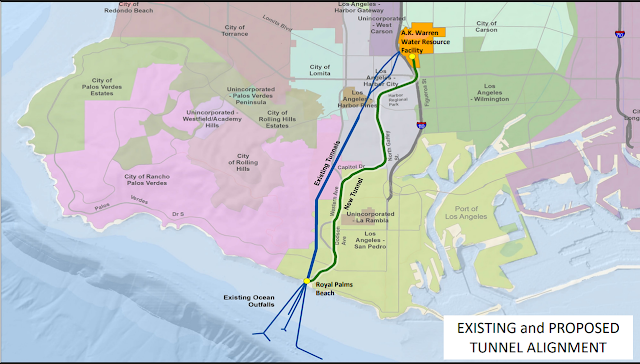
lacsd, p3

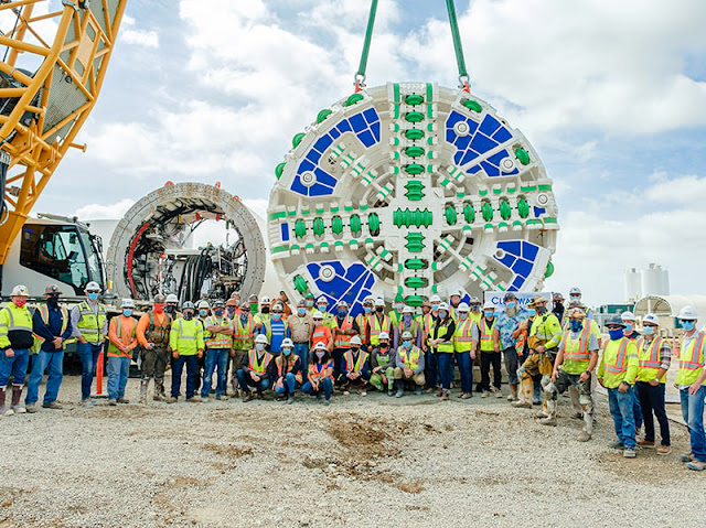
In this view, we can see in the lower-left corner a stockpile of the segments that the Tunnel Boring Machine (TBM) uses to line the tunnel. This news report said the workers had to walk 5 miles to the entrance. Other reports indicated that they had to walk about a mile to get to the shuttle that would take them the last 5 miles to the entrance. The tunnel's planned length is 7 miles.
ABCnews
"There was a location that squeezed the tunnel and forced it to partially collapse." [Robert Ferrante, Chief Engineer & General Manager, LA County Sanitation Districts @ 0:45]

Satellite

"The cave-in apparently happened between the tunnel boring machine, 5 miles in from the only entrance, and the construction crew working 6 miles in, said Michael Chee, spokesperson for the Los Angeles County Sanitation Districts, which is in charge of the nearly $700 million project. The workers were about 400 feet underground....Firefighters said workers had to climb over 12 to 15 feet of fallen dirt and debris to reach the tunnel boring machine and then were transported by vehicle back to the opening. Some people had to be pulled out....The workers were operating the boring machine when the collapse occurred said Robert Ferrante, chief engineer and general manager for the sanitation districts. 'A section that they have already built had squeezing ground and had a collapse, a partial collapse,' he told reporters." [Associated Press article by Damian Dovarganes and Julie Watson in the July 11, 2025, edition of Chicago Tribune]
The first sentence confused me when I read it because a TBM works at the end of the tunnel. Given Robert's comment, I think the TBM was six miles in, and the collapse happened around the 5-mile mark. It is scary to learn that the soil pressure could cave in the concrete segments that are installed to hold the ground up. Perhaps grouting hadn't reached its full strength.

lacsd, p5

This diagram makes me appreciate that the Deep Tunnels dug in Chicagoland were through competent rock.
lacsd, p7

The contract for the Clearwater Project was awarded for $630,500,000 in Jan 2019 with a "notice to proceed" in Apr 2019. The main shaft was dug Jan-Jul, 2020. The TBM was delivered in Oct 2020, and mining began in Jan 2022. As of July 24, 2024, 4.4 miles had been dug, and completion was expected to be in 2Q 2025. [lacsd, p4,5] (I'm writing this July 12, 2025, so that schedule has already slipped.)

"Today [I could not find a date on the webpage], the Sanitation Districts of Los Angeles County (Sanitation Districts) awarded a $630 million construction contract for the Clearwater Project to Dragados USA, Inc....Dragados brings extensive tunneling expertise to the Clearwater Project. The firm has completed more than 530 underground projects in 20 countries, totaling over 800 miles of tunnel. For a recent project in Seattle, Washington, Dragados utilized a 57‐foot diameter tunnel boring machine, which was the largest tunneling machine in the world at that time. “We look forward to working on this important infrastructure project,” said Tom Robertson, Vice President of Dragados. “Our vast experience in tunneling through a wide range of geological conditions will be an asset for the Clearwater Project.”" [cwea]
The Seattle tunnel project was a disaster. The TBM got stuck. They had to dig an access shaft, bring the TBM head up for repair, then lower the head back down to the machine. I had started detailed notes on the tunnel project while it was still in progress, but I got so depressed that I quit following the project. I would not be surprised if lawsuits are still in progress. They were very lucky that it got stuck below vacant land rather than under downtown buildings.
Dec 14, 2020: Mammoet posted
#MilestoneMonday: After a year of meticulous planning, #Mammoet liberated the 1,700t tunnel boring machine, "Big Bertha", in just 16 hours after it had stalled approximately 36m (120 ft.) underground in #Seattle.

Sunday, June 29, 2025

Milk River Project (St. Mary Canal) and St. Mary Siphon Blowout

Diversion Dam: (Satellite, this is the headwaters of the canal.
Kennedy Siphon: (Satellite)
St. Mary Siphon: (Satellite)
Halls Coulee Siphon: (Satellite)
Spillway into Milk River: (Satellite)

The St. Mary Canal takes water from the St. Mary River before it enters Canada and moves the water east to dump into the Milk River. This supplies water for towns and agriculture in north-central Montana.
ktvq
This canal is evidently also called Montana's Hi-Line and 18,000 residents depend on it for water in the 200-mile Milk River Irrigation Project.
Congress appropriated money in 1905 to build the system. But, after it was built, Congress changed their mind and quit funding maintenance.

On Jun 17, 2024 the St. Mary Siphon blew out.
ktvq, Credit: Milk River Joint Board of Control

The blowout not only stopped the source of water to the irrigation project, it caused flooding in the St. Mary river.
MontanaFreePress, Credit: Bureau of Reclamation
"The failure involves the St. Mary River Siphon, which is composed of a pair of 90-inch [2.3m] riveted steel barrels that traverse a 3,200-foot [975m] section of the St. Mary Valley to divert water to the North Fork of the Milk River." The failure occurred "while U.S. Bureau of Reclamation personnel were monitoring a crack in the siphon."
The downstream pipes were built in 1915. Five hours after one barrel broke, the other one also broke. And the concrete structures holding the pipes were washed away.

krtv_repair, Credit: MTN News

krtv_repair

same video

krtv_repair, Credit: MTN News

usbr
[I wonder where the second pipe broke.]
"The siphon has a maximum head of 165 feet and was constructed in two phases, with the downstream barrel completed between 1912-15 and the upstream barrel after 1925. The siphon has undergone extensive repairs due to seepage, corrosion, and buckling. A cathodic protection system was installed in the 1950s to address these problems. However, unstable valley sidewalls have caused further movement of the steel barrels and concrete supports, leading to additional damage."

Sun 25, 2025:
krtv_restored
"A $70 million project has successfully restored water flow to the Milk River along Montana's Hi-Line"

The Milk River Project posted 1:05 video
🛠️ One Year Ago Today [Jun 17, 2025]: The St. Mary Siphon Failure 🛠️
June 17 marks one year since the unexpected failure of the St. Mary Siphon—an event that cut off irrigation deliveries, disrupted communities, and triggered an all-hands-on-deck emergency response across Montana’s Hi-Line and beyond.
What followed was nothing short of extraordinary. Contractors, crews, engineers, tribal partners, agencies, and local leaders came together with urgency, grit, and determination.
In less than a year, we’ve secured emergency funding—thanks to the State of Montana, NRCS, and the federal government—redesigned major infrastructure, and made incredible construction progress to restore and strengthen this critical system.
The failure was a stark reminder of how fragile our aging infrastructure really is—and just how essential the St. Mary system is to north central Montana. But it also showed the resilience, collaboration, and resourcefulness of this region when it matters most.
We’re not across the finish line yet—but we’re close. And we didn’t get here alone.
Thank you to everyone who showed up, rolled up their sleeves, and stayed committed every step of the way. The Milk River Project isn’t just infrastructure—it’s a lifeline.
#StMarySiphon #MilkRiverProject
Project Completion: July 2025
Fun Video Editing: Colynn Kerr

A video on the krtv_restored webpage
[I quit watching when they started talking about every agency stepped up.]

same video
[I took this screenshot because of the view of the diversion dam release structure.]

And this is the other end of the canal. This structure had a catastrophic failure on May 17, 2020. They replaced Drop 2 as well as Drop 5. [MilkRiverProject_emergency]
The Milk River Project posted

3:06 video
Water was restored on Oct 10, 2020

The Milk River Project posted
🎥 As Promised — Last Night’s Flyover! 🎥
Just after 10:00 p.m. last night, the St. Mary Siphon outlet finally came to life as water completely filled the pipe and began its journey down the historic St. Mary Canal. This drone footage flies from the outlet structure to the inlet structure of the St. Mary Siphon — a perspective only possible thanks to the skill, dedication, and long hours put in by these amazing crew.
💧 We’re officially flowing — and it’s beautiful.
Quick update: the water is now about 1 miles from the Halls Coulee Siphon inlet and we expect it to arrive at appx 5:30 p.m.
Fun fact: it's currently moving at about 0.43 mph overall — slow and steady wins the race, right?

save video, the inlet structure.

I guess this is also the intake structure.
MontanaFreePress_expected, Credit: Milk river Project

The old inlet structure had no provision for stop logs or control gates. It looks like they learned their lesson and the new inlet structure can stop the flow of water into the pipes.
Satellite

Another view of the inlet structure as the water first approached it.
Facebook Reel

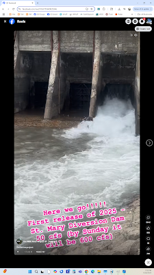
And another view of the diversion dam after they do the first release into the repaired canal.
Facebook Reel

The Milk River Project posted four photos and two videos with the comment:
💧 Halls Coulee Update: Why We’re Starting Early
Let’s talk about Halls Coulee and the difficult—but necessary—decision to stop diversions to the Milk River around August 15th so crews can finally address this aging structure.
Over the off-season, teams worked hard to temporarily stabilize the siphon by installing Hydratite seals in the worst trouble spots. These are holding for now, but this siphon is over 100 years old, and every patch just shifts the problem elsewhere as the pipe expands and contracts.
✅ A bypass channel is now in place, allowing NW Construction and Sletten Construction to begin dirtwork and start building the outlet structure while water continues to flow.
The inlet sits on an extremely steep slope with wide wing walls, and safely setting the new structure alongside the failing one within our right-of-way would require extensive shoring designs that come with serious safety and engineering challenges.
With the diversion running until August 15th, we estimate approximately 37,000 acre-feet of storage by Sept 30 will be in Fresno Reservoir to help meet municipal demands throughout the winter.
We are also working through one final permit for a land use agreement outside of our right-of-way (for parking, staging, road access, material sales, etc.) with the Blackfeet Tribe, and once that’s in place, all permits will be secured.
Starting early not only reduces risk to future water deliveries and worker safety but also helps us avoid heavy winter construction—think heated tents, blankets, and costly delays in extreme cold.
We understand this timeline isn’t ideal for everyone, and it’s not a decision we made lightly. But as a team, we believe moving forward now is the safest and most responsible choice to protect the Milk River Basin’s water supply for decades to come.
[The two videos were of active leaks.]
Matt Bolland: With the old system being above ground, leaks were easy to spot, like these videos. With the new pipes underground, how difficult will it be to detect minor to major leaks before they become catastrophic?
The Milk River Project: Matt Bolland each of the St. Mary and Halls Coulee pipes had sections that were buried. From previous experience, water is incredibly powerful—when there’s an issue, you’ll either see it leaking or notice the vegetation above starting to change.
Jody Mann: How much water does Canada take that is diverted by the St. Mary project? How is this monitored?
The Milk River Project: Jody Mann Right now, Canada will not take any irrigation water from the St. Mary Project—but our water volumes will help their municipalities tremendously. Under the Boundary Waters Treaty of 1909 and subsequent agreements, Canada is entitled to receive up to half of the natural flow of the Milk River, but none of the water diverted through the St. Mary Canal is allocated for Canadian irrigation. There is also deficit accounting but we haven’t run one this year either with the failure. Little complicated.
The volume delivered is measured using USGS gaging stations at the International Boundary, which record and report real-time flows. The International Joint Commission through Accredited Officers oversees compliance and reviews these records to ensure both countries are meeting treaty obligations and accurately accounting for any deliveries.
1

2

3

4

Tcrowe For MT commented on the above post
Got to see the historic Hall’s Coulee siphon last week during the tour.

The Milk River Project has posted weekly updates with lots of nice photos. One update indicated that the diversion dam was also rebuilt during the St. Mary Siphon caused outage.

Here is a May 27, 2025 update.
The Milk River Project posted a 1:19 video
It was an unusually quiet flight over the St. Mary Siphon project this weekend—no crews onsite and no wind (we’ll take the win!). Our hardworking crews got a well-deserved long weekend for the holiday and are now back at it—recharged and ready to keep pushing this project forward. 💪🚜

Facebook Reel

Thomas Ahkaapoii Gervais posted
Water at the Milk River


Saturday, May 31, 2025

1789 Royal Springs Bridge in Georgetown, KY

(Archived Bridge Hunter; Bridge Hunter; no Historic Bridges; Satellite)

2013 photo by James McCray via ArchivedBridgeHunter
Overview (Looking South/North Face of Bridge)

Tammy Collett [Google Maps did not provide a correct link], Aug 2019

George Dawson [Google Maps did not provide a correct link], Oct 2021

Linda Louie posted
Located in downtown Georgetown, this is Kentucky's oldest bridge, constructed in 1789—back when Kentucky was still officially part of Virginia until it gained statehood in June 1792. Built using a dry-stacking technique with no mortar, this historic structure stands as a remarkable example of early engineering.
Pict by : Kentucky travels

This must be the south face.
2013 photo by James McCray via BridgeHunter

The spring just south of the bridge is the water source for the town.
Satellite

Sunday, April 13, 2025

1950s Gross Dam and its Expansion

(Satellite)

Mary Lahmann, Apr 2020

anderson amaya, Sep 2020

Oliver Novi, Oct 2020

R B, Feb 2018

CivilGEO Inc. Software posted, Photo courtesy Denver Water
Judge Halts $531M Gross Dam Expansion in Colorado
A federal judge has ordered a stop to Denver Water’s $531M Gross Dam expansion, citing improper permitting by the U.S. Army Corps of Engineers. With the project 60% complete, the ruling threatens water security for 1.5M people and underscores the growing challenges of building critical infrastructure amid environmental litigation.
Read more: https://www.enr.com/.../59980-judge-halts-construction-on... [the link took me to a different article]

DenverWater
When the dam was designed in the 1950s, it was designed to have additional phases of added capacity. They are now implementing those plans for expansion. "The project will raise the height of the existing dam by 131 feet [40m]. This will almost triple Gross Reservoir’s capacity, from approximately 42,000 acre-feet to 119,000 acre-feet."


Facebook Reel