Showing posts with label rrPennIndustrial. Show all posts

Tuesday, July 2, 2024

Pennsy's Calumet Circle Passenger Service

Back in the horse&buggy days when railroads ran local commuter services.

MWRD posted
Construction of a section of the Calumet Intercepting Sewer looking north from an area near the intersection of 100th Street and Avenue N in Chicago on September 28, 1922. 
Bob Lalich shared
There is an interesting detail in this photo of PRR's Calumet River RR, looking north from 100th St. The line is signaled because PRR had been running passenger trains over the line. The trains ran in a loop over the Ft Wayne line to Clarke Jct, then west over the SLIC/B&OCT to Hammond Jct. From there, the obscure Hammond/Wolf Lake Branch was used to reach the SC&S and Cal River RR in Hegewisch. These trains were accommodations for factory workers. I believe the trains were discontinued in the 1920s but I don't have a date.

Larry Candilas commented on Bob's share
1915 - The Calumet Circle Route!!

Tuesday, January 18, 2022

1901 Irondale Grain Elevator on the Calumet River that was served by Rock Island and Pennsy

(Satellite, not only is the elevator gone, the slip has been filled in)

The main post for this elevator is here.

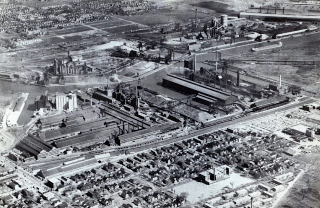
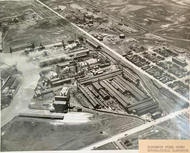
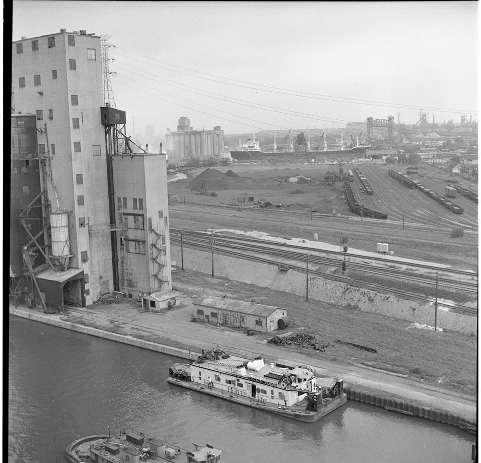
Dennis DeBruler posted four images with the comment:
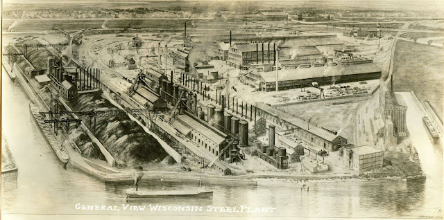
These three photos came for a share concerning Wisconsin Steel in Chicago, which was on the west side of the Calumet River south of 106th Street.
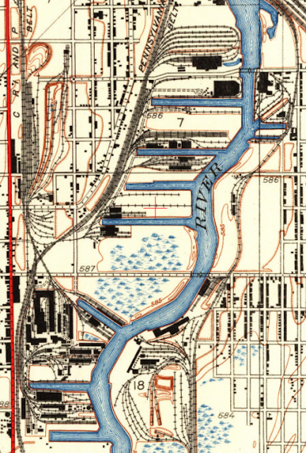
I copied them because they all include a grain elevator along a dedicated slip. (That slip has since been filled in.) I asked the name of the elevator because it does not show up in the 1901 Sanborn Maps. Dale Windhorst answered that it belonged to the Rock Island Railroad. A topo map shows how the Rock Island used to access this elevator.
1929 Calumet Lake Quadrangle @ 1:24,000
Other topo maps indicate that the elevator and the slip disappeared between 1977 and 1991. Sadly, Wisconsin Steel also disappeared between those years.
Bob Summers: Garvey International had a waterfront terminal in Chicago that if memory serves me correctly it was known as the Rock Island Elevator. It was concrete, so likely was built on the same site that this early wooden terminal occupied. That terminal suffered a major grain dust explosion circa 1980 and was razed.
Dennis DeBruler: Bob Summers The second and third photos show a major concrete annex.
Bob Summers: Ok. Finally saw the 1929 date, so that might be the one.
Brett Ellis: Also Norris Grain later Pillsbury
Dennis DeBruler: Bob Lalich provided the following information in a different forum:
"The ownership and operators of grain elevators changed numerous times over the years. This elevator was known as Irondale Elevator. At various times it was either owned or operated by Rosenbaum Grain, Illinois Grain, Chicago Grain, Norris Grain, and Louis Dreyfus, according to documents in my collection. Both PRR and Rock Island served the elevator. The tracks were retired and removed in 1965. Wisconsin Steel Works bought the land in 1966."
1

2

3

4


Sunday, September 5, 2021

Maps of Railroads in Southeast Chicago

I know enough about the railroads in Southeast Chicago to know that it was a spaghetti bowl of tracks. Because there was a lot of industry in the area, one railroad would build tracks along side another railroad just to access a large industry. These maps help untangle the noodles.

Michael Mora posted seven images with the comment:
U.S. government maps of just some of the railways that ran through Southeast Side, 1916-1919: Chicago & Calumet River Railroad; Chicago & Western Indiana Railway; Calumet Western Railway; Chicago Short Line Railway; Elgin, Joliet & Eastern Railway; Indiana Harbor Belt Railroad; Pennsylvania Railroad. Interstate Commerce Commission, U.S. National Archives, catalog.archives.gov

2

3

4

5

6

7

Daniel Bovino posted
Here’s a late 1880’s view of Roseland, Pullman, and the Calumet region. It shows a Lake Calumet in its original state and other lakes that have since been filled in. Hyde Lake is almost completely gone. Wolf Lake and Lake George have also been altered by the industrial push into this region over the last 150 years. Thankfully, some of our remaining area wetlands are under restoration. 
I received this wonderful map from Mendel Alumni, John Ormsby.
John Ormsby: Map taken from Library of Congress. Map Room in Jefferson Building
Paul Jevert shared
1880's topographical map of the southside at that time unincorporated into the City!

Back in 1916-19, the C&WI still owned the BRC tracks. BRC was created for the freight operations so that C&WI could concentrate on passenger service to the Dearborn Station.  

Saturday, August 28, 2021

Rail to Water Transfer Dock on Calumet River

(see below for satellite information)

Mike Delaney posted
W.W. Holloway at rail to water on the Calumet River Chicago.
Robert Haller: Days of old, made many loads up to Valley Power Plant in Milwaukee.
 
Growing up in Chicago posted
1951 - Freight trains and ore thawing at 101st Street and Calumet River railyards.
Terry Spirek: These locomotives are from the Burlington Route , and on loan to the steel mill to help to thaw out the ore in the hoppers . .
Joseph Obrien shared

Marine Historical Society of Detroit posted
The whaleback tanker Meteor tied up at the Rail to Water Transfer Corp. facility in the Calumet River. Unknown date. J.R. Williams photo from the Jim Bartke/MHSD collection.
  • Association for Great Lakes Maritime History 
    Follow
    Launched in 1896, what would become the whaleback freighter Meteor was built in West Superior, Wis. by the American Steel Barge Co. Christened the Frank Rockefeller, the 380-foot vessel (LOA) was designed to carry bulk cargoes and tow one or more unpowered whaleback barges to increase its cargo capacity.
    The American Steel Barge Co. was founded in 1888 by Capt. Alexander McDougall, the inventor of the whaleback design. McDougall’s goal was to create a new type of vessel that could be built using relatively low-skilled workers. In addition, those vessels would be capable of carrying heavy cargoes of iron ore in a wide variety of weather conditions.
    The Rockefeller operated in the iron ore trade on the Great Lakes initially as part of a fleet of whaleback freighters and barges leased and managed by the American Steel Barge Co. of Buffalo, New York. In 1900, the fleet was sold to the Bessemer Steamship Co. which became part of the Pittsburgh Steamship Co., a subsidiary of the U.S. Steel Corp., in 1901.
    During the winter of 1925-26, the ship’s cargo hold was rebuilt and strengthened. One year later, the vessel was sold to the Central Dredging Co. of Chicago which planned to convert it into a self-unloading dredge. However, after only minimal work was done, the whaleback was returned to service as a bulk freighter.
    In 1928, the vessel was renamed the South Park. Early in the Great Depression of the 1930s, it was laid up after Central Dredging ceased operations. In 1934, the ship was sold to Maurice H. Sobel of Detroit, Mich. who sold it in 1936 to the Nicholson Transit Co. Nicholson then sold it to the Erie Steamship Co. later that same year.
    In 1942, the whaleback went aground and was wrecked near Manistique, Mich. After being recovered, the vessel was towed to Manitowoc, Wis. It was then laid up there until 1943 when it was sold to Cleveland Tankers, Inc. The ship was then converted into a petroleum tanker at Manitowoc by the Manitowoc Shipbuilding Co.
    After work was completed, the vessel was renamed the Meteor. On Nov. 21, 1969, the tanker went aground and wrecked near Marquette, Mich. After recovery, it was towed to South Chicago, Ill. for repairs. Once repaired, the ship was towed to Manitowoc, Wis. where it was permanently laid-up.
    In 1972, the Meteor was sold to the City of Superior, Wis. for use as a museum ship and is now on display on Barker’s Island in Superior. The vessel was inducted into the National Maritime Hall of Fame at the American Merchant Marine Museum in Kings Point, New York in 1984.
Marine Historical Society of Detroit shared
The whaleback tanker Meteor tied up at the Rail to Water Transfer Corp. facility in the Calumet River. Unknown date. J.R. Williams photo from the Jim Bartke/MHSD collection.
Mark Janovec: Great photo! I'm so used to seeing her in Superior as a museum that it's nice to see a photo of her when she was still active.
Dennis DeBruler commented on the above share
It is also nice to see what the facility looked like. Today it is just brownland.
https://www.google.com/maps/@41.711555,-87.5469954,664m/data=!3m1!1e3

Lou Gerad posted
Robert C. Norton at Rail to Water in South Chicago, 1974.
Dan Vandenberg: Great picture! In more recent years called KCBX. Now I'm wondering...is KCBX still shipping coal from there? Haven't seen much posted on boats loading there recently.
Comments on Lou's post

That would be part of the Rail to Water on the left and the 100th Street Bridge is in the air.
Mike Delaney posted
The International heading up river on the Calumet. Anybody who has heard the horn on this thing would know which one it was long before you saw it. I know I posted this shot before somewhere but it shows the care and pride these companies took in their vessels no matter how old. Both this and the Harvester were in mint and I mean mint and pristine condition. I wish I could have sailed in that tiny fleet. She was my favorite oldy and it was my pleasure to see her up close. I almost cry when I look at this shot. Boat gone, International Steel plant is gone.
[The steel plant it was headed to was Wisconsin Steel.]
Scott Liberty: Many people don’t know that the red and black IH logo is an abstract representation of a man on a tractor.
[Some comments include a couple more photos of the ship on the Calumet river.]

A facility to transload coal from rail to ships became obsolete when power plants switched from Illinois Basin coal to Power River Basin coal. Then local refineries switched to processing crude oil from Canadian tar sands. The residue product from that oil was petcoke instead of asphalt. So the facility switched to transloading petcoke to ships.

But the dust blown off the piles was a serious pollution hazard, so then it became nothing.
Satellite, accessed Jan 2020

Mike Delaney posted
Calumet River Chicago.  Cliffs Victory on the left and some foreign rusted out crapcan on the right at Rail to Water.  This was during a brief iron miners strike so the Victory was layed up wet.  Lots of opinions on the Calumet, Rouge and Cuyahoga rivers as far as pollution goes.  We kicked up a dead body in this river with the bow thruster on the Grace heading for Interlake Iron farther up the river.  Didn't get to see it myself.  Did the same thing in the Cuyahoga on the Snyder Jr. backing into the turning basin coming from Republic Steel with the prop.  I did get to see that one.  The deceased was wearing a brown suite covered with crabs.  The Coast Guard came and picked up the body put him in a bodybag with his feet sticking out layed him on the rear platform on the outside back of the boat and down the river they went with several pleasure boats following taking pics.  Couple years later on the Ayers I was being lowered to the J&L steel dock on the Cuyahoga river, they lowered me too soon, too fast, and I ended up in the water up to my chest and was between the boat and the dock in between two giant earthmover tires hanging from the dock as the boat came in.  took four guys to pull me back up and out enough to climb onto the tire.  Everybody was heaving the blocks over and bedlam was going on the deck as man overboard was called.  I got back on board wearing about 20lbs of Cuyahoga river.  mate says you OK, I said great time for a swim.  Says go take a shower and wash your clothes your done for the night.  I would rather have swam in the Rouge.
[That is the 100th Street Bridge in the foreground.]

Today conveyor belts have developed well enough that the material is stored in piles. Before that, coal was stored in hopper cars. That is why most of the land back then was used for yard tracks. Then a lot of those tracks were removed to create land for the storage piles. You can see that evolution of hopper to pile storage in the still active coal docks in Newport News, VA.
Bob  Lalich commented on Nick Fry's share
Here is a Life magazine photo of the elevator taken in 1951.
Bob Lalich Dennis DeBruler - the hoppers are coal for Rail To Water.

Dennis DeBruler replied to Bob's comment
This photo shows the many tracks north of the elevator in this 1977 topo was used for storage. Are those iron ore cars? They look rather short.

John W. Barriger III National Railroad Library Flickr
[The south side of the yard and a ship in the background.]

John W. Barriger III National Railroad Library Flickr
[The north part of the yard and the Com Ed 100th St. Generating Station in the background.]

Bob Lalich Flickr, Aug 1984
BRC 100th st Yard
BRC TR4 set switches Rail To Water near 100th St, 8-84.

Jim Prrfan posted
Rail to Water dock on Calumet River 4-1968. Steel Mill related.
Jim PRRFan photo
Dennis DeBruler shared to Southeast Chicago Historical Society
https://www.google.com/maps/@41.7117017,-87.5474876,786m/data=!3m1!1e3
Daniel Kleszynski: RTW was opened in 1948. At one time it was owned by 7 coal mining companies. The docks as seen in the photo were constructed in 1954-1955. The North ship loader (closest on in the picture) was the original stationary ship loader.
Dale Windhorst: I just recently found out that it was built by the Chicago and Western Indiana RR. [The BRC was created from the freight operations of the C&WI. [Dennis DeBruler]]
Jeannie Caturano Leinweber: I worked at RTW during the summer before I left for college. I was working on site for an engineering company that was rebuilding the facility after a disgruntled employee torched it!
Daniel Kleszynski: Jeannie Caturano Leinweber that was in 1976.

Larry Candilas commented on Jim's post
Around the same time but a lot slower day with the river traffic.

Monday, January 11, 2021

Norris/W.M. Merritt Grain Elevator

(Satellite, only part of it is left)

Rod Sellers posted
Where is this?
[A comment references these notes so that saved me the time to look for them.]

VintageChicago

1901 Sanborn

Zoomed

Michael Siola posted

20160521 3264
[That is a CSL caboose in the left foreground.]

There used to be more to this grain facility along the Calumet River.
John DeWit Woodlock II posted
CR 6444,6736,5546 @ "CP 509"-Chicago,IL 03 SEP 98.
John DeWit Woodlock II posted
CNW 6886,UP 4246 @ CP '509'-Chicago,IL 22 MAR 97.

John DeWit Woodlock II posted
CR 6199,6703 @ CP '509'-Chicago,IL 22 MAR 97.

Rod Sellers posted
View from the Skyway by Daily Calumet photographer, June 5 1974
[It's the elevator in the left foreground. The one in the background to the left of the ship was the Garvey/Continental Grain Elevator.]

Rod Sellers posted
Where is this?

Saturday, August 15, 2020

Calumet Western and Hegewisch Junctions: Pennsy vs. Pennsy

Calumet Western: (Satellite)
Hegewisch: (Satellite, since the SC&S has been abandoned north of here, the northern wye connection is also abandoned.)

A 2013 d.w.davidson Flickr photo of the Calumet Western Junction where the Calumet Western joins the Calumet River.

The Hegewisch Junction is where the Calumet River joined the SC&S (Bernice Cutoff). [Ian Contreras' comment on his Flickr, ChicagoRailfan]

The letters "C" and "H" near the bottom denote the Calumet Western and Hegewisch junctions.
1916, also chi_term_1916.jpg in Files section of the Chicago Area Railroad Historians Group 

Looking at a satellite map, the SC&S north of Hegewisch Junction has been abandoned. So the north leg of the wye at the junction has also been abandoned. I found a topo map that shows where the tracks used to be.
1973 Lake Calumet Quadrangle @ 1:24,000 plus Paint

Bob Lalich commented on a post via Dennis DeBruler
Here is a Barriger photo of Hegewisch Junction taken when the interlocking tower was in service. The view is north - RR west. The Calumet River RR is seen in the distance diverging to the left. The track on the right is the Wolf Lake/Hammond Branch. The track in the left foreground was a depot house track. The depot would have been behind the photographer. I believe that the photo was taken when passenger trains were still running on the Wolf Lake/Hammond Branch.
https://www.flickr.com/photos/barrigerlibrary/15596871112/in/album-72157640554237773

Friday, August 14, 2020

Lost/Pennsy/Calumet Western Bridge over the Calumet River

(Bridge Hunter; Satellite, the bridge was wrecked by an ocean-going ship in 1962)

Rod Sellers posted
Where am I?

Rod Sellers commented on his post
Answer: Calumet and Western RR swing bridge across the Calumet River east of Torrence Avenue. Beyond this bridge there are 2 bridges in view the Calumet and Western Indiana RR single leaf bascule bridge and Torrence Avenue vertical lift bridge. The NY, Chicago and St Louis RR (Nickel Plate) swing bridge is a little further up the river and is not visible in this photo. In the early 1960s when the Port opened at Lake Calumet the federal government wanted all three of these railroad bridges replaced as hazards to navigation. Two were replaced with vertical lift bridges. the Calumet and Western RR bridge was torn down and never replaced. Attached aerial photo [see above] shows view from the west.


Bob Lalich Flickr Photo

calumet river proposed straightening

Aerial view of navigation obstacles in the Calumet River at Torrence Avenue.


Marty Gatton shared


Bob Lalich commented on Rod's post
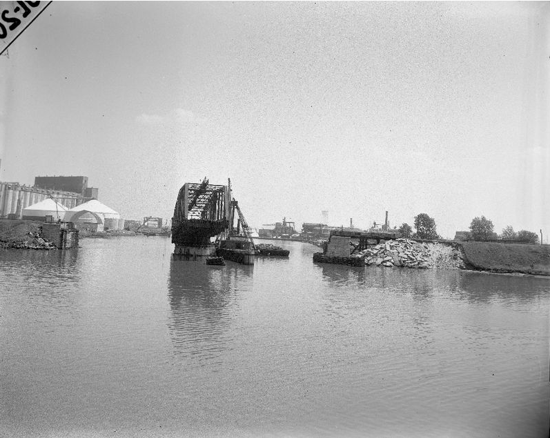
The Calumet Western swing bridge was removed after it was hit by an ocean-going ship in 1962. Here is the bridge shortly after the accident.

Bob Lalich Flickr

calumet western bridge damaged 5-15-62

Calumet Western RR swing bridge over the Calumet River sits askew after being struck by a ship in 1962. The CW was jointly owned by PRR, CRI&P and IHB. Arrangements were made to use the adjacent C&WI bridge after the accident. The swing bridge was dismantled and never rebuilt.


Marty Gatton shared


Marty commented on his share
From Rod Sellers


Dennis DeBruler commented on Rod's post
It is interesting to see how long it takes for a change to be reflected in the USGS maps. Bob Lalich has commented that the bridge was damaged by an ocean-going ship in 1962 and the route was changed to share the C&WI bridge. But the bridge still appears in this 1965 topo.
1965 Lake Calumet Quadrangle @ 1:24,000

Dennis DeBruler commented on Rod's post
The purple lines show the new tracks that were laid to allow the Calumet Western to share the C&WI Bridge.
1973 Lake Calumet Quadrangle @ 1:24,000
IHB continuing the operation of the Calumet Western explains why it bought the bridge when the C&WI abandoned this branch to Indiana.

When Calumet Western started using the C&WI bridge, they still had their Strauss trunnion bascule bridge.

A 1984 Bob Lalich Flickr photo
C&WI Mainline Bridge
The MP Hammond local passes over the C&WI Mainline bridge over the Calumet River, 8-84. 
Bob Poortinga 6y 
It is interesting that at this date, the C&WI uses one track on the bridge and the Cal Western uses the other.
Bob Lalich 6y 
This was after NS had acquired the C&WI between SL and 81st St. They quickly removed track 1 between SL and 110th St. Track 2 was removed when the Hammond Times moved the printing plant to Munster.
Bob Lalich 3y 
The CW connection to the C&WI was established after the CW swing bridge was hit by a ship in 1962. Here is what I have pieced together from various sources. Even before the CW bridge accident, plans had been drafted to replace the CW and C&WI bridges with a lift bridge in order to aid navigation in light of ocean-going ships using Lake Calumet harbor after opening the St. Lawrence Seaway. Replacing the NKP swing bridge was also part of the overall plan. It was decided not to repair the CW bridge after the 1962 accident, even though it would be years before the new bridge could be built and RoW obtained for the connecting track on the south side of the river. C&WI granted trackage rights to the CW between 123rd and 126th in 1964. I believe a temporary connection was established from the C&WI main south of the river to industrial trackage just to the east. A connection north of the river was built as well. This arrangement lasted until the lift bridge was opened in 1971. The C&WI lift bridge and the Torrence Ave bridge had separate operators.

Larry Candilas posted five images with the comment: "This is for those recently interested in the Calumet and Western swing bridge just downriver from the C&WI bridge."
Gary Siatka: The Calumet swing bridge had been struck by ships a few times. They rerouted to the CWI. This required the removal of roughly 10 houses
1

2

3
Randy Bosma: Note the "C&O Ry, of Ind." from/to Hammond. That's also known as the Hammond Belt Line RR. Very short lived; it was gone by the mid-1920s.

4

5

Larry Candilas commented on his post
Late 1930s

1 of 6 photos of the C&WI bridge posted by Larry Candilas