Showing posts with label towerBridge. Show all posts

Tuesday, May 6, 2025

1890 B&OCT Polk Street Tower

1890: (Satellite, Taylor Street used to have a bridge and go further East.)
New (1902 and/or 1949): (Satellite)
 
This would have been the tower built in 1890.
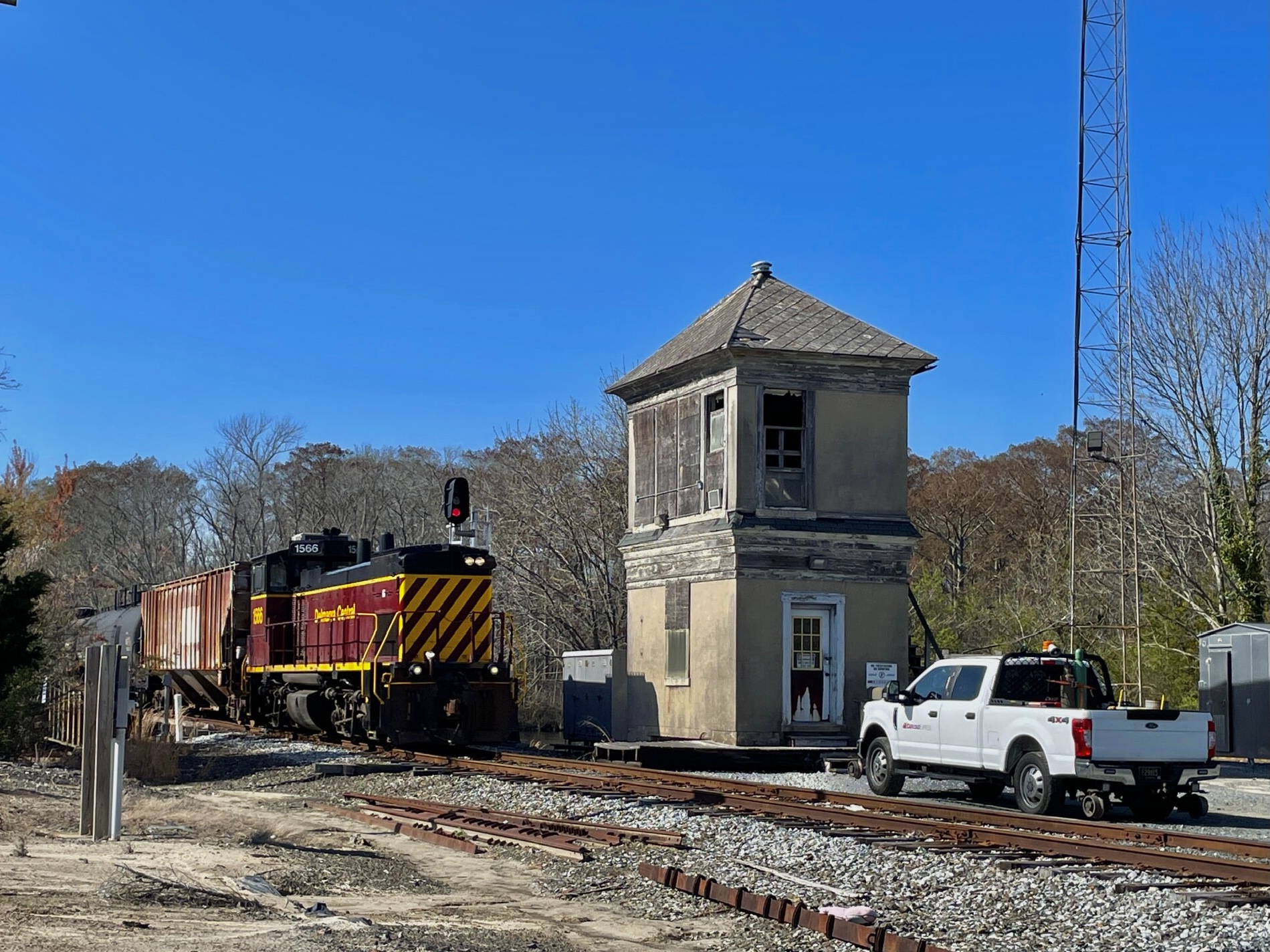
MWRD posted
A view to the east showing a bucket dredge in operation on the South Branch of the Chicago River near Taylor Street [Bridge] on March 22, 1917.
Dennis DeBruler shared with the comment: "That is obviously a railroad interlocking tower behind the cables of the shovel. According to the topo map that I added as a comment, it is a B&OCT tower. What would be the name of that tower?"
Jon Roma: At various times in the past, if I am deciphering the timeline properly, the CTT/B&OCT had a Polk St. tower, then a Harrison St. tower, and again a Polk St. tower.
Jacob Metzger: I believe this would be ‘Polk Street Tower.’

From that webpage:
"POLK STREET
Electric pneumatic interlocking installed 1890
New electric pneumatic interlocking installed 1902
New tower constructed/electric interlocking installed 1949
Tower controlled movements at Grand Central Station, closed 1969. Also controlled Chicago River bridge immediately southwest from 1902 until 1930, when river was straightened and new drawbridge built at 16th Street. New tower constructed in 1949 was closer to Roosevelt Road."

Clifton Linton: I don't think that's a B&OCT tower. Based on the date of the photograph (March 22, 1917), the B&OCT by this time had built an elevated tower that controlled the trackage for Grand Central Station and the twin-leaf Scherzer Rolling Lift Bridge.
Dennis DeBruler: Clifton Linton From Jacob's reference, we have:
POLK STREET
Electric pneumatic interlocking installed 1890
New electric pneumatic interlocking installed 1902
New tower constructed/electric interlocking installed 1949
So the 1902 "new electric pneumatic interlocking installed" must have also been a new tower, and the MWRD photo is of the 1890 tower. That would explain why the 1890 tower is labeled a "repair shop" in the 1906 map that Jon provided.

Dennis DeBruler commented on his post
1929/29 Englewood Quad @ 24,000

Jon Roma commented on Dennis' post
Here's a snippet from a 1906 Sanborn fire insurance atlas showing the area between Polk on the north, Fifth Ave. (Wells St.) on the east, Taylor St. on the south, and the river on the west.
Dennis DeBruler: Jon Roma In 1906, this must have been a regular interlocking as well as a "repair shop" because Jacob's reference indicates that the new tower about a block south of here wasn't built until 1949.

The upper yellow pin is labelled "B&O Polk Street (old)," and the white pin is labelled "B&O Polk Street (new)."
Map


Monday, April 14, 2025

1940 Delmarva Central/NS/Pennsy Bridge over Pocomoke Riverat Pocomoke City, MD and Cassatt Tower

(Archived Bridge Hunter; Bridge Hunter; no Historic Bridges; Satellite)

Street View, Jun 2023

A tree is hiding the open swing span.
Street View, Jun 2023

Al Tillotson posted four photos with the comment:
Still standing - former PRR CASSATT tower overlooks the Pocomoke River movable bridge in Pocomoke City MD, trackage now operated by Delmarva Central RR.
Views from Tuesday afternoon April 1, 2025.  Train is DCR’s SE-2 returning north to Seaford DE.
1

2

3

4

2018 photo by Timothy and Joann Phillips via BridgeHunter

Thursday, December 5, 2024

1917 Pennsy and Reading SOC Bridges over Darby Creek at Essington, PA

(Archived Bridge Hunter; Historic Bridges; B&TSatellite)


Street View, Oct 2018

"Significance: "Because Pennsylvania has few low-lying areas, the Darby River Bridge is one of a limited number of movable railroad structures in the state, and even more rare as an overhead-counterweight bascule bridge." [HAER_data]

HAER PA,23-EDDY,1--1
1. View looking south-southeast by 160 degrees, toward Delaware River. Philadelphia & Reading Railroad Bridge in foreground, Pennsylvania Railroad Bridge behind. - Philadelphia, Baltimore & Washington Railroad, Darby River Bridge, Spanning Darby Creek, South of Essington Avenue (State Route 291), Eddystone, Delaware County, PA

HAER PA,23-EDDY,1--2
2. View looking due east along Pennsylvania railroad, with bascule spans raised.

HAER PA,23-EDDY,1--3
3. View looking due east along Pennsylvania Railroad, showing underside of bascule leaf. Note that reduction gears and pinion operate rack mounted to bottom of girders.

Digitally Zoomed

HAER PA,23-EDDY,1--4
4. Perspective view, looking north-northwest at Philadelphia & Reading Railroad Bridge.

HAER PA,23-EDDY,1--5
5. Perspective view showing counterweights of both bridges and operator's house for Pennsylvania Railroad Bridge, looking southwest by 230 degrees. 

HAER PA,23-EDDY,1--6
6. Detail view, looking north-northwest, showing underside of counterweight and main trunnion bearing for bascule leaf of Philadelphia & Reading Railroad Bridge.

HAER PA,23-EDDY,1--7
7. Elevation view, looking south-southwest, showing bascule leaf, counterweight, and operator's house for Pennsylvania Railroad Bridge. 


Jonathan Konopka posted on Aug 28, 2022
These are the Darby Creek Railroad Bridges in Greater Philadelphia, PA.  They are a pair of bascule bridges that were built in 1917 and carry former PRR railroad lines over Darby Creek.  Photo is courtesy of HistoricBridges.org.
[Actually, the northern bridge carried the Reading Railroad.]

I got another Historic Bridges photo since Elaine Deutsch caught the Pennsy bridge in the closed position on Nov 3, 2014. Since there is more boat traffic than train traffic here, most photos catch the Pennsy bridge in the open position. Conrail abandoned the Reading route east of Eddystone, so that bridge is always up.
Photo via HistoricBridges (link at the top of the page)

Pennsy was north of Reading at Ridley Creek, but south of Reading at Darby Creek. 
1953/55 Bridgeport Quad @ 24,000

8th of 26 photos in B&T (link at the top of the page)

B&T (link at the top of the page), this webpage has a nice history as well as 26 overview photos.

Since the Reading bridge was abandoned soon after Conrail was formed in 1976, it still has its original interlocking machine and signaling pipelines. (The Pennsy bridge was converted to remote control in 2005.) The position-light blog has a lot of photos of the details of the Reading signaling equipment including these three photos.
a
The interlocking frame.

b
The guts of the interlocking frame.

c
Signalling pipelines controlling the rail locks.

Abandoned posted five photos with the comment:
The Darby Creek Bridges consist of two bascule spans crossing Darby Creek near Chester, Pennsylvania. Built in 1917, one bridge carried the Philadelphia & Reading Railroad (later the Reading Company) on its Philadelphia & Chester Branch, while the other served the Pennsylvania Railroad's Chester & Philadelphia Branch.
Today, one bridge remains in use by CSX Transportation and Norfolk Southern Railway. The other was abandoned in 1976 following the formation of Conrail.
1

2

3

4

5

Joe Brown posted five photos with the comment:
Known by the locals as fat Man's bridge 
In the 90s people used to jump off of it 
I think more recently people are just soft.lol or smart .
Delaware County Pennsylvania
1

2

3

A nice view of the closer overhead weight.
4

5


Sunday, September 19, 2021

1953 Aban/(Big4+Erie) and 1940 Carter Road Bridges in Cleveland, OH (OX Tower)

Railroad: (no Bridge Hunter?; Satellite, west lift bridge)
1940 Vehicle: (Bridge Hunter; HAERSatellite, east lift bridge) This bridge replaced a swing bridge.
Interlocking Tower: (3D Satellite)

The road bridge is down and the railroad bridge is up in this photo.
HAER OHIO,18-CLEV,37--1

1. VIEW OF EAST SIDE OF BRIDGE - Carter Road Lift Bridge, Spanning Cuyahoga River at Carter Road, Cleveland, Cuyahoga County, OH


It appears the lift bridge replaced a rolling bridge. The road bridge will be built in another decade.
Jonathan Konopka posted
Photo quality isn't great, but this is looking north at the old Big Four drawbridge along the Clark Branch in Cleveland (not the current one) in 1930. Photo credit belongs to Henry Wilhelm.
Dennis DeBruler: The tower on the B&O depot still has its peaked roof. Is that the trainshed of the B&O depot stretching between the bridge and the right edge of the photo?
Jonathan Konopka: Dennis DeBruler Looks like it.

Yep, this confirms it.
Jonathan Konopka posted
1949 - Looking east along the Cuyahoga River near Downtown. The USS Ossipee is seen tied to the bank of the river, and the Carter Road Bridge and NYC Railroad Bridge are also seen ahead. Photo is courtesy of the Cleveland Public Library Digital Gallery.
Jonathan Konopka shared
Cleveland in 1949, with the bascule NYC/Big Four bridge still standing.
 
LC-D4-70775 [P&P]

The railroad bridge is the narrow one, and the road bridge is the wide one.
HAER OHIO,18-CLEV,37--2

2. VIEW LOOKING SOUTHEAST SHOWING LIFT-TOWERS AND APPROACH ROAD


HAER OHIO,18-CLEV,37--3

3. VIEW OF NORTHWEST LIFT-TOWER AND APPROACH ROAD


Douglas Butler posted
Big 4 NYC Railroad Lift Bridge with Carter Road Lift Bridge in Cleveland, OH.
 
Thomas Ditty posted
Cleveland Ohio, Amtrak E-8 dated January 1979. From my personal slide collection. Photo credit James Marcus.

Dennis DeBruler commented on Thomas' post
The abandoned Big Four and Erie Bridge on the left and the Carter Road Bridge on the right. In the left background is the B&O #463 Bridge.
https://goo.gl/maps/jTBCuMijE2xEQvy88

Another photo that has a train on the bridge.
Scott Howard posted
1962, not sure why my grandpa took this shot, but thought I would share.
Brian Wolf shared
Cleveland flats 1962
[Some comments call this the Clark Branch.]
Thomas Ditty posted
A NYC crossing the now abandoned NYC lift bridge #2 in Cleveland Ohio. It’s quite rare to find older active shots on this bridge. It was posted on another page by a gentleman named Scott Howard, who said his grandfather took this photo in 1962. 
Tim Shanahan shared

Michael Murray posted
The Flats
Douglas Butler shared
Credit to Michael Murray Carter Road Lift Bridge and Big 4 NYC RR Lift Bridge Cleveland, OH.

C Hanchey, Jul 2012, via BridgeHunter, License: Creative Commons Attribution-NonCommercial (CC BY-NC)
 
Geoffrey Moreland posted
A rare shot of OX tower and the New York Central lift bridge Cleveland, 1964. Check out my group dedicated to Movable Bridges
Thomas Wentzel shared
Geoffrey Moreland posted

James Lattiemore posted
Douglas Butler shared
Credit to James Lattiemore Cleveland, Ohio's own Eagle Avenue [on the left] Carter Road and Industrial Flats [on the right] Lift Bridges over the Cuyahoga River.

Thomas Ditty posted
Truss & Rivets: Glad to see OX still standing
 
Jacqueline Crandall Fafrack posted
“OX (Oxbow)” / Flats tower in Cleveland on the former NYC Clark Branch over the Cuyahoga River-1981.

Geoffrey Moreland shared a post by Jacob Kniola of four photos and the comment: "Inside OX Tower in Cleveland back in 2017. Was able to get some shots due to some fallen boards."
1

2

3
[A motor-generator set. Do the relays and/or track circuits need DC power?]

4
Howie Castellucio: Wow that was a hot fire!!
[Note the steel beam near the upper-left corner that has snapped!]

David Daruszka commented on Geoffrey's share

Zachary Schroll posted two photos with the comment: "A blustery night and slow go at work offered a few minutes to shoot the Ex NYC Interlocking tower as well as Ex NYC Railroad Bridge no. 2 along the Banks of the Cuyahoga. Cleveland sure is full of Rich Railroad History!"
Geoffrey Moreland shared
1

2

Geoffrey Morland shared his post of three photos and the comment: "A rare shot of the “Big Four” vertical lift in Cleveland, Ohio in the down position. Photo taken March 1971. At one time this bridge carried the New York Central. This bridge was built in the 50s to replace a Scherzer type rolling lift, and has been abandoned in the up position since the 80’s. This bridge sits next to the Carter Road Vertical Lift and is still intact today. On the East Bank sat a large B&O freight house, with the operators tower still intact. A small approach span can be seen today on the West Bank.   Photo credit Lamont Downs/Jeff Leslie/C Hanchey"
1
Jim Arc: Tracks in the foreground were used by the NYC to get into and out of the Terminal, from Linndale. Today they are only used by RTA, to go out to Hopkins airport.
Jim Arc: Old B&O passenger station on the left. Control tower for the RR bridge is on the far right, towards the back.

2
[The brick of the control tower is peaking through the tree on the left.]

3
Jim Arc: The old B&O passenger station is in the background.

I'm surprised that Bridge Hunter doesn't have an entry for the railroad bridge since it is still standing. Based on some maps, the bridge carried Erie trains to a station just north of the river and Big Four trains to a connection with the NYC route along the lakefront.
This photo shows that the railroad lift bridge replaced a rolling bridge.
Cleveland Public Library Photograph Collection via BridgeHunterLicense: Creative Commons Attribution (CC BY)
 
10:20 video @ 3:16, Sep 24, 2013
[On the right, are they building a replacement span for the Carter Bridge?]

Michael Businger posted
 
Brian Shell posted
Douglas Butler shared
Credit to Brian Shell. Big4 NYC Railroad Lift Bridge detail located in Cleveland, OH.

New York Central Railroad Fangroup posted five photos with the comment: "The old Big 4 lift bridge is abandoned and locked in the up position over the Cuyahoga River in Cleveland.  The tower is overgrown and partially hidden.  For reference, the blue lowered bridge is the Carter Road bridge."
Jonathan Konopka shared with the comment: "More on the NYC Clark Branch bridge from the NYC Railroad group..."
1

2

3

4

5

Facebook Reel