These are notes that I am writing to help me learn our industrial history. They are my best understanding, but that does not mean they are a correct understanding.
We have traced sections of the Pennsylvania Canal (all of Susquehanna Division, Juniata Division, and Allegheny Portage Railroad), parts of Western Division, North Branch Canal, Susquehanna and Tidewater, Erie, Champlain, Blackstone, New Haven & Northampton, and more than half of Chesapeake and Ohio.
Each has been amazing.
Vince Gargiulo: So out of the group how many used inclined planes?
Metrotrails: Vince Gargiulo Morris Canal had 23, 24 if you count the electric one. I understand there was one connected to the Potomac. Other than that no inclined planes on the canals themselves. The early connection railways had them, but it wasn't the same. The most were on Delaware and Hudson Gravity Railroad. Second most on Pennsylvania Coal Company Gravity Railroad. Allegheny Portage Railroad had 10, Philadelphia and Columbia had 2. Lehigh and Susquehanna had 3. Mauch Chunk had 2 main, several connecting. Many early anthracite lines had them.
Comments on the above post
Comments on the above post
This is why the Erie Canal sparked such a canal building frenzy in the Midwest before the railroads made them obsolete.
Canal Societ of Indiana posted In Tippecanoe Co. Indiana, the Wabash & Erie Canal crossed Wild Cat Creek via the slackwater created by damming the creek just beyond the bridge. One of the abutments of that bridge is pictured [above]. As the bridge crossed the creek the mules walked along pulling the canal boats across the creek. There were guard locks on either side to be negotiated by raising or lowering the boats. These guard locks prevented flood waters from entering the canal. Learn more ar the website- Indcanal.org Selection box: Maps & Information Go to : 1876 Historical Map / Google Map with locations and descriptions of the historic canal structures. Get the canal history of this area with CSI Tour Guides - pages of information.
I've taken some photos of overflow weirs. But I don't have the time needed to try to find them. But I'll start these notes so that, if I come across a photo. it is easy to save it.
Canal Society of Indiana posted For a canal to function properly, the engineers designed them to maintain a constant level of water of 4-5 feet depth. Normally the problem was getting enough water into the canal but like a modern bath tub you had to have a way for the excess water to be safely released. On the Wabash & Erie Canal at Defiance, Ohio a waste weir was built into the bank of the canal. Once the water level filled to the opening, excess could be safely directed into a nearby waterway.
(Satellite, it looks like the abutments have fallen into the water)
Canal Society of Indiana posted In the 1830s, engineers on Indiana canals used two styles of aqueducts. Like the Romans they built stone piers on a solid foundation of either bedrock or on a platform of long timbers. On top of the piers a flume made of timber and lined with planks was built to create a watertight box to conduct the canal waters across a stream or river. This first type of aqueduct is called an Open Trunk Aqueduct. The attached drawing shows this style at the Aboite creek crossing in Allen County.
Dennis DeBruler commented on the post Was the route of the "Old Railroad Grade" on this map actually the route of the canal? 1961 Arcola Quadrangle @ 1:24,000 Canal Society of Indiana: Dennis DeBruler No the canal ran behind the Scout Center along Eagle Marsh - Towpath Trail etc. The Interurban ran on the old towpath. [They must have misunderstood the question. But they answer why the cartographer thought it was an abandoned railroad --- the canal route was reused by an interurban railroad.]
I have some specific posts about the Wabash & Erie Canal in my two blogs (see the "canalWE" label), but I don't have an overview. And I need an overview of the Whitewater Canal. This map is an excellent motivation for the overviews.
On this day in 1827, the United States Congress provided a land grant to Indiana to encourage the state to build the Wabash & Erie Canal. The canal would eventually reach Evansville and become the longest canal ever built in North America at 460 miles.
This 1939 map from Indiana Historical Society shows the completed and planned canals in the state of Indiana.
This is mostly the usual generic comments about canals. But it does say that in 1837 the Indiana legislature pass the mammoth internal improvements act. Starting here, he actually talks about the Central Canal. I remember 1837 because of the Panic of 1837. He does discuss that at 8:42.
On March 2, 1827, Congress provided a land grant to encourage Indiana to build the Wabash & Erie Canal. The original plan was to link the navigable water of the Maumee with the Wabash through the seven mile portage at Fort Wayne. Work began five years later on February 22, 1832, in Fort Wayne. Construction proceeded west as the canal reached Huntington by 1835, Logansport in 1838, and Lafayette in 1841. Work was also performed east toward Ohio, but the canal did not open to Toledo until 1843. A second federal land grant enabled the canal to reach Terre Haute by 1849. At Evansville, 20 miles of the Central Canal had been completed north by 1839. The Wabash & Erie Canal was extended south in the late 1840’s through the abandoned Cross-Cut Canal works to Worthington and then south following the old proposed Central Canal route. The connection with the Evansville segment was completed in 1853, forming the longest canal in the United States. By 1860, portions south of Terre Haute were closed and the process of decline continued northward. In 1876, the canal was auctioned off by the trustees; only 140 miles of the canal are still in use today....The canal was 40 feet wide at the berm, 26 feet wide at the bottom, and 4 feet deep. The berm was 6’ wide. The towpath was 10’ wide and was used to pull the boats with mules and horses at a speed of 3-5 mph. Mules were usually used, as they were stronger animals. The ropes used to pull the boats by the mules were 3” in diameter and 100’-150’ long. [Monteaum]
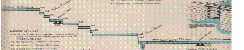
This chart shows locks needed for Wabash Erie Canal to reach from Lake Erie to the Maumee River and the summit in Ft. Wayne. The Wabash & Erie Canal was begun in 1832, constructing west from Ft. Wayne toward Huntington. In 1837 construction then began from Fort Wayne to the Ohio State Line and was completed by 1840. Ohio didn’t complete her portion of the canal from Toledo westward until 1843. The chart below shows that there were 29 locks and 108 miles of canal construction to reach the Ft. Wayne summit. The Maumee was a meandering river through the Black Swamp and was never really a commercial waterway. The dammed St. Joseph River, 6 miles above Fort Wayne, was the water source to feed the W&E Canal at the summit level.
Total
MILES LOCKS SEGMENT FT LIFT
30 9 Manhattan, OH - Grand Rapids 68
1 - Slackwater in Maumee river -
26 4 Grand Rapids - Independence Dam 32
4 - Slackwater in Maumee river -
9 7 Defiance - Junction OH 57
18 6 Junction - Indiana State Line * 28
20 3 State Line - Fort Wayne IN * 21
-------- -------- --------
108 29 Ft. Wayne - Manhattan, OH 206
* Portions of Black Swamp
137 miles - Maumee River = 179 feet total elevation
A summit canal is one that has a high level where the canal water flows in two opposite directions. As water only flows downhill due to gravity, a water source must be introduced at the summit level. Sometimes it is necessary to build a reservoir to retain sufficient water but when no water source is available that technique cannot be used. The Wabash & Erie has two summits. The first is the Ft. Wayne Summit. Another summit is located between Terre Haute and Worthington, Indiana on the “Cross-Cut” portion of the Wabash & Erie and is 78 feet high. Both water from this second summit coming into Terre Haute from the south and water from the north flow, into what is called the Nadir Level or lowest level.
New members joining our Canal Society receive the full profile map of the Wabash & Erie as partially shown above. See Indcanal.org website
Canal Society of Indiana – Wabash & Erie Canal Profile Map
S Water from Eel River - Terre Haute --- N Water from Parke County
When visitors see how long the Wabash & Erie Canal was, they sometimes ask where else they can go see it. The unfortunate truth is that we are one of the VERY few spots along the full route where you can clearly see the canal as it once was! The canal brought extensive and rapid change to Indiana, and yet it is a "hidden wonder" today. Here are a few quick examples of how the Wabash & Erie transformed the Hoosier State:
Pre-canal, the Upper Wabash Valley had approximately 12,000 total inhabitants. By 1840, when the canal reached Delphi, the region's population had exploded to 270,000!
When shipping by wagon, a farmer could count on paying 15-25 cents per ton per mile to ship their goods. On a canal, that cost became 2 cents or less! You can imagine how an industry could be revolutionized when shipping speeds skyrocket while also decreasing in cost by 90%
In 1849, the canal reached Terre Haute. Within two years, the city's population doubled.
But if you're a sleuth and ynullou want to track the route of canal, check out the interactive Google Maps feature that the Canal Society of Indiana has on their website: https://indcanal.org/maps-statistics/wabash-erie-canal/ Click the county you'd like to view, then click "Google Map" to see the route over a modern map, with markers for notable features and structures. And the most intriguing part: many of the structures are "unconfirmed," meaning we have a guess about the location, but there are still archaeological mysteries out there!
When you walk our historic trails and visit Canal Park, you get the rare opportunity to witness an engineering marvel that is still magnificent even 150 years after its closure!
STATISTICS: from research of Tom Castaldi, Ronald E. Shaw, and Harry Sinclair Drago
Ramona Seese Thornburg: I always thought the canal just connected up to the Wabash River west of Delphi and then it is was "smooth sailing" to the Ohio River and the Mississippi. I guess I need to visit the museum again and study the maps more. Thanks for sharing this visual. Wabash & Erie Canal Park: Ramona Seese Thornburg Our pleasure! The full scope of the canal wasn't known when the project started, so you weren't entirely incorrect! The initial plan was to link the Maumee and Wabash Rivers, using the canal as a sort of "connector" for where steamboats couldn't reach. However, after construction had begun, Indiana took on a massive infrastructure loan and the project grew exponentially in size and cost. The extensions to Terre Haute and later Evansville were fueled as well by Federal land grants that seemed like "free money/land" for Indiana. When Terre Haute was reached and the orders came down to extend all the way to Evansville, nobody was more surprised than Jesse Williams, the chief engineer for the project! With the canal completed, you could ride in a single boat for 7-9 days, pulled by mules, and travel from Evansville to Toledo (or vice versa). Canal Society of Indiana shared
"As settlers moved into the old Northwest Territory after 1800, transportation routes became an important priority. Indiana’s brief experience with canal building began with the passage of the Indiana Mammoth Internal Improvement Act of 1836. Whitewater Canal was one of several projects funded by this act. The Whitewater Canal started in Lawrenceburg and originally ended at Cambridge City, on the Old National Road. Hagerstown merchants financed an extension to their town, making the canal 76 miles in length. The state of Ohio also built a 25-mile spur linking Cincinnati to the canal. Along the canal, 56 locks accommodate a fall of nearly 500 feet." [IndianaMuseum] It reached Brookville, IN, in June 1839. [IndianaHistoricalBureau] It was at Connersville in June 1845 and by Oct a boat had reached Cambridge City. [Video] The map below shows that it reached Hagerstown in 1847.
Because a lot of water-powered industry had developed along the canal such as the mill that still exists in Metamora, the canal was maintained until the 1950s to supply water for industries in Brookville, IN.
Canal Society of Indiana posted The second type of aqueduct was the enclosed or covered bridge type. The construction is the same as the open trunk. Then the structure is enclosed with a wooden frame above to protect the timber frame that is exposed to weathering in the open trunk style. There is a total of 20 aqueducts on the Wabash & Erie Canal in Indiana, but only 5 were roofed and enclosed. The longest, 510 feet long, was across the White River near Petersburg. It was roofed. On the Whitewater Canal there were 2 aqueducts. One crossed the Whitewater River just south of Laurel, and the next was at Duck Creek as shown in the photo below [above]. Kirk Patrick Shorter: There is a 3rd on the canal.... very small & easily missed. It is at the area of Goose Creek.
Doug Arthur posted three images with the comment: "My Mentor Paul Baudendistle put together a map of the Whitewater Canal and called it 'A Key to the Locks'."
1
2
3
He shows lock #24, and then he gives a history of the canal.
Doug Arthur posted a PDF download link with the comment: " I made a PDF of the entire project. It was researched and put together by the foremost authority on the Whitewater Canal Mr. Paul Baudendistle from Metamora Indiana. All the credit goes to him and please don't use any of this without crediting Paul."
The 1895 NKP bridge was south of the 1904 bridge. NKP continued to use the 1895 bridge for passenger trains. [ArchivedBridgeHunter_1895]
The satellite and street views would be of today's NS/N&W/NKP bridge. This 1889 bridge would not be able to hold the "big steam locomotives" that NKP ran in the 20th Century.
Great Memories and History of Fort Wayne, Indiana posted
St. Mary's River from west Main Street bridge, 1889, showing stone factory or mill with smokestack by iron bridge. ACPL Matt ReibsRiver Greenway to the left, parking lot to the right in modern times. [Since the NKP used the right-of-way of the Wabash and Erie Canal, there probably was an aqueduct here over the St. Marys River in the mid 1800s. (Update: Tom's History describes the mill and the covered aqueduct that proceeded this bridge.)]
Becky Osbun also posted Rick Brandt The view is looking North. The trestle seems farther away, I think, because the original Main St bridge was farther South than today's bridge. Randy Harter This is the Orff Mill, however, it had other names/owners over the years. The mill was on the east side of the St Mary’s, just south [actually, north] of the Main St bridge. The tiny triangular shaped park there on Main with the statue of the boys who swam in the aqueduct is sitting in the eponymous Orff Park. While this was originally an overshot mill driven by water diverted from the Wabash & Erie Canal (which closed in 1874) in this photo we can see the smokestack indicating it was has been converted to steam engine.
1 [The "trail view" below confirms that the bridge in the background is Sherman Blvd.]
2 [The St. Marys River was running high.]
Becky Osbun commented on Chris' second post After finding out my grandparents lived on nearby Herman St. in the 30s-40s, I wanted a closer look.
Jordan Carnes commented on Chris' second post Here’s the last aerial view of it before it was torn down.
Seated upon cut stone abutments and wingwalls, this single-span pin-connected Camelback is divided into seven panels by verticals of reverse channels laced to one another. The heaviness of the structure is evident in the crafting of the channels and the cover plates used for the endposts and top chord. Heavy diagonals (reversed laced channels) pinned midway into the endposts stabilize the abutment panels which are of different size to adjust for off-setting the south truss by about 6' to the west. The use of cylindrical and die-forged eyebars as diagonals in the three center section panels is reversed in the opposite truss: Double die-forged eyebars are countered with cylindrical ones with turnbuckles (doubled in the most central panel). The top chord for each of the two side panels has a different slope. The typical and yet heavier double die-forged eyebars angle from the top pins downwards towards midspan, although the panel close to the center section also has an adjustable counter. The heavy girder floor beams are riveted to the vertical above the lower chord. They, in turn, have heavy girder stringers riveted to the floor beams.
The bridge carries double tracks
[ArchivedBridgeHunter_1904]
The following shows the cut stone abutments and wingwalls.
Kenneth Childers posted
Wells Street Bridge over the St. Mary's River [posted by Downtown Fort Wayne, facebook, 2017-07-30]
[A lot of comments agree with Kenneth that this is the Wells Street Bridge, but clearly, it is the NS/NKP Bridge. The bridge in the background is the Main Street Bridge because of the concrete arches.]
Photo from Kenneth Childers' posting
'Wabash and Erie Canal aqueduct at Fort Wayne' [Pictorial History of Fort Wayne Griswold 1917]
Great Memories and History of Fort Wayne, Indiana posted
Photo of the painting by Ralph Dille of the Wabash and Erie Canal Aqueduct over the St. Mary's River at Fort Wayne. Aqueduct also known as the St. Mary's Aqueduct. 1882.
Chris Gleason posted
[Fortunately, the comments confirmed it was this NS/NKP bridge.]
Canal Society of Indiana posted The St. Marys aqueduct in Fort Wayne was only 160 feet long and was roofed. The enclosed diagram shows the aqueduct, the large basin to the west and the Orff Mill that operated using the water from the canal. The canal water came from the St. Joseph River via the 6½ mile feeder canal.
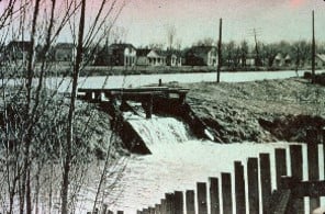
Canal Society of Indiana posted Pictured here ice is destroying what little remained of .Ft Wayne’s St Marys aqueduct. As shown it is just south of today’s railroad bridge. The view is from the east side looking west. The new sign that CSI just has placed is located just below the men standing on the west side.
Carol Langley posted five photos with the comment: "This abutment is all that remains of the aqueduct that carried the Wabash & Erie Canal over the St Mary's River in Fort Wayne. Eternally overshadowing it is the very thing that led to its demise...the railroad. This 1904 steel railroad bridge is still in use. I took these pics in the summer of 2022."

%20Metrotrails%20-%20A%20good%20overview%20of%20the%20historic%20canals%20of%20the...%20_%20Facebook.png)
%20Metrotrails%20-%20A%20good%20overview%20of%20the%20historic%20canals%20of%20the...%20_%20Facebook.png)