Showing posts with label rrWC. Show all posts

Saturday, May 11, 2024

Three SOO Crossings over Mississippi River and CN Steam Locomotive

1909 Blanchard Dam: (Archived Bridge Hunter; no Historic Bridges; Satellite, it is now a trail)
1905,1936 Camden Place: (Archived Bridge Hunter; Historic Bridges; Satellite)
They shared the Great Northern Bridge for their southern crossing of the Mississippi. Since that would have been for passenger trains, that crossing is no longer used.

See "The Rest of the Story" below as to why I researched three bridges at the same time.

Michael Kam posted
Crossing the Soo Line Bridge over the Mississippi, 12:50p [May 3, 2024]
[CPKC Empress 2816 heading to Chicago for a May 8 exhibition.]

Digitally Zoomed
.

Blanchard Crossing Bridge


BridgeHunter_blanchard
"Built in 1908 as part of the line from Brooten to Duluth; railline discontinued in 1993; rehabilitated for recreational use in 2006; reopened as a bike trail in 2007"
.

Camden Place Bridge


The bridge is 904' (276m) long with a main span of 125' (38m). [BridgeHunter_1905]

River View, Sep 2016

I presume they used a suspended steel girder span to increase the clearance over a navigation channel.
River View, Sep 2016

Street View, Jun 2019

The Rest of the Story


When I read the description on the Facebook post at the top of these notes, I did a search of the blog for the labels "wwMiss,rrWC", and got an empty result. So I did some research and found a Soo map.
Huntington

Since the Soo crossed the Mississippi in three places, I wrote a comment on the post asking for the location of the bridge in the photo. Unfortunately, when I submitted the comment, I got:
When I clicked the "Try again," I got the same result. After a few times, I was implementing the definition of insanity. (Keep trying the same thing with an expectation of a different result.) And then it would just hang with a "spinning circle." So I went on to plan B: document all three bridges. The crossing at Bowlus was easy.
For the two crossings at Minneapolis, I started with a "Minneapolis South" topo. I could not find any Soo tracks in that quadrant, so I got a "Minneapolis North" topo. That was a winner.
1952 Minneapolis North Quad @ 24,000

Satellite

Because of the suspended steel girder span in the middle of the bridge, it is easy to conclude that the Soo Line Bridge is the bridge in the photo. Camden Place is the northern neighborhood of Minneapolis. Since the Soo tracks are not labeled in the "Minneapolis South" topo, I got the topos "New Brighton" and "St Paul West," but I could not find the southernmost crossing in them. I suspected that they shared a bridge with someone else for their passenger service to Minneapolis and St Paul depots. Then John Marvig in Bridge Hunter and Historic Bridges provided the information that, indeed, the track going south in the "Minneapolis North" map connected to the Great Northern route across the Mississippi River.

Facebook Event
The train pulled by the steam locomotive is scheduled to be in Chicagoland on May 8, 2024.

The train left Calgary and is on its way to Laredo.
cpkcr

The Empress 2816 is a Hudson (4-6-4) type locomotive.
kuula

Tuesday, September 19, 2023

1887 O&StCV/CN/CP/SOO/WC Bridge over St. Croix River not near Osceola, WI

(Bridge Hunter broke Mar 22, 2023; Satellite)


Redeker Rail Video & Photography 0:39 video
SOO Line GP7 crosses the St.Croix River on the Osceola & St.Croix Valley Railway. 9/11/2023
Terry Redeker shared

Dennis DeBruler commented on Terry's share
https://maps.app.goo.gl/kiNrz5LQgp4frnGh9

David Zeman Photography posted
GN #325 (EMD SDP40) heads east over the St. Croix River with its matching trainset near Osceola, WI. 
9/13/2023
Tim Shanahan shared
Dave Zeman shared

trains, Steve Glischinski 2008 photo
CN still owns the tracks. The truss span of this 1887 bridge used to pivot. The bridge is 675' (206m) long.

1:06 video @ 0:58

1992 Osceola and St. Croix Valley Railway

Osceola and St. Croix Valley Railway is a tourist railroad that is a wholly owned subsidiary of the Minnesota Transportation Museum (MTM) and the Osceola Historical Society. It runs excursion trains from Osceola, WI, to Marine on St Croix, MN, and to Dresser, WI. It also has operating rights to Withrow, MN, which it uses for special trains throughout the season. [4:28 video]

The MTM offers a variety of train rides.

Redeker Rail Video & Photography 0:39 video
SOO Line GP7 crosses the St.Croix River on the Osceola & St.Croix Valley Railway. 9/11/2023
Terry Redeker shared

At least one exhibition train includes a demonstration of a RPO snagging a mailbag.
4:28 video @ 2:44

This railway runs on what was the original SOO/Wisconsin Central mainline until the 1980s.  Now CN runs just one ballast train a day that hauls rock from a quarry in Dresser. This ballast train was captured before Canadian Pacific sold the SOO line to Canadian National.
4:28 video @ 2:44

The railroad has preserved freight cars as well as passenger cars. And some train rides cross the St. Croix River on this 1887 swing bridge, which no longer swings.
4:28 video @ 3:54

Winthrow is in the lower-left corner and Dresser is in the upper-right cornfer. Saint Croix is now Marine on St. Croix.
1955 Stillwater Quad @ 250,000


Saturday, January 1, 2022

Watco's Fox Valley & Lake Superior Rail System (FOXY)

Rich Karding's post taught me about this CN sale to Watco. A comment on the post provided the FOXY reporting mark for the new railroad, Fox Valley & Lake Superior Rail System, created by Watco to operate these assets. Several of the comments give insight about which customers CN was unable to drive off of their branch lines by providing bad service. The red+blue lines for joint operation must not show up properly on the map because I could not find any. And because FOXY surely has connections between its various blue segments. Of note, WSOR is also a Watco railroad.
Watco via Trains

I was surprised that the map did not show a route to Chicago. I'm sure that CN does not use WSOR to gain access to Chicago. So I found a CN map to show a more complete network. A capacity map is useful because it effectively documents the routes that CN cares about, i.e. the green lines. I wonder if the route to Canada via Sault ste Marie is a lightweight route by today's standards because of the several bridges needed to cross the shipping channels and St. Marys River. Otherwise, I would think that CN would care about that route.
CN

While I was looking for a CN map, I found this diagram. It is worth noting.
Pinterest


Monday, May 31, 2021

CN/WC Bridges over Echo Lake in Burlington, WI

(no Bridge Hunter; Satellite)

I can't believe that Bridge Hunter doesn't have this bridge considering they do smaller bridges such as overpasses. Maybe this is the railroad equivalent of an Ugly Concrete Eyesore Bridge (UCEB). Bridge Hunter doesn't seem to allow them on their web site. But a bridge further south identifies this route as CN.
Street View

So why am I doing a UCEB post? Because CN is replacing the spans.
Brian Cazel posted
Looks like CN is going to do some major bridge work, at Echo Lake, in downtown Burlington, Wisconsin. Not only is the very large crane in position, there's a lot of equipment in play just off to the right. 4-24-21.

It looks like steel girders are getting replaced with precast concrete girders. Or maybe the new spans have steel girders that are freshly painted grey. Note the new spans are prebuilt with everything, including handrails. 
Screenshot @ 1:35/1:42

At 1:05 the crane starts sounding a periodic alarm. Brian indicates it is a warning alert that indicates the crane is doing a movement other than lifting straight up. Kind of like the beeping we now here when a vehicle with poor visibility backs up. The movement is so slow that it is hard to detect. I think he is lifting his boom to shorten the radius to make swinging the span over to the staging area safer.

Wednesday, January 6, 2021

Illinois Central's Riverside & Harlem Railroad (Forest Park Branch)

The information for these notes comes from two Facebook postings: Chicago Railroad History and B&OCT.

William Shapotkin asked about the "Forest Park Branch" of the Illinois Central:
The Illinois Central once operated a line, which I understand was  known as the "Forest Park Branch." The line began at "Parkway" (26th St  west of Harlem Ave in North Riverside, IL) and headed north connecting  with the   present-day CSX (of course, we know it as B&OCT) just  north of Harrison St in Forest Park, IL. The IC referred to the north  end-of-line as "Harlem Jct," the rest-of-the-world referred to it as  "Great  Western Jct."
The line is now abandoned -- but some eight  years ago, I was able to follow and photograph the line from Parkway  north to 15th St (where the track ended). Does anyone know when the line  was removed north of 15th St? Courtesy of a fellow (Bob Lalich), we  know the line was still intact as of 1942 (see track chart below). If  anyone can shed some light (and even better a few photographs) of that  line north from 15th St -- MORE ESPECIALLY the at-grade xing of the IC  and the Chicago & West Towns streetcar line at Roosevelt Rd (aka  "12th St"), it would be greatly appreciated.
Many thanks.
Provided by Bob Lalich

David J. Leider explained:
The original name for the line was the Riverside & Harlem Railroad. It was used by the Wisconsin Central to get to the IC's lakefront station. The WC was going to build the line, but the IC insisted as they wanted to gain access to the Harlem Racetrack, which was just west of the Right-of-way. The line was incorporated April 10, 1901. Capital stock $200,000. The Village of Harlem granted them an ordinance to build the line on July 5, 1901. It was open August 30 after a skirmish with the Chicago Terminal & Transfer about crossing its tracks. The IC purchased the line October 1902.
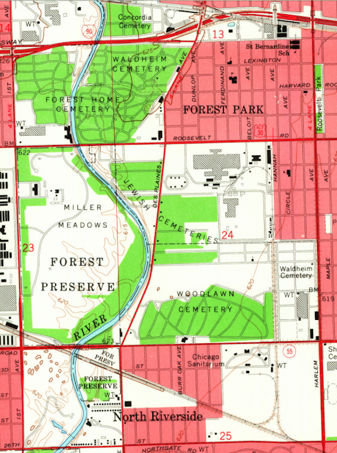
This 1953 topo map shows what the branch looked like when it was intact.
1953 Berwyn Quadrangle @ 1:24,000
Provided by Dennis DeBruler

By 1963 it had been cut back so that it no longer crossed Roosevelt Road.
1963 Berwyn Quadrangle @ 1:24,000
Provided by Dennis DeBruler

By 1972, a spur had been added for an industrial park north of Woodlawn Cemetery. The track configuration was the same in the 1980 map, but there were more buildings in the industrial park.
1972 Berwyn Quadrangle @ 1:24,000
Provided by Dennis DeBruler

By 1993, the tracks had been removed by the Forest Park Mall.
1993 Berwyn Quadrangle @ 1:24,000
Provided by Dennis DeBruler

The last map available is 1998, and it still shows the track going north of 15th Street. I noticed that today none of the buildings in the industrial park have rail service because the track south of 15th Street has been removed. Today there is more track on this branch north of 15th Street than there is south of it.
Provided by Dennis DeBruler

The guy that drove the Google street car in this area must have been a railfan.
Provided by Dennis DeBruler

Matthews and Mann provide some insight into the industry that used to be along that branch.
Facebook

Andre Kristopans explained that when SOO (one of the many corporate names for this Wisconsin Central route) moved from Central Station to Grand Central Station, it no longer used this route. "When they went back to Central again (early 60s?) they used IHB down to Broadview."

I've lived in the western suburbs of Chicago for over four decades and never heard of Broadview. Looking at a map, I see I drive by it every time I'm willing to test the severity of the traffic jams on I-290. I highlighted in red the IHB route used to connect WC/CP/SOO/WC with IC.
Satellite plus Paint


Monday, June 8, 2020

Grayslake Junction: (Metra+WSOR)/Milw vs. (CN+Metra)/WC

(Satellite)  


I'm still learning about the Chicagoland railroads one junction at a time. And researching this junction taught me something more about Metra routes.

Rob Conway posted
Another view of the Grayslake diamond replacement in 1976.
Mike Heiligstedt All that and a Fairmont !! [The speeder on the right.]
Sam Carlson Watching jewelers mount a diamond!

Metra's route on the former Milwaukee tracks is Milwaukee District North (MD-N). Metra would own this route in its service area. I presume that WSOR would own the rest of the route and provide freight service on the Metra part.

Metra's route on the former Wisconsin Central tracks, North Central Service (NCS), is complicated because the WC tracks between the BRC and the loop are either out-of-service or no longer exist. And they are owned by B&OCT, which is now owned by CSX.

I looked at using this topo map to document the lost WC route. But it has the serious error of showing the B&O (actually, B&OCT) route turning south and joining the Pennsy route rather than continuing across the river and turning north to the Grand Central Station.
1953 Chicago Quadrangle @ 1:250,000

The 1957 1:250,000 topo had the same error. But the 1980 version below accurately shows the B&OCT/WC route to the Grand Central Station. I used the following color code.


1980 Chicago Quadrangle @ 1:250,000 plus Paint
So I checked a Metra map to see how the North Central Service trains get between the WC tracks and Union Station.
Metra-NCS
The answer is that they use the Milwaukee District West (MD-W) route, which Metra owns, until they get to the B-12 Junction (red oval on map) and turn North onto CN/CP(Soo)/WC tracks.
Metra-ND-W plus Paint

NCS is obviously the Metra route that provides service to O'Hare. It has a station that is a couple of blocks from the People Mover terminal that supports some rental car companies. I remember that it took a while after Metra was created to get this route running. In fact, the first regular service train didn't run until 5:27am on Monday, August 19,1996. [History-NCS] Unlike the other routes where railroads were running commuter trains for over 70 years before 1996, the Wisconsin Central did not have commuter service. It was not built to create suburbs like some other routes were (e.g. MD-W's Chicago & Pacific [History-MD-W]). It was built to connect the WC to the Chicago freight market. So $131.4m had to be spent to get the 53-mile route ready for commuter service. The towns along the route helped pay for the stations and parking lots. Shortly after Metra was formed in 1984, they began planning this route. In 1987, Soo, a subsidiary of Canadian Pacific, sold the line to a new corporation that revived the name Wisconsin Central. Canadian National obtained ownership of the line in 2001. "Rails and signals were upgraded to allow for 60-mph commuter trains. Sidings were added or elongated so freight trains could move out of the way of commuter trains and vice versa. Gates were upgraded at 69 crossings and rebuilt at 23 crossings." Between 1997 and 2006, Metra spent $218m to add a second track and four more stations. [History-NCS]

Monday, April 13, 2020

CN/(ELS+WC+C&NW) Bridge over Escanaba River at Escanaba, MI

(Bridge Hunter; Bridge HunterSatellite)

ELS = Escanaba & Lake Superior Railroad

Why make yet another truss bridge posting?
  • It has rather modern (1945) spans with a quadruple warren (lattice) design
  • It has been replaced
  • Creative Commons photos are available
  • These notes allow me to fix misleading information in some ore dock notes

C Hanchey Flickr, License: Creative Commons Attribution-NonCommercial (CC BY-NC)

Soo Line Escanaba River Bridge


1892 double-intersection Pratt through truss railroad bridge over the Escanaba River in North Escanaba, Michigan. The was built for the Chicago and Northwestern Railway (CNW) and is currently owned by the Canadian National Railway (CN).

I'm not surprised that C&NW built the bridge because we have seen other C&NW bridges that have this quadruple warren design. With the exception of a terminal railroad in Morris, IL, C&NW and Rock Island were the only railroads that I have seen use this design. I've also seen this design called a "double lattice."

Greg Mross posted
WC 6619 leads an empty ore train across the Escanaba River at Wells, MI in May of 1997. The weather is damp and dreary but the scene can't be repeated today as the WC is gone, the ancient bridge has been replaced, and the ore dock in Escanaba has been closed. It was also a bit surreal after shooting so many C&NW trains here.
Pete Schierloh: Despite being despised in some circles for it, I will admit here that I am the engineer that designed the replacement spans for this bridge. I defend my actions as simply completing the job the C&NW started, but was interrupted by the war department and rationing of steel during WWII. The C&NW had identified the old truss spans for replacement prior to WWII, but by time the need became desperate during the war the war department wouldn’t authorize new girders. They did allow the installation of new piers and modification of the old truss spans, effectively cutting the spans in half. The C&NW built the new piers low enough to accommodate the future installation of deck girders after the war. It ended up being 70 years after the war, but better late than never. As it was, the 1940’s “new” piers required very little modification to allow the installation of the new deck girders in 2015.
This isn’t the only place that the C&NW did this type of truss to girder modification. The bridges on either side of Boom Island in Marinette/Menominee were modified in the same way prior to the war.
Anyway, the bridge certainly looks a lot different these days, but it is more robust.
One last tidbit. I was onsite when the last truss span was replaced and the last train over the bridge had a caboose for whatever reason. I thought it fitting the last car to roll over the bridge that day was a holdover from an earlier era in railroading like the truss that carried it one last time.
George R Widener: Technically the WC still exists, we’re just a paper subsidiary of CN. 
Greg Mross: George R Widener Just like the GTW and others....
George R Widener: Greg Mross Exactly. It's weird, most administrative and benefits are handled by the IC; and my paystubs come from the Grand Trunk Western. Yet my seniority is only valid on the former WC. It carries over to the DWP, DMIR, and EJE as those three were officially merged into WC by CN but I'd fall behind any protected pre-merger engineer. Gotta love it!

Postcard via Escanaba Postcard Museum via Historic Bridges and Greg Mross commented on his post
Rob Pfeiffer: Greg Mross And the highway bridge shown on the postcard was also has an interesting history. Built in 1911, closed due to structural issues in 1949, stood idle until 2015 when it was finally removed. It was a good photo platform though. https://www.youtube.com/watch?v=ueJ_rBthA04

The above postcard and others on eskycards show that the derelict bridge used to be a road bridge. In fact it was a previous route for US-41. The postcards also show that the abandoned piers used to carry an interurban route.

Satellite
[This image is proof that Google Map's change to copyright "Imagery" as 2020 is bogus. Because the truss spans were replaced with steel girders in 2015. In fact, Goggle Earth dates this image as Oct 10, 2013.]
Note in the postcard image above that the original 1892 bridge had just four piers. We can see in the satellite image that those piers are much older than the ones added in 1943 because of the land and vegetation built up around the base of the piers. The photo below shows that the new piers that were added to halve the length of the new spans are simply bents using steel piles. The photo also captures one of the abandoned piers of the interurban bridge. The derelict US-41 bridge is visible under the cords of the railroad bridge.
Jann Mayer Photo via Bridge Hunter, License: Creative Commons Attribution (CC BY)

The "new" piers were having problems.
C Hanchey Flickr, License: Creative Commons Attribution-NonCommercial (CC BY-NC)

Soo Line Escanaba River Bridge


Historic Soo Line Escanaba River Bridge in Delta County, Michigan. The bridge was originally built with five spans supported by stone piers. In 1943, the bridge was modifed by adding intermediate bents and dividing each span into two - creating the current ten span bridge


It looks like they did not have to do any repairs to the stone-cut piers, just notch them to make room for the deck girders of the 2015 replacement. But they had to replace the concrete caps of the bent piers. They did get rid of most of the vegetation around the old piers.
John Marvig Photo via Bridge Hunter

Greg Mross posted
CNW 6916 brings an ore train over the ancient bridge crossing the Escanaba River (and E&LS) in Escanaba, MI in June of 1988. The SD40-2's replaced the Alco 628's and were quickly replaced by SD50/60's. Today, the CNW is gone, the bridge has been replaced, and the ore dock in Escanaba is no longer used.

Eric Kurowski posted twelve photos with the comment:
ESCANABA BRIDGE.ORIGINALLY built for much longer spans . The old spans were built for lighter trains but as iron ore tonnage grew in the region. The longer spans took a beating with the old wrought Iron Rivets. New short spans built heavily with harder rivits was needed to take the loads of heavy locomotives and short heavy ore cars that made the weight very compact. The need was met with theese spans.A very unique bridge indeed.
1
[Note the wood piles driven in front of the old stone piers. Was this to reduce the flow around the old piers? Or to move the scouring from the base of the piers to the base of the piles? Neither John's photos or this Flickr photo catches a view of the upstream side of the new bridge so I don't know if they kept the wood piles in front of the old piers.]

2

3

4

5

6

7

8

9

10

11

12

Bing Maps not only shows the steel girders, it shows that the derelict bridge has been removed. This is the first time in my experience that Bing has had newer satellite images than Google.
When I tried creating a URL for this excerpt, Bing Map had a popup with "Creating the link ..." showing in a field during the entire time that I played a Freecell game. So I tried, but Bing failed.

The replacement bridge.
Brian Caswell Train Photography posted
A pair of CN SD60's lead a manifest train across the Escanaba River in Escanaba Michigan (Upper Penninsula) on a rainy Friday afternoon - Westbound / 10-6-23
J.B. Rail Photog shared

A video clip of a Wisconsin Central ore train going over the bridge   This shows how short the ore cars were because ore is significantly heavier than coal, grain, etc.