Wednesday, May 31, 2023

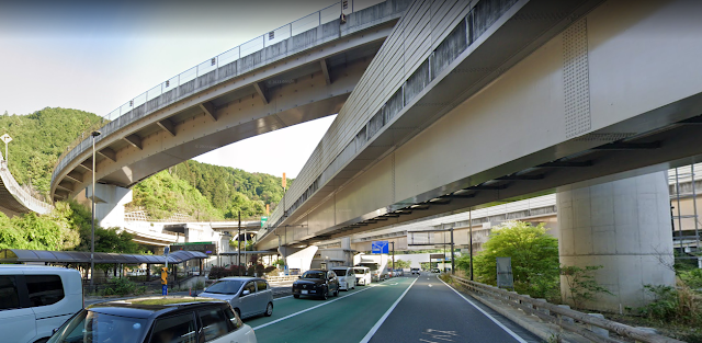
A Highway Interchange In The Takao Mountain - Near Tokyo, Japan

(Satellite)

I figured out that there are so many ramps because they wanted to build just one set of toll gates.

Highway Engineering Discoveries posted
A Highway Interchange In The Takao Mountain - Near Tokyo, Japan
Civil Engineering Discoveries posted
Amazing intersection in Japan ..

This photo has been flipped. That is, it is a mirror image and a mistake.
Highway Engineering Discoveries posted
Highway interchange in Japan

This is looking in the other direction across the interchange.
Highway Engineering Discoveries posted
Japan

World's Most Attractive Destination posted
Japanese Highway Interchange Aerial ! A Pic by fan Thank you "Wirote Kctech"
 
Highway Engineering Discoveries posted
Japan

I should use the label bridgeGirderSteel instead of bridgeGirderConcrete.
Street View, May 2023

I couldn't figure out how to turn off the labels in Google Map, so I switched to Google Earth.
Google Earth

I zoomed out to see how extensive the three tunnels are.
Road Map

I noticed that the next intersection to the North on 468 looked complicated, so I checked it out.
Global Earth, Mar 2021

In this case, the labels help figure it out. It looks like the roads are designed to send more traffic north than south.
Satellite


Tuesday, May 30, 2023

1929 NS/Sou/CNO&TP/CS over Kentucky River at High Bridge, KY

(Bridge Hunter broke Mar 22, 2023; Satellite, 207 photos)

To explain the title, Cincinnati built and owns the Cincinnati Southern route, but it now leases it to the Cincinnati, New Orleans & Texas Pacific (CNO&TP), which is a wholly-owned subsidiary of Norfolk Southern.

The previous bridges, 1877+1911, are documented here.

OnlyInYourState, Wikimedia/Rsfinlayson
"High Bridge opened as a part of the Cincinnati Southern Railway in 1877 and soared at a height of 275 feet and 1,125 feet long. Over a century later and the bridge continues to stand as one of the tallest and most impressive in Kentucky.
"At the time it was built, High Bridge was the tallest bridge above a navigable waterway in North America and the tallest railroad bridge in the world until the early 1900s."
Kentucky Living Magazine posted
On this day in 1877, workers completed High Bridge, connecting Jessamine and Mercer Counties over the Kentucky River Palisades. It was the tallest bridge above a navigable waterway in North America (275 feet) and the tallest railroad bridge in the world until the early 20th century. The bridge was rebuilt in 1911 and is still used today by Norfolk Southern Railway to carry trains between Lexington and Danville. It has been designated as a National Historic Civil Engineering Landmark.
C Kent McKenzie shared
Norfolk-Southern...
Kentucky Colonels - National Headquarters posted (source)
In 1877, the first cantilever bridge in the United States was completed in Harrodsburg, Kentucky. This railroad bridge crosses the Kentucky River Palisades, connecting Jessamine and Mercer counties. A cantilever bridge is a bridge whose main elements are cantilevers (structures that are anchored at only one end while the other projects horizontally into space). #KyHistory
Kenny McLaughlin Also known as High Bridge, the oldest highest bridge in the US still used! I’ve sat in the middle of that bridge with two friends with our legs hanging over the side holding on for dear life while a train and many cars went over it at about 40 mph. That thing flexes and shakes while that train crosses it ! It’s so high you can’t imagine how it was built! Those were the days!
Bill Johnson That's actually the second bridge. In the early 1900s, the new bridge was built around the old bridge and the elevation was raised. Later, it was made a double track bridge.
 
Jim Pearson Photography posted
A southbound Norfolk Southern intermodal heads across High Bridge on November 8th, 2022, as it heads north across the Kentucky River on the NS CNO&TP First District at Highbridge, Kentucky.
According to Wikipedia: The High Bridge is a railroad bridge crossing the Kentucky River Palisades, that rises approximately 275 feet from the river below and connects Jessamine and Mercer counties in Kentucky. Formally dedicated in 1879, it is the first cantilever bridge constructed in the United States. It has a three-span continuous under-deck truss used by Norfolk Southern Railway to carry trains between Lexington and Danville. It has been designated as a National Historic Civil Engineering Landmark.
In 1851, the Lexington & Danville Railroad, with Julius Adams as chief engineer, retained John A. Roebling to build a railroad suspension bridge across the Kentucky River for a line connecting Lexington and Danville, Kentucky west of the intersection of the Dix and Kentucky rivers. In 1855, the company ran out of money and the project was resumed by Cincinnati Southern Railroad in 1873 following a proposal by C. Shaler Smith for a cantilever design using stone towers designed by John A. Roebling (who designed the Brooklyn Bridge).
The bridge was erected using a cantilever design with a three-span continuous under-deck truss and was opened in 1877 on the Cincinnati Southern Railway. It was 275 feet (84 m) tall and 1,125 feet (343 m) long: the tallest bridge above a navigable waterway in North America and the tallest railroad bridge in the world until the early 20th century. Construction was completed using 3,654,280 pounds of iron at a total cost of $404,373.31. In 1879 President Rutherford B. Hayes and Gen. William Tecumseh Sherman attended the dedication.
Tech Info: DJI Mavic Air 2S Drone, 22mm, f/2.8, 1/1600, ISO 120.
 
Jim Pearson Photography posted
Norfolk Southern intermodal 28C heads northbound across High Bridge on June 8th, 2024, crossing the Kentucky River on the NS CNO&TP First District at Highbridge, Kentucky.
[The rest of the description is similar to the one above.]

Ben Childers, Jul 2020

Note the abandoned route that stayed close to the Kentucky River. It had a tunnel near the upper-right corner of this excerpt. On the left side we see L&D #7 and a ferry. I presume if residents of High Bridge now want to go south or west, they have to drive a either to US-27 or US-68.
1952 Wilmore Quad @ 24,000

I knew that L&D #7 was part of the Kentucky River System, but I did not realize that there was such a large fleeting areas for barge.
This image has been moved to "1877+1911 NS/CNO&TP/Sou/CS"

Marty Bernard posted
4. Southern Railroad Bridge across the Cumberland River in Kentucky. Blackhawk Films, Bill Howes collection.
Stephen Williamson: I question the location of this. It sure looks like the high bridge crossing the Kentucky river. I could be mistaken. The Cumberland River bridge near Somerset, KY is a different structure. The lattice paneled piers lead me to believe this is high bridge near Wilmore, KY.
Dennis DeBruler: Stephen Williamson I agree. That looks like the NS/Cincinnati Southern High Bridge over the Kentucky River.
https://www.onlyinyourstate.com/kentucky/high-bridge-ky/
Marty Bernard shared

Ben Childers, Nov 2017
 
Jim Pearson Photography posted
Union Pacific 4139 leads Norfolk Southern 196 across High Bridge on November 8th, 2022, as it heads north across the Kentucky River on the NS CNO&TP First District (Short Line).
According to Wikipedia: The High Bridge is a railroad bridge crossing the Kentucky River Palisades, that rises approximately 275 feet from the river below and connects Jessamine and Mercer counties in Kentucky. Formally dedicated in 1879, it is the first cantilever bridge constructed in the United States. It has a three-span continuous under-deck truss used by Norfolk Southern Railway to carry trains between Lexington and Danville. It has been designated as a National Historic Civil Engineering Landmark.
In 1851, the Lexington & Danville Railroad, with Julius Adams as chief engineer, retained John A. Roebling to build a railroad suspension bridge across the Kentucky River for a line connecting Lexington and Danville, Kentucky west of the intersection of the Dix and Kentucky rivers. In 1855, the company ran out of money and the project was resumed by Cincinnati Southern Railroad in 1873 following a proposal by C. Shaler Smith for a cantilever design using stone towers designed by John A. Roebling (who designed the Brooklyn Bridge).
The bridge was erected using a cantilever design with a three-span continuous under-deck truss and was opened in 1877 on the Cincinnati Southern Railway. It was 275 feet (84 m) tall and 1,125 feet (343 m) long: the tallest bridge above a navigable waterway in North America and the tallest railroad bridge in the world until the early 20th century. Construction was completed using 3,654,280 pounds of iron at a total cost of $404,373.31. In 1879 President Rutherford B. Hayes and Gen. William Tecumseh Sherman attended the dedication.
After years of heavy railroad use, the bridge was rebuilt by Gustav Lindenthal in 1911. Lindenthal reinforced the foundations and rebuilt the bridge around the original structure. To keep railroad traffic flowing, the track deck was raised by 30 feet during construction and a temporary trestle was constructed.[6] In 1929, an additional set of tracks was built to accommodate increased railroad traffic and the original limestone towers were removed.
Tech Info: DJI Mavic Air 2S Drone, 22mm, f/2.8, 1/2000, ISO 110.
 https://fineartamerica.com/.../union-pacific-4139-leads...
Peter Kirk: Surely the Garabit viaduct in France, built by Gustave Eiffel in 1882-1884, was a taller railroad bridge (407 ft) before the early 20th century. https://en.wikipedia.org/wiki/Garabit_viaduct
I'll see if I can correct Wikipedia.
Randall Hampton shared

Russell Saunders posted three photos with the comment: "This is High Bridge crossing the Kentucky River near Wilmore.  Very historic, it is an engineering marvel that still carries freight traffic."
1

2

3


John Hamilton posted
High Bridge of Kentucky, southwest of Lexington, crossing the Kentucky River, NS line. Taken June 2018.

Barry Delaney posted
High Bridge, Kentucky on the C,NO&TP. 2/28/23

Mtnclimberjoe Rail Photography posted
A pair of NS rebuilds, one from Wabtec and one from Progress Rail, lead Norfolk Southern manifest freight 376 as it heads north over High Bridge, crossing over the Kentucky River in High Bridge, Kentucky. Completed in 1877 by the Cincinnati Southern Railway and standing 275 feet tall, it was the tallest bridge above a navigable waterway in North America and the tallest railroad bridge in the world until the early 20th century.
====Info====
6/5/2023
NS CNO&TP First District
High Bridge, KY
NS 376 (Manifest; Rockport, IN to Middletown, OH)
NS 4644 AC44C6M Ex. NS 9511 C44-9W, NS 9511 C40-9W Blt. 2000
NS 1843 SD70ACC Ex. NS 2516 SD70 Blt. 1993


Monday, May 29, 2023

Was Sir Adam Beck Power Station 1921 446mw #1, 1954 1.5gw #2 and 1956 174mw Pump Storage by Niagara River

This should have been published in the Towns and Nature blog, so it got moved there so I can more easily find it the next time I look. And so that references to these notes are to the correct blog.

If you got sent here for any of these photos, please go to "Niagara Falls, ON: Sir Adam Beck Power Station 1921 446mw #1, 1954 1.5gw #2 and 1956 174mw Pump Storage by Niagara River"


Karen Limardi posted six photos with the comment: "The Sir Adam Beck Power Station on the Canadian side from the gorge trails in Artpark this [Sep 24, 2023] afternoon."
1

2

3

4

5
[That is the Lewiston-Queenston Bridge on the right.]

6


opg, 2 of 12

opg, 5 of 12

2:34 video @ 0:56


Sir Adam Beck #2 was built in phases. [NiagaraFallsInfo_station2]
Generators: Units 11, 12, 13, 14, 15, 16 and 17 went into service in 1954.
Generators: Units 18, 19, 20, 21 and 22 went into service in 1955.
Generators: Units 23 and 24 went into service in 1957.
Generators: Units 25 and 26 went into service in 1958.
Sir Adam Beck #1 taught me that the date of the first phase is used to date the power station. Originally, the generators were 25hz instead of 60hz. [NiagaraFallsInfo_station1]
Generators: Units #1, #2 and # 4 went in service on 26 January 1922.
Generators: Unit #5 went into service in 1923.
Generators: Units #3, #6 and # 7 went into service in 1924.
Generators: Units # 8 and #9 went into service on December 5th 1925.
Generators: Unit #10 went into service in July of 1930.
A hydro canal was dug for #1, but #2 uses two 14m (46') tunnels to carry the water from upstream of the falls. [NiagaraFallsInfo_station2]
Satellite

I think the inlet for the tunnels are in this bay
Satellite


The third tunnel increased the capacity by 194mw. [EnergyTariffExperts]

opg_tunnel
Big Becky, the world's largest tunnel boring machine.


2


Sunday, May 28, 2023

1966 US-101 Astoria-Megler Bridge over Columbia River at Astoria, OR

(Bridge Hunter broke on Mar 22, 2023; Historic BridgesSatellite, 1,213 photos)

Street View, Oct 2018

HistoricBridges explains why this is a continuous truss bridge instead of a cantilever truss.

"The bridge's main span is 1,232 feet in length, the longest 'continuous truss' in the nation." This was the last gap in the coastal highway from Mexico to Candada. [TravelAstoria]

When completed, it was the longest continuous-truss bridge in the world. Building the bridge was controversial. Critics called it the "bridge to nowhere." But when it opened, the critics shut up because the volume of traffic that it carried exceeded expectations. [britannia]

Street View

The bridge is so long that you can hardly see the other end. They have these trusses on the Washington (northern) end so that smaller boats don't have to cross the river to go under the bridge.
Street View, Aug 2018

This is a good view of the concrete causeway that makes up most of the length. It also shows why I read some comments complaining about the steep grade when crossing from Washington.
34th of 51 photos in OregonLive
The lower Columbia River is filled in 1980 with gillnet boats to reap as many salmon as possible in one-day season. Fleet ranged from Tongue Point to Jetty A off Ilwaco, with one favored spot being along the Astoria Bridge on the Washington side. (Oregonian File Photo)
1980 Press Photo Boats along Columbia River fishing for salmon

Steven is far enough away that he captured a good overview of the bridge.
Steven J. Brown posted
Lewis & Clark Explorer former BC Rail RDC’s departing Astoria, Oregon - September 26, 2005. Soon after these RDC’s would go to the Eagle Cap Railroad in eastern Oregon and then to the Idaho Northern. Not sure where they are now.
Dennis DeBruler: Also, a nice overview of the bridge.
Steven J. Brown shared
Brian Kemp: The RDCs are still on the Idaho Northern & Pacific, stored out of service.

Ryan Lamont Photography posted
Saw this container ship and I raced up to this viewpoint! Caught it just in time. Astoria Megler Bridge. Astoria, Oregon. Not bad 😉
Brian Sells: That ship is actually full of about 4000 cars. They unload in Portland and Vancouver.
Merlin E. Rick Nygren: Not a container ship. It's a RoRo car carrier.
Bridges Now and Then shared

LC-DIG-highsm-50642, West Virginia Collection within the Carol M. Highsmith Archive, Library of Congress, Prints and Photographs Division.
"Sunset beyond the Astoria-Megler Bridge, a steel cantilever through truss bridge that spans the mouth of the Columbia River, between Astoria, Oregon, and Point Ellice, near Megler, Washington. Opened in 1966, it is (as of 2018) the longest continuous truss bridge in North America."
[More of Carol's photos in this area]
 
Martin Halliwell posted
Astoria-Megler Bridge 
Oregon in the foreground, Washington on the other side of the Columbia River.
 
Bridges Now and Then posted
"Vintage photo from Astoria, Oregon, showing construction of the Astoria Megler Bridge that now spans the mouth of the Columbia River linking Oregon and Washington. Photo taken in 1964." (John R. Foster)

Eric Schoenbeck posted
Astoria bridge at night connecting Oregon with Washington
Eric also commented on Martins post above
Amazing at night also

Highway Engineering Discoveries posted
bridge (Megler) in Oregon.
Dean Moran: Astoria is in Oregon, this is the Oregon side.
Megler is the Washington side.
Michael L. Dawkins: Astoria bridge is one of many that were built by Conde B.McCullough, state bridge Engineer. Notice the beautiful architecture in his bridges.

Highway Engineering Discoveries posted
The Astoria Bridge..
Mark Irick: On what were you standing on to take this shot?
Expressway Explorers posted
The majestic Astoria Bridge, whose grass-green beams span 4.1 miles across the mouth of the Columbia River. See More: nickeyscircle.com/incredible-bridges/

Dennis DeBruler commented on Mark's comment
The road makes a sharp turn because the river has a tall bluff. https://goo.gl/maps/E71SaHPMdFKXdSyz8
 
Alan Davenport posted
The Astoria-Megler Bridge, seen from an Astoria neighborhood.  The 3-section continuous truss section, 2,468 feet long, is the longest such span in the world.  The entire bridge is 21,474 feet long (just over 4 miles.)

ThatOregonLife, photo by Victor Solanoy (Flickr)
"At 4.1 miles..., the pale green structure is the longest continuous truss bridge in North America. In fact, even being from Oregon I did not realize how far this massive construction stretched until doing more research." It replaced a ferry that could take up to an hour to make the crossing. It stands against winds up to 150mph and a river current of 9mph during floods.
 
Martin Halliwell posted
Astoria-Megler Bridge.
Astoria, Oregon

Martin Halliwell posted
The Astoria-Megler Bridge.
Oregon in the foreground Washington in the background.
 
Janet Piippo posted
Good night from the Astoria Megler bridge, the Columbia River...and the setting sun...
Saturday, June 8th, 2024.
Bridges Now and Then shared

Phil Block posted
Astoria-Megler Bridge
Viewed from the Washington side. 
The rise in the bridge is about four miles away from where I’m standing.
Maria Schur: I crossed it from north to south one time on a bicycle. The northern (Washington) side was rainy and cloudy. The southern (Oregon) side was sunny and covered in rainbows. On the bridge itself, we were hailed on! It was quite a dramatic bridge crossing!!

Martin Halliwell posted
Astoria-Megler Bridge.
Astoria, Oregon

Sara's Old Photos posted
We've crossed the Astoria-Megler bridge several times in the last week, and I marvel at the engineering and builders that allowed this to be! This photo from 1965 shows the last section being placed. It was assembled in Portland, barged down and then set during high tide. Rivets and metal had only 1/4" error base, and the men on the barge and tugs and on the bridge had to coordinate all sorts of possibilities.
Don Cramer: The Bridge was built by DeLong Corp. It was the jack up barges owned by Mr DeLong that were the key to it's construction. For a man with only a 6th. grade education, He did very well.

Arten Easty commented on Sara's post
Got to watch it from start to finish..

4th of 51 photos in OregonLive
A ship passes by the Astoria-Megler Bridge under construction in 1965. (Photo courtesy of the Clatsop County Historical Society)

19th of 51 photos in OregonLive
Crews work on the construction of the Astoria-Megler Bridge. (Photo courtesy of the Clatsop County Historical Society)

21st of 51 photos in OregonLive
Crews work on the construction of the Astoria-Megler Bridge. (Photo courtesy of the Clatsop County Historical Society)

35th of 51 photos in OregonLive
The M. R. Chessman, the biggest of the three ferries at Astoria, was taken out of service at the 1966 opening of the Astoria-Megler Bridge, photographed here on her second to last run, loaded with passenger cars, tourists and ferry devotees. (Oregonian File Photo)
1966 Press Photo Ferry-Oregon-M. R. Chessman

It appears the Columbia River is a busy shipping lane.
Street View

John Regan posted four photos with the comment: "Astoria-Megler Bridge pics from recent visits."
Dennis DeBruler: I've seen quite a few photos of the bridge, but this is the first time I've seen the north end of the bridge.
1

2

3

4
Kevin Weissman: This is the terminus of US-30, as far as I know.

The second photo made me realize that I'd never seen a photo of the north side of the bridge. This street view verifies that the north end has a few trusses to provide some clearance for boats. You can barely see the big truss at the far end of the bridge.
Street View, Aug 2018