Lower Lock: (
Satellite)
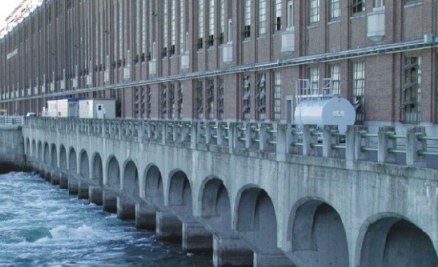
Dam: (
Satellite, actually, the powerhouse is the dam)
RR Bridge: (
Satellite, it looks like a bobtail (offset swing) bridge)
The rapids that this canal bypasses "has a series of rapids, formed by four slope breaks totaling a drop of 25,6 [84'] meters over 12,8 kilometers [8 miles]." [
CanalDeSoulanges] So each lock probably has a lift of 42' (12.8m).
 |
stlawrencepiks, this has more maps and construction photos of the locks
"This map illustrates three sets of canals that were built in this area between Lake St. Francis and Lake St. Louis. The old Beauharnois Canal that ran from Valleyfield to Melocheville, (not shown), the Soulanges Canal that bypassed the rapids by going north of the river and the Beauharnois Power and Seaway Canal." |
The canal is on the right side of this photo.
Note the suspension bridge on the right.
After heading north from the bridges over the tailrace of the powerhouse, one comes to the tunnel under the Seaway canal. It looks like they moved more rock in the cuts to the approaches than from the tunnel itself.
In the foreground is the railroad drawbridge and Lock #2. I looked at every street view available, and the upper rail hid Lock #1 and the top of the powerhouse in each one.
This satellite image allowed me to identify the railroad drawbridge as a bobtail bridge. But what makes this particularly noteworthy is that one of the miter gates has been augmented by sector gates. I've seen sector gates before in rather low-lift locks, but this lock has a rather high lift. Judging from some of the photos, they normally use the miter gates.
 |
HydroQuebec_history
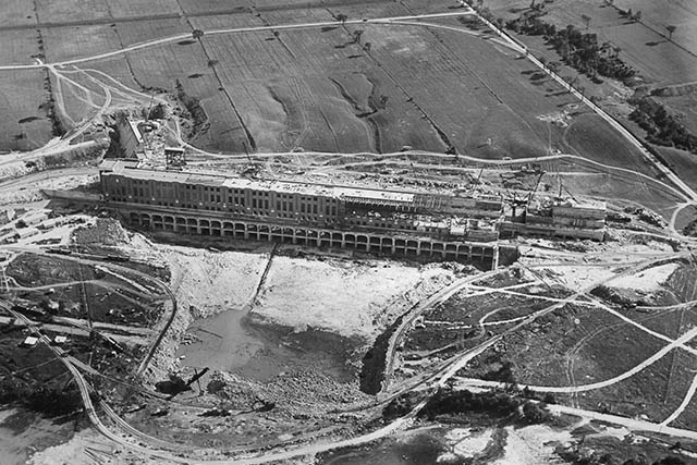
The plant was built in three phases. The first phase was completed in 1932 and included the headrace canal and 14 generating units. The second phase finished in 1951 and added 12 units. The third phase added 10 units by 1961
The plant is 926m (0.58 miles) long. |
 |
Milieu
"The Beauharnois Power Station is capable of generating 1,911 MW at a maximum flow of 8,200 m3/s.[1m3 = 35.3cu.ft. so the flow is 290kcfs. (Can fill 3 Olympic-sized pools every second.)]...There are 36 turbines in total, 26 of which are Francis Turbines and a further 10 conventional blade [Kaplan] turbines....The Beauharnois canal brings water from Lake Saint-Francis to the dam. It is 24,5 km [15 miles] long by approximately 1 km [0.6 mile] wide for a maximum depth of 9m [30m]. In front of the dam the depth can reach 20m." |
That flow is just a fraction of the river's flow. There is another hydroelectric plant in the river itself.
The draft of ships using the
St. Lawrence Seaway is 8m (26') [
Dennis DeBruler], so the 9m depth of the headrace canal could handle the Salties. Thus the Seaway construction simply had to add a couple of locks on the west side of the headrace.
Looking Southish or upstream:
Looking Northish or upstream:
.jpg) |
Michael Restoule posted
Ecosse ,Miss MJ and Vigilant 1 in the upper and lower Beauharnois locks Quebec |
 |
Skye Media Quebec posted
Did you know that? Beauharnois locks have 2 layers of water. The first level at Lock 3 is open to the public, but the second level, even later, is not. Here is a unique view of Lock 4 that goes under the Madeleine Parent Bridge of Highway 30 and gives access to the Beauharnois Canal. It takes about 1 hour per platform to raise the 2 levels of water for the ships. [This was auto translated from French.] |
Jan 5, 2026:
Janey Anderson
posted four photos with the comment:
Upbound Traffic Resumes at Beauharnois After Prolonged Delay
After several days of delays caused by heavy ice and one-way downbound traffic, upbound movement has finally resumed at the Beauharnois Locks.
Tanker Algonova was first to make the passage, now en route to Sarnia. Following closely behind, tug Wilf Seymour and barge Alouette Spirit also underway, heading upbound to Hamilton.
With freezing conditions causing repeated issues in the lock chambers and requiring slow, staggered transits for downbound vessels, this progress marks a significant shift in momentum.
Here you see Wilf Seymour pushing Alouette Spirit barge shots in the icy lock and following Algonova and CCGS Des Groseilliers upon exiting.
Jan. 5, 2026
Anthony BK: That was me in one of the excavators since dec 25th on the left ! Top and bottom lol
 |
| 1 |
 |
| 2 |
 |
| 3 |
 |
| 4 |


.jpg)


