Showing posts with label rrPanhandle. Show all posts

Thursday, May 28, 2026

Pennsy Bridge over B&O in Indianapolis, IN

(Satellite)

I don't normally note railroad overpasses, but the comments on this post provide a lot of information about the B&O branch

Satolli Glassmeyer posted
Need  some  help...
I’m  doing  research  on  a  CSX  single  span  through  truss  bridge  west  of  Indianapolis  that  spans  the  former  B & O  Rail  line:  GPS  Coordinates:  39°47'40.4"N 86°18'18.7"W.  Does  anyone  know  when  that  section  of  the  B & O was  closed  and  does  anyone  know  where  I  can  find  pictures/video  of  trains  on  that  section  of  B & O rail  line  or  of  trains  crossing  the  CSX  bridge  above?
AJ Clapp: Here is video from I believe the section foreman taken from the caboose of one of the last revenue trains. West out of Indy to I think somewhere west of Marshall, In

1959/61 Clermont Quad @ 24,000

1958

Comments on Satolli's post

Is this the Pennsy overpass?
6:38 Bluejacket01 video @ 2:00
Caboose Ride on the Decatur Sub


Thursday, May 29, 2025

Busway/Pennsy/Panhandle and Corliss Tunnels in Pittsburgh, PA

Panhandle West Portal: (Satellite)
Panhandle East Portal: (Satellite)
Road: (Satellite)

It you see a photo of a tunnel portal and you can see the other end, then it is a portal of the road bridge because that tunnel is short, straight and wide. I focussed on the Panhandle tunnel.

HistoricPittsburgh, cropped
May 22, 1914
"Workers gather under Pittsburgh, Cincinnati, Chicago & St. Louis Railroad tracks during excavation of the Corliss Tunnel. The Pittsburgh, Cincinnati, Chicago & St. Louis Railroad, formed in 1890, is a branch of the Pennsylvania Railroad Company."

HistoricPittsburgh
May 22, 1914
"Three workers watch the photographer as one man sits on a wagon labeled M. O'Herron Co. and two others stand on a steam shovel in this view of excavation on the sub-grade at the south end of the Corliss Tunnel."

pitt
May 22, 1914
"Freight trains sit at the slip of the railroad embankment at the south end of the tunnel on Corliss Street. Men can be seen repairing the tracks, while houses are visible on the hill in the background."

This tunnel was west of Corliss Yard.
1951/51 Pittsburgh West Quad @ 24,000 via Dennis DeBruler


Friday, January 5, 2024

Aban/Pennsy (Panhandle) 16th Street Yard

(Satellite, the elevated tracks have been replaced by elevated trees.)

The train is passing through the Western Avenue Junction.
Lake States Railway Historical Association posted
B&O 59 with passenger train 7, The Shenandoah at Western Avenue Junction in Chicago, IL October 1947. Robert Milner photo.
If you enjoy the photos and what Lake States is accomplishing, consider joining Lake States or making a donation, or both: https://www.lsrha.org/?page_id=135
Lake States Railway Historical Association shared

Dennis DeBruler commented on the above share
So that curved connection used to have more than one track. And the Western Avenue corridor used to have a small yard instead of trees on its west side. 
 I've seen a few photos of trains on this connection leaving Grand Central Station. But this is the first one I have seen of a train heading to the station.
 https://www.google.com/maps/@41.8630471,-87.6874273,204m/data=!3m1!1e3?entry=ttu
Bob Lalich: Dennis DeBruler - the yard in the background was PRR's 16th St Yard. It was used for servicing the local industries and for interchange with Soo Line and CGW.

Dennis DeBruler commented on Bob's comment
Thanks. I had forgotten that the Pennsy panhandle used that route to access the north side of Union Station. And I've never seen a name for that yard before. That area certainly used to have a lot of industry.
1953 Englewood Quad @ 24,000


Monday, January 3, 2022

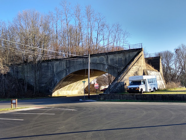
1910-1983 Aban/Pennsy Concrete Arch Overpasses in Cambridge City, IN

Foote Street: (Bridge HunterSatellite)
Center Street: (Bridge Hunter; Satellite)

I normally don't note overpass bridges unless they are over an Interstate with lots of lanes. But I can't remember seeing a concrete arch used for an overpass.

Street View

Bryan Monaco posted
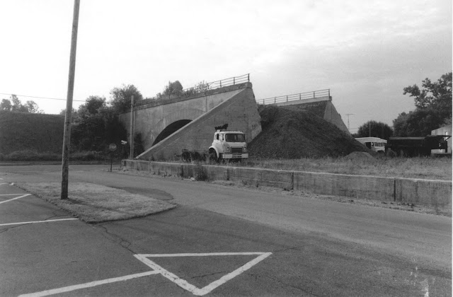
The Pennsylvania Railroad once crossed over Foote St., in Cambridge City, Indiana. This line was abandoned in 1983.
Matthew Lappin: They tore this down in early 2000s as it literally cut this town in half.
Phillip A. Finnerty: I have seen on the Google map and looked at it on street level, that the former Pennsylvania railroad line from Richmond Indiana, to Indianapolis Indiana was elevated in 4 different locations that I have seen so far, it was elevated in cambridge city, Lewisville Indiana, raysville Indiana and knightstown Indiana. There might be other locations.
Phillip A. Finnerty: I heard from some one that they had a hard time back then taking other bridges down in cambridge city Indiana and just gave up and left the other bridges on Foote street and another street east of foote street alone.
Ethan McDowell: Cambridge City used to be all concrete arch. Over the decades it was torn down to make more room to grow.
The PRR was at least double tracked along most of its route.
Mark Backhaus: This was an earth filled bridge. The fill inside the bridge was probably partially removed when the fill was removed beyond the bridge to prevent it from collapsing off the end of the bridge.

Tim Shanahan shared
Bruce Bridges: This picture gives you a very good idea of how these concrete arches are put together! It's basically a one piece poured structure with the dirt built up around it.

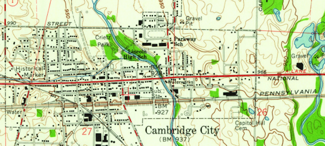
Looking at a topo map, it becomes clear that Pennsy elevated their tracks through town to reduce the size of the cuts needed through the hill west of Walnut St. and the hill between the two river valleys on the east side of town.
1960 Cambridge City Quadrangle @ 1:24,000

I haven't seen concrete overpasses because I don't live in the right area. I'm reminded that Pennsy liked arch bridges. They started with masonry bridges. For example, the Rockville Bridge. Given that culture, it is not surprising that most Pennsy overpasses in this city were built with a concrete arch. (Meredith Street may have used steel girders.)

The builder of these overpasses in Cambridge City, P.F. Brendlinger, was evidently using precast segments rather than casting-in-place. The wood structure in the photo below is not forms for reinforced concrete, but falsework to hold the segments in place until the arch is complete. So Brendlinger was using masonry techniques with "big stones" made with concrete.
Digitized by Google, p136 via BridgeHunter-Center

You can still clearly see the segments used to build the arch.
Street View

Mark's comment about the arches being earth filled and this photo explains what we see today.
Indiana State Department of Natural Resource, Division of Historic Preservation and Archaeology via BridgeHunter-Foote

This view better shows the retaining wall that they added so that they could remove the remaining embankment dirt.
Street View

So it is now rather obvious that the city removed the overpasses from Walnut, Jones and Green Streets, but that they gave up when they got to Foote Street except for Plum Street. That arch was narrow enough that they did remove it.
Street View

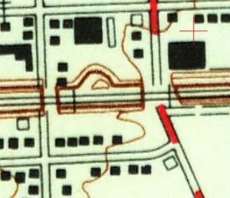
Since the arches were built with "big stones" instead of reinforced concrete, they should not have been that hard to take down. So why did they stop at Foote Street? The topo map helps answer that question as well. The depot was obviously built on an embankment just east of Foote Street.
1960 Cambridge City Quadrangle @ 1:24,000

In fact, parts of the retaining wall used to construct the depot's embankment are still peaking through the vegetation. Look in the upper-right corner of this excerpt.
Satellite

This photo is what motivated me to look for the depot's location.
Photo by Jim Grey via BridgeHunter-Foote


Tuesday, June 9, 2020

WSRY, KR and CERA Railroads

The alphabet soup in the title is Winmac Southern Railway (WSRY), Kokomo Railroad (KR) and Central Railroad Company of Indianapolis (CERA).

These shortlines are another example of how important rail service is for a grain elevator. We already have seen that the owners of the South Milford grain elevator bought the Wabash route between their elevator and Montpelier, OH, and they work with Indiana Northeastern to operate it. And Alliance Grain helped form the Bloomer Line from remnants of IC and Wabash to provide rail service to its various grain elevators.

Below is a capture of a Kokomo Grain web page with their Locations menu displayed.
Kokomo Grain
I started laboriously plotting where these Kokomo Grain locations were on a map. Fortunately, I soon discovered that Google Map would do the work for me. The marker in the upper-left corner in the map below is Amboy and the lower-left is Burlington. The one above Converse is Amboy. I added lines to stylistically (i.e. not accurately) represent the historical railroad segments. There is a map in Logansport Hub that accurately plots how the railroads passed through Logansport.
When these segments were abandoned by the Class I railroads, the blue lines became WSRY, the red line became part of CERA and the yellow line became KR. Kokomo Grain had partial or total ownership of these new shortlines.
Satellite

Every attempt I have made to explain the ownership/operation details of WSRY ended up as a disappointing draft. Fortunately, James Nobbe commented on a post:
Originally, WSRY looked like an upside down Y with 3 lines radiating out of Logansport to Winamac, Bringhurst, and Kokomo. All ex PRR. Was jointly owned by Kokomo Grain and Frick Services and operated under lease by CERA (which pre Railtex belonged to Kokomo Grain along with the CIND). Joint ownership ended and Frick kept Logansport to Winamac and Kokomo the other two legs and ultimately sold the CERA to Railtex. Frink later sells his portion to TP&W who later abandoned.. Exit Railtex, enter RailAmerica. Relationship between Kokomo and RailAmerica hits the skids and Kokomo replaces CERA with USRP as designated operator of the WSRY, Unfortunately, RailAmeirica figured out that the way the Kokomo/Frink split was worded (or lack of wording) that TPW could clam ownership of the WSRY mainline from 18th St yard to Van Jct as part of the Frick conveyed property, Legal battle ensues and RA wins, splitting WSRY into two pieces. TIme and more level head management at G&W heals wounds and Kokomo now on good terms with G&W. USRP lease is up, and has been problematic, so it was not renewed and new lease given to G&W who will operate as part of TP&W. The C&O piece from Marion to Amboy is Kokomo Rail, also owned by Kokomo Grain, It's one and only customer is Kokomo Grain Amboy, who does nothing but unit trains. NS power stays with unit train. Kokomo Rail would "rent" a crew from USRP to move the trains as needed. Assume they will now rent a G&W crew. Kokomo Grain also owns ex PRR from Anderson to Fowler IN and operates it as the Indian Creek Railroad. They continue to operate that themselves.
Additional comments on that post explain how the namesake of WSRY, Winmac, no longer has rail service.

When G&W assumed ownership of TP&W and CERA, the management style changed from greed and/or ego to logic so TP&W operates the remaining southern segments of WSRY and CERA operates the KR segment. [ProgressiveRailroading]
CERA
It is worth noting that Central of Indianapolis does not touch Indianapolis, but Central of Indiana (CIND) does.

Also note that the Panhandle Segment now controlled by TP&W connects TP&W to CERA. And the west end of TP&W connects to TZPR, which connects to IMRR. So G&W now owns about 400 contiguous miles in Indiana and Illinois.

I wonder what motivated these 2012 plans to reopen the former NKP Lake Erie & Western segment between Kokomo and Tipton, IN. I don't think this plan has been implemented. [KokomoTribune]


Tuesday, January 28, 2020

BNSF/CB&Q crossing over Aban/Panhandle+B&OCT+NS/NYC/CJ

(Satellite)

This crossing is unusual because it has two connections in the southwest quadrant. It is also unusual because most of the tracks that were in the crossing in 1938 are still here. The notable exception is the Pennsy Panhandle tracks that used to be on the west side of the Western Avenue Corridor.

Satellite
A regular connection used to connect the CB&Q with Pennsy's Panhandle.
Satellite
A track has been added to crossover the former Panhandle RoW and connect to the B&OCT tracks. There is also a track going south that is part of BNSF's Horseshoe Project.
3D Satellite
A flyover connection still connects the BNSF mainline to a BNSF branch that heads south to a few remaining industries along the South Branch of the Chicago River. And a regular southeast connection still connects that southern branch to the other direction of the BNSF mainline.


Getting photos of the "bridge" that provides a pier for the flyover when it crosses the tracks was an agenda item of a field trip. I got photos from several vantage points starting with a view of the east side of the "bridge."
20180812 3489
While still on the east side of the CB&Q branch, I got some views a couple of blocks south of the "bridge."


Working my way further south.
Now I'm taking photos on the west side of the tracks in the Western Avenue corridor.

This is a reminder that steel is strong in tension. That is why the center member that holds up the west girders of the flyover can be so small.
[Now I wish I had taken a step or two to the left before I snapped this photo. Maybe my unconscious mind was trying to get all of the graffiti.]

This was a deliberate attempt to incorporate the two water towers and the smokestack that I took photos of on the east of the connections.

I also grabbed some shots of the crossing from a commuter train.
20170421 8696
You can see the regular connection on the right and the beginning of the flyover connection in the foreground. In the middle background is the "aerial pier." (The green hue is because the windows on the train are tinted green.)


Wednesday, January 22, 2020

UP/C&NW Rockwell Junction (Wye)

(Satellite)

(Update: the west end of the wye is controlled by Kedzie Tower.)

John Morris posted
[There is much more info on this posting below. To summarize that information, this is looking south at a compass northbound (timecard westbound) train that has taken the west leg of the Rockwell Junction Wye.]
On a contemporary satellite image it is easy to see the two legs of the wye because all of the other tracks have been removed.
Satellite
For decades Pennsy's Panhandle had tracks next to the east leg. Multiple sources think the tracks that used to be inside the wye were a yard for the Panhandle. Other sources think the tracks were C&NW's South Yard. The tracks that still exist above the mainline were the North Yard. My conclusion is that the west track on the east leg was owned by C&NW and that the land now used by Sims Metal Management was C&NW's South Yard. In fact, Bob Lalich identifies the yard as a C&NW freight yard.

In fact, this C&NW freight yard was the interchange with Pennsy. [Position-Light, Part 1, source]
Metra via Position-Litght, Part 2 and a Tower A2 Album
[This confirms the yard and the west track of the east leg was C&NW.]

I include the CTA's Green Line at the bottom because that is the truss bridge in John's photo.
1929 Chicago Loop Quadrangle @ 1:24,000
This photo copied from the C&NW Passenger Yards notes
WW2 Radio post, #28
Timothy Pitzen David Daruszka, if I remember correctly, the yard to the right, or south, of the C&NW main was the Pennsy coach yard. Also, the haze may be exaggerated by the old style film which was more sensitive to blue wavelengths which tends to accentuate haze.
Dennis DeBruler I always wondered where the Panhandle yards were.
David Daruszka The Sanborn maps show Panhandle freight yards as being in the area between the Rockwell Jct. wye. There were also yards closer to downtown adjacent to the Milwaukee Road tracks. The Panhandle had a freight house at Sangamon Street.
Bob Lalich The yard south of the CNW main tracks was a CNW freight yard.
Another aerial photo that includes the junction.
29
David Daruszka C&NW California Ave. Coach Yard. Milwaukee Road tracks and yard to the left. C&NW's Rockwell Branch is above the Coach Yard.
Harvey Kahler Both Rockwell and Panhandle (PCCC&StL) head off top right (south).
David Daruszka This was also the route, for a brief time, for the B&O passenger trains when they left Grand Central and moved to the C&NW's Madison Street Terminal.

I include the information on the post in a raw form because it is an example of a positive use of social media. As someone said, the bee hive is smarter than any bee. Note that not only was the location of the photo determined, but the train itself and the now removed Pennsy Panhandle tracks were discussed. Below the Facebook screenshots are higher resolution copies of the images.

1

2

3

4

5

6

David

Bob

Dennis

Dennis

Bob

Dennis

Patrick

Dennis

Bob