Showing posts with label wwNortheast. Show all posts

Tuesday, September 16, 2025

1955,2008 Roosevelt (Welfare) Island Bridge over East River in New York, NY

(Archived Bridge HunterBridge Hunter; Historic Bridges; Satellite)

Boat View, Nov 2016

HistoricBridges
The 958' (292m) long bridge has a main span of 418' (127m).
"This vertical lift bridge provides the only direct vehicular access to Roosevelt Island. The bridge does not operate for boats very often, reportedly most openings occur during the United Nations General Assembly when the west channel of the East River is closed to marine traffic for security. The bridge cost $6,498,255.13 to build, and opened May 18, 1955."
[I wondered why boats would use the east channel.]

This shows why the length of the bridge is over twice that of the main span. It has a viaduct over industry on the east side. Consequently, the span has significant clearance when closed.
2008 photo by Michael Minn (michaelminn.com) via BridgeHunter

2021 photo from the Queensboro Bridge by Geoff Hubbs via BridgeHunter


Wednesday, February 26, 2025

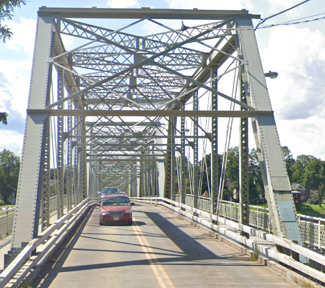
1805+1909,1985 US-4 Waterford (Union) Bridge over Hudson River at Troy, NY

(Bridge Hunter; Historic Bridges; Satellite)

Street View, Aug 2023

Postcard via Historic Bridges
"This is a rare surviving example of a urban pin-connected truss bridge over a major river....This bridge sits at the site of the first bridge over the Hudson River."
The 743' (227m) long bridge has a main span of 200' (61m).

Waterford is where the Erie Canal joins the Hudson River.

Photo taken by Jag9889 in 2009 via BridgeHunter

It makes sense that the first bridge was a covered bridge.
Postcard via BridgeHunter

Photo taken by Richard Doody 1990 via BridgeHunter

1 of 4 photos posted by East Coast Roads
New page for US 4 in New York.
East Coast Roads shared

Thursday, December 19, 2024

I-78 Holland Tunnel under Hudson River at New York, NY

West Portal: (Satellite)
Ventilation Shaft #1: (Satellite)
Ventilation Shaft #2: (Satellite)
East Portal Eastbound: (Satellite)
East Portal Westbound: (Satellite)

The History Girl posted, at Facebook resolution
October 12, 1920, construction began on the Holland Tunnel. The tunnel is one of the earliest examples of a mechanically ventilated design with 84 fans in four ventilation buildings which create a floor to ceiling air flow across the roadway at regular intervals. The tunnel consists of a pair of tubes, each providing two lanes. The north tube is 8,558 feet long while the south tube is slightly shorter at 8,371 feet. The tunnel was named after chief engineer Clifford M. Holland, the first chief engineer on the Hudson River Vehicular Tunnel Project. He died from a heart attack at age 41 (before the tunnel was completed), attributed in part to the stress of working on the tunnel.

Old New York City posted
Holland Tunnel 1937
Jim Griffin: "Cars at state line in Lincoln Tunnel. (Photo by Al Willard/NY Daily News Archive via Getty Images). On December 22nd, 1937, the Lincoln Tunnel opened to the public for the first time." [No one else felt the photo was of the Lincoln Tunnel instead of the Holland Tunnel.]

When I first wrote these notes, I could not find the east portal. But when I was studying the NYC St. John's Freight Terminal, a topo map showed me the location of the portal.
1955/58 Jersey City Quad @ 24,000

Friday, December 13, 2024

1883+1905 NYC Wilbur Bridge over Rondout Creek at Kingston, NY

(Bridge Hunter; Historic Bridges; B&T; 3D Satellite)

It was built by the New York, West Shore & Buffalow Railroad (NYWS&B).

2011 Flickr Photo taken by Joseph via BridgeHunter, License: Creative Commons Attribution-NonCommercial-ShareAlike (CC BY-NC-SA)
Rondout Railroad Bridge
This impressively high bridge spans the Rondout Creek in Kingston, New York. CSX freight trains still frequent it heavily.

I include this view from the Wurts Street Bridge because I was studying that suspension bridge and noticed this bridge.
Street View, Oct 2019

In fact, the Wurts Street Bridge appears in the left background of this photo.
1 of 3 photos posted by Bridge & Tunnels
The Wilbur Bridge is a testament to the undervalued significance of railroad bridges within transportation infrastructure. Despite its lack of ostentation, the bridge has a rich history dating back to its construction in 1882-1883 by the New York, West Shore & Buffalo Railway. It was initially built with three Whipple through trusses and a towering height above Rondout Creek. The line was later reorganized as the West Shore Railroad by the New York Central in 1885, leading to plans for a new viaduct to accommodate increased weight in 1901.
The replacement of the Wilbur Bridge was carried out seamlessly, with no disruption to freight or passenger lines. The American Bridge Company was responsible for its construction between 1904-1905, utilizing a main Parker through truss span and a deck truss, among other configurations. One of the original spans from 1883 was repurposed for the Mahopac Branch of the New York & Harlem Railroad, while another was dismantled and relocated downstream.
➤ Check out more photos of this impressive bridge at 
Dennis DeBruler: I like that you included the Wurts Street Bridge in the background.

B&T
The steel towers are 155' [47m] tall and the total height was 195' [60m].
HistoricBridges

Dave Blaze Rail Photography posted
M218 On High
I shared a couple of track level head on shots from earlier this same day but then returned after a sojourn to the east side of the river to capture this view from below. 
I'm standing along the north bank of Rondout Creek off of Abeel Street upstream of the railroad looking up at the 1228 foot [374m] long Wilbur bridge standing some 198 feet [60m] above water level.  CSXT train M218 (Selkirk to Philadelphia East Side Yard unit auto racks) is passing thru the 400 ft [122m] tunnel out of sight at left and sailing high over the creek at MP 87.5 on modern day CSXT’s very busy River Sub mainline. 
To learn more about the history of this spectacular structure and see some historic photos and drawings check out these links: 
CSXT's River Sub (ex Conrail, Penn Central, New York Central, nee West Shore) dates from 1883 in this area and despite being a relative latecomer its mainline up the west bank of the Hudson has only grown in importance over the decades as traffic patterns have shifted.  Today this line between northern New Jersey and the Albany area is by far the busiest north south route in the northeast, while conversely virtually the entirety of the West Shore's route to Buffalo along the south side of the Mohawk River has long been abandoned. 
Kingston, New York
Saturday October 26, 2024

This is obviously during construction of the 1905 bridge.
BridgeHunter

"The main span is listed as pin-connected, but some of the diagonals are rigidly riveted to gusset plates, showing a transition from pin connected to rivet connected thinking. This bridge replaced a very impressive Phoenix column through truss bridge that included "Triple Whipple" (Triple Intersection Pratt) truss spans. One of the approach Whipple (Double Intersection Pratt) spans was relocated and still exists as the Goldens Bridge." [HistoricBridges]

Friday, November 29, 2024

1936 Henry Hudson Bridge over Spuyten Duyvil Creek in New York, NY

(Archived Bridge Hunter; no Historic Bridges; 3D Satellite)

This 1,926' (587m) long bridge has a main span of 800' (244m). [Bridge Hunter]
 
mta
When it opened in 1936, "it was the longest plate girder arch and fixed arch bridge in the world. Originally built with only one level, the bridge's design allowed for the construction of a second level if traffic demands increased. Within a year and a half the upper level was opened. The upper level carries northbound traffic; the lower one is for southbound traffic."

MTA Flickr, License: Creative Commons Attribution (CC BY)
Henry Hudson Bridge Circa 1936
The arch span of the Henry Hudson Bridge, as seen from underneath.
Courtesy of MTA Bridges and Tunnels Special Archives

United States beauty posted two photos with the comment:
The Henry Hudson Bridge is a steel arch toll bridge in New York City that spans the Harlem River, connecting the neighborhoods of Spuyten Duyvil in the Bronx and Inwood in Manhattan. It carries the Henry Hudson Parkway (New York State Route 9A) and has both upper and lower levels, with the upper level accommodating northbound traffic and the lower level handling southbound vehicles. The bridge was completed in 1936 and was designed by David B. Steinman, featuring a central steel arch with a span of 840 feet, which was the longest of its kind when it opened.
Operated by the Metropolitan Transportation Authority (MTA), the bridge was originally built as part of Robert Moses’s extensive parkway system and was intended to enhance access to New York’s parks and suburbs. Today, it is an essential connector between Manhattan and the Bronx, with scenic views of the Hudson River and surrounding landscapes. The Henry Hudson Bridge has undergone various renovations over the decades, including updates to its tolling system, which now uses electronic tolling to facilitate traffic flow and reduce congestion. The bridge’s location and design make it a notable part of New York’s infrastructure, balancing functionality with aesthetic appeal.
1

2

Jeffrey Gluck posted
Henry Hudson Parkway Bridge (NY Route 9A)
Spiro Polychronopoulos: Jeffrey Gluck absolutely love the height on this one!!!
Jeffrey Gluck: Spiro Polychronopoulos Supposedly they’ve been a few suicides off the bridge. It is pretty high.
 
OnFootOnWheels
"At mid-span the lower level of the bridge is 135 feet above mean high water."
[This would be a photo of the Amtrak/NYC Bridge taken from the Henry Hudson Bridge.]

Rob Rubino posted
New York Central Railroad electric locomotive no. 226 leads eastbound passenger train no. 8, the "Wolverine," in the Spuyten Duyvil neighborhood in New York, New York, on December 1, 1967. Photograph by Victor Hand.
Steven Magnotti: 6 more days after this shot was taken would be the last run of the Century.
Joseph Buchalter: That is southbound. The palisades are in the background, Spuyten Duyvil creek is on the left. That spot is just below my building on top of the hill to the right. It was built that year and is out of the line of sight. actually eastbound, then southbound into Grand Central.
Tom Leigh: Joseph Buchalter many US railroads used "east" and "west" as general operating directions. Found this chatty link:
Edward Kwiatkowski shared
Steven Goin: I didn't realize those units were used on passenger trains. For some reason, I thought they were only used on the approaches to stations.
Jonathan Dandridge: Steven Goin they were used between Grand Central and Croton Harmon where they were swapped out for Diesels. I remember seeing them at GCT in the late 60s. Shortly thereafter when PC took over they brought in ex NH FL-9s dual modes and retired the electrics.
Bernie Bierman: Jonathan Dandridge But not before they had New York Central diesel E units entered the Park Avenue tunnel (because of the "deferred maintenance" policy applied to both T-motors and P-motors), almost asphyxiating both long-distance and commuter passengers. This was clearly the nadir of the PC, which actually faced a revolution by the normally staid commuters. It was after the service was handed over to Conrail that the old NH FL9's started to show up on the Hudson and Harlem Divisions.

Google search results, I could not find an attribution
[The Amtrak/NYC Bridge is in the foreground.]

In the south approach, there used to be a lot of columns in the lower (southbound) roadway to support the upper (northbound) roadway.
Street View, May 2011

$90m dollars was spent to remove those columns and redo the toll booths. [entech], 
Street View, Jun 2024

streetsblog, Screenshot via Google
In 2025, MTA plans to finish a $20m project to replace the sidewalk with an 8' (2.4m) wide structure so that bikers can legally ride their bike across the bridge. (They are now supposed to walk them.)


Saturday, November 9, 2024

NYNH&H Bridge over North River in Marshfield, MA

(Archived Bridge Hunter; Satellite)

NYNH&H = New York, New Haven & Hartford

Douglas Butler posted on Nov 14, 2022
From books.google.com NH Railroad Strauss Overhead Counterweight Bascule Bridge is removed in Marshfield, MA crossing the North River.

Douglas Butler posted
Source of Railway Gazette: NYNH&H RR Strauss Overhead Counterweight Trunnion Bascule Bridge in Marshfield, MA crossing the North River was removed.

Friday, November 8, 2024

OOS/HHRC/NYNH&H Bridge over Housatonic River at Derby, CT

(Archived Bridge Hunter; no Historic Bridges; Satellite)

HHRC = Housatonic Railroad
NYNH&H = New York, New Haven & Hartford Railroad

"Built 1904-5; eastern pier collapsed during 1983 flooding, repaired several years later" [BridgeHunter]

Street View, May 2023

Doug Fehmel posted five photos with the comment: "I’m in Derby, CT. There is, what seems to me, an abandoned line from possibly the Housatonic RR. The bridge goes over the Housatonic River."
Steve Mewborn: It seems like they purposely made the bridge span wide enough to accommodate a double-track layout. Or is there another reason why the bridge is much wider and the tracks are shoved to the side?
Kilo Gigawatt: Steve Mewborn As built, it carried twin tracks. Double track operations ended by the early 1960's when NYNH&H completed implementing CTC signaling over the entire line between Maybrook NY and Derby Jct CT. A few sections of the 2nd trackage had been retained for passing sidings and through Danbury CT. Other than the Danbury piece and in Botsford CT, those sidings have also been pulled up.
Brian Burns: Back in the 1980s one of the spans got partially knocked off a pier during a flood. This line was part of the New Haven’s main freight route between New Haven and Maybrook, NY. The line was included in the Danbury Cluster of lines sold by Conrail, to the Housatonic, in the 1990s.
Tim Hession: Garrett Birdsall Used to carry traffic from New Haven harbor to upstate New York via the Poughkeepsie crossing.
Scott Cebelenski: Once a major freight route known as the Maybrook as someone already mentioned. Freight would travel between Cedar Hill Yard in New Haven and access the country over the Poughkeepsie bridge until a fire in 1974 put a stop to dwindling Freight at the time on the bridge. The Poughkeepsie bridge now of course a really fantastic pedestrian crossing over the Hudson.
Ned Roshkind: Sperry uses it for training of track inspection and was used for trap rock new haven to Danbury, current they go down to Norwalk and up, trying to get a clean run to Danbury but government is not helping they
Joey Tichy: I heard that they're rehabbing it and getting it ready for rail traffic once again.
Mark Holden: A developer did build a parking garage for an apartment complex too close to the tracks.
In Shelton, the rules are less important than who your friends are.
Grace Monahan: Mark Holden and it appeared that planning and zoning approved the line overlap onto rail property.
Christopher Jensen: I heard they were possibly looking at reopening it, but now it is a fight with someone. They built the parking garage for the condos apparently to close thinking it was abandoned. Be funny if they reopened it and it pissed those tenants off paying 2-3 thousand a month. Hearing train horns during g the night.
Tim Shanahan shared
1

2

3

4

5

Justin Flickr
Sine here

Thursday, October 31, 2024

1931 Vilas/1840 Tucker Toll Covered/1785 Hale's Bridges over Connecticut River at Bellows Falls, VT

1785 Hale's: (Archived Bridge Hunter)
1840 Tucker Toll Covered: (Archived Bridge Hunter)
1931 Vilas: (Archived Bridge Hunter; no Historic Bridges; Satellite)

This gorge now gets just the water that is not diverted to a canal and powerhouse.

Lost New England posted
The Connecticut River flows for more than 400 miles through New England, and the valley was an important transportation corridor for early European settlers. However, there were no bridges across any part of the river until 1785, when a bridge opened here on this site, connecting Bellows Falls, Vermont and North Walpole, New Hampshire. 
This was an ideal location for a bridge, since the river passes through a narrow gorge with a large rocky outcropping in the middle of the river, making it relatively easy to construct a two-span bridge here. The first bridge was uncovered, which left its deck and structure exposed to the elements, so in 1840 it was replaced by a covered bridge, which is shown in the first photo around 1900. 
Known as the Tucker Toll Bridge, this covered bridge stood here for 90 years, until it was replaced in 1930 by the present concrete arch bridge. However, this bridge has been closed since 2009 because of structural problems, and it is not scheduled to be rebuilt until 2028. Historic image courtesy of the Rockingham Free Public Library.

Keene Public Library Flickr via BridgeHunter_1840
Connecticut River High Water in Bellows Falls Vermont

The stone-arch railroad bridge in the background is also impressive.
Street View, Aug 2013

Photo via BridgeHunter_1931

Thursday, August 1, 2024

1928,2013 Outerbridge Crossing between Staten Island, NY, and Perth Amboy, NJ

(Archived Bridge HunterHistoric Bridges; HAERSatellite, 141 photos)

"Cantilevered through truss bridge over Arthur Kill on NY 440/NJ 440; the bridge was named for Eugenius Harvey Outerbridge, the first chairman of the then–Port of New York Authority." [BridgeHunter]

The bridge is 10,140' (3091m, 2 miles) long with a main span of 750' (229m).
HAER NY,43-____,3--1
OUTERBRIDGE CROSSING BRIDGE IN ELEVATION LOOKING NORTH - Outerbridge Crossing Bridge, Spanning Arthur Kill from New Jersey to Staten Island, Staten Island (subdivision), Richmond County, NY

[Whoops, I forgot to record the Facebook post.]

Michael E Pearson added
Outerbridge Crossing - a 1928 built cantilever toll bridge meant only for traffic, with no transit or pedestrian crossings.
The bridge was named for Eugenius Harvey Outerbridge, the first chairman of what would become Port Authority of NY & NJ. The fact that it's the southernmost bridge out of NYC and the farthest from other NYC bridges, hence an "outer" bridge, is a coincidence. 
If your feet, bicycle or public transit are your only options, and you're coming from Perth Amboy, NJ or points south/west, you either have the Goethals Bridge, the Bayonne Bridge, or the PATH & SI Ferry via Lower Manhattan. Or you can take the really long route and ride the R train into Bay Ridge Brooklyn and hop a bus across the Narrows. You can also take an MTA SIM express bus from Manhattan.

Monday, July 29, 2024

1961 I-295 Throgs Neck Bridge between Queens and Bronx, NY

(Archived Bridge Hunter; no Historic Bridges; Satellite, 866 photos)

The bridge is 12,660' (3.9km, 2.4mi.) long with a main span of 1,800' (549m).

MTA Flickr, License: Creative Commons Attribution (CC BY)
Throgs Neck Bridge Under Construction 1960
View of the Throgs Neck Bridge suspension span under construction, as seen from the Bronx.
Courtesy of MTA Bridges and Tunnels Special Archives

MTA Flickr, License: Creative Commons Attribution (CC BY)
Throgs Neck Bridge 1960
Compressing the cables on the Throgs Neck Bridge. May 24, 1960.
Courtesy of MTA Bridges and Tunnels Special Archives

SfoskettLicense: Creative Commons Attribution-Share-Alike (CC BY-SA)
 
Long Live American Forces posted
The Throgs Neck Bridge is one of the major transportation bridges in New York City, connecting the boroughs of Queens and the Bronx. The Throgs Neck Bridge is tolled for both the ways; toll cost for either side is the same. Both the directions accept only tag transponder or toll by mail; you cannot pay cash on Throgs Neck Bridge.
Beauty of America posted
The Throgs Neck Bridge is one of the major transportation bridges in New York City, connecting the boroughs of Queens and the Bronx. The Throgs Neck Bridge is tolled for both the ways; toll cost for either side is the same. Both the directions accept only tag transponder or toll by mail; you cannot pay cash on Throgs Neck Bridge.
Bridges Now and Then shared
David Cooper: The best reason to go up the Empire State Building is when you go up on a clear night...and count the illuminated suspension bridges all the way to the far horizons.

ColliersEngineering
Identified toxic materials such as asbestos, lead paint and PCBs in caulk materials. Advised as to how to safely deal with those materials during a deck rehabilitation project.
[Why don't web sites provide a date as to when something happened?]

Jeffrey Gluck commented on a Spiro Polychronopoulos post
 
John Powers posted
Throgs Neck Bridge from Fort Schuyler
 
John Powers posted
Throgs Neck Bridge, Bronx/Queens NY

nycroads
This 6-lane bridge uses EZ-Pass for tolls and handles 105,000 vehicles per day. 
Starting in 2005, heavy trucks (over 40 tons) "can cross the span only between 11:00 PM and 5:00 AM at a maximum speed of 30 MPH." This is because they were cracking steel floor beams. The deck had already been replaced in the 1980s because of cracked floor beams.
Between 2000 and 2004, a $23m projected repaired the deck. In 2002, a $10m project rewrapped the main cables and installed a protective islands.

nycroads

Tommy Byrne posted two photos with the comment: "Alot of changes in Beechhurst/Whitestone since 1924.The ThrogsNeck Bridge, Cross Island Pkwy &  Little Bay Park.."
1

2