Wednesday, November 30, 2016

Oil Belt Railway

Ken Pryor Jr. posted two photos with the comment:
The Oil Belt Traction Company, later known as the Oil Belt Railway, based in my home county (Crawford) in Oblong, IL. Incorporated in 1909, this little railroad eventually had 25 mile of track, from Oblong to Bridgeport, IL. They were a poorly run operation that tried to cut corners far too much, resulting in poor performance and derailments. The train became known as the "try-weekly" because it would arrive in Bridgeport and then try all week to get back to Oblong. The OB interchanged with the Illinois Central in Oblong and the B&O Southwestern in Bridgeport. They officially shut down in 1916. Thanks to my friend Terry Ridgley for all the info he's given me on this line.
Not my photos. Dates and photographers unknown.
Richard Mead Lawrence Lore 
Kam Miller That 4-4-0 had to be bought used, too. Not exactly state-of-the-art in 1906.
Ken Pryor Jr. My friend documented in his paper that the locomotive was purchased used from the Illinois Central.


1

2


I figured it had to be abandoned a long time ago because I could find no trace of it on a satellite image. A quick look at an old aerial photo was unproductive also.

I know there is oil around Effingham. I wonder if there used to be oil in this area also because I noticed the town Oil Center is close by.

Update: I'm making spuwho's link hot so that it is easier to access: https://www.frrandp.com/2018/08/the-oil-belt-railway.html

L&N Bridge over Green River near Munfordville, KY

Cliff Downey shared
"Louisville & Nashville RR" 4-8-2 2613 performs a photo run-by at the Green River bridge near Munfordville, KY, on October 24, 1959. The excursion was marking the 100th anniversary of passenger service over the L&N between Louisville, KY, and Nashville, TN. In this view the train is headed southbound.
In reality, the locomotive is IC 2613. The L&N no longer had any serviceable steam locomotives of its own, so it turned to the IC, which still had several dozen serviceable steam locomotives in storage. 2613 was pulled from storage in Centralia, IL, given a quick boiler wash and check up at the Paducah, KY, shops, and then sent east to Louisville. Photo from Chris Thompson collection.
Both Google and Bing had trouble rendering a 3D view. Bing did a little better.

Birds-Eye View

Keith Yearman posted
Louisville-Nashville Railroad Bridge, Munfordville, Kentucky


Is USA loosing another manufacturing capability?

America lost the ability to manufacture consumer electronics in the 20th century.

I've noticed that companies that make heavy manufacturing equipment such as forging presses have been bought out by either Asian or European companies. Typically the American plants are closed because the foreign companies are interested in just the intellectual property such as patents and equipment design. When you see a company announcing a new plant costing over $100million that will create less than 200 jobs, you know it is highly automated. I wonder how much of the equipment installed in that plant was made in the USA. Could the plant be changed to war production if the new equipment would have to be bought from the countries that we have gone to war with?

Now China and other countries are killing America's, and Germany's, steel industry by dumping their steel on the global market.

Ever since reading about the death of our consumer electronics industry, I have been worried about our ability to manufacture semiconductors, especially military grade chips. I worked at Bell Labs and we used to specify military grade instead of consumer grade microcomputers, memory chips, logic chips, etc. for our telephone switching equipment. Military chips can run with colder and hotter temperatures than consumer chips. I remember when I worked at Magnovox and we lost air conditioning in the computer room, the temperature was closely monitored. It finally got warm enough that they had to turn the IBM Model 40 off to make sure it did not get damaged. The room was not hot enough to make you sweat. One would be sweating long before you would have to turn off a Bell Lab's telephone switch. (But by the 1980s, the requirement for military grade chips was being relaxed because we needed bleeding edge designs and they were not available in military grade. Telephone switching offices have a battery plant to run the electronics. Hopefully, they have a diesel-generator set to run the air conditioning.) In a Facebook posting, Steve OConner added comments that indicate my concerns are well founded concerning the viability of our semiconductor industry.
China is dumping counterfeit electronic parts into the Pentagon's supply chain, two senior lawmakers alleged on Monday.Two Senators, John McCain, Republican-Arizona, and Carl Levin, Democrat-Michigan, said the counterfeits are putting U.S. troops at risk and undercutting the American economy.
One day before a Senate Armed Services Committee hearing on the issue, the Senators offered details of the panel's ongoing investigation.....

They found about 1,800 cases of suspect counterfeit electronics being sold to the Pentagon.
The total number of parts in these cases topped one million.
The committee hearing will examine three cases in which suspect counterfeit parts from China were installed in military systems made by Raytheon, L-3 Communications and Boeing.

Levin, the committee chairman, told reporters at a Capitol Hill news conference: 'Now, a million parts is surely a huge number.
'But I want to just repeat this: We've only looked at a portion of the defense supply chain. So those 1,800 cases are just the tip of the iceberg.'
The investigators found that counterfeit or suspect electronic parts were installed or delivered to the military for several weapons systems.
They include military aircraft such as the Air Force's C-17 and the Marine Corps' CH-46 helicopter, as well as the Army's Theatre High-Altitude Area Defence (THAAD) missile defense system....

Investigators traced more than 70 per cent of the cases to China.
Nearly 20 per cent led to the United Kingdom and Canada, the lawmakers said.


“Early in the Iraq war, for instance, stocks of precision bombs were so reduced that the Pentagon ordered Boeing to ramp up emergency production. Boeing’s attempts to supply the military’s needs were thwarted by a Swiss company, Micro Crystal, which—angered by the U.S. decision to invade Iraq—ceased delivery of a key part, according to defense officials. Because no firm in the U.S. made the part, finding an American company capable of starting a new production line took the Pentagon seven months. If the most powerful military in the world could run short of a key weapon system against a third-rate military power like Iraq, what would happen if we faced a more powerful opponent such as China?”
In short, USA has lost most of its manufacturing capability that we had when we geared up for WWII production. Perhaps it won't matter because the next war might be a cyber and satellite war instead of a bang-bang, boom-boom war. But even a cyber and satellite war needs a semiconductor industry.

Chicago lost its movie making industry to Los Angeles, but at least that stayed in USA.

Chicago was the candy capital of the world until a sugar tariff caused many of the manufactures to leave the country. So in the end, the tariff did not protect the jobs of sugar producers, it also destroyed the jobs of workers in companies that used sugar.. But at least we still have Bloomers Chocolate so we should be able to make war rations.

Root Street Tower: Rock Island and NYC access to stockyards (Chicago Junction)

(Satellite)
NorthAmericanInterlockings:  photo photo photo photo
Chicago and Northern Indiana Railroad Interlocking Towers (click the marker for more information)

This tower controls access to the route that goes west from here. That route used to be how the Rock and NYC accessed the stockyards. They probably also turned their passenger trains using the wye with the Chicago Junction. This tower also controlled entry to their Root Street Yards

Mark Hinsdale posted
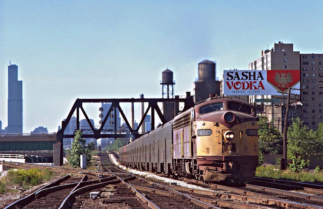
Just a few miles out of Chicago's La Salle Street Station, Rock Island's 5:16 PM Main Line to Joliet" Express blasts out of the hole under the Chicago Junction Railway bridge (long gone), past notorious public housing projects (long gone), beneath steam era signal installations (long gone) and past Root Street Tower (inactive but still standing), in July, 1977.
Update:
Mark Hinsdale posted
"Rush Hour Rock(in')"
On a hot and hazy July, 1977 afternoon, a westbound Rock Island commuter train, made up with a string of the railroad's #2700 series Pullman-Standard double door coaches, dips under the Chicago Junction Railroad (CJ) bridge near Root Street on Chicago's South Side. The wye tracks curving to the left formed a connection between the Rock Island main line at 47th Street and the CJ, and was regularly used by freight transfers back and forth between Rock Island's Burr Oak Yard in Blue Island and CJ's Ashland Avenue facility. Does anybody remember "Sasha Vodka?" July, 1977 photo by Mark Hinsdale
Ron Wesolowski: And this tells the story of the left handed running... train on Mainline 4 signal outbound only... 3 to the right was taken OOS. probably not long after these pictures.... 5 to left was bidirectional signals so it became the inbound track.
Mark Hinsdale shared
Richard Haave: Transfers went beyond CJ's Ashland Ave yard to the Chicago Produce Terminal at Ash St. and CNW's potato yard at Wood St.

Street View
Joe Usselman posted two photos with the comment: "Root street tower showing some of its heritage in 2015."
Zachary C. Gillihanhttp://www.rrsignalpix.com/tower_rootstreet.php
Lawrence Smith this was the tower that routed the NYC passenger consists to and from LaSalle St station into Root St yard - the passenger yard for NYC in CHI. The yard is vacant land now. i think the Chicago Junction wye was there too. Think the NYC (and maybe the RI) turned their trains on that wye. Needs to e confirmed.
1

2
William Shapotkin posted some photos of the CJ's connection with the IC. Several comments were about this CJ connection with RI+NYC.
Ron Hull The NYC passenger car yard and commissary were located immediately south of Root St tower. The tower controlled movements in and out of the north end of the yard. There was also a north and south Y controlled by Root St, enabling movements from the joint RI/NYC line to the CJ. In Penn-Central days, we delivered most of the SV piggyback trains from the east to the CJ at Ashland Ave, then came back to Englewood with the engines and caboose - “cabin light.”
Rod Truszkowski Some of that right of way still exists over the Dan Ryan expressway at root street
William commented on his posting
Yes it does. And (from what a understand) is still used -- mainly for CRL movements from/to Ashland Ave Yard and for Metra equipment moves. Recently obtained (from a friend, Bruce Moffat) a pic of the CJ undercrossing of the PRR (PFtW&C)/C&WI at 40th St -- just a few blocks west of the Dan Ryan. The Stock Yards 'L' is DIRECTLY above the CJ at this point. View looks east in this pre-1958 photo.
Ean Kahn-Treras the only thing it should be used for is the occasional Metra MOW move. I've caught a switcher with a crane on a work train buried back in there on the CJ just east of the PRR/CWI overpass.

It sure isn't too often that they get over here.
David Daruszka I think the inactive tower is still there at Root Street, used by the MOW Department.
William commented on his posting
You are correct, David Daruszka -- Root St Tower (on the ROCK) still stands, albeit no longer an active tower. Here is a pic, taken by the late Don Davis (a long-time ROCK (and later METRA) employee) looking E-N/E. (Understand the housing project in background is now gone.)
William commented on his posting
And an interior photo -- also taken by Don Davis:
Ron Roma commented on William's posting
Here's a shot I took at Root Street in 2010 (after the tower had closed), taken with permission. The CTC panel at right controlled trackage as far south as 51st Street.

This shows how the Rock Island yard was removed to make room for the Dan Ryan and the wye for Root Street Junction. It also shows the CHA projects of Stateway Gardens and Robert Taylor Homes.
Lynette Wilson Sharp posted
1960s
Looking South:
Michael Brandt posted
Clearing out land for construction of the Dan Ryan expressway, from 1960.

A satellite view to confirm the location of the above aerial photo.
Satellite


A posting asking about tracks east of this tower that used to connect the Illinois Central to the Union Stock Yards has a lot of interesting comments.

Mark Vogel Flickr Album

D.W.Davidson Flickr Photo  (Some of the high-rise "projects housing" buildings are in the background.)

27:53 video

Tuesday, November 29, 2016

1917 Hell Gate Bridge

(Bridge HunterHistoric BridgesDave Frieder PhotosSatellite, 1700 photos)

(Update: Fred Hadley posted a history, photo and drone video.)
Albert R Brecken posted
Section of the Hell Gate Bridge that spanned the Easr River as viewed without the massive "portal" towers at each end of the span.

John Powers posted, cropped
Hell Gate Bridge, NY
[With the RFK Bridge in the background.]

Arch bridges push out as well as down on their abutments. I always assumed the portal towers provided mass to help resist the outwards forces. But this indicates that they are just decorative. The bridge was completed in 1916 when railroads could afford to spend money on decoration. I then assumed that this must be one of the places in New York where the bedrock is at the surface so they could easily anchor the bridge to bedrock. But then I learned that caissons had to be sunk 90 feet to reach bedrock. [nycroads] I wonder how much of the expense for building to decorative portals was used to build foundations for all of that masonry.

nyc-architecture

Jeffrey Gluck posted
Hell Gate Bridge (NY Connecting Railroad)—Formally designated (on the dedication plaque) as the "East River Arch Bridge"

 Historic Bridges
In fact, the bearing is mounted to the base at almost a 45-degree angle indicating the arch does push out about as much as the weight of the arch pushes down.

It was the longest steel-arch bridge in the world when built, and it "was named after the narrow channel of strong waters and dangerous rocks in the East River running underneath the structure (known as Hell Gate)." [parachute] "The Hell Gate Bridge would be the last NYC bridge to collapse if humans disappeared, taking at least a millennium to do so.... Built by the Pennsylvania Railroad between 1912 and 1917 for the purpose of connecting the Pennsylvania and New Haven railways, its 20,000 tons of steel spans 1,107 feet from the shore of Astoria to the Bronx's Ward Island." [gothamist]

Albert R Brecken posted
Hell Gate Bridge of the New York Connecting RR which "linked" the New Haven RR with the Pennsylvania RR. This was the most direct route for freight and passenger traffic between New England and points South and West of Philadelphia. The degree of precision in fitting in place the members that "Closed the arch" was astonishing.

I've seen both 1916 and 1917 for completion dates. The following explains that the bridge was done in 1916, but evidently more track had to be laid elsewhere before through trains could run over it.
The arch bridge, the two smaller bridges and the viaduct were completed in September 1916. On March 9, 1917, the first Pennsylvania Railroad train - the Federal Express service between Washington and Boston - went over the Hell Gate Bridge, completing the first uninterrupted rail service between the two cities. [nycroads]
And now I see 1919.
Niel Fenn Davis posted two photos with the comment: "The building of Hell Gate bridge, finished in 1919 it cost more than the NYNH&H Railroad could pay , some people believe it’s cost is what drove the NYNH&H Railroad into its first bankruptcy, regardless it was an impressive achievement."
Joe Dockrill shared
1

2

William Hayslip posted two photos with the comment:
2 views of Hell Gate bridge under construction. 
New York 1915-16
Photo by H.F. Brown
1

2

Library of Congress: HAER NY,31-NEYO,167--18
I did not realize until I saw some of the HAER photos on the Bridge Hunter site that the approach viaducts are non-trivial structures in their own right.
Library of Congress: HAER NY,31-NEYO,167--16
Little Hell Gate Bridge now spans land instead of water. Historic Bridges notes:
It uses a design that is rare anywhere, but almost unheard of in North American, the inverted bowstring truss. It is a deck truss where the bottom chord takes on an arch-like shape.
The reason this unusual design was chosen was as unusual as the design itself: the engineer wanted to give a greater clearance for boats near the piers. This is odd because boats usually would want to pass under the bridge as far away from the piers as possible.
I was able to manipulate a 3D Satellite image to capture much of the length of the structure. Historic Bridges estimates it to be 3.6 miles long based on a diagram of the East River Bridge Division of the New York Connecting Railroad.

3D Satellite
THE HELL GATE BRIDGE TODAY: The Hell Gate Bridge, which today has the 17th longest main steel arch span in the world, continues to play a central role in rail transportation in the Northeast. Only three of the four tracks are used on the bridge. The two south tracks carry Amtrak Northeast Corridor trains, while the north inner track carries CSX and Norfolk Southern (the owners of the former Conrail routes) freight trains. The north outer track is no longer in operation. [nycroads]
Joseph Fiorini posted
Hell Gate Bridge from roof of my work. This is on Randall's/Ward's Island in NYC. The bridge runs across to connect The Bronx and Queens. This is only half the bridge.
Jurgen Sachs: Taken from Wards Island between Queens, Manhattan and The Bronx. Name comes from the strait between Long Island Sound and the East River it crosses known as Hells Gate the current is about 5 or 6 knots during the tide change. It has three rails two electric for the Amtrack North East Corridor and one rail for CSX.

Timothy Fugmann posted
Hell’s Gate from Randall’s Island.

Mark Hayden commented on Joseph's post
Recent view from flight approach into LGA.

Jurgen Sachs commented on Joseph's post
Taken from Wards Island between Queens, Manhattan and The Bronx. Name comes from the strait between Long Island Sound and the East River it crosses known as Hells Gate the current is about 5 or 6 knots during the tide change. It has three rails two electric for the Amtrack North East Corridor and one rail for CSX. Picture of one the piers on Wards Island.

Albert R Brecken posted
Hell Gate Bridge section of the New York Connecting RR; in the foreground is the Queens section of the bridge; 4-track electrified line.
Thomas Jones The New York Connecting Railroad was a joint venture of the Pennsylvania and New Haven Railroads. The Queens section of the bridge is known as Astoria, Queens.

Fred Guenther posted
Providence & Worcester train FPCH crosses Little Hell Gate bridge, NYC. The train is returning empty hopper cars to Connecticut that were filed with processed stone. Seen here 08-20-21.
J.B. Rail Photog shared

River Rail Photo posted
Phase III On The New York Connecting Railroad. On June 14, 2022, Amtrak 662 (Phase III, ACS-64) led Train 148, seen crossing the Hell Gate Bridge over Randalls and Wards Islands toward the Bronx, New York. The bridge spans more than 3 miles between Astoria in Queens, New York and the Bronx. Completed in 1917, the Hell Gate is part of the New York Connecting Railroad which was jointly owned by the New York, New Haven and Hartford and Pennsylvania Railroads and created to provide a through route on the east coast. Today it carries Amtrak, CSX, and G&W Providence & Worcester trains, and soon is projected to carry Metro-North trains as well. AMTK 662 is displaying a special "wrap" that was sponsored by Train Sim World 2 to celebrate Amtrak's 50th Anniversary in 2021.
More on Amtrak's Commemorative 50th Anniversary Locomotives:
https://media.amtrak.com/.../amtrak-releasing-six-50th.../
Full resolution and prints: https://www.riverrailphoto.com/amtrak/e35e46d8e
J.B. Rail Photog shared

Pdro Ramos posted
The Hellgate Bridge
John H Campbell III It is said that the Sidney Harbour Bridge is based on the Hell Gate, just 60% bigger.Pedro RamosPedro and 704 others joined RAILROAD BRIDGES, TRESTLES, TUNNELS AND CUTS within the last two weeks. Give them a warm welcome into your community! Yes it is
Charlie Bowyer posted
April 16, 1978. Hell Gate

Charlie Bowyer posted
Another view of Hell Gate from the rear of the Colonial April, 1978.
Robert J Ruotolo posted
Hell Gate - NYC
CatskillArchive
Marc Dufour shared two photos with the comment:
Hell Gate bridge, New-York.
I’ve heard that “one of the piles sits on a geological fault that had to be bridged underwater”. But I haven’t been able to find anything about that.
Would anyone have pointers to this, like diagrams of the substructure?
Timothy Daugherty Still standing??
Michael Sprintz Very much still standing. It’s how every Amtrak NEC train gets between NY-BOS. 
There is also a freight link via a third unelectrified track, which connects to Fresh Pond Yard of the New York and Atlantic.


1

2

Tommy Byrne posted
Construction of stanchions for New York Connecting Railroad to the Hell Gate Bridge.
Ellis Simon The New York Connecting Railroad, a joint venture of the Pennsylvania and New Haven Railroads, built and owned the bridge and the rail lines on Long Island. The railroad’s main (freight) line connected with the LIRR Bay Ridge branch at Fresh Pond Jct. and a (passenger) branch line connected with the LIRR at Harold interlocking for access to the East River tunnel and Penn Station.Marc Dufour shared
Building the Hell Gate bridge piers.
Marc Dufour I read somewhere that one of the abutments of the arch section is directly above a geological fault, so they had to build an underground/underwater bridge to span the fault.
Would you have some information regarding that?

Robby Cavada commented on Tommy's post

Robby Cavada commented on Tommy's post

Robby Cavada commented on Tommy's post
Albert R Brecken posted
The Hell Gate Bridge of the NEW York Connecting RR. This rail-line, fully electrified, eventually became the most direct route for an enormous volume of passenger and freight between New England and points West and South of Philidelphia via the PRR. When complete in 1918, it was the World's largest arch-type bridge. In the center of the group is chief engineer , Gustav Lindenthal.
Francis Kelly This was all part of PRR’s ambitious New York Terminal project.

At first I thought this was a drone shot. But then I saw it is a painting!
David Oram posted
Finished Today. [Oct 9, 2020]
New Haven FL9 #2058 on the Hell Gate Bridge
30” x 40”, Oil on Linen, 2020

Jimy Takvinsson shared

Brian Radovich posted
Locomotive Engineer “Fast” Freddy Higgins on the west end of the Hell Gate Bridge back on August 14, 2003. 1630 hours.
Jose Jimenez shared with the same comment.

Matthew Smith posted
Hell Gate Bridge. Carries the Northeast Corridor in Queens over the East River in NYC. Some CSX freight trains use this bridge too.

Two of the four photos posted by Robert Reichenbach with the comment: "I walked across the Triborough Bridge twice today and, both times, I caught an Amtrak train enroute on either the Hellgate Bridge or the viaduct."
a

b

Jake Oster posted
Hell Gate Bridge


oldnyc has several pictures including a couple of the Randall Island Viaduct and one of a bearing.

Dave Frieder has an interesting collection of photos of this and other bridges in the New York area.

A drone video of the bridge

Dale van Ingen posted four photos and a video taken from the river.

Marty Bernard posted four photos of his ride over the bridge. (shared)