Showing posts with label towerJunction. Show all posts

Friday, June 26, 2026

C&NW Division Street and Carpenter Street Towers

Division Street: (Satellite, the elevated foundation has been repurposed.)
Carpenter Street: (Satellite)

John Martin posted two images with the comment: "Interesting stuff I stumbled across about the two former control towers at CNW's Erie St. yard, Division St. and Carpenter St. As of March 1959 Carpenter disappeared from the CNW track chart but Division St. was still there. Anyone have a photo of either tower? Here is what I have: two pages from an article appearing in Signal Engineer Journal June 1911 and the CNW Harvard track chart showing Division St. Tower."
1

2

Bob Lalich commented on John's post
Here are photos of the towers from a GRS publication, which I am unable to locate at the moment. Note that Carpenter St Tower was actually located on Sangamon St, but there already was a Sangamon St Tower which controlled the entrance to the Chicago St Engine Terminal and Erie St Yard.

Bob Lalich commented on John's post

John Martin posted
More on CNW Division St. and Carpenter St. towers from Signal Engineering publication showing plans. Still haven't found any photos of them yet but the search goes on.

1938 Aerial Photo from ILHAP


Saturday, May 31, 2025

BRC 55th Street Junction Tower: BRC vs. BRC+IHB

Old: (Satellite, according to the aerial photo below, the tower was in the southwest quadrant.)
The connecting track behind the tower didn't make sense for the southwest quadrant so I dug deeper and discovered a newer tower was in the northwest quadrant.
New: (Satellite)

Edward Kwiatkowski posted
The Belt Railway Of Chicago's 55th Street Junction tower near Chicago's Midway Airport. Chicago Illinois, April 1984. ( Gone,)
Edward Kwiatkowski photo.
Jim Kelling shared
Chicago Belt Railway at 55th Street on the South Side
Tim Shanahan shared

This BRC train is heading geographically North.
NorthAmericanInterlockings_Illinois
[Back in the signalling pipelines day.]

NorthAmericanInterlockings_Illinois

NorthAmericanInterlockings_Illinois
Dennis DeBruler commented on Jim's share
This is the new tower, and it was in the northwest quadrant of the crossing: https://maps.app.goo.gl/rSMN7YdiN5HWt4cc6. Diagram is from https://northamericaninterlockings.com/illinois_9.html.
Dennis DeBruler also commented on Tim's share

1938 Aerial Photo from ILHAP

Dec 4, 1951 @ 23,600; AR1SA0000020018

BRC had both a north/south and east/west route through this crossing. The IHB had an east/west route through the crossing.
1953/56 Berwyn and Englewood Quads @ 24,000

Thursday, April 25, 2024

CTA Tower #12 at Van Buren and Wabash (Southeast corner of the Loop) in Chicago, IL

(Satellite)

This view is looking North.
CTA Flickr, taken in 1942, License: Creative Commons Attribution-NonCommercial-NoDerivs (CC BY-NC-ND) 
Electroliner at Tower 12
Today [Jan 21, 2013] marks the 50th anniversary of the end of service on the Chicago, North Shore and Milwaukee Railroad, an interurban railroad known best as the "North Shore Line." The North Shore ran passenger service, entirely with electric cars, at its greatest extent, from downtown Chicago, IL to Milwaukee, WI via the 'L' system (through an agreement that allowed them to use our tracks in the city) and its own tracks, connecting dozens of cities and towns along the way. The earliest incarnations of this railroad's service began in the 1890s and continued through January 21, 1963.
You could literally board a train at Adams/Wabash and ride all the way to downtown Milwaukee, on an electrically powered car the entire way—grabbing a beverage and an "Electro-Burger" for the trip!
To commemorate the date, here's a picture of a North Shore train on the 'L'. Here you can see one of their distinctive "Electroliner" trains—two special trains billed as "America's First All-Electric Luxury Trains"—making a turn from Van Buren to head south onto Wabash on the Loop 'L'. Both Electroliners have been preserved and one of them can be seen (and sometimes ridden) at the Illinois Railway Museum in Union, IL (along with lots of 'L' cars from over many decades).
For more on the history of the North Shore Line, see this Wikipedia article:

I'm pretty sure that this is a photo of this tower.
Scott Patrick posted
Single MD car on the Loop.
Edward Kwiatkowski shared
Dennis DeBruler: Was this the original Tower #12?
https://www.google.com/maps/@41.8769424,-87.6262159,88m/data=!3m1!1e3?entry=ttu

The junction was closed the weekend of Sep 30, 2012, to rebuild the trackwork. 2 CTA photos via chicago-l:
1

2

Neither photo above catches the tower because I think they were taken from the tower. Here is a street view of the contemporary tower that was built when the Orange Line was built.
Street View, Jul 2021

The subways removed the "L" trains from the loop except for the Evanston Express during rush hours. After the North Shore Line abandoned service on Jan 21,, 1963, only the Evanston Express was using the junction and there was no need to staff a tower. But after the Dan Ryan, Orange and Pink Lines were built, there were enough trains added to the loop that the tower is now staffed. [chicago-l]
 
David Carr posted
The L tracks in The Loop, downtown Chicago.  As kids, we’d ride in the first car going in from Oak Park & this was sort of our view….loved it! 😃💕. We wanted to see the skyline approaching; riding back out to Oak Park, we were in the last car to watch the city skyline recede. Got off at Oak Park Avenue, and walked home.

I researched Tower 12 because of this post.
J.J. Sedelmaier posted
May 24, 1953 
Tribune photo
Charles Kronenwetter: What was the cause of the oops?
Scott Greig: Charles Kronenwetter combination of things...a yard motorman at Roosevelt Road had left a brake valve back in the train cut in after using a "cheater" brake handle, that left it in slow release, and the motorman did not make a brake test leaving Roosevelt Road. He approached Harrison Curve at speed, made an application, didn't slow down...the rest is history.
Rex Nelson shared
Michael E. Bond: The single track to the left led to the Congress St terminal which was the original terminal for the South Side L prior to the completion of the Loop in 1897. A few L trains continued to use the Congress St terminal until 1949 when CTA revised L routed. The North Shore Line used the Congress St Terminal for baggage and express from 1949 until the demise of the line in 1963.
Those are North Shore trains in the photo. In 1953, only the North Shore ran on the reverse curves at Harrison. Prior to 1949, North Shore trains were stored on the center track south of Roosevelt Rd. After 1949, when CTA stopped using the Congress St terminal, North Shore trains could be stored on any of the tracks south of Roosevelt Road and north of 17th St junction with the State St subway incline.
A few North Shore trains made a complete circuit around the Loop Outer Track before going to Roosevelt Road. This was for the convenience of shoppers going to Marshall Field's which could be accessed directly from the L on Wabash.
Andrew Roth shared
Jon Roma: Note that in 1953, only the North Shore used the part of the "L" between the south portal of the State St. Subway and Tower 12, so only North Shore trains would have been affected. As the article notes, southbound NSL trains could simply circle the Loop and return northbound, minus the Roosevelt Road stop.

CHICography (Chicago History and Photography) posted
Harrison and Wabash in 1953, the derailment of a North Shore train on the old sharp curve that existed there when both the L and the North Shore used the same track. In later times the curve would be rebuilt at a much gentler angle and is now in use by the CTA L lines.

Back when the accident occurred, the "L" did sharp reverse curves to get from alley-running to street running. This topo map is wrong because it doesn't show the still existing original South Side L tracks to their Congress Street Terminal.
1953 Englewood Quad @ 24,000

Jon Roma commented on Andrew's share
From the Chicago Tribune, May 25, 1953.

Jon Roma commented on Andrew's share
From the Chicago Tribune, May 25, 1953.


Jack Ryan posted
CNS&M Chicago Loop Detail.  No date available though map shows Market Street Branch in place.  Map also depicts the Congress stub and North Water Street Terminal track east of the Merchandise Mart.    Correction: date possibly Jan 25, 1944.
[Jack posted a timetable in a comment that indicates that the southbound trains used Wells Street, whereas the northbound trains used Wabash Ave.]
Paul Webb shared

Thursday, April 18, 2024

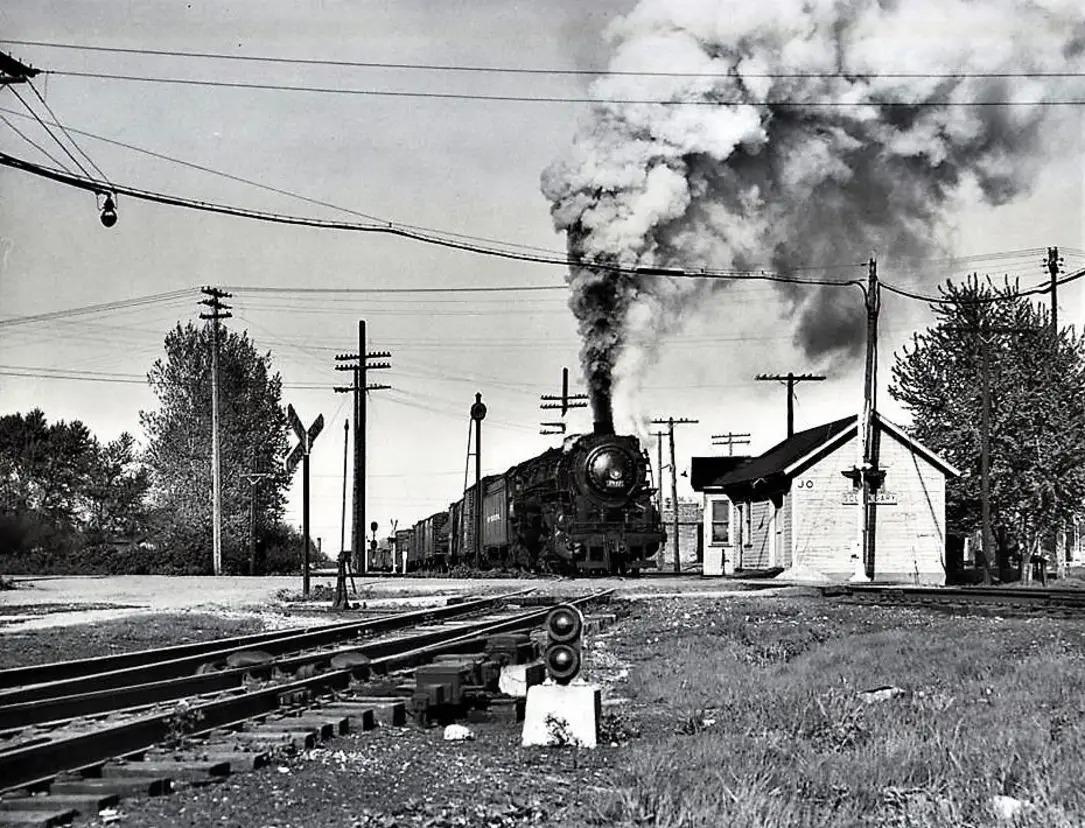
South Gary (JO) Tower: NKP vs. NYC/MC in Gary, IN

(Satellite)

Bob Poortinga commented on John Starzyk's post below
South Gary crossing where the NKP crossed the NYC Joliet Branch. Photo courtesy of Wayne Hudak.
I believe the photo is looking east with a westbound on the Joliet Branch.

John Starzyk posted the comment: "I’d love to a see a picture of where the New York central tracks crossed the Nickel Plate RR in Gary, In."
John Starzyk: It was just a block or two east of Broadway and north of 41st Avenue.
Bob Lalich: John Starzyk - the MC Joliet Branch crossed the NKP west of Broadway and north of 41st Ave. The location was called South Gary. It was a very simple crossing - one track for each RR.
Jason Nanista: If this is looking east, then the crossbucks are for the crossing with Adams Street?
John Starzyk: Jason Nanista that’s what I’m thinking
John Starzyk commented on his post
Here’s an early map of some of the Fr in gary


Tuesday, October 18, 2022

1904 AVR/Pennsy Brilliant Branch Cutoff Bridge over Allegheny River and UY Tower

Tower: (Satellite, not only is the tower gone, but so is the track on the eastern connection.)
Bridge: (Bridge Hunter; no Historic Bridges; pghbridgesB&T3D Satellite)


3D Satellite

Postcard via BridgeHunter, Public Domain

STEAM ENGINES Worldwide posted
Pennsylvania Railroad Steam Engine crossing the Brilliant Branch Bridge - Pittsburgh - Photo by Charles ‘Teenie’ Harris - Carnegie Museum of Art
Bridges Now and Then posted
"Pennsylvania Railroad Steam Engine crossing the Brilliant Branch Bridge - Pittsburgh - Photo by Charles ‘Teenie’ Harris. (Carnegie Museum of Art)

The Water & Sewer Authority land used to have an elegant power plant. A different power plant was standing there in this Flickr Photo.
Image via BridgeHunter via eBook, p259
Fig. 115b. -- Through Pin-connected Parker Truss Bridge over Allegheny River at Aspinwall, Pa., Brilliant Cut-off, Pennsylvania R. R.
 
1 of 3 posted  by Bridges & Tunnels
The Brilliant Branch Railroad Bridge was constructed for the Brilliant Branch of the Pennsylvania Railroad (PRR) and featured a 1,200-foot-long Warren truss bridge across the Allegheny River between Pittsburgh and Aspinwall, Pennsylvania.
The Brilliant Branch, also referred to as the Brilliant Cut-Off, was constructed by the PRR as a cut-off to avoid the busy Union Station and its yards downtown and as the final component of a railroad beltway around Pittsburgh. The bridge opened to traffic in 1904.
In the wake of the collapse of Penn Central (PRR’s successor) and in the midst of the U.S. Railway Association’s controversial $7.3 billion railroad revitalization plan, it was proposed to reroute 25 to 35 through freight trains from the Fort Wayne Bridge in downtown to the Brilliant Branch river crossing. But it was feared that it would cause congestion because of the steeper grades and sharper curves at the wye in Aspinwall. Instead, the Brilliant Branch was abandoned, only to be revived in 1995 for the Allegheny Valley Railroad (AVRR).
The line has only been minimally used since 2019 after the loss of AVRR's only customer north of the Allegheny River crossing.
▶︎ Check out more photos and a history of this unique crossing at


Mainline Photography, Sep 2022

CarloadExpress

Ivan Safyan Abrams Flickr
There were 10-15 locomotives in this "light engine" move across PC's ex-PRR Brilliant Bridge, probably bound for Conway Yard some 30 miles west. That's UY tower just visible at the end of the bridge. 1975.

Ivan's photo not only clearly shows the cut-stone construction of the piers, he documents that there was a junction tower in the wye on the west side. So once again, I fire up the wayback machine to find the location of the tower.
EarthExplorer: Apr 9, 1952 @ 23,600, AR1NZ0000020063

It is off the eastern connection soon after it forks off the bridge.
Digitally Zoomed

Dave Kuntz posted four photos with the comment: "The Brilliant Branch Railroad Bridge in Aspinwall PA.  One leg of the wye has the rails completely removed while the bridge itself rarely sees trains anymore.  A "brilliant" park has been built in the center of the wye.  Plans are underway to turn the entire bridge into a bike trail."
Jay Anthony: Was it ever double track or was the extra space “just in case”?
Ron Mele: Jay Anthony Both legs were built with double track. The west leg had double track well into the Conrail era. The east leg had a single track for as long as I can remember (early 60s). The second track must have been removed a long time ago. The remaining east leg track probably came out some time in the Penn-Central era or very Conrail.
James Ralston: Carload Express (specifically, Allegheny Valley Railroad) owns the Brilliant Bridge, and as of late 2023, still uses the spur tracks on the west split of the wye for car storage. (You can see the cars if you take the Highland Park Bridge northbound and take the Aspinwall exit; you can also see them on Google Maps satellite view.)
Given the upcoming redevelopment of the Sharpsburg waterfront from a former brownfield to commercial/housing/retail (1), I could very well see AVR abandoning the bridge. But if the city wants to rail-to-trail it, I'm not sure what they think they're going to do with the trail on the south end of the bridge, as the AVR line it connects to (the strip district / Oakmont / New Kensington line) is very much active…
Dan McNally: This bridge and the Brilliant line to Homewood are in the process of being purchased by Allegheny River Trails Park. It includes spurs going to 13th street in Sharpsburg, the water treatment plant and half way to Nadine road.
Tim Shanahan shared
1

2

3

4

Dave Kuntz posted four photos with the comment:
This is a news update post as I continue to fix my drone.  The Brilliant Branch Line in Pittsburgh, which I droned last summer, is now set to become a rail trail and the rails will be pulled up this spring.  Go get your abandoned rails while they are still there!  https://community.triblive.com/.../penn.../news/3717357...
Dave Kuntz: "In the coming months, Allegheny Valley Railroad will pull up track from its soon-to-be abandoned Brilliant Branch and use it along part of the Allegheny Subdivision, which follows the south bank of the Allegheny River from Pittsburgh’s Strip District to Arnold."
Chris Carlisle: Dave Kuntz I guess on the flip side we should be happy that the increased business on the Allegheny division is warranting a upgrade. They have been hauling some decent size sand trains up there for the past year.
1

2

3
[This is the Brilliant Branch Cutoff Viaduct.]

4

Mike Graun posted two photos with the comment: "Brilliant Bridge, Aspinwall Pa, near Pittsburgh."
Stephen Walker: Hard to believe there used to be so much traffic coming down the Allegheny River the Pennsylvania built this to divert away from downtown add for traffic coming out of downtown up the river to Redbank and oil city where there’s a bridge just like it.
Mike Braun: Stephen Walker the Oil City wye bridge is no longer used as well. 🙁
Sherpes Hasher: planned to be converted into a bike trail soon.
[Some comments indicate that now it is just being used to store sand cars.]
Tim Shanahan shared
1

2
 
Rick Tonet commented on Mike's post
I have the old UY letters from the two story tower that stood here.

Darren Reynolds posted four images with the comment:
The Pennsylvania Railroads 
"UY" tower 
Aspinwall, Pennsylvania
1

2

3

4

Darren Reynolds posted two images with the comment:
The Pennsylvania Railroads 
"Bridge" tower 
Oil City, Pennsylvania
Samuel Walker: When I resided in Oil City in the 1990's I met the retired operator of the tower. His long time friend was my next door neighbor. He explained that the PRR operated the Titusville line as single direction south and the Warren line as single direction north.He told of a engineer who was notorious for running past the signal circuits for a stop signal. He had done so with a southbound freight from Buffalo from the Titusville line. Coming up the Allegheny River Valley northbound was fast freight to Buffalo from Pittsburgh. With the stop signal fouled, the southbound freight needed to reverse so that the northbound freight would not need to stop. He came up with the plan to have the southbound locomotives reverse and push off the fouled signal point as he south the northbound mile away done the Allegheny. River. This was in the 1950's before the Kinzua Dam was built. The combined noise of the northbound freight and the heavy, loud sound of the reversed diesels covered the action from the yardmaster at the opposite side of the Allegheny River where the Oil City yard was located. Saved the engineer from having been disciplined for running the circuit. Kept the Northbound on time and on schedule.
Ben Schiffer: Samuel Walker That’s a cool story. Hadn’t heard that one. I lived in OC much if my life left in the mid 80’s. My grandfather was an “Engineman” in Oil City from 1940-1976. Ran north up Salamanca Branch and South on the Chautauqua Branch. They called it “going around the world.”
Samuel Walker: Thanks. I had forgotten the phrase "going round the world." My neighbor had been a policeman i the 50's. Seems that a disturbed fellow bought some rope at a local hardware store. Asked what he was going to do with it, he replied, "Well, I think I will hang myself." He laughed. The clerk laughed. He went to the Petroleum Street bridge over the PRR tracks along the Allegheny River. He secured the rope and jumped. The engine crew of a northbound were unable to stop without hitting the swinging corpse.
1

2

Adam Klimchock Flickr
UY Tower; Aspinwall, PA; January 1978
This behemoth of a tower is UY Tower at Aspinwall, PA on the Conemaugh Line. The four story tall structure stood in the middle of the wye on the Brilliant Branch. Apparently the tower was named for Guyasuta, a local Native American. Walkways are seen coming from the tower for the operator to access either leg of the wye should they need to. Sadly, as is expected, the tower is long gone, making it difficult to imagine that such a unique and imposing structure once stood there.
UY Tower. Aspinwall, PA.
January 1978. Photographer unknown.
Adam Klimchock collection.

Dave Kuntz Drone Photos posted four photos with the comment: "Finality of the Brilliant Branch Bridge in Aspinwall, PA.  Currently being converted into a trail.  I'll post the impressive stone arches on this line in a few weeks."
1

2

3

4