I wonder how far up the Galena River steamboats could go back then.
 |
| Dale Click posted Lock and dam at mouth of Galena River c. 1900 |
 |
| Joy Taylor posted The BNSF Four Mile Bridge spans the Des Moines River near Ottumwa and Chillicothe in SE Iowa. |
 |
| JohnMarvigBridges, cropped Located between Ottumwa and Chillicothe, this massive bridge is locally known as the "Four Mile" bridge. The original bridge here dates to the 1860s. However, that bridge was upgraded at least once before this bridge was built. In 1903, the CB&Q double tracked this bridge, building a five span pin connected Pratt Through Truss bridge, approached by seven spans of deck girder on the west, and five spans of deck girder on the east. This iteration of the Four Mile Bridge was one of several spans built by King Bridge Company for this line. Several others, although much smaller spans, were also built during double tracking projects. In 2002, BNSF decided to upgrade the bridge to the current configuration. The five truss spans were replaced with two new riveted Warren Through Truss spans, as well as several beam spans. Unfortunately, this greatly reduced the significance of this bridge. Unaltered, this would have been one of the more significant bridges over the Des Moines River. Today, the deck girder spans still remain, approaching the modern trusses. Several upgrades have been made to the substructures of the bridge since. |
 |
| JohnMarvigBridges [I wonder why BNSF went back to rivets. Generally, high-strength bolts have been used since the 1970s.] |
 |
| Street View, Sep 2024 |
 |
| Street View, Sep 2024 |
 |
| Photo provided by the Smithsonian Institution via BridgeHunter_1888, Public Domain |
Except for the navigation span, the new bridge is a steel girder bridge.- Burlington Northern Railroad (BN)- Chicago & North Western Railway (CNW)- Chicago, Burlington & Quincy Railroad (CBQ)- Chicago, St. Paul, Minneapolis & Omaha Railway (CMO)- Great Northern Railway (GN)[BridgeHunter_1888]
 |
| 2018 photo by John Bernhisel via BridgeHunter_1982 |
 |
| 1955/67 Sioux City Quad @ 250,000 |
 |
| BSNF_network |
 |
| BNSF_subdivision |
 |
| HAER MO,95-SALU.V,1--3 3. EAST WEB, SHOWING PIERS AND SHORELINE; VIEW TO NORTH - Bellefontaine Bridge, Saint Louis, Independent City, MO |
 |
| HAER MO,95-SALU.V,1--31zzz 31. Photocopy of historic photograph, photographer unknown, date unknown. TRAIN PASSING THROUGH SPAN AT NORTH END OF BRIDGE |
 |
| Street View, Jul 2022 |
 |
| Street View, Oct 2022 |
 |
| Street View, May 2013 |
 |
| Street View, Jul 2015 Aug 2019 and Jan 2022 also have standing water in the field. |
 |
| Street View, Jul 2015 |
 |
| safe_image for 1893: A Newly Built Railroad Bridge in Missouri Passes a Crucial Test Photo Credit: Library of Congress "The Bellefontaine Bridge was one of the first bridges to incorporate what is known as the Baltimore truss design." |
 |
| pdf, p 6 via archive via BridgeHunter The Bellefontaine Bridge: a report to Charles E. Perkins, president of the Chicago, Burlington & Quincy Railroad [published 1894] |
 |
| Street View, Sep 2021 |
 |
| Marty Bernard shared a Flickr link CB&Q 4960 taking a fan trip across the Fox River Bridge at Montgomery, IL on June 20, 1965. Please look at it full screen. Robert Chawgo: Beautiful....and the C&S auxiliary water tender. Marty Bernard posted CB&Q 4960 Crossing the Fox River at Montgomery, IL The fantrip was on June 20, 1965. Marty Bernard shared Allen Hartman: Is that an extra water tender ? Jason R Maxwell: Allen Hartman, yes |
 |
| John Burt posted CB&Q covered trestle over the Vermilion River at Streator on the Zearing branch. 1927. The cover was removed in the early 30s. Thomas Whitt shared Wow! |
 |
| John Burt commented on his post This is all that's left of the trestle today. |
 |
| Dennis DeBruler commented on John's post https://www.google.com/maps/@41.1318262,-88.8516792,90m/data=!3m1!1e3?entry=ttu |
.jpg) |
| Dave Kuntz posted Another ghost for you - an abandoned MILW [actually, CB&Q] bridge spanning a mostly abandoned canal near Rock Falls, IL Mike Breski shared |
 |
| Friends of the Hennepin Canal posted Did you know? There are 33 locks on the canal. Thirty-two are still visible. Fourteen of the locks had Marshall gates, which are unique to the Hennepin, and are raised and lowered on a horizontal axis, much like a rural mailbox. Five of the locks have been restored to working condition, although they are not used. (From the Illinois Department of Natural Resources.) Pictured below is the Guard Lock, Sluice Gates and Guard House at the Hennepin Canal in Rock Falls, Illinois in 1907. (Image from University of Wisconsin Madison online libraries.) Logan Fahr: All 33 locks are visible. Gary Wagle: Logan Fahr Actually, Lock #1, in Bureau on the Illinois River, no longer exists...washed out by flooding and neglect. Most all of the other 32 locks exist, in part. |
 |
| Logan Fahr commented on Gary's comment oh its there |
 |
| Hennepin Canal State Park posted Today's Throwback Thursday photo shows the digging of solid rock below the Guard Lock in Rock Falls. |
 |
| Hennepin Canal State Park posted Today's Throwback Thursday picture features the Overseer's House and the Feeder Lock (33) in Rock Falls. Photo taken in 1970. Gary Wagle: This lock is also know as "the Guard Lock" because it is at the canal's headwaters, connecting Lake Sinnissippi (Rock River) to the canal. Adjoining the lock are two Tainter gates which control all of the water that flows through the canal. Currently, this lock and these gates are in major disrepair. If they would fail, Lake Sinnissippi would rush down the Feeder, bursting levees, resulting in dewatering of the canal. Fortunately, the Friends of the Hennepin Canal, an independent 501c3 support group, has secured a $10.2 million commitment from the State for repair of these structures. Requests for construction bids are being processed. Daniel Crebo: That's old man Bonnell sitting on the ground, Hell of a fly fisherman. |
 |
| John Vize posted Birds Eye view of the guard lock from the water tower looking northeast, Sept 28, 1909. Note the volume of water flowing into the feeder canal in this photo compared to now. |
 |
| John Vize posted The Guard Lock on the Feeder at Rock Falls in the early days of the canal. Photo from my collection. Lloyd Scott Hardin shared |
 |
| John Fize posted Feeder guard lock from N.W. Sept 25, 1909.@ |
Lock #33 was also called the Feeder Canal Guard Lock, and was built at Rock Falls to bring water into the canal, and allow boats off of the Rock River to enter the canal system.Here is a general photo of the lock from the north, a closer view of the north gates, and a view of the gate lift mechanism on the sluice gates. The gate lift allowed water to enter the canal or shut off without using the main lock.


 |
| 1946 Sterling Quad @ 62,500 |
 |
| William A. Shaffer posted |
 |
| Chuck Mountain posted Chicago, Burlington and Quincy Rail Road 1883 Dennis DeBruler shared This map shows both routes that went North from Aurora, IL. Of course, the one on the east side of the Fox River was the 1850 Aurora Branch Railroad that connected to the C&NW. That railroad was one of the railroads that formed the CB&Q in 1856. The direct line to Chicago along the Southwest Plank Road did not open until 1863. |
 |
| Aurora Historical Society posted OCTOBER 21, 1850 The Aurora Branch Railroad (later the Chicago, Burlington & Quincy) inaugurates service between Aurora and Chicago, via Batavia and Turner Junction (West Chicago). The 12-mile branch railroad connected Aurora to the tracks of the Galena & Chicago Union Railroad (later Chicago & Northwestern), where it used those tracks and right of way to complete the journey into Chicago. There were two round trips each day. By 1855, the railroad expanded to become the Chicago, Burlington, and Quincy (CB & Q). By the 1920s, the railroad had 12,000 miles of track over 14 states, and the Burlington Route adopted the slogan, “Everywhere West.” Today, the railroad is the Burlington Northern Santa Fe (BNSF). Map – Overton, Richard C., Burlington Route – A History of the Burlington Lines. New York: Alfred A. Knopf; 1965 Jimmy Fiedler: Actually the first train on the Aurora Branch RR was in September 1850 from Batavia to Turner Junction. The line fully opened in October 1850, used a borrowed locomotive from the G&CU called the Pioneer. I doubt the Aurora Branch had direct service to Chicago, but passengers would transfer to a G&CU train. It took 9 hours by railroad to travel from Aurora to Chicago. The Aurora Branch reorganized into the Chicago & Aurora RR in 1852-1855, the line was extended to Mendota from Aurora. In 1856 the C&A RR merged with 5 other railroads & formed the Chicago Burlington and Quincy RR in 1856. The Branch from Aurora to Turner Junction was the CB&Q route into Chicago until 1863 when the line built from Aurora to Chicago was completed. Bob Klein: Eola Rd was named such for End Of Line Aurora [That road is on the east end of Eola Yard.] Robert Wakerly: I'm doubtful that it's the BNSF today as the description states. The BNSF goes thru Hinsdale, Downers Grove and Naperville (not far from Ogden Ave. S.W. Plank rd. On the map) Rather, the Galena and Chicago Union railroad on the map looks like the Union Pacific West line today which goes through Elmhurst, Lombard, Wheaton and West Chicago. Greg Beat: Robert Wakerly Correct. During Civil War CB&Q built from Aurora to Chicago along the S.W. Plank Road. The original 12 miles of CB&Q still largely exists, but ends behind closed General Mills (Cherrios) plant. The “Tower JC" on the CB&Q and crossing/switches are Gone. The.Tower JA" on the CN&W Freeport/Williams Bay Line was closed in 1949 and was moved to the Illinois Railway Museum (IRM) in Union, IL. Tower JB” in Manned and Operational, EJ&E (now Canadian National) Crossing with Union Pacific (former Chicago & North Western) Geneva Subdivision Mechanical interlocking installed 1889 Electric interlocking installed 1901 New tower constructed 1926 John R. Jaros: Larry J. Pearlman The Pioneer was the first train engine in the Chicago region. The Aurora Branch borrowed it from the Galena & Chicago Union RR because they were still waiting on locomotives on order. Today, it can be seen at the Chicago History Museum. |
 |
| Jimmy Fiedler commented on Larry's comment |
 |
| Chuck Mountain posted Chicago to San Franciso via the Burlington Route c.1879 |
 |
| 1879 |
 |
| 1880 |
 |
| Chuck Mountain posted Restored railroad map: Chicago, Burlington, and Quincy Rail Road 1881 [Too bad there was not a link to a high resolution copy of the map. I didn't study it in detail but I happen to notice that it doesn't have the branch that went West from Streator.] |
 |
| 1919 |
 |
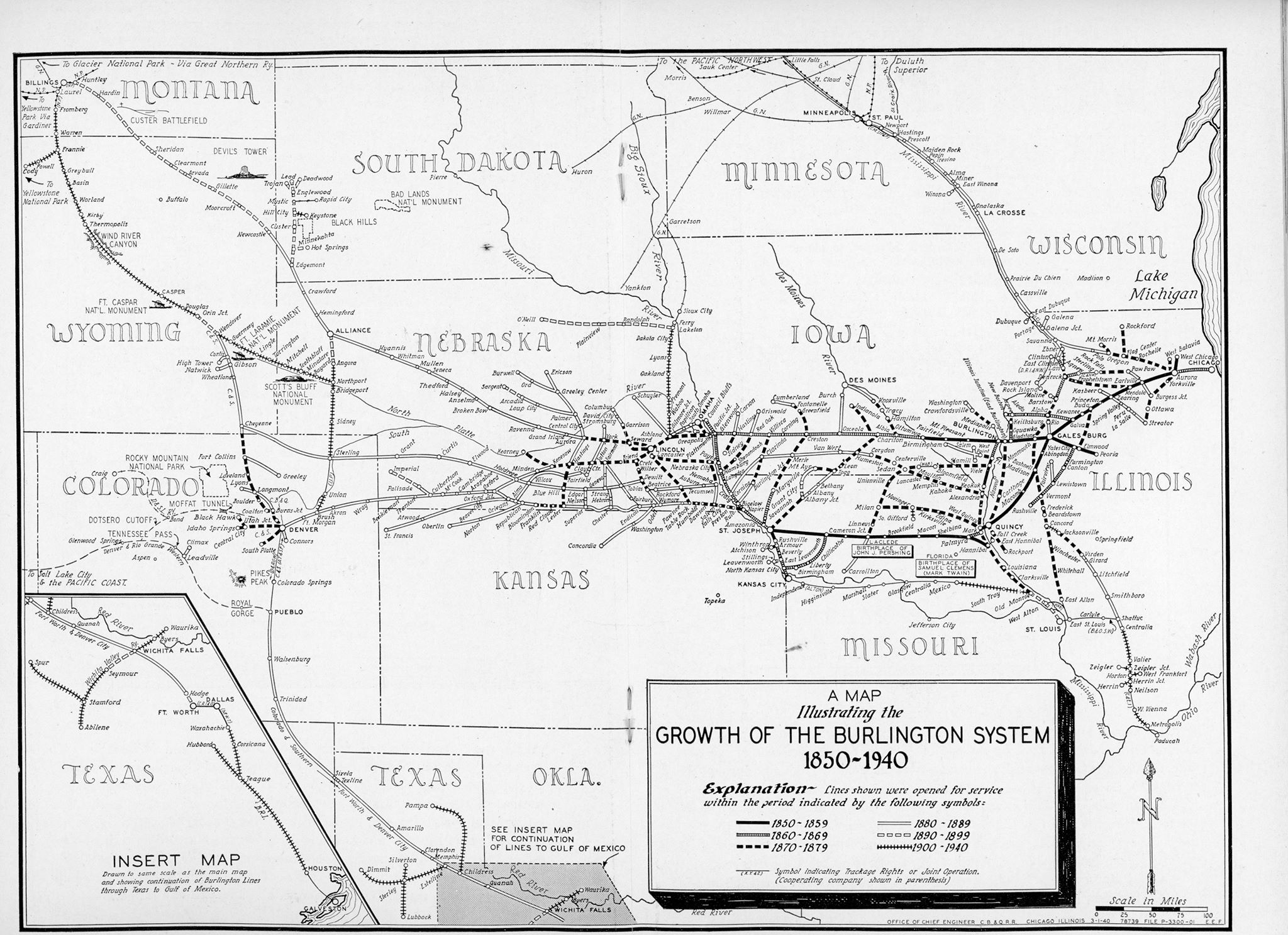
| Chuck Mountain posted Mineral Resources Map of the Burlington Lines 1940 |
 |
| Google API |
 |
| William A. Shaffer posted |
 |
| 1913 Queen City and 1938 Kirksville Quads @ 62,500 |
 |
| D.W. Cole posted on Facebook |
 |
| Abandoned Railroads |


