Showing posts with label powerhouse. Show all posts

Tuesday, August 19, 2025

1970,2020 110mw Robert S. Kerr Lock & Dam on Arkansas River near Sallisaw, OK

(Satellite)

Street View, Sepo 2024

USACE, Tulsa District

The 7,230' (2.2km) long dam has a maximum height of 75' (23m) above streambed. The 900' (274m) long spillway has "eighteen 50- by 44-foot-high tainter gates" with a capacity of 1,542 kcfs. The lock is a standard 600x110 with a normal lift of 48' (14.6m). The powerhouse has four "27,500-kW Kaplan-type units." Each unit can discharge 34,000 cfs at rated capacity and 41,000 cfs at full overload. [USACE_data]

I wonder where the towboat operates that requires a retractable pilothouse.
okhistory, Credit: Oklahoma Historical Society, photo by Jim Edmond

Andy Michel posted 14 photos with the comment: "Some cool photos I took during our tour of Robert S. Kerr Lock & Dam.— with Joshua Cox and Joe Bodolay at Robert S Kerr Lock & Dam 15."
1

2

3

4

5

6

7

8

9

10

11

12

13

14

Andy also included a video.
Screenshot 1

Screenshot 2

Andy Michel posted
Got an awesome tour from Joshua. 
Thank you very much!!!— with Joshua Cox and Joe Bodolay at Robert S Kerr Lock & Dam 15.

Sunday, August 17, 2025

2025 1.2gw BC Hydro Site C on Peace River near Fort St. John, BC

(Satellite)

Aug 9, 2025:
CoastReporter
BC Hydro says Site C dam near Fort St. John now fully operational
"BC Hydro's Site C dam and hydroelectric generating station on the Peace River is seen in this handout photo near Fort St. John, B.C., on Nov. 6, 2024. THE CANADIAN PRESS/Handout - Site C Clean Energy Project (Mandatory Credit)"
"With a final price tag of $16 billion, nearly double its initial price tag, the dam is considered B.C.'s most expensive infrastructure project." Construction started in 2015.

sitecproject_reservoir
The reservoir began to fill on Aug 25, 2024, and it took 11 weeks to complete.

The satellite image I accessed on Google Maps on Aug 14, 2025, is older than a year because the river is still being diverted.
Satellite

Slide 4, Nov 6, 2024

The gates for the three higher spillways are obviously Tainter gates. Are the gates for the six lower spillways sluice gates? Unit 6 was the last unit to come online, and it looks like it is the closest one in this view.
Slide 23, Sep 16, 2024

bchydro
The earth fill dam was completed in Nov 2023. It is "a kilometre long, half a kilometre wide at the base, 20 storeys high, and made of some sixteen million cubic metres of sand, clay, and rock."

Facebook Reel

Wednesday, August 6, 2025

State Street Bridges over, and Dam on, Oswegatchie River in Heuvelton, NY

1870s Bridge: (Archived Bridge Hunter; Bridge Hunter)
1917 Bridge: (Archived Bridge Hunter; Bridge Hunter; no Historic Bridges; Satellite)
1923 1mw Dam: (Satellite, it has a fish ladder on the south side.)

Behind the pole in the center is part of the fish ladder.
Street View, Jun 2025

Bridges Now and Then posted
Construction on Heuvelton’s concrete bridge in 1916. Heuvelton, NY. (North Country at Work)
Art Suckewer: The old bridge is an 1870s Wrought Iron Bridge Co. bowstring through truss.

Postcard via BridgeHunter_1870s

It looks like 2 of the 6 trunnion gates have been replaced.
Street View, Sepo2018

Are the replacements movable?
Yes. Data calls them "Other Controlled2." But I couldn't figure out how to look up the meaning of "Other Controlled2." Are they inflatable?
Street View, Jun 2025

NorthCountryAtWork
The dam was constructed in 1923.

NorthCountryAtWork

The dam is 284' (87m) long and 19' (6m) high with a hydraulic height of 35' (11m). [data]
The 2 units have a combined capacity of 1mw. [HydroReform]

Saturday, July 19, 2025

1954 320mw Fort Randall Dam (Lake Francis Case) on Missouri River at Pickstown, SD

(Satellite)

The spillway is on the right, the powerhouse is right of center, and earthfillgated  counties out-of-frame to the left.
Street View, Aug 2024

USACE

This is the spillway. This is the outlet works. The outlet works are connected to the same intake structure that the powerhouse uses. It disturbs me that a USACE web page would confuse a spillway with an outlet works. This photo is of the outlet works, not the spillway.
USACE
"During normal operations, USACE releases up to 44,500 cubic feet of water per second through the powerhouse. One cubic foot of water, or cfs, is equal to 7.5 gallons. The outlet tunnel can release an additional 128,000 cfs. The spillway was designed to additionally release up to 633,000 cfs. For perspective, the largest release of water from Fort Randall Dam as a result of flooding was a combined 160,000 cfs from the powerhouse and spillway in 2011. It is important to understand that the dam is designed to release up to 805,500 cfs when necessary and that dams do not eliminate flood risk."
[128kcfs is more water than many gated spillways can release. I wonder what the downstream river can handle without flooding.]

This is what the spillway looks like.
USACE
"Omaha District completed several risk reduction actions at Fort Randall Dam after the flooding of 2011.  These include installation of additional instrumentation to enhance foundation monitoring. Numerous repairs have also been made to the spillway to improve its resiliency during future flood events." [This sounds like another USACE spillway that did not perform as intended when it had to be used.]

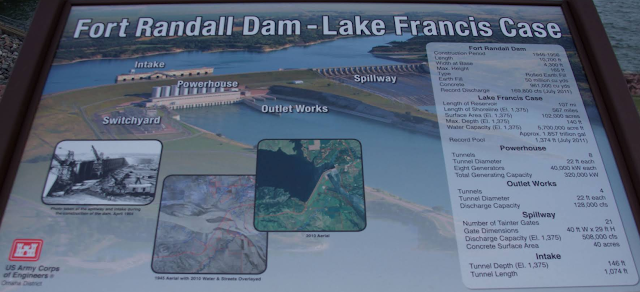
I could not find statistics about the dam on the USACE web page such as length, elevations and conservation & flood pool capacities. Nor on any other page on the internet. But then I did find this.
Donald Regan, Mar 2016

Digitally zoomed

lewis-clark

It is a shame that they don't provide enough resolution so that we can easily read this graphic.
USACE

This was the post that motivated these notes.
2:11 video
he Fort Randall Dam is taking on a massive modernization effort as the Major Unit Rehabilitation Project is officially in motion!
Components for the first of eight massive new units began arriving on-site in late June 2025. Standing more than three stories tall, each unit is a towering feat of engineering.
Over the next eight years, all existing units will be carefully removed and replaced, marking one of the largest upgrades in the dam’s history.

Tuesday, July 8, 2025

1964 6mw Canyon Lake Dam on Guadalupe River in Canyon Lake, TX

(Satellite)

Street View, Jun 2023

USACE, Fort Worth District

July 4, 2025, Flood


This is the first reservoir on the Guadalupe River that the deluge of the catastrophic July 4, 2025, flash flood first encounters. It was so empty because of a drought that it easily absorbed all of the water. But here is an example of social media sensationalism. Fortunately, several comments called them out on it.
Economic Hell posted 0:46 video
Canyon Lake water level increased by 10 feet as torrential rains flood the Guadalupe River. With just 66 feet left before spillage, residents are urged to evacuate die tobthe floodings. Six dead so far — and more rain is coming. Stay alert, Texas.
Robbin Homan: This is not true.
I own a house on lake Dunlap, Canyon lake was about 30’ below normal. It took in all of the flood water and only rose about 10’. It could handle three times what it got. This is exactly what the lake was built for.
[Another comment indicates that the water level still hasn't reached some of the boat ramps.]

They had to use an old photo to make the lake look nearly full. A comment provided this photo.
Diana Holcomb Coffey commented on the above video

USACE

"The Texas Water Development Board reported that Canyon Lake, as of noon on Monday, was up nearly 11 feet from a week ago and stood at nearly 889 feet or nearly 62% full. Its full conservation pool sits at 909 feet. It was 46% full before the rains over the Fourth of July weekend." [tpr]

I dug deeper to find the flood pool elevation: 943'.
gbra
 The dam is 224 feet high and 6,830 feet long.
At Conservation Pool elevation of 909 feet mean sea level (msl), the Reservoir covers approximately 8,200 surface acres and impounds 378,852 acre-feet of water to a depth of 140 feet.
At maximum Flood Control Pool elevation of 943 feet msl, the Reservoir impounds a total of 732,600 acre-feet of water.
The Emergency Spillway is at 943 msl.

Even if the lake had been at conservation pool (the desired level), it would have handled the flood waters. The water can rise 34' above the conservation pool before it would go over the spillway. And the 10' rise would have been less at the higher level because the lake rises slower as the lake goes up because it spreads out over more land. When the lake reaches the conservation pool, the USACE releases 12kcfs until the level is back down to the conservation pool.

When they talk about the lake being 62% full, I believe the conservation level is considered full. The dam can hold 732,600/378,852 or 193% full.

gbra
The 6mw powerhouse began generating electricity in 1989.
The lowest level of the reservoir was 877.49' on May 13, 2025, and the spillway has been topped only once, in 2002.

It will be a while yet before the lake can be used for recreation because it is now full of debris. And it is still well below its normal level.
My Lake News posted 0:23 video on July 5 at 2:51

Facebook Reel

The people in the Canyon Lake area have to boil their water because that lake is the source of their water. [0:08 video]

Jul 14, 2025:
Comal County ESD No. 3 (Canyon Lake Fire / EMS) posted
In-state and out-of-state emergency service resources will be in the Canyon Lake area assisting with Search & Recovery Operations related to the recent floods. By bringing in these Fire Departments and other services from outside the local area, it prevents local resources from being overwhelmed.  These responders are part of a coordinated Local, State & Federal response. We ask that you please avoid the areas where you find search operations underway and show them the support and kindness that this community has always shown for Canyon Lake Fire / EMS.
  Thank you
Leanna Lynn Girven: I dropped my son off at CLHS today and there were three 18 wheelers from Tennessee search and rescue, a bunch of boats, people from Texas A&M rescue, Harris County among lots of others. It was a wonderful thing to see. God bless them all!
[My first reaction was who are they looking for because the lake is closed. And then it occurred to me that they are looking for the missing people that got washed down the river. There are still over 100 people missing.]
Cynthia Rowzee Abraham: They have asked everyone to stay off the lake the water is very toxic with the water flowing into it from the Guadalupe River it’s full of Bacteria. The Guadalupe River contains high levels of fecal bacteria, including E. coli and enterococci, especially after heavy rainfall or flooding. These bacteria, found in animal and human waste, and decomposing animal and human remains can pose a health risk to those who swim or wade in the water. Not to mention the oil, gas and antifreeze that went into the water with all the automobiles. People need to stay out of the water until they can determine if it’s safe!
David Allan Hall: The boat ramps 1,18,19 are open for boat launch for your boat repair, engine check, trailer repair…
It is closed for recreational activities, fishing, water skiing, swimming or just running around the lake in your boat.
The lake is full of debris, bacteria of all types from decaying plants, animals and other non-mentionable from the recent flooding into the lake. [This comment was in response to some comments saying the lake was open because these ramps were open.]