Showing posts with label rrBRC. Show all posts

Saturday, May 31, 2025

BRC 55th Street Junction Tower: BRC vs. BRC+IHB

Old: (Satellite, according to the aerial photo below, the tower was in the southwest quadrant.)
The connecting track behind the tower didn't make sense for the southwest quadrant so I dug deeper and discovered a newer tower was in the northwest quadrant.
New: (Satellite)

Edward Kwiatkowski posted
The Belt Railway Of Chicago's 55th Street Junction tower near Chicago's Midway Airport. Chicago Illinois, April 1984. ( Gone,)
Edward Kwiatkowski photo.
Jim Kelling shared
Chicago Belt Railway at 55th Street on the South Side
Tim Shanahan shared

This BRC train is heading geographically North.
NorthAmericanInterlockings_Illinois
[Back in the signalling pipelines day.]

NorthAmericanInterlockings_Illinois

NorthAmericanInterlockings_Illinois
Dennis DeBruler commented on Jim's share
This is the new tower, and it was in the northwest quadrant of the crossing: https://maps.app.goo.gl/rSMN7YdiN5HWt4cc6. Diagram is from https://northamericaninterlockings.com/illinois_9.html.
Dennis DeBruler also commented on Tim's share

1938 Aerial Photo from ILHAP

Dec 4, 1951 @ 23,600; AR1SA0000020018

BRC had both a north/south and east/west route through this crossing. The IHB had an east/west route through the crossing.
1953/56 Berwyn and Englewood Quads @ 24,000

Wednesday, March 8, 2023

BRC over 47th Street in Chicago, IL

(Satellite)

Again, I don't normally note railroad overpasses because in the Chicagoland area that would effectively be spam. But this historical photo is worth noting because of how empty the neighborhood was back then and because of the Art-Deco decorations.

The Belt Railway Company of Chicago posted
A little quiz!
Check out this beautiful Art-Deco style concrete bridge built in 1946. 
So, where is this bridge located?
Hint: The railroad tracks supported by this bridge are part of the BRC's busy Kenton Line.
Michael Riha shared

BRC commented on their post
If you guessed 47th Street (vicinity of 47th and Knox)-- you are correct! The bridge is still in use and in pretty good shape.
Paul Musselman: Look at how empty the 'hood was....!!
Patrick Cunninghamhttps://www.google.com/.../data=!3m6!1e1!3m4...

Dennis DeBruler commented on Patrick's comment
I see that it was painted after Sep 2019.
https://www.google.com/.../data=!3m7!1e1!3m5...

Dennis DeBruler commented on Michael's share
A lot of this area didn't even have streets back in 1929. And Midway was yet to be built.
1929 Englewood Quad @ 24,000


Monday, December 26, 2022

Corrugated box factories are still rail served

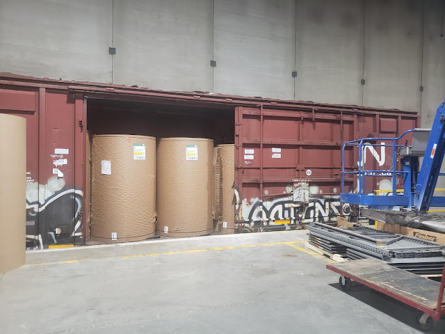
Corrugated box factories receive big rolls of paper. 
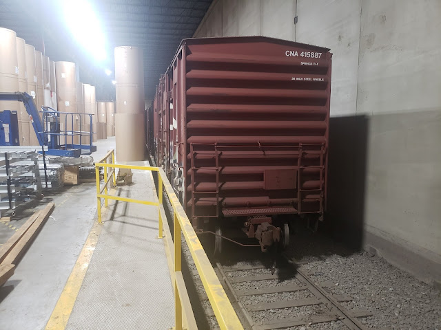
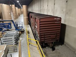
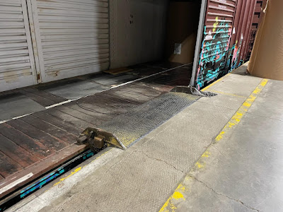
Chris Engstrom posted
Spur that ends inside a cardboard box factory. Nothing special really, but might be interesting to the folks who haven't seen them from the inside.

The comments on the above post taught me of four paper factories that are still rail served.

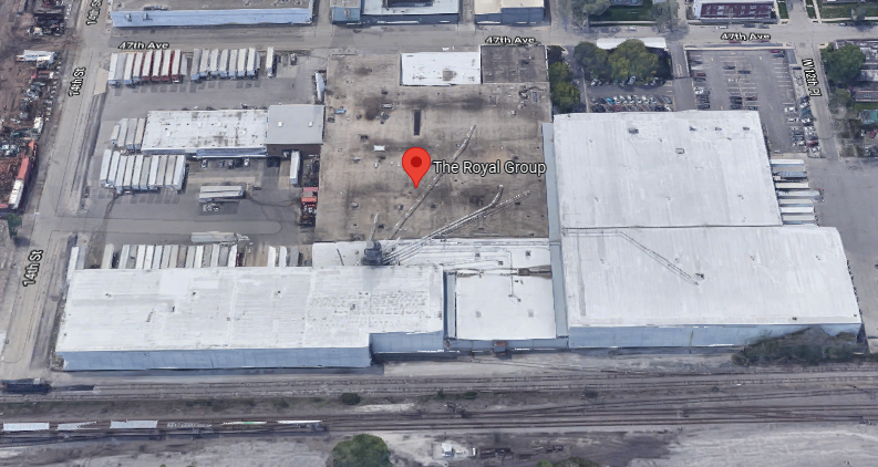
The Royal Group has an enclosed unloading dock and is served by the BRC. 
3D Satllite

The Case Paper Co. does not have an enclosed unloading dock, and it is served by NS/NYC/Chicago Junction. (Case makes a lot of different paper products. I don't know for sure that this one makes corrugated boxes. In fact, I think I read a comment years ago that this plant cuts and packages paper.)
3D Satellite

The International Paper Co. has an enclosed dock. It is next to a remnant of an Illinois Central route. That remnant is now an industrial spur to UP/GM&O. Again, I don't know if this location does corrugated boxes. But it is an example of unloading paper with an enclosed dock.
3D Satellite

Liberty Carton Co. has an enclosed dock. It is served by Canadian Pacific/Minneapolis, Northfield & Southern. I noticed that they share the building with Liberty Plastics. I wonder if this plant receives plastic pellets as well as paper from the railroad.
Satellite

Chris provides three more photos of the paper roll unloading operation as comments on his post.
1
[When I saw Chris' first photo above, I was surprised that the boxcar was not a hi-cube boxcar since they were developed for the paper industry. But this photo shows why they are using plain boxcars. The extra height still would not allow them to stack the rolls double-high.]

2

3


I further researched the corrugated box industry.

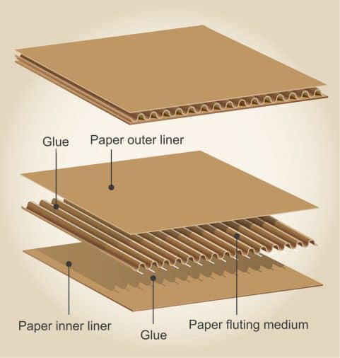
The boxes are made with corrugated paper.
Staunton I. Cottrell comment on Chris Engstrom's post
The rolls of paper are run through a massive machine that corrugates them first. Three, sometimes five of those 3,000 pound rolls running on that corrugator at the same time to make corrugated paper.
[Another comment indicates that some plants recieve 6,000 pound rolls.]

Part of a Georgia-Pacific corrugator.
13:33 video @ 0:24

Here is part of the corrugator in the Royal Group in Cicero, IL.
Chris commented on his post, cropped

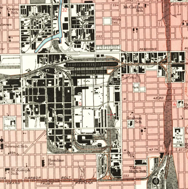
Digging deeper into the rail service. Here is what Chicago used to look like in the vicinity of Case Paper.
1953 Englewood Quad @ 24,000

And this is what is left today. I would not be surprised if some of those industrial spurs are no longer used.
USGS

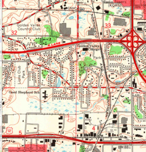
When the Liberty Carton plant was built, an industrial spur was built from the Minneapolis, Northfield & Southern to serve that plant. Canadian Pacific now has that route.
1967 Minneapolis South Quad @ 24,000


Saturday, August 28, 2021

Rail to Water Transfer Dock on Calumet River

(see below for satellite information)

Mike Delaney posted
W.W. Holloway at rail to water on the Calumet River Chicago.
Robert Haller: Days of old, made many loads up to Valley Power Plant in Milwaukee.
 
Growing up in Chicago posted
1951 - Freight trains and ore thawing at 101st Street and Calumet River railyards.
Terry Spirek: These locomotives are from the Burlington Route , and on loan to the steel mill to help to thaw out the ore in the hoppers . .
Joseph Obrien shared

Marine Historical Society of Detroit posted
The whaleback tanker Meteor tied up at the Rail to Water Transfer Corp. facility in the Calumet River. Unknown date. J.R. Williams photo from the Jim Bartke/MHSD collection.
  • Association for Great Lakes Maritime History 
    Follow
    Launched in 1896, what would become the whaleback freighter Meteor was built in West Superior, Wis. by the American Steel Barge Co. Christened the Frank Rockefeller, the 380-foot vessel (LOA) was designed to carry bulk cargoes and tow one or more unpowered whaleback barges to increase its cargo capacity.
    The American Steel Barge Co. was founded in 1888 by Capt. Alexander McDougall, the inventor of the whaleback design. McDougall’s goal was to create a new type of vessel that could be built using relatively low-skilled workers. In addition, those vessels would be capable of carrying heavy cargoes of iron ore in a wide variety of weather conditions.
    The Rockefeller operated in the iron ore trade on the Great Lakes initially as part of a fleet of whaleback freighters and barges leased and managed by the American Steel Barge Co. of Buffalo, New York. In 1900, the fleet was sold to the Bessemer Steamship Co. which became part of the Pittsburgh Steamship Co., a subsidiary of the U.S. Steel Corp., in 1901.
    During the winter of 1925-26, the ship’s cargo hold was rebuilt and strengthened. One year later, the vessel was sold to the Central Dredging Co. of Chicago which planned to convert it into a self-unloading dredge. However, after only minimal work was done, the whaleback was returned to service as a bulk freighter.
    In 1928, the vessel was renamed the South Park. Early in the Great Depression of the 1930s, it was laid up after Central Dredging ceased operations. In 1934, the ship was sold to Maurice H. Sobel of Detroit, Mich. who sold it in 1936 to the Nicholson Transit Co. Nicholson then sold it to the Erie Steamship Co. later that same year.
    In 1942, the whaleback went aground and was wrecked near Manistique, Mich. After being recovered, the vessel was towed to Manitowoc, Wis. It was then laid up there until 1943 when it was sold to Cleveland Tankers, Inc. The ship was then converted into a petroleum tanker at Manitowoc by the Manitowoc Shipbuilding Co.
    After work was completed, the vessel was renamed the Meteor. On Nov. 21, 1969, the tanker went aground and wrecked near Marquette, Mich. After recovery, it was towed to South Chicago, Ill. for repairs. Once repaired, the ship was towed to Manitowoc, Wis. where it was permanently laid-up.
    In 1972, the Meteor was sold to the City of Superior, Wis. for use as a museum ship and is now on display on Barker’s Island in Superior. The vessel was inducted into the National Maritime Hall of Fame at the American Merchant Marine Museum in Kings Point, New York in 1984.
Marine Historical Society of Detroit shared
The whaleback tanker Meteor tied up at the Rail to Water Transfer Corp. facility in the Calumet River. Unknown date. J.R. Williams photo from the Jim Bartke/MHSD collection.
Mark Janovec: Great photo! I'm so used to seeing her in Superior as a museum that it's nice to see a photo of her when she was still active.
Dennis DeBruler commented on the above share
It is also nice to see what the facility looked like. Today it is just brownland.
https://www.google.com/maps/@41.711555,-87.5469954,664m/data=!3m1!1e3

Lou Gerad posted
Robert C. Norton at Rail to Water in South Chicago, 1974.
Dan Vandenberg: Great picture! In more recent years called KCBX. Now I'm wondering...is KCBX still shipping coal from there? Haven't seen much posted on boats loading there recently.
Comments on Lou's post

That would be part of the Rail to Water on the left and the 100th Street Bridge is in the air.
Mike Delaney posted
The International heading up river on the Calumet. Anybody who has heard the horn on this thing would know which one it was long before you saw it. I know I posted this shot before somewhere but it shows the care and pride these companies took in their vessels no matter how old. Both this and the Harvester were in mint and I mean mint and pristine condition. I wish I could have sailed in that tiny fleet. She was my favorite oldy and it was my pleasure to see her up close. I almost cry when I look at this shot. Boat gone, International Steel plant is gone.
[The steel plant it was headed to was Wisconsin Steel.]
Scott Liberty: Many people don’t know that the red and black IH logo is an abstract representation of a man on a tractor.
[Some comments include a couple more photos of the ship on the Calumet river.]

A facility to transload coal from rail to ships became obsolete when power plants switched from Illinois Basin coal to Power River Basin coal. Then local refineries switched to processing crude oil from Canadian tar sands. The residue product from that oil was petcoke instead of asphalt. So the facility switched to transloading petcoke to ships.

But the dust blown off the piles was a serious pollution hazard, so then it became nothing.
Satellite, accessed Jan 2020

Mike Delaney posted
Calumet River Chicago.  Cliffs Victory on the left and some foreign rusted out crapcan on the right at Rail to Water.  This was during a brief iron miners strike so the Victory was layed up wet.  Lots of opinions on the Calumet, Rouge and Cuyahoga rivers as far as pollution goes.  We kicked up a dead body in this river with the bow thruster on the Grace heading for Interlake Iron farther up the river.  Didn't get to see it myself.  Did the same thing in the Cuyahoga on the Snyder Jr. backing into the turning basin coming from Republic Steel with the prop.  I did get to see that one.  The deceased was wearing a brown suite covered with crabs.  The Coast Guard came and picked up the body put him in a bodybag with his feet sticking out layed him on the rear platform on the outside back of the boat and down the river they went with several pleasure boats following taking pics.  Couple years later on the Ayers I was being lowered to the J&L steel dock on the Cuyahoga river, they lowered me too soon, too fast, and I ended up in the water up to my chest and was between the boat and the dock in between two giant earthmover tires hanging from the dock as the boat came in.  took four guys to pull me back up and out enough to climb onto the tire.  Everybody was heaving the blocks over and bedlam was going on the deck as man overboard was called.  I got back on board wearing about 20lbs of Cuyahoga river.  mate says you OK, I said great time for a swim.  Says go take a shower and wash your clothes your done for the night.  I would rather have swam in the Rouge.
[That is the 100th Street Bridge in the foreground.]

Today conveyor belts have developed well enough that the material is stored in piles. Before that, coal was stored in hopper cars. That is why most of the land back then was used for yard tracks. Then a lot of those tracks were removed to create land for the storage piles. You can see that evolution of hopper to pile storage in the still active coal docks in Newport News, VA.
Bob  Lalich commented on Nick Fry's share
Here is a Life magazine photo of the elevator taken in 1951.
Bob Lalich Dennis DeBruler - the hoppers are coal for Rail To Water.

Dennis DeBruler replied to Bob's comment
This photo shows the many tracks north of the elevator in this 1977 topo was used for storage. Are those iron ore cars? They look rather short.

John W. Barriger III National Railroad Library Flickr
[The south side of the yard and a ship in the background.]

John W. Barriger III National Railroad Library Flickr
[The north part of the yard and the Com Ed 100th St. Generating Station in the background.]

Bob Lalich Flickr, Aug 1984
BRC 100th st Yard
BRC TR4 set switches Rail To Water near 100th St, 8-84.

Jim Prrfan posted
Rail to Water dock on Calumet River 4-1968. Steel Mill related.
Jim PRRFan photo
Dennis DeBruler shared to Southeast Chicago Historical Society
https://www.google.com/maps/@41.7117017,-87.5474876,786m/data=!3m1!1e3
Daniel Kleszynski: RTW was opened in 1948. At one time it was owned by 7 coal mining companies. The docks as seen in the photo were constructed in 1954-1955. The North ship loader (closest on in the picture) was the original stationary ship loader.
Dale Windhorst: I just recently found out that it was built by the Chicago and Western Indiana RR. [The BRC was created from the freight operations of the C&WI. [Dennis DeBruler]]
Jeannie Caturano Leinweber: I worked at RTW during the summer before I left for college. I was working on site for an engineering company that was rebuilding the facility after a disgruntled employee torched it!
Daniel Kleszynski: Jeannie Caturano Leinweber that was in 1976.

Larry Candilas commented on Jim's post
Around the same time but a lot slower day with the river traffic.

Thursday, August 12, 2021

Cragin Junction: BRC vs. Metra/Milwaukee and Aban/C&NW

(Satellite, tower was in the northeast quadrant.)

Thomas Manz posted
Cragin Jct which way are we looking? Hemry Wilhelm photo
Bob Lalich: The view is east and the passenger train is WB. Then and now, the passenger mains are north of the freight mains. Also, the tower was in the NE quadrant of the crossing.
 
Jon Roma commented on Thomas' post
Here's a crop of a Milwaukee Road right-of-way map showing the crossing at Cragin. The C&NW track runs due north/south about two blocks east of Cicero Ave. I left some of the cross street names in here for context. You can see the location of the tower on this map.
In case anyone's missed the commentary (thank you, FB), this photo was taken along what is now the Metra Milwaukee West line. The photographer is facing Chicago, and Elgin is to his rear.

Dennis DeBruler posted
While I was looking for the Grayland Junction, I found a Milwaukee vs. C&NW junction further south (pin drop).
41°54'50.0"N 87°44'28.4"W
This junction raises a couple of questions.
1) What is its name?
2) Did it control the connection to the BRC just to the West? If not, what is the name of the BRC vs. Metra/Milwaukee junction?
3) And the second question raises the question of where is the transition of ownership on this route between Metra and Canadian Pacific?
Larry Amaloo: This area was and is still called Cragin Jct., http://chicagorailfan.com/mainrftt.html states that for many years it was controlled remotely from Tower A5 but does not say a specific year. CP ownership of the Elgin Subdivision infrastructurewise does not start until Randall Road if I am not mistaken.
Dennis DeBruler
Admin
Larry Amaloo I found that it was remoted from Tower B-12:
"6.4 Cragin Jct. (remote-Tower B-12 Dispatcher)"
Larry Amaloo: Dennis DeBruler That's for the current day junction with the BRC, the previous junction with the CNW and BRC when it was still a diamond crossing was remoted to A5 until presumably when either the diamond removed or when Metra took control in the 1980s
Andre Kristopans: Crossing to the east was with CNW line from Mayfair to 40th St Yard. Gone south of about Palmer where last customer is.
[The "last customer" that Andre mentioned is Alpha Bakery.]
Glen Koshiol: BRC/MILW. connection was Craigin JCT.