Showing posts with label rrCGW. Show all posts

Wednesday, August 6, 2025

DME/CGW Bridge over Zumbro River in Rochester, MN

1883: (Archived Bridge Hunter; Bridge Hunter)
1908: (Archived Bridge Hunter; Bridge Hunter; no Historic Bridges; Satellite)

DME = Dakota, Minnesota & Eastern

Marty Bernard posted
Moving a Depot Across a River Bridge
Winona & Western Depot being moved from 4th to 2nd St. SE over the Zumbro River, Rochester, MN.  Olmstead Historical Society photo, Walt Dunlap collection
I have now learned that this is only 1/2 the station.  It was cut in half and each half moved separately.

Did they build a trestle bridge for the move or was there a trestle bridge before the truss bridge?
Oliver Hammond FlickrLicense: Creative Commons Attribution-NonCommercial-ShareAlike (CC BY-NC-SA)
Then & Now - CGW bridge 1908 Flood 2
The angle isn't quite right, since the modern street is much wider than the 2-lane bridge the 1908 photo was shot from. I would have had to stand in the middle of 4th St to accurately recreate the shot.

Postcard provided by Oliver Hammond via BridgeHunter_1881

Street View, Oct 2016

1939/39 Rochester Quad @ 62,500

Saturday, October 12, 2024

Trail/CGW overpasses for UP/C&NW and Grace Street in Lombard, IL

Grace: (Satellite)
UP/C&NW: (Satellite)

Rick Burn posted
Chicago Great Western westbound in January 1965 Grace Street Lombard IL

Dennis DeBruler commented on Rick's post
I wonder who paid for the new bridges for the Great Western Trail over Grace Street on the left and UP/C&NW on the right.
 https://maps.app.goo.gl/j7gAJmRJjPmHRiKN7
Mark Petersen: Dennis DeBruler You did as a taxpayer.

They put some sharp curves in the trail so that they could build shorter bridges.
Satellite

I got an old aerial photo to confirm that the CGW went straight over the C&NW. That is why the bridge in Rick's photo is so long for an overpass. I discovered that the route for St. Charles Road has been significantly changed.
1939 Aerial Photo from ILHAP

Saturday, May 13, 2023

IC Branch and a Quarry in Hillside, IL

(Satellite)

Proviso West High School posted
A fantastic bird's eye of the old Hillside Quarry which was located at Mannheim Road and 290. This photo is from around 1980.
"Although farming was the major occupation in the 1850s, Marion Covell discovered a large deposit of limestone just a few feet below the surface of his property. The quarry that he began in 1854 continued to operate until the mid-1970s, supplying crushed stone for road-building throughout the Chicago region. Against the wishes of most village residents, the quarry was acquired by the John Sexton Company in 1979 and used as a sanitary landfill."
John Ryan: Is this now a landfill?
Proviso West High School: It was covered in 2008 per this Tribune article.
https://www.chicagotribune.com/news/ct-xpm-2007-04-13-0704120601-story.html
Proviso West High School shared
Hillside quarry
Stephen Belcher: In the summer of 1962, I was employed at what I remember as Consumers Concrete and Gravel that ran this facility. We did ready mix concrete and road gravel. I was in quality control to make sure the gravel met specifications and that the concrete had the proper mixture of air. At that time there was an expansion at O'Hare and our gravel was loaded from here and taken to form the basis of runways and taxiways.
And always liked that little bridge with train tracks which crossed the Congress there....and breakfast at the bowling alley....lol
Joe Newman: And, boy did that landfill STINK!
Thom Techman: Joe Newman It was Horrible, wasn’t it ? It didn’t matter if you kept your car windows closed, it still got in.
Ardens Acres: They use to sound a siren everyday before they set off dynamite
Jim Vondrak: I remember in the late 60's that on Fridays at around 3:00, the school would shake because they were blasting at the quarry.
[There are several more comments about the smell and the bangs. And a boy who died when he fell in while chasing rabbits under the fence in the late 1960s.]

3D Satellite

The Illinois Central had a branch that went North between the quarry and Mannheim Road. It joined the right-of-way of the CA&E Branch to continue north to connect with the Chicago Great Western Railway. In addition to this topo map, I used the 2005 SPV Map to confirm the route of this IC branch. I don't know the official name of the branch.
1953 Elmhurst and Hillside Quads @ 24,000

1927 Hinsdale and 1928 Elmhurst Quads @ 24,000 via Dennis DeBruler

Sunday, June 6, 2021

B&O, B&OCT, CGW and Pere Marquette freight houses along the south branch

(no Satellite because these railroad facilities are long gone. These facilities were on the east side of the South Branch between Harrison and Roosevelt.)

The straightening of the river in the 1930s had a big impact on the B&O facilities in downtown Chicago.

I start with after the straightening because I have just one photo of that. And because this material was moved from the Roosevelt Road Bridge post.

I used the bridge in the background of this photo to determine where this B&OCT locomotive was running. Once I identified the bascule bridge as the Roosevelt Road Bridge, I remembered that the B&OCT was the terminal railroad for the Grand Central Station, and B&OCT had tracks on the east side of the South Branch from their bridge to the station. This freight house was built after the river was straightened and did not yet exist in the 1938 aerial photo. B&OCT had several small freight houses that fed LCL freight to B&OCT's main classification freight house. It has the classical design for a freight house --- a multi-story building with lots of windows at one end for the office workers that is attached to a one-story freight handling building. In the days of LCL freight, there were no computers, so it took a lot of office workers to help process the paper work. Each boxcar had a folder that contained the waybills of the containers that were in that boxcar. After the LCL freight was sorted in Chicago to a destination train, the conductor on that road train would get these folders along with the waybills for the carload traffic. They would have to determine from the waybills in the folders which containers were to be dropped at which depot along the route. These containers could range from a refrigerator sent by a mail-order house such as Sears to a plow. Remember, in the 1800s everything came to town on the railroad. That is why depots had a passenger weighting room on one side and a freight handling room on the other side. The depot was the life blood of the town.
Scott Griffith posted
Les Wuollett Waiting at dwarf signal for line up to GCS. Probably to pull passenger train to Lincoln St coach yard.

Now back to the early 1900s.
MWRD posted
The South Branch of the Chicago River looking north from an area near Taylor Street in Chicago, Illinois, on November 8, 1908.
MWRD posted
The South Branch of the Chicago River looking north from an area near Taylor Street on November 8, 1908.
Ralph Leoni: Polk / Dearborn station noted in background right!

This is another example of a big boat making it this far south on the branch.
Original Chicago posted
The view is from the area of Polk Street looking toward the north in 1928. A crane is dredging a new channel in the last part of a river straightening project. The white billboard is an announcement of the project. In 1928 the final major engineering project on the river system straightened the channel of the South Branch between 18th and Polk by digging a new channel 850 feet west of Clark Street and filling the old river channel. This project improved rail access to the Loop and was part of the 1909 Burnham Plan.
Paul Webb shared
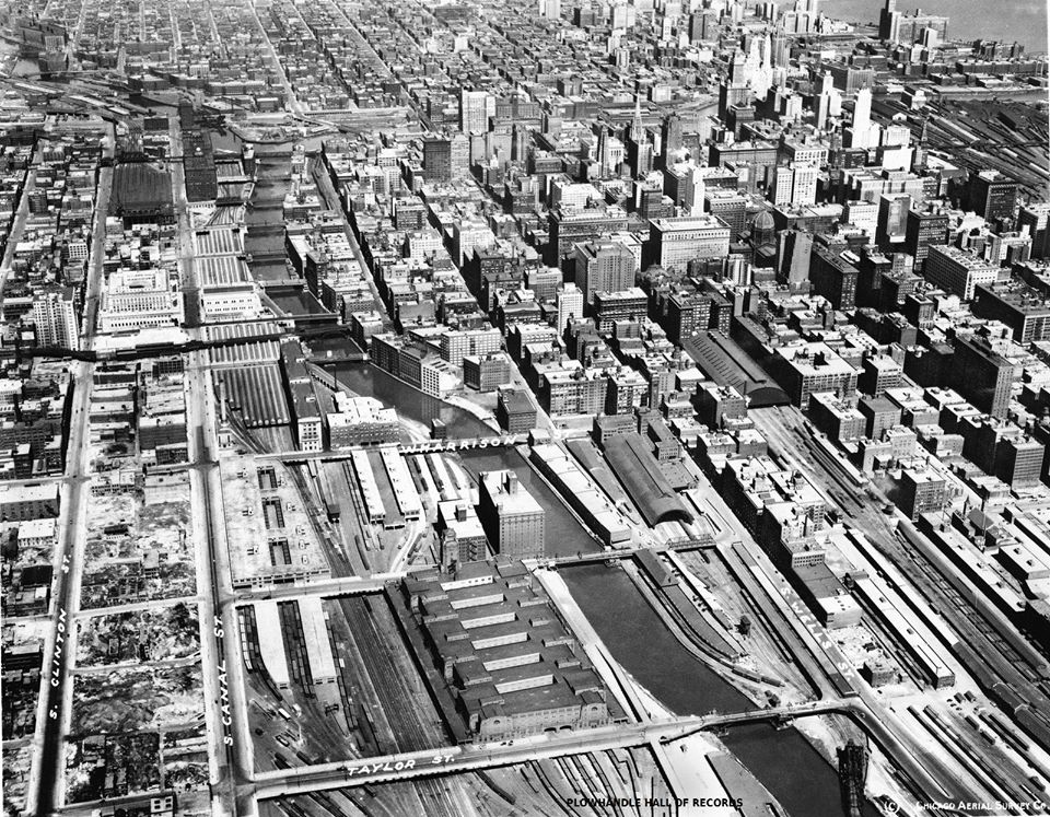
Dennis DeBruler shared with the comment: "This view shows some of the freight houses that used to be between Grand Central Station (note the clock tower on the right) and the river. It also shows that some big boats came down the South Branch and the Harrison Street Bridge in the raised position because of that big boat."
Thomas Karsten: The white building behind the clock tower is 175 w. Jackson and the faint outline behind is 208 s. La Salle. Looks like it’s after this section of the river was straightened.

Dennis DeBruler commented on MWRD's first post
The building along the right was one of the B&O freight houses.
https://www.loc.gov/resource/g4104cm.g01790190601S/?sp=80

Jeff Nichols posted
Chicago River, view from Taylor, 1909. Pitt.
Victor StLawrence: Looking north. The warehouse on the left is where the newer post office is.
Marshall Field warehouse on the left.
Paul Jevert shared
[Note the trainshed and tower of Grand Central Station on the right side of this photo. And of course the freight houses along the river.]

 Note the freight house between the Grand Central Station and the river in the right background.
Raymond Kunst posted via Dennis DeBruler

Since I'm learning how to use the LoC's collection of Sanborn Maps, I checked out the map to the north, 71. The GTW freight house is along the river and Pere Marquette has one sandwiched between the GTW freight house and the train shed of Grand Central Station.
https://www.loc.gov/resource/g4104cm.g01790190601S/?sp=72

I shared the MWRD post with another group, but Facebook won't give me a link to it. :-(

North is to the right.
Alice Niu posted

History's Mirror posted
[I'm not copying the description because it is an example of AI gone wrong. Basically, if a statement is not a platitude, it is wrong. The dredge is in the old channel, not the new one. And "Polk and Taylor Streets" implies an intersection, but they are parallel streets. The photo below shows that the photo was taken from Taylor and we are looking at Polk Street Bridge.
But it is a great photo of the freight houses and Polk Street Bridge.]
Franklin Campbell shared
Dennis DeBruler: The dredge is digging in the old channel, not creating the new one. But this is a terrific photo of Polk Street Bridge.

This photo confirms that the train shed that we see in the above photo was for the Grand Central Terminal. And because it includes the Pennsy freight house, I could confirm the streets as Taylor looking at Polk.
B&O C&O Grand Central, Chicago Terminal 1890-1971. posted via Dennis DeBruler
B&O Chicago Terminal, (Grand Central Station).
Lower left, old Pennsylvania Freight House - (1918-1974). 
323 Polk Street, Chgo.
Center of photo, Grand central and Train shed - (1890-1972) 
201 W. Harrison St. Chgo.
To the right was LaSalle Street Headhouse - (1903-1981). 
414 So. LaSalle St. Chgo.
[The date was probably c1924 because the new CUS is still being built. The tall building in the northwest quadrant of Polk Street and the river was the Marshal Field River Warehouse.]
Andrew Roth shared with the comment: "Forwarding this photo of Grand Central station and LaSalle Street Station when both station had large multi- track canopy roofs."

Thomas Manz commented on Andrew's share
Rand McNally view looking W from1893


Sunday, July 26, 2020

I-70 Viaduct and UP/(C&NW+CGW+MP) over Kansas River in Kansas City

1904 railroad: (Bridge Hunter) UP Kansas River Bridge #3
1907+1962+2020: (Bridge Hunter; Historic Bridges (1962)) Lewis and Clark Viaduct

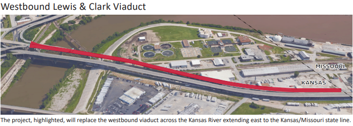
The Lewis and Clark Viaduct goes between Kansas City, KS, and Kansas City, MO. The railroad bridge is in Kansas City, KS.

The eastbound road bridge was built in 1907 as part of an intercity viaduct. A lower level was added in 1930. The parallel span opened in 1962. The old viaduct was repaired in 1963. The lower level has been converted for use by pedestrians and bikes. The 1962 was replaced in 2020.

KKFI 90.1 FM posted
Then-and-now: The Lewis and Clark Viaduct opened to the public in 1907 as a roadway bridge connecting Kansas City, Missouri with Kansas City, Kansas. Built to withstand flooding, the bridge featured a pedestrian walkway, lanes for wagon traffic, and streetcar tracks.

eBook via Bridge Hunter, Public Domain

Note the extensions that were added on top of the pier because the depth of the steel girders is much shallower than the old deck truss.
Iron Jim posted
Where the kansas meets the Missouri
Damian Joseph What bridge is this?!?
Dennis DeBruler Is this photo contemporary? The road was supposed to be open by Dec 31, 2019.
https://www.kctv5.com/.../article_b6f4d7c4-afcd-5011-8ce5...
Iron Jim Dennis DeBruler Picture is from Monday morning [July 13, 2020]
Dennis DeBruler I just determined that the flooding of 2019 caused delays.
http://kansastransportation.blogspot.com/.../weather...
Ben Stalvey Old versus new... Neat 4100 and 2250
Iron Jim Ben Stalvey There's a 999 hiding in the back, behind that man lift.
Dennis DeBruler The 1907 bridge on the right (eastbound lanes) is not being replaced, Just the 1962 westbound bridge. A deck truss is being replaced with steel and concrete (depending on the length of the span) girders.

Dennis DeBruler commented on Damian's comment on Iron's post
It finally occurred to me that he met the mouth of the Kansas River.
https://www.google.com/.../@39.1134458,-94.../data=!3m1!1e3


The 1962 bridge is being replaced now, but replacement of the 1907 bridge will be in the future. They used "energetic felling" to remove the old trusses. "The bridge will have both concrete and steel beam girders, depending on the span....More than 55,000 feet of steel pile and 2,100 feet of 72-inch diameter drilled shafts comprise the foundation." In Aug 2018 it was expected to be finished in Spring 2020. [acppubs] A Feb 2019 article claims the construction was on schedule to open by the end of the year. The plan was two years and $65 million. [KSHB] But the floods in 2019 has put them behind schedule.

LCV-handout

KDOT flood delays

KDOT design

Given the square edges of the openings, they are evidently repairing this pier. I wonder how they dealt with the rusted rebar.
Street View

Street View

This 2016 photo of the south portal of the RR bridges catches the old deck truss of the westbound I-70 bridge.
John Marvig via Bridge Hunter, Sep 2016

1908 Postcard via Bridge Hunter
[Note the toll booth.]

Five photos from an AmericanBridge web page:
1

2

3

4

5

Bridge Hunter comment

Bridges Now and Then posted
"The Missouri Pacific Railroad Bridge over the Kansas River during the 1903 flood. The people in the image are standing at the footing of the Union Pacific Railroad Bridge, which was washed away during the flood." (KC History)
[UP must have done a significant reroute through town since 1903.]

Comments on the above post

Sunday, May 24, 2020

CGW Chicago Freight House and Tripoli Factory

(Satellite, as with most freight houses in Chicago, it is long gone)


Larry Retzl posted
Photo of Grand Central Station .
Thomas White I took one from about the same angle - 45th floor of the Board of Trade building...takes hanging out the open window.
Dennis DeBruler commented on Larry's post
And of some freight houses. I tried boosting the shadows and reducing the highlights.

1953 Englewood Quadrangle @ 1:24,000

Satellite

Street View

I posted the above images with the comment:
The first photo was posted by Larry Retzl. The second one is after I brightened the shadows and darkened the highlights. Not only does this photo put the headhouse, tower and train shed of Grand Central Station in context, it shows where the Chicago Great Western Freight House was. But what is the tall building on the other side of the river? Beyond that building was Pennsy's freight house. Chicago & Alton had a freight house out-of-frame to the right. (It still stands, https://www.google.com/maps/@41.8750194,-87.6355206,186a,35y,270h,44.97t/data=!3m1!1e3) Was the building north of Polk Street another C&A facility?I noticed the two barges parked by the former location of the CGW freight house. So after 70 years, the Grand Central Station land will be more than a weed field.
Rick La Fever That tall building is the Union Station Power House, I think.
That might explain the barges too. They brought in coal for the boilers.
Timothy Leppert That powerhouse was once owned by Thomas Edison and the Steam it produced drove steam engines in the basement of Union Station that ran large electric generators. Last time I was down there they were still there.
Dennis DeBruler commented on Rick's comment on Dennis' post
The barges are contemporary. It is not unusual for a contractor to bring in barges for a riverside development, especially to hold a crane. In fact, it looks like they are building a crane on the northern one. Sometimes the crane is already assembled when they bring it in.
https://industrialscenery.blogspot.com/.../manitowoc-mlc...

Dennis DeBruler commented on his post
I meant the building directly across the river. Although the power house running generators in the basement of Union Station is interesting. I always assumed the pipes you see along Taylor Street Bridge in old photos was for steam heating in Union Station. I also assumed that Pennsy used the steam in their coach yard since the power plant is so far south of Union Station. I know CB&Q also had a power plant down around 14th Place and Canal. And of course they also had big coach yards down there. The Union Station power house is still standing, but I saw an article that Amtrak wants to tear it down in favor of a parking lot.
https://www.google.com/.../data=!3m1!1e3!4m5!3m4...
Tom Skowronski One of them was 310 W. Polk, home of the "Play Tripoli" sign painted on the elevator penthouse. I was in there in the mid 70s, and they actually manufactured the Tripoli game there. Those towers were torn down in the late 80s-early 90 as part of the new Main Post Office project.
Dennis DeBruler So the buildings were effectively high-rise factories.

Dennis DeBruler commented on his post
The shadows indicate not only were the skinny rectangle and trapezoid on the topo map tall, they both had towers.
https://clearinghouse.isgs.illinois.edu/.../0bwq08049.jpg

Patrick McNamara commented on Dennis' post
Geez, Dennis - gazing at SHADOWS from 1200 feet ? Here's a photo from the early 20s with your mystery buildings a bit more visible.
Dennis DeBruler And it has a nice view of Grand Central and LaSalle Stations and several freight houses. Wolf Point looks naked without the Merchandise Mart.
William Shapotkin Looks like the Post Office (betw Van Buren and Harrison) has not yet been built. GREAT PHOTO!
Patrick McNamara William Shapotkin = But that part that is in the photo is still there !
William Shapotkin The photo was probably taken 1925-28. The present-day Union Station opened May 16, 1925, but construction of the Mart (construction began August 16, 1928) has not yet started.

Dennis DeBruler commented on his post
The first phase of the old post office was built in 1922. That building became the east side of the 1934 building. Unfortunately, the City of Chicago has broken my reference:
Photo from Page 14 of https://www.chicago.gov/.../Old_Chicago_Main_Post_Office...
Mark Kocol Dennis DeBruler - is this today's view? https://goo.gl/maps/kPhCxAvwY3LXzpTWA
Dennis DeBruler Mark Kocol Yes
https://www.google.com/maps/@41.8778113,-87.6368263,257a,35y,210.46h,44.94t/data=!3m1!1e3