These are notes that I am writing to help me learn our industrial history. They are my best understanding, but that does not mean they are a correct understanding.
The NS Bridge is in the foreground, and the CN bridge is in the background. To the left of the light post in the distant background is the Monroe Power Plant.
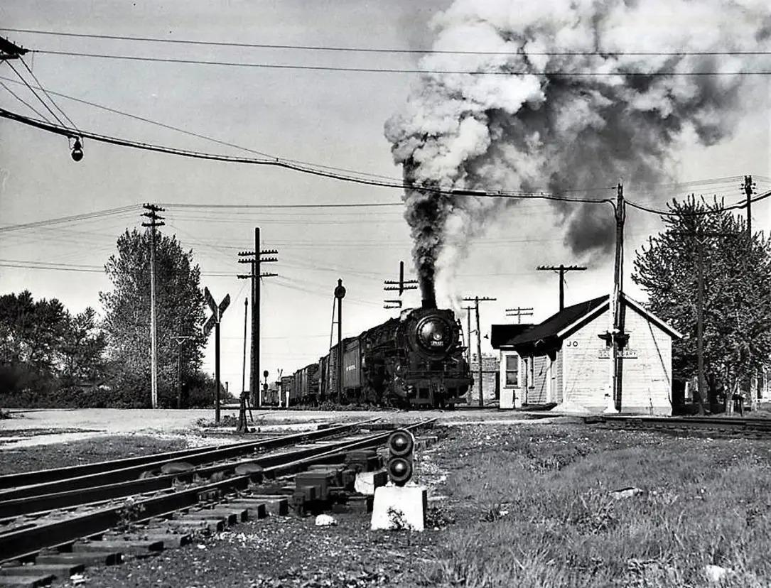
Bob Poortinga commented on John Starzyk's post below South Gary crossing where the NKP crossed the NYC Joliet Branch. Photo courtesy of Wayne Hudak. I believe the photo is looking east with a westbound on the Joliet Branch.
John Starzyk posted the comment: "I’d love to a see a picture of where the New York central tracks crossed the Nickel Plate RR in Gary, In."
John Starzyk: It was just a block or two east of Broadway and north of 41st Avenue.
Bob Lalich: John Starzyk - the MC Joliet Branch crossed the NKP west of Broadway and north of 41st Ave. The location was called South Gary. It was a very simple crossing - one track for each RR.
Jason Nanista: If this is looking east, then the crossbucks are for the crossing with Adams Street?
John Starzyk: Jason Nanista that’s what I’m thinking
John Starzyk commented on his post Here’s an early map of some of the Fr in gary
I had noticed that the Trenton Channel Power Plant received its coal via railroad instead of Laker even though DTE built a coal dock in Superior, WI, to ship Powder River Basin coal to its plants along the Detroit River. At first, I assumed it was because the big ships had to use the fat part of the Detroit River on the east side of Grosse Ile. But when I used street view on the free bridge to get a view of the power plant, I noticed that the bridge had a swing span. More on the navigation channel after the topo maps below.
The 1913 toll bridge provides access to the north side of the Grosse Ile. One advantage of a toll bridge is that they can afford to maintain a website.
Historic Grosse Ile Toll Bridge over the Trenton Channel of the Detroit River between Detroit and the northern end of Grosse Ile, Michigan. The bridge was constructed between 1912 and 1913 for the Grosse Ile Bridge Company. It is a five-span polygonal Warren through truss swing bridge.
The bridge was hit by lake freighters in 1965 and 1992 requiring major repairs.
"Over the years, the GIBC has completely renovated, and significantly expanded, the Toll Bridge. The GIBC has also had to perform major repairs to the Toll Bridge as a result of a large section of the span being hit by lake freighters in 1965 and 1992. Despite the magnitude of the damage caused during the September 1992 accident when the H. Lee White self-unloading bulk freighter knocked a section of the span into the river, the Toll Bridge was back in full operation by January of 1993. The GIBC replaced the bridge deck in 1986 and built a new central swing bearing in 1994. During 2005, the GIBC opened a toll plaza in Riverview which greatly increased the traffic flow capacity of the span." [GIBC-history]
HistoricBridges-toll explains why a riveted truss is rare in Michigan.
Digitally Zoomed
The 1931 free bridge provides access to the south side of the Grosse Ile. "Built 1932 on piers of Michigan Central rail bridge; rehabilitated 1980" [BridgeHunter-free] HistoricBridges-free has determined that the bridge opened on Sep 3, 1931 instead of 1932.
1932 Grosse Ile Parkway Bridge over the Trenton Channel of the Detroit River between Detroit and Grosse Ile, Michigan. The bridge is also known as the Grosse Ile Free Bridge and the Wayne County Bridge.
The bridge is a Pratt through truss swing bridge.
C Hanchey Photo via BridgeHunter-free, License: Creative Commons Attribution-NonCommercial (CC BY-NC)
Jonathan Konopka posted This is the Grosse Ile Free Bridge in Grosse Ile, MI. It is a swing bridge that was built in 1931 and carries Grosse Ile Parkway over the Trenton Channel of the Detroit River.
Photo via HistoricBridges-free "The previous bridge at this location was also a railroad truss bridge, but it was a iron Post truss. Even back when this previous bridge was replaced, it would have been an uncommon bridge as Post truss bridges were never very popular." Maddox Attales posted I see that the Grosse Ile Parkway Bridge (better known as the "free" bridge) is again closed for a long stretch [in Sep 2025]. I lived on the Island briefly during closures & don't miss that. The original bridge was a train trestle(1873) that was converted to road in 1931. I found this cool old photo.
"Intact but closed to all traffic in May 2020 for repairs" [Bridge Hunter Index] The company that owns the toll bridge must love this because the repairs took a while because it was still closed in Jan 2021. I hope these repairs include stabilizing the sinking pier that HistoricBridges-free describes. The bridge was also closed in 2007 for major repairs.
The free bridge was built before 1906, but blogspot won't let me put a "<" in the title because it doesn't know that it should convert it to "<".
1906 Wyandotte Quad @ 1:62,500
As expected, NYC/Michigan Central quit servicing Grosse Ils after the 1931 road bridge was opened. And the Trenton Channel Power Plant has been built.
1936 Rockwood and Wyandotte Quads @ 1:31,680
Taking a closer look at a satellite map, the east side of the river is basically a wet sandbar. So it is probably easier for USACE to maintain a navigation channel in the west side of the river. Or do they maintain a downbound channel on the west side and an upbound channel on the east side? This satellite image is why I wonder if they maintain two one-way channels because there is clearly a channel on the east side of Grosse Ile. No, it is not one-way travel. As detailed below, the 1992 allision with the toll bridge was downbound, whereas the 1965 allision was upbound.
I know that the west channel accommodates downbound traffic because of this photo of the 1974 705' M/V H. Lee White approaching the toll bridge. I know it is going downbound because the McLouth Steel Works is on the right side of the photo.
It is significant that the swing span in the above photo is wide open because that Laker allided with the bridge on Sep 6, 1992.
gibc-1992 Despite the magnitude of the damage caused during the September 1992 accident when the H. Lee White self-unloading bulk freighter knocked a section of the span into the river, the Toll Bridge was back in full operation by January of 1993.
The swing span is 305' long and provides two 125' "draws." The freighter was 78' wide. Two tugboats were helping to guide the freighter through the bridge. The span was open, BUT it was not opened soon enough. The bridge should have opened when signaled by the time the freighter was within 3000' of the bridge. But there were still cars spotted on the span when the freighter reached the point-of-no-return at 2000'. So the captain slammed it into reverse. I saw a ship go into emergency reverse for the Lake Street Bridge on the Chicago River. The ship turned dramatically. In other words, you loose directional control of the ship when you are in panic reverse. When the captain dropped the 13,000 pound bow anchor, he lost even more control of the direction of the ship. He almost got it stopped in time, "but its bow tapped the stationary span on the east side of the bridge. Because of the huge momentum of a ship laden with 67 million pounds of iron ore, this slight tap was enough to knock the entire 180-foot span into the water." The bridge was at fault because they did not open the draw soon enough and the captain was at fault because he should have dropped the anchor when he reversed the propeller. [caselaw]
During the 1965 allision by John T. Hutchinson, cars were still on the span that got hit. But no one was seriously hurt because people saw that the freighter was coming at them and got out of their cars and ran to safety.
Photo via gibc-1965 On August 6, 1965 the John T. Hutchinson, upbound in the Trenton Channel of the Detroit River after having unloaded taconite ore at McLouth Steel, lost steering control and struck a stationary section of the Toll Bridge. This caused the bridge section and two cars to drop into the river. Fortunately no one was seriously hurt, but the bridge was closed for several months. The Hutchinson sailed to AmShip's South Chicago yard for repairs.
I used street view to confirm that they now stop traffic before the cars get on the spans when a ship is approaching. This makes the wait time for the cars longer, but it improves the safety.
Nina Alambair posted thee photos with the comment: "Anyone remember this ? On August 6, 1965 the freighter John T. Hutchinson, up bound in the Trenton Channel of the Detroit River after having unloaded taconite ore at McLouth Steel, lost steering control and struck a stationary section of the Grosse Ile Toll Bridge. This caused the bridge section and two cars to drop into the river. Fortunately no one was seriously hurt, but the bridge was closed for several months."
Gary Dubrul: That’s the cargo the Edmond Fitzgerald was carrying 😳
Jeffrey Zanon: There was another collision in '92 or '93. I had just moved to the Island. Stop into Loyde's on Macomb. They have a picture on the wall behind the Bar.
Ted Kovoch: The bridge was hit by another freighter in 1991 knocking the east section of the bridge off its piers and into the river. I contacted the owner and gave him my business card and told him the company I worked for has the capability to repair his bridge. He put us on the bid list and we won the contract to replace the damaged section. A great crew of Ironworkers from Local 25 Detroit removed the damaged span from the river and erected a new span on a barge and floated it up river and sat it and the old piers. They completed this project in less than six months. The company that me and the Ironworkers and Operating Engineers were working for was JS Alberici a top-notch construction company out of St. Louis Missouri.
Kyle Kearney: That's my uncle's truck that's on the bridge. We have those photos hung up in our house.
1 of 7 photos posted by Andrew Dean Detroit [The free bridge is framed by the smokestacks of the Trenton Power Plant, which is soon to be torn down.]
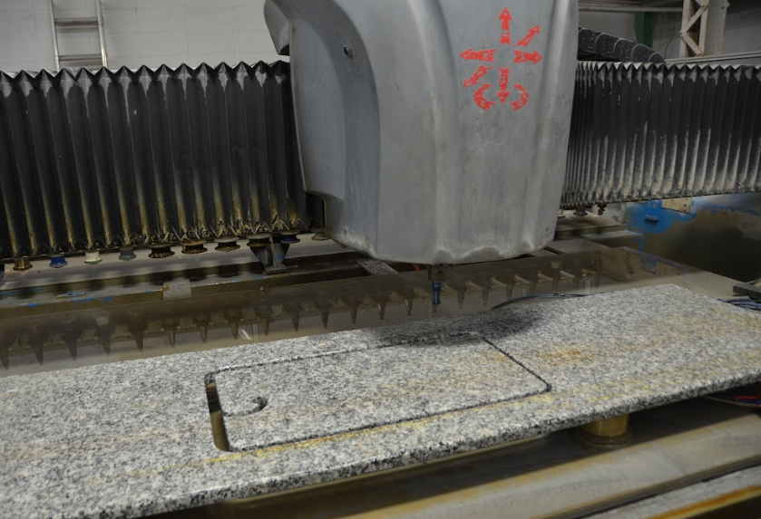
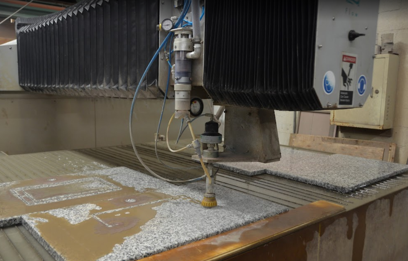
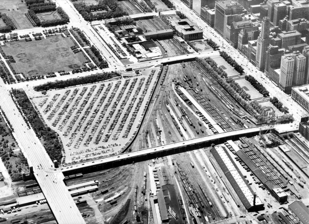
This facility is just west of Dryer in Illinois. There is no quarry here. But cutting and polishing stone is an important part of granite and marble consumption.
HalstEd Pazdzior posted EJE 659 heads east on the Matteson Sub. L514 is the symbol. 4/21/22 [It is significant that this locomotive still has an EJ&E livery because CN bought the railroad several years ago. And it has a caboose right next to the locomotive. So it must have been switching some industry.] Joseph Tuch Santucci: That granite facility there is where the Vietnam memorial wall was produced.
The CN/EJ&E goes along the south side of the plant. The railroad that went along the north side was NYC's Michigan Central. That route was called the Joliet Cutoff.
Actually, it looks like the ship was parked in a slip off the Chicago River.
1901 Chicago Quadrangle @ 1:62,500
History's Mirror posted [The only info in the AI-generated platitudes is that this is in the 1880s from the Rush Street Bridge.] Lloyd Scott Hardin shared
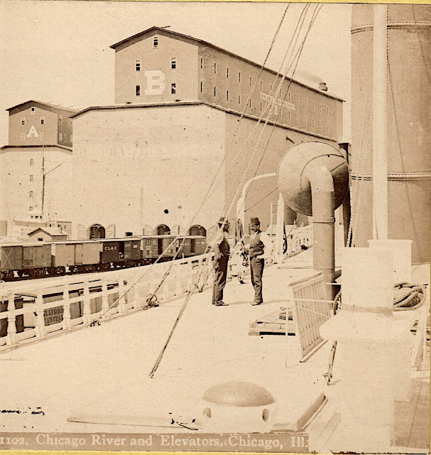
Dennis DeBruler: Since those two grain elevators were in the Illinois Central Railyard, we are look East towards the mouth of the river.
This interesting, early woodcut engraving arrived today. It appeared in the July 1877 edition of Frank Leslie's Popular Monthly Magazine as part of an article titled "The Great Grain Movement," which detailed the booming grain industry in the US.
The woodcut depicts the new elevators constructed in the outer harbor after the fire of 1871. The details are quite accurate, suggesting that the woodcut was created based on an original photograph.
An excellent depiction of a big three-masted grain carrier appears as well as early passenger and package freight steamer and a harbor tug.
This woodcut is quite large and very finely detailed. Feel free to click on the images and zoom for details.
Brendon Baillod shared Dennis DeBruler shared An image from 1875. This is looking south along Slip B between Illinois Central's two grain elevators along the Chicago River. The Interstate Exposition Building is in the background just to the right of the center line. Black smoke was still considered a sign of prosperity, so the artist generously added smoke. I've read that grain was one of three commodities that made Chicago and the railroads. (The other two were lumber and meat.) What struck me was the transition from sails to steam. First of all, the steam-powered ship still has a mast. Secondly, both tugboats are steam powered. Tugboats were to water transport as switchers were to railroads --- they handled the on-demand local movements. Just as the transition from steam to diesel started with the switchers, I see that the transition from sail to steam started with the tugboats.
I added Michigan Central to the title and labels because of this post.
Brendon Baillod posted four images with the comment:
This sharp, early stereoview card arrived today. It is a pre-fire Chicago view made by the notable Chicago stereoview maker John Carbutt.
The view is stated to show Buckingham's Elevator A, which was destroyed in the Chicago fire. It was later rebuilt as the Central Elevator. Based on the maker, the style of card and the the elevator shown, I'd date it about 1869. Another original copy of this card is known to exist at the New York Public Library collection.
[The description goes on to discuss the freighter.]
3 Paul Petraitis posted Our original river/rail connection, 1858, probably a Hesler photo. Paul PetraitisOriginal in the Chicago History Museum collections, a gift of Mrs. Lizzie Moulton Kneeland. Richard Fiedler shared Rick PowellThe Buckingham family owned many of the grain elevators at the north end of the IC tracks. Namesake of the fountain and also the tiny town in Kankakee County.
4 David Daruszka commented on Richard's share Image of the IC holdings in the lakefront and river. There was quite a panoply of railroads using IC's first Central Station (#2 in the image). The CB&Q had their first office building next to the station.
5 Thomas Manz commented on Richard's share What was the last business or industry north of Randolph Street to have a rail connection?
Bob Hendricks posted April 10, 1937 – Fire breaks out at 4:00 a.m. at the South Shore depot that sits alongside the Illinois Central Railroad station just east of Randolph Street. It doesn’t take long before “flames burst through the roof of the structure, lighting up Michigan avenue in the vicinity of the public library, and attracting hundreds of motorists and loopgoers to the scene.” [Chicago Daily Tribune, April 11, 1937] The fire brings a large response from the Chicago Fire Department as fire fighters keep their distance battling the 2-11 fire while crowds on the Randolph Street viaduct watch the heroics. The twelve-year-old structure was first used by the Illinois Central but was turned over to the South Shore in 1931. This'll be the second time a fire guts the depot. In a May, 1934 fire, five fire fighters were injured. In the above photo the station stands just to the right of the peristyle, which was torn down in February, 1953. Today this is the northwest corner of Millennium Park.
6 Glen Miller posted 1906 postcard of the Illinois Central's yard. The Michigan Central Railroad, a subsidiary of the New York Central, shared track rights with the Illinois Central. The Michigan Central also shared the IC's Central Station in Chicago as well. A switcher locomotive sneaking behind the freight cars, lower right. Glen MillerVintage Railroad Postcards David M Laz also posted David Daruszka commented on a posting Markham Yard in Harvey wasn't built until 1926. There were yards at Wildwood, Fordham and the main yards on the lakefront. Here's a postcard image of downtown. Jim Arvites posted Postcard view of the Illinois Central yard in downtown Chicago at Pleasure Craft Harbor and Randolph Street circa 1905. Note the Michigan Central passenger cars. The Michigan Central, a New York Central subsidary, used the IC's Central Station for its Chicago - Detroit passenger service until the late 1950's. David DaruszkaDavid and 3 others manage the membership, moderators, settings, and posts for Chicago Railroad Historians.Other railroads that used the station prior to 1871 were the Chicago & Alton Railroad, the Baltimore and Ohio Railroad, The Galena & Chicago Union and the Cleveland, Cincinnati, Chicago & St. Louis Railway from 1886 to 1893. At one time, and for years, through passenger trains were run between Chicago and Dubuque, Iowa. These trains ran between Chicago and Freeport, Il over the Galena & Chicago Union, and between Freeport and Dubuque over the Illinois Central. Two separate trains ran out of both Great Central Station and G&CU’s Kinzie Street Station. The two trains were combined at Oak Park as one train. On the return the train was split and each section ran to the respective stations.
17:21 video @ 0:18 They original were built from 1855-56. the bigger ones in most of the photos in these notes were built after the 1871 fire.
Christie Pasieka posted three images with the comment:
I have been sorting stereoscopic photos. I found a mix of Illinois. Finding photos like these give us all a look back to the rush to build and grow. In reading you learn of the number of boats and cargo that came into Peru, but photos are lacking. The ones here does give us the boat designs along with a rush of boats and men in a hurry. Below is the mouth of the Chicago River from Rush St, the photos had several dates, the earliest was 1865.
The second photo is year 1895, at the grain elevators in Chicago. The boat is the great whaleback ship
(A whaleback was a type of cargo steamship of unusual design, with a hull that continuously curved above the waterline from vertical to horizontal. When fully loaded, only the rounded portion of the hull (the "whaleback" proper) could be seen above the waterline. With sides curved in towards the ends, it had a spoon bow and a very convex upper deck. It was formerly used on the Great Lakes of Canada and the United States, notably for carrying grain or ore.