(
Bridge Hunter, Bridge;
Bridge Hunter, Tunnel; no Historic Bridges; 3
D Satellite, 154+ photos)
This HAER record is for the nearby Snowden Bridge. I include it because these two bridges have a similar design and the HAER includes several interior shots of the lift machinery.
Unfortunately, this flooded river soon joins the Missouri River so this flood will help prolong the flooding of the Missouri River. Because of the proximity of this bridge to the Missouri River, I have added the "wwMou" label.
 |
Robert Kjelland shared
Chris Marcie Cottrell Why would there be an enormous lift bridge? The Yellowstone is not a navigable river. That looks more like the Missouri downstream of Gavin’s Point dam.
Robert Kjelland Chris Marcie Cottrell when this bridge was built the Yellowstone was classified as a navigable river that not long before saw paddle wheelers, including one that returned Custer’s horse from the Little Bighorn to Bismarck. The Soo Line was forced to put a swing bridge over the Red River between North Dakota and Minnesota for the same reason. It too was never used.
Chalk-a-Lot Dreams & Things posted
Please pray for the Fairview area folks being flooded by the river!
Sheila Eggum Fink Holy Crap!!! I know that river floods, but I haven’’t seen it like that!
[There are more comments about this being the worse they have seen.] |
A view of the bridge with a more typical river level.
 |
| Flickr Photo by The Goat, License: Creative Commons Attribution-NonCommercial-ShareAlike (CC BY-NC-SA) |
This Flickr photo shows the different high water marks on the pier. The current flood level is near the top of the ice-breaking slope. That makes it higher than any of the previous watermarks on the pier.
Treasure State Lifestyles Montana
posted five photos with the comment:
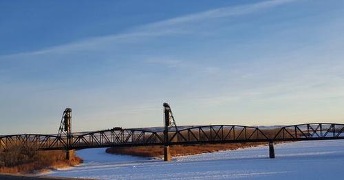
The Fairview Lift Bridge constructed by Gerrick & Gerrick stretches 1,320 feet across the Yellowstone River. In its earlier days, the Fairview Lift Bridge not only accommodated rail traffic, but also vehicular traffic. Planking was placed between and outside the rails to accommodate automobiles.
The Snowden Lift Bridge crossing the Missouri River 10 miles north of Fairview is a twin to the Fairview Lift Bridge. It, like the Fairview Lift Bridge, was constructed as part of the Montana Eastern Railway.
At the time construction of the two bridges began in 1912, federal law required an 80-ft. height clearance from the average water level on navigable waters. Being that both the Yellowstone and Missouri Rivers were navigable, both bridges were designed to accommodate the law.
The design of this style of drawbridge is distinct from others in that an entire section is uniformly lifted from each end. The nearly 300-ft. 'lift' section of each bridge weighs 1.4 million lbs. The 'lift' section consists of two 108-ft. towers that house the counterweights. Each counterweight connects to the section using 16 two-inch cables (eight cables per corner). Because the weight of the section was so well counterbalanced, a 3-cylinder kerosene engine is all that was required to raise and lower the section. Being that all river traffic ceased on both the Yellowstone and Missouri Rivers in 1913, the only time the 'lift' section on the Fairview Lift Bridge was raised was at the completion of construction in 1913 to test the lift mechanism's functionality. The last time the Snowden Lift Bridge's 'lift' section was raised was in 1935 to allow the passage of a freight boat carrying materials for the Fort Peck Dam.
While now closed to both rail and vehicular traffic, the Fairview Lift Bridge adjoins the only tunnel in North Dakota. The 1,458-foot long tunnel was built in 1912 and 1913. Most of the digging was done by hand, although horse and mule-drawn scrapers and blasting powder were used in building the approaches.
In 1991, the state began a survey of historic bridges. The Fairview Lift Bridge was on the list of 127 found eligible for the National Register. It was among 30 chosen for nomination. According to Hufstetler, who submitted the nomination, the bridge qualifies both for its historical significance and its unique engineering. In 1997, the bridge was listed on the National Register of Historic Places. Being that both the Cartwright Tunnel and Fairview Lift Bridge remain structurally sound, the Fairview Chamber of Commerce has developed them into a walking trail.
 |
| 1 |
 |
| 2 |
 |
| 3 |
 |
| 4 |
 |
| 5 |
John Lloyd
posted three photos with the comment: "Fairview Lift Bridge across the Yellowstone River in North Dakota. Built in 1913. Opened just once in testing. The tunnel at the end of the bridge is the only tunnel in ND. It was in service until the mid-80s. I was visiting North Dakota earlier this summer and stopped here on the way to Theodore Roosevelt NP."
Ken Heitzenrater: Seasonal steam boat traffic in the spring took supplies to forts and outposts in this area. They primarily ran in the spring during high waters. The railroad killed the steamboat traffic and the truck killed the railroad.
 |
| 1 |
 |
| 2 |
 |
| 3 |
Note the bluff at the other end of the bridge. That is where the tunnel is.
The tunnel has a curve.
 |
| Flickr Photo by The Goat, License: Creative Commons Attribution-NonCommercial-ShareAlike (CC BY-NC-SA) |
 |
safe_image for The Fairview Lift Bridge
A railroad lift bridge that was only lifted once and became obsolete before construction was finished.
[The article has several more photos.]
Ken Heitzenrater: Fascinating that steamboats were able to travel as far north as Montana.
Eddie Adams: It's fate is simular to the turn bridge at Pierre SD that never seen river traffic. |
 |
Darel Maden posted
North Dakota SR 200 at the Yellowstone River
Stuart Foster: Not SR200. That's the RR bridge. |


No comments:
Post a Comment