Sunday, July 28, 2019

MJ and BRC over CB&Q

Satellite

MJ = Manufacturers' Junction Railway
BRC = Belt Railway Company of Chicago
CB&Q = Chicago, Burlington and Quincy

Forgotten Railways, Roads & Places posted
Immediately east of Cicero, IL, an abandoned transfer track from the #BNSF Racetrack. Image taken aboard a train. #abandonedrailway #urbex #history #chicago#illinois
Dennis DeBruler Looking south. The tracks still exist. But I can believe they have not been used recently.
https://www.google.com/.../@41.8451034,-87.../data=!3m1!1e3
Forgotten Railways, Roads, and Places That imagery is from 2017. I actually watched them tear up this track. It's not to say BNSF won't rebuild this section, but as of now the track is gone.
Dennis DeBruler Forgotten Railways, Roads, and Places A "stale" satellite image. Thanks for the update.
Dennis DeBruler That Unilever Best Foods building in the background used to be a very common architectural style in Chicago for industrial buildings.
https://industrialscenery.blogspot.com/.../continental...

In this topo map it is clear that Manufaturers' Junction used to have a connection to the east end of CB&Q's Clyde (Cicero) Yard. Since MJ connected to BRC, there were connections between CB&Q and BRC in three of the four possible quadrants.
Dennis DeBruler commented on a post
There used to be (1929 Englewood Quadrant) a lot of industry and spurs in that area. The upper-left corner was Western Electrics Hawthorne Works.
https://industrialscenery.blogspot.com/.../western...

Dennis DeBruler commented on a post
Some remnants of Manufacturers' Junction Railway, including the roundhouse, still exist in a satellite image. That railroad served the Hawthorne Works.
https://www.google.com/.../@41.8461157,-87.../data=!3m1!1e3
During a commuter trip into town on Oct 21, 2016, I took photos to the south as I went through this crossing.
20161021 6513


Given the power lines in the photo below, this derailment happened on the far end of the outside curved connector in the above photo.
David Milior posted
Oops! Looks like a severe run-in. Engineer slammed the jammer and the rear car weight popped the cars off the track. East hole, BNSF Cicero yard. This leads up to the Belt Railway of Chicago.
Joseph Teixeira: How do you know it was the engineer’s fault?
Keith Huff: Joseph Teixeira it was. He admitted to what he did. He had the signal to enter the main line but the switch operator did have the right line up. The engineer slammed the independent brakes on. These were mt cars are within 10 cars of the locomotives. The train was 9000 feet long. When they come off the Belt Railway of Chicago, there is a significant decline of about 2500 feet to the crossing. This has happened before. I work the Chicago division. The three covered hoppers were pulled over onto their trucks all at the same time. A Trainmaster had a video of it.
[This is an example of the "Swiss cheese" model of accidents. In this case the holes lined up in two slices. The first slice is that a turnout and signal disagreed. The second slice is that the engineer used his independent (locomotive) brake rather than the train (air) brake. One could argue that a 9,000' long train, which is way over a mile, is a third slice. Most junctions have interlocks so that the signals and turnouts can't disagree. Even junctions built in the 19th Century had interlocks. So a fourth slice would be a brain-dead junction.]

Here is a better view of the location of the above accident. The tower in the distant center background is the clock tower from the former Western Electric Hawthorne Works.
Street View, Oct 2024

Back to the commuter train ride through the junction.


Nick Hart posted
BNSF train S LACNSA didn't quite meet the requirements of the height restriction at the BRC bridge in Cicero. 40 cars suffered significant damage and the bridge also suffered structural damage. Cargo is littered on and around the tracks, ranging from paper towels to boxes of cereal. A WSOR grain train is tied down on the BRC main above and likely won't be going anywhere until the bridge is inspected. 02-14-21
Stan Stanovich: ...got word of it this morning John, train destined for Ashland Avenue!!!
[It is nice to see that at least BNSF and NS do a steel-wheel interchange of containers.]

Matt Hovey commented on Nick's post
Wasn't the first time, won't be the last. You see how much lower m4 m5 are at this angle

The are more photos in the comments on Matthew Linhart's post.
Walt Del Calle: This was a through train that normally runs on the Santa Fe.
[I had seen a comment that the crew was unfamiliar with this route. This explains why. It doesn't explain why there wasn't a pilot. But some Facebook comments indicate that the crew had paper work that would explain which tracks to use for double stacks. You would think if they were on a new route they would have been more diligent about reading their paperwork, not less.]

In the comments on this post the opinion is that if a crew gets orders to do something stupid, the crew should push back using a medium (e.g. radio) that will be recorded and if they are still told to do something stupid, they do something stupid. But I doubt if the crew pushed back in this case. If they knew there was a problem, then they would not have pulled 3/4 of a mile of train under the bridge.

Twisted Truckers posted three photos.
Justin Hughes shared
Ridge Abbott: Good to know the pins work .
1, cropped

2, cropped

3, cropped
Keith Huff: It is in our subdivision general notices not to have high wides go under this bridge. We are to take them down main 4 or 5. This was main 3. I was going west bound yesterday with my train and saw this train waiting at an opposing signal about noon. This location is BNSF Chicago subdivision and the bridge is the Belt Railway of Chicago. This is just east of Cicero Blvd. 3/4 mile of train went under and 64 containers destroyed.
Dylan Fadda: Keith Huff so, this would be a dispatching error?
Keith Huff: Dylan Fadda yes, but also the crew's as it is in the written directives not to go under the bridge with high cars. There is also a huge sign 1/4 mike away above the tracks saying this.
Kevin James Cox: Dylan Fadda whether you hit one or 25 the penalty is still the same.
Keith Huff: Terrence Owen about an half mile ahead is a large sign on a pedestrian bridge warning that high car trains not to use main1,2,3. Also, it is in our directive paperwork. The dispatcher is supposed to know and line the train for either main 4 or 5. The crew, if they did their job correctly, would of not took the signal that directed them straight ahead on main 3. They should call the dispatcher to line them for the correct track.
Pettigrew Arriel: I'm just glad the crew wasn't hurt. Not their fault, it's the dispatcher.
Timothy Leppert: Pettigrew Arriel no, the crews fault.
Timothy Leppert: The Belt owns the bridge. The BN lowered some of the tracks and put up warning signs, as well as put it in the Special Instructions. The Crew obviously missed those things.

Keith Huff commented on the third photo, cropped

Saturday, July 27, 2019

Aban/NS/N&W Cincinnati Junction Bridge over Scioto River near Portsmouth, OH

(Bridge Hunter, no Historic Bridges)
Historic Bridges has some of the bridges in Scioto County, but not this one.

Satellite

Abandoned by Sherman Cahal posted five photos with the comment:
These are photos of the former Norfolk & Western Railway Portsmouth Branch bridge over the Scioto River near Portsmouth, Ohio.
The crossing was originally built for the Cincinnati & Eastern Railway (C&E) that once extended between Cincinnati, Ohio and Portsmouth, partly operated today by the Cincinnati Eastern Railroad (CCET). At its western terminus, it connected with the Cincinnati, Lebanon, and Northern (CL&N) and the Pennsylvania Railroad Richmond Division (PRR), and to the Scioto Valley Railway at its eastern terminus.
The bridge has been out of service since 2001 when the N&W's successor, Norfolk Southern, placed a significant portion of the line out-of-service because of the route's sharp curves, steep grades, and a lack of customers.
More on the history of this fascinating railroad (along with plenty of photos) can be found at https://abandonedonline.net/.../cincinnati-eastern-railroad/
Bridges & Tunnels by Sherman Cahal shared with the comment: "Now set to become a rail trail!"
Maurice Hartz: Is the bridge at Portsmouth still in operation!
Bridges & Tunnels by Sherman Cahal: Maurice Hartz No, OOS for about 23 years. Its now owned by the state of Ohio. The bridge had weight and height restrictions, and sfter NS acquired Conrail trackage, it was easier to reroute to Columbus and then to Cincinnati.
1

2

3

4

5

(new window) Posted by Kevin Pike in Railroad Bridges Past and Present at 7/22/2019 0759.
"Norfolk Southern (ex N&W) inactive peavine line bridge crossing the Scioto River north of Portsmouth, Ohio. This line was taken out of service due to settlement issues with the bridge and the western approach."
Steven Ward Hard to believe that the mighty J class engines used to run about 100 MPH.
Kevin Pike Steven Ward still owned by NS between Portsmouth and Cincinnati, Ohio. It is leased on the west end from Cincinnati to just east of Peebles, Ohio to Cincinnati Eastern Terminal with light traffic and car storage. The washouts on the east end would have to fixed before anything could run on the half.
Steven Ward First of all, thank you for clearing that up for me on who owns that line. I heard it was sold off. Thank you for straightening that up for me. I saw trains parked on it in various spots. But wash outs? I didn't know there was any wash outs. Where at exactly? I heard the bridge shifted 5 feet.
Steven Ward NS got the former NYC main from Columbus, Springfield, Dayton, to Cincinnati line which at first ran a lot of trains on that line when Conrail was around. NS got that line in 97. Now sees maybe 13 trains per day. So NS may run trains up to Columbus then down to Cincinnati.


This bridge shows the importance of understanding a river's flood plain. Seven of the nine spans are over "dry land." But that was not enough because it looks like a washout of the embankment on the northwest side is part of the problem.
Screenshot at 3:59
Kevin Pike posted a couple of photos by Preston Whitt near Rushtown as comments. They show why railroads need to spend so much money on track maintenance. And the bridge suffers from shifting piers.
1

2

Thursday, July 25, 2019

1938 Bonneville Lock, Dam and Powerhouse on Columbia River

(USACE; Satellite, 222+ photos)

Columbia River System Overview

USACE Teacher's Guide

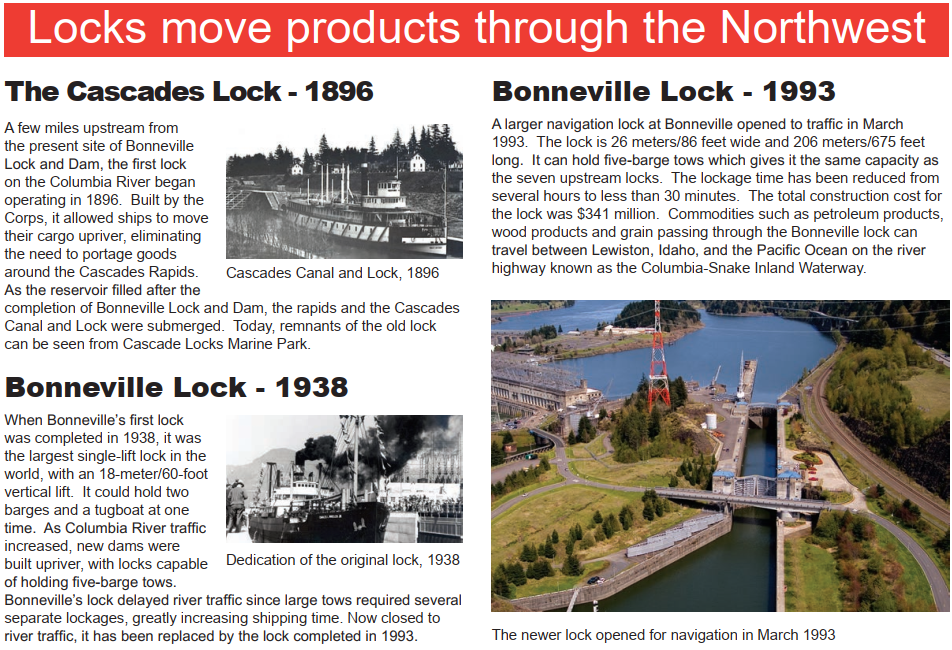
It has two locks and 2.5 fish ladders. But the guide wall of the new lock severely restricts the length of what can use the first lock. The first lock was part of the original 1938 construction. The larger lock was added in 1993 to match the size of the seven other locks on the 465 mile Columbia-Snake River Inland Waterway. A second powerhouse was added in 1981 on the north side. [USACE] The spillway is in the middle.
Satellite
The 1938 lock is not even used for recreational boats. It has been closed. Even the new lock is small by Midwest standards. Specifically, the width is two barges rather than the three-barge width that we have on the Upper Mississippi, Ohio and Illinois rivers.
Bonneville Lock and Dam National Historic Landmark Brochure

Jeffrey Hunt posted
Bonneville 1935
This is an amazing photograph from 1935 — the construction of Bonneville Dam. Just understanding the scale of it for that year is remarkable.
You can see that The Dalles is 45 miles east and Vancouver 45 miles downriver to the west, so Bonneville really sits right in the middle. Camas is less than 30 miles away, with Washougal much closer — close enough to feel connected along the river.
I remember riding through there as a small child, before sunrise, in my dad’s 1949 Chevrolet — cream, with red and black painted fenders — on the way to salmon fishing, sometimes at Hamilton Island or trout fishing up in Gifford Pinchot. I was barely tall enough to see out the window, watching the neon lights of North Bonneville flicker through the early-morning glass while my dad explained what kind of place it was: a resort town with hot springs, spas, dances, and people coming up from Portland for the night. I didn’t really understand it then, but I remember the feeling of it — and his sense of loss, explaining that the town would soon be gone.
You can see part of the old town in the lower right corner of the photo — that main road lined with businesses. It’s all gone now. The entire town was moved when the new dam went in. It’s strange how little has been written about what North Bonneville once looked like. If you have photos or links, please share them in the comments.
My dad, Mahlon Hunt, took pictures up there before they tore it down — I haven’t found them yet, but hopefully they still exist somewhere in the boxes, on old tapes or film.
Aerial photograph by Brubaker Aerial Surveys, 1935. Courtesy Oregon Historical Society Research Library.
Mike Kluth shared
1935 Bonneville aerial photo

Screenshot

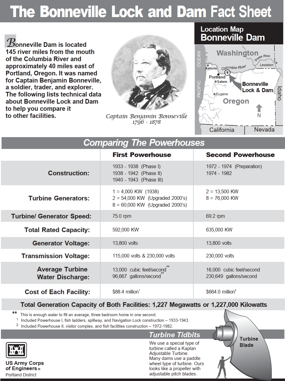
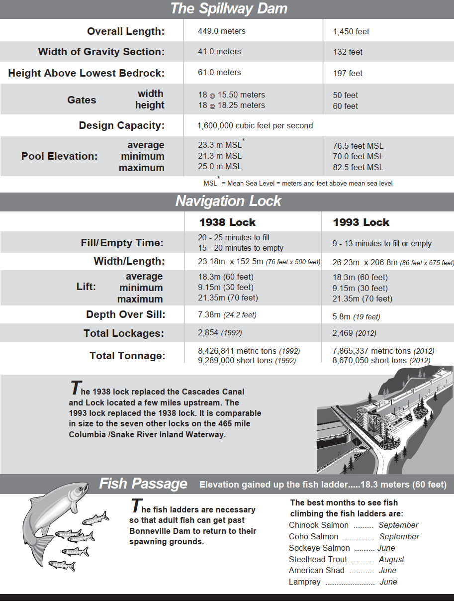
Downloaded Fact Sheet

Downloaded Fact Sheet

WaterwaysJournal via Advanced-American
[An emergency lock closure on Sep 5, 2019. The sill developed a crack, and it had to be torn out and replaced with a new one. It was expected to reopen Sept. 30, 2019. It actually reopened Sep 27. [opb] ]

Don Rod Chambers posted
In the 1950's, Portland District, US Army Corps of Engineers employed Gustanvus Michelson to create wonderful renderings of Portland District projects.  His work would show up in the contract drawings used for construction.  Some of the finest table work ever!

Portland District, US Army Corps of Engineers posted
We dug this cool photo up for you – it’s from the construction of Bonneville Dam in 1937.
That means today [Jun 11, 2022], this photo is 85 years old.
In recognition of the photo’s anniversary, as it were, we want to share the top 3 reasons we heart it so much:
1. So much to look at! The overalls on these men? Exquisite! Check out those hats! And … those cool-cat poses? So slay.
2. Just look at the size of that turbine. That is a - *checks measurements * - ginormous engineering masterpiece.
3. Our safety office would never let us take a photo like this today – OSHA rules and all, of course. It’s like an entire group simultaneously saying, “Look, ma – no hands! Or hard hats!”
James Torgeson shared
Building the Bonneville Dam between Washington and Oregon on the Columbia River.
Andy Michel posted
The best hydroelectric turbine group photo ever.
Richard Conserriere: Where is OSHA when you don't need them.

Teresa Labrousse posted 17 photos with the comment: "I have 1950 (number, not year) historic Bonneville Dam photos.  I can share the link to the album (on Amazon), if anyone is interested."
1

2

3

4

5

6

7

8

9

10

11

12

13

14

15

16

17

Teresa commented on his post
"Now" was 2014)

Matt Cavalier posted two images with the comment: "The generators atop the turbines inside Bonneville Dam along with a basic diagram of the hydroelectric plant."
1

2

Andy Michel posted two photos with the comment: "2007 Out with the old and in with the new..."
1

2

Teresa RL commented on Andy's post
Unit 10? That was my unit!

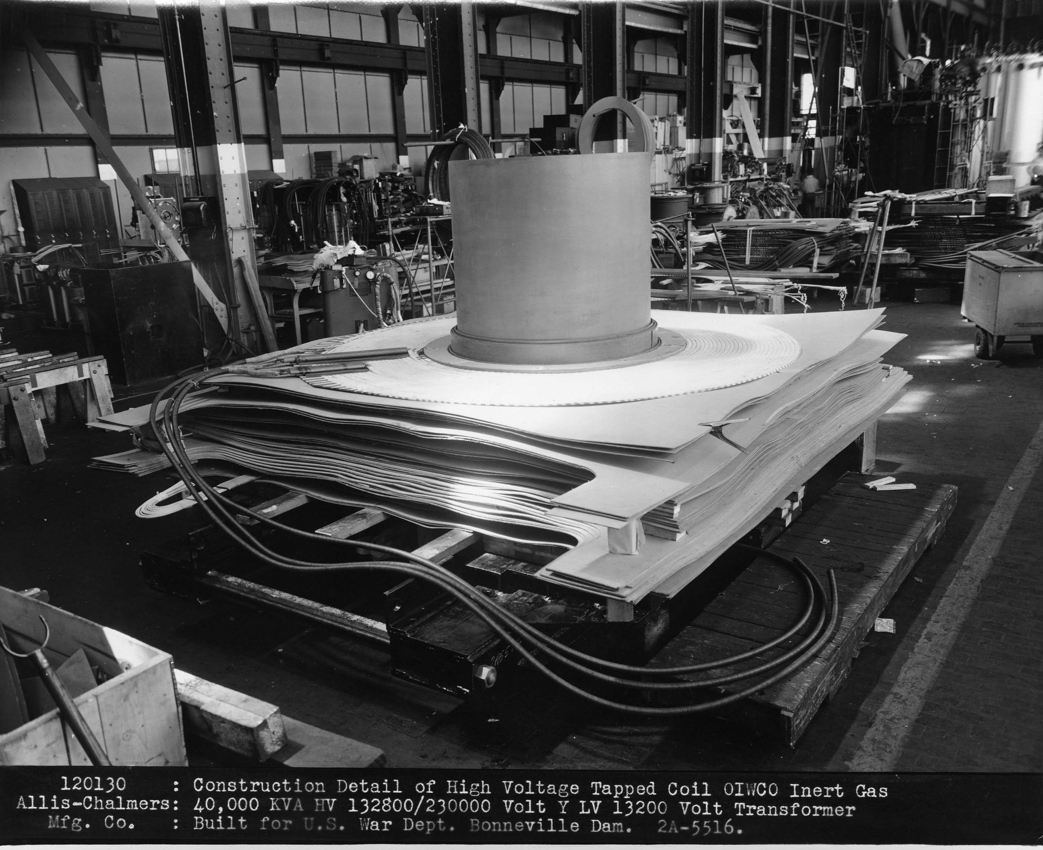
Teresa RL posted nine photos with the comment: "making xfrmrs for Bonneville Dam."
1

2

3

4

5

6

7

8

9

Andy Michel posted
Name it McNary Dam     Capital Journal    October 2nd, 1933
[About a decade later McNary did get recognized: McNary L&D.]