"Bear Mountain Bridge was the first vehicular river crossing between New York City and Albany. At the time it was built, it was also the longest suspension bridge in the world and the first suspended bridge to have a concrete deck." The name was changed to Purple Heart Veterans in 2018. Because the land in the area is granite, the piers and anchors were easy to build. However, the road to the east side was hard to build. 70% of the material had to be drilled and blasted. And care had to be exercised so that none of that material fell on the NYC tracks that were below the road. [hbhv, nysba has the same text so I don't know which is the true source of the material.]
The largest span is 1,632' and it is 2,258' long. It was rehabilitated in 1977. [Bridge Hunter]
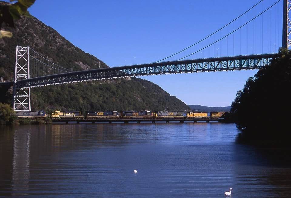
That is Bear Mountain in the background.
 |
| LC-HS503- 757 Below Bear Mountain bridge, Appalachian Trail, [New York] |

 |
| Adam Kuczynski posted Bear Mountain, New York. [Again, Bear Mountain is in the background of this photo. The train is on the CSX Popolopen Creek Bridge.] |
 |
| Ian Martin Flickr via Bridge Hunter-Popolopen Q434 shows up at Popolopen Creek under a cloud on an otherwise-sunny afternoon, led by CSX 7899 and 5306. |
The east shore has its own "mountain," which is called Anthony's Nose.
 |
| NYCroads (2004 photo by C.C. Slater.) "Construction of the bridge began in March 1923. The anchorages that hold the two main steel cables were dug manually out of solid rock at a rate of approximately eight feet per week. The west anchorage was dug 110 feet into the rock, and the east anchorage 90 feet into the rock. Once the anchorages were completed in October 1923, work began on the two 351-foot-tall towers. The towers were completed in April 1924....When it opened, the Bear Mountain Bridge had the longest main suspension span in the world, surpassing that of the Williamsburg Bridge by 32 feet. It held its title for only two years, giving it up to the Benjamin Franklin Bridge across the Delaware River in Philadelphia in 1926." |
 |
| River Rail Photo posted Take A Hike. Looking down from the top on Anthony's Nose in the Town of Cortlandt, New York on Friday, May 8, 2015 gives the "bird's eye view" of CSX 3013 (ES44AC-H) leading an intermodal train over Popolopen Creek in Fort Montgomery, New York. There are four bridges in pic (clockwise) - Popolopen Arch Bridge (Route 9W/road), Poplopen Suspension Bridge (pedestrian), Popolopen Creek Trestle (railroad) and the Bear Mountain Bridge (road). If you want to go for a hike here on a summer weekend, get up early - the limited parking fills up very fast. [My notes for the three Popolopen Creek bridges are here.] Full resolution pics and prints: https://www.riverrailphoto.com/freighttrains/eac08401 |
The photo below shows how tricky it was to build a road on the side of Anthony's Nose. Of the $6m spent on the bridge project, $2m was spent building this access road from Peekskill, NY. [asce]
[The deck is over 150' above the Hudson River.]
Because the state charter to build the bridge required that it be built in three years, the designers omitted covering the towers with masonry to save time. The locals thought the spindly steel towers were ugly. So the designers added an arch in the base of each tower to give it a tunnel-like appearance.
[The deck is over 150' above the Hudson River.]
 |
| Images of Rockland County, The Historical Society of Rockland County. "Bear Mountain Bridge." New York Heritage Digital Collections Accessed Apr 29, 2021. https://cdm16694.contentdm.oclc.org/digital/collection/hsrc/id/274 |
Because the state charter to build the bridge required that it be built in three years, the designers omitted covering the towers with masonry to save time. The locals thought the spindly steel towers were ugly. So the designers added an arch in the base of each tower to give it a tunnel-like appearance.
 |
| Street View |
The last suspension bridge I investigated, the Dresden Suspension Bridge, was the first time that I saw a bridge with a separate anchor and abutment. This bridge also has that design.
 |
| Street View |
The Toll House is also rather historic.
 |
| Street View |
Note the bridge in the background.
 |
| River Rail Photo posted Spirt Of Our Veterans. A pleasant surprise on the morning of Wednesday, July 21, 2021 brought CSX 1776 (ES44AC-H) in the lead of CSXT Q010-20 across Doodletown Bight near Iona Island, New York. This unit is one of 3 "Spirit" units painted by CSX to appreciate the work and committment of public service and emergency workers. The Bear Mountain Bridge crosses the Hudson River in the background. Flickr: |
 |
| Historic Bridges, another view |
 |
| Bridges Now and Then posted A photo taken during construction of New York's Bear Mountain Bridge, 1923. Listening to Grandmaster Flash's "The Message" on that radio, I imagine. (Fotograms) Theron Stratton: Had to be something pretty important, World Series maybe 🤔 Bridges Now and Then: Theron Stratton 1923 was the Yankees first series win, and it was against the NY Giants. That seems very possible! |
The foreground looks through the beams of the travelling gantry that lifted the steel for the deck truss from barges on the river.
 |
| Historic Bridges and hbhv-photos |
This was obviously taken from the top of the western tower while they were spinning the cables. In the right middle of the photo, I think we see a crane working on the east road that was carved out of the hillside.
 |
| hbhv-photos |
 |
| Bridges Now and Then posted New York's Bear Mountain Bridge, c. 1924. (HudsonValley) |
 |
| Dave Frieder commented on the above post Similar to Williamsburgh Bridge as the Side Spans are not suspended. |
 |
| Arminio Thomas commented on the above post |
 |
| Prussia Frank posted Bear Mountain Hudson Bridge NY [A suggestion by Facebook that was actually of interest.] |
I kept skipping this photo in my news feed until I finally noticed the suspension bridge and Bear Mountain in the background. This is the trestle that is in the foreground.
 |
| River Rail Photo posted The Real Last Run. Metropolitan Transportation Authority - MTA NYCT Subway Budd built R-32s 3879, 3878, 3929 and 3928 were part of a fleet that made its last revenue trip on January 9, 2022, ending 58 years of service on the system. These cars have had most of their mechanical components removed as well as their trucks, and are placed on FIC Equipment Corp flat cars to be scrapped. They are seen on CSX's River Sub on train Q434 on the afternoon of Wednesday, March 16, 2022 crossing Doodletown Bight near Iona Island, New York. More on the Farewell To The R-32s - https://www.riverrailphoto.com/r32farewell James Churchill: 58 years of service? Remember that the next time some bus or bus rapid transit"expert" tells you how much cheaper buses are and a dozen or so cars can be run by one operator and convey hundreds of passengers. [The graffiti was done after they left the NYCT property.] Neil Hourihan: Not destined to be artificial reefs? Adam Moreira: Stainless steel cars didn’t lend themselves well to be reefs as they just crumpled on the sea floor. The LAHT carbon steel cars have given rise to new ecosystems. |
Two of six photos posted by Curtis Tate with the comment: "The River Line, at Newburgh and Fort Montgomery, New York, September 2005."
 |
| a |
 |
| b |
 |
| Dave Blaze Rail Photography posted B741 At Bear Mountain I spent a couple nights in Newburgh for a getaway for my GFs birthday (at her request!) and managed to snag a few trains between other adventures, including finally making it to the Bear Mountain area for the first time. I know, I know...shameful that I'd never shot here at one of the most scenic, busy, and easily accessible mainlines in the Northeast despite only being 3 hrs from home! CSXT's River Sub (ex Conrail, Penn Central, New York Central, nee West Shore) dates from 1883 in this area and despite being a relative latecomer its mainline up the west bank of the Hudson has only grown in importance over the decades as traffic patterns have shifted. Today this line between northern New Jersey and the Albany area is by far the busiest north south route in the northeast, while conversely virtually the entirety of the West Shore's route to Buffalo along the south side of the Mohawk River has long been abandoned. CSXT train B741 (loaded ethanol from the Union Pacific in Proviso to Conrail's Oak Island yard) is at MP 41.5 as it crosses the thousand foot long curved trestle over Doodletown Bight approaching Iona Island behind a pair of more than quarter century old AC4400CWs. Rising beyond is the Bear Mountain Bridge. When it opened a century ago it was the longest suspension bridge in the world spanning 2255 ft across the Hudson River and 155 ft above the water line and with its towers reaching another 205 ft skyward! Originally a private toll road it has been property of the state of New York since 1940. The bridge has a couple railroad connections I found interesting as well. The original Hudson Highland Suspension Bridge as chartered in 1868 was originally planned to be a railroad bridge which if built would have been the farthest south rail crossing of the river. Despite raising capital, completing engineering work and even starting excavation of the anchor pits it never came to fruition and the second charter finally expired nearly a half century after the first. When the state then authorized the private highway bridge instead in 1922 one of the directors of the new company was E. Roland Harriman of the famous banking company who was the youngest son of legendary Union Pacific and Southern Pacific president E. H. Harriman who purchased the UP out of bankruptcy in 1898 and then acquired the SP in 1901. His leadership until is death in 1909 turned them into modern economic and corporate powerhouses that would be hugely influential throughout the 20th century leaving a legacy that carries on to railroading today....but I digress! Bear Mountain State Park Stony Point, New York Saturday February 24, 2024 |
 |
| safe_image for Governor Hochul Announces Kickoff of Bear Mountain Bridge Centennial Celebrations "The Bear Mountain Bridge was dedicated on November 26, 1924. It was a groundbreaking engineering achievement for its time, being the first vehicular bridge over the Hudson River south of Albany and the first suspension bridge with a concrete deck. For a brief period, it also held the title of "bridge with the longest suspended central span in the world." Many consider the innovations with the Bear Mountain Bridge to have spurred a boom in bridge building in New York State and the entire country in the years following." |
 |
| The Hudson Valley in pictures posted The Bear Mountain Bridge viewed from Fort Montgomery. [With the railroad and pedestrian bridges in the middle and foreground, respectively.] |
 |
| Facebook Reel [And we can also see the bridges over Popolopen Creek.] |
A drone video of the bridge, but I did not register to view it.