Saturday, July 26, 2025

CN Bridge over Anderson Creek at Fraser River near Boston Bar, BC

(Satellite)

Steven J. Brown posted
Twenty-three years ago today:
Rock Mountaineer Railtours on the Canadian National along the Fraser River at Boston Bar, British Columbia - July 22, 2002

Street View, Jul 2023

 Daniel Charbonneau Globe-Trotteur, May 2019

Frank Keller Photography posted
A CN intermodal train curves across the bridge at Boston Bar. In the background is the CP. During my visit in 6.89 each railroad ran trains on their own track. Today I understand they use CP for one direction and CN for the other. I would like to get back up to the Fraser River again someday. 
Clark Castle: CP was thru first so they got the grades. CN came later and had to settle for the less easy route. I have been thru here on the Canadian when CP was still running the service.


1930+1998 MT-13 Lewis and Clark Bridge over Missouri River near Wolf Point, MT

(Archived Bridge Hunter; Bridge Hunter; no Historic Bridges; John Weeks III; HAERSatellite)

Street View, Nov 2024

Bridges Now and Then posted
"Northeast view, completed Wolf Point Bridge (1930) - Wolf Point Bridge, Spanning Missouri River at State Highway 13, Wolf Point, Roosevelt County, MT". (Library of Congress)
Hunt Agnes: OMG!! It took me a few minutes of admiring the magnificent structure to realize that there are two lunatics 🕺🕺standing on the top of it!!!

"The Wolf Point Bridge is the finest remaining example of a Pennsylvania through truss bridge in Montapa. Completed in 1930, the four-span bridge is the most massive in the state and retains the longest through truss span in Montana. The bridge, moreover, was the result of many years lobbying by northeast Montana boosters and businessmen. When completed, it provided access to the Great Northem Railway station at Wolf Point for those farmers and ranchers who were relatively isolated on the south side of the Missouri River. The bridge has not been altered and retains its integrity of design, location and setting." [HAER_data]

The height of the old bridge probably indicates that steamboats might have come this far up the Missouri River.
John Weeks confirmed my speculation: "The bridge was situated high above the river since the US Army Corps of Engineers considered the Missouri River to be navigable at that time. Two large concrete piers were built on each side of the river channel, and a 400 foot main through truss span was erected across the river....The bridge lived up to its billing as the most massive bridge in the state of Montana."
2017 photo by David Jones via BridgeHunter

Darel Maden posted
Montana SR 13 Missouri River
Dennis DeBruler: The predecessor Lewis and Clark Bridge: https://maps.app.goo.gl/Mf4FRxdsMo1pgsCa6.

"Of the three main truss spans, only the southernmost (main river channel) span should be considered a Pennsylvania through truss. The remaining truss spans are both very large Parker through trusses with horizontal stabilizing members added to them, most likely because of their very large size and length. These horizontal members make it very easy to mistake these truss spans for Pennsylvania trusses, but closer observation shows a lack of the subdivided panel members required to classify these trusses as Pennsylvania trusses." [BridgeHunter]

I got a closeup of one of the Parker trusses. I had assumed the two Parker trusses were over a floodplain. But when I saw how low the new bridge was, that land had better not be a flood plain. They could have gotten elevation for the steamboats using an embankment instead of approach trusses. Was it cheaper back then to build a truss than to move dirt to build an embankment?
Street View, Nov 2024

It took a lot of falsework to build a bridge for steamboats.
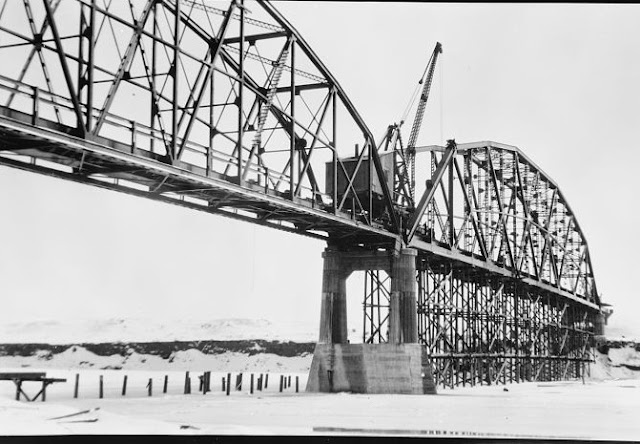
HAER MT-96-20
20. Southeast view, span no. 3 with false work (1930) - Wolf Point Bridge, Spanning Missouri River at State Highway 13, Wolf Point, Roosevelt County, MT

David Adolphson, Apr 2025

It appears the plan to fix up the bridge so that it can be used by pedestrians has been realized.
David Adolphson, Apr 2025

Friday, July 25, 2025

1921+1994 Ascota Bridge over St. Johns River in Jacksonville, FL

1921: (Archived Bridge Hunter; Bridge Hunter, no Historic Bridges)
1994: (no Bridge Hunter; no Historic Bridges; Satellite)

The full name is St. Elmo W. Acosta Bridge. He was the councilman who secured the funding for the 1,645' (500m) bridge. The 1921 bridge was the first one built across the St. Johns River. [SevenBridges]

"More simply called the Acosta Bridge named after the City Councilman instrumental in funding the original span known as the St. Johns River Bridge (1921). After Acosta died, the St. Johns River Bridge was renamed in his honor. Eventually, the new Acosta Bridge opened in 1994 replacing the older one. Today the Acosta Bridge has 6 lanes for cars, 2 pedestrian walkways, and 2-tracks in the median for the Skyway train. This is my favorite bridge on driving tours because of the magnificent view of Downtown from the crest." [VisitJacksonville, this is a summary of the main bridges]

Postcard via BridgeHunter

1924 photo via Pinterest via BridgeHunter


jaxhistory
"One hundred years ago, July 1, 1921, the Acosta Bridge was opened as the first span over the St. Johns River to move automobile traffic from one bank to the other."
Bridges Now and Then posted
"Jacksonville, Florida's, St. John's River Bridge opening day, June 1, 1921. Known as the St. John’s River Bridge, it was a toll bridge and an annual “pass” was available, which consisted of a tag or plate for the front of the vehicle. Tolls were taken up until 1940. The bridge was renamed the Acosta Bridge in 1947 in posthumous honor of St. Elmo W. Acosta, the city commissioner who championed the funding for the automobile and pedestrian bridge after World War I." (Jacksonville History Center)

Bridges Now and Then posted
July 1, 1921: Motorists and residents of Jacksonville, Florida celebrate the opening of the St. Johns River Bridge (later renamed Acosta Bridge). (Jacksonville Historical Society)

Jacksonville
The tolls were retired in 1940.
 
Jacksonville, this webpage has a lot of photos of the old bridge.
"April 1991: Construction of what would later become the northbound lanes of the new Acosta Bridge is under way. Once completed, the old Acosta Bridge was demolished and a second bridge was constructed that would eventually become the southbound span.   M. Jack Luedke/Florida Times-Union"

Street View, Jan 2022

The approaches look like steel girders.
Street View, Jan 2022

But the mainspan looks more like a concrete box girder. (I wish Bridge Hunters would cover modern bridges that aren't just plain girder bridges.)
Street View, May 2018

SevenBridges
"The new bridge features a box girder design; it utilizes pre-stressed concrete, making it much more reliable than its predecessor....The bridge is notable for allowing bicycle traffic in its commuter lanes. Between this, the sidewalks, and the Skyway rails, the Acosta Bridge is one of the most pedestrian-friendly bridges in the city. Just as the bridge offered the first path across the bridge for vehicle traffic many years ago, with its pedestrian-friendly design it continues its tradition of being ahead of the curve." It had been lit with neon lights, but they died in 2016.

DownTownJacksonville
"The new LED system cost $2.6 million and was installed by Miller Electric." 

Road/C&O Bridge over Kanawha Canal at Richmond, VA

(Satellite)

safe_image for With lawsuit lingering, CSX begins repairs to disputed Kanawha Canal Bridge

RichmondBizSense
"The original bridge across that section of the canal was destroyed in a flood in 1985. CSX built the replacement bridge by laying wooden planks atop an abandoned railway trestle, creating the version of the bridge that has been used ever since."

This map shows the original bridge and the fact that today's bridge was an industrial railroad spur. I'm guessing that the C&O spur was used to supply coal cars to the University of Richmond. This map also confirms that what Google Maps labels as East Branch Tuckahoe Creek was the Kanawha Canal.
1964/65 Bon Air Quad @ 24,000

Thursday, July 24, 2025

1965 Vandalia Lake Dam on Bear Creek and CSX/Pennsy Bridge over Kaskaskia River near Vandalia, IL

Dam: (Satellite)
Bridge: (Archived Bridge Hunter; Bridge Hunter; no Historic Bridges; Satellite)

The dam is 1600' (488m) long and 50' (15m) high. Its maximum storage is 13,460 acre-feet. The spillway has a width of 112' (34m). Even though it provides a water source for the region, recreation is considered its primary purpose. [snoflo]

Tyler Schmitt, Realtor, RE/MAX Alliance posted 3:00 video
Here is some footage of Vandalia Lake and the Kaskaskia River after all this rain we had last night (7-20/21-2025). Not something you see every year!
Bryan Grubaugh: We used to take inner tubes over that damn.
Ronda-Ian Brown: Did that flood the road by the spillway....
Bj Tedrick: Ronda-Ian Brown definitely
David Cantrell shared with the comment: "Flooding video around Vandalia from Tyler Schmitt. It has a railroad bridge and tracks visible in part of the footage (around 1:40). I'm unsure of which railroad is shown."
Paul Brewer: Bridge is CSX - St. Louis Line. Nice video!

Bear Creek empties into the Kaskaskia River northeast of Vandalia so that river is also running high.
The road bridge in the foreground is US-51.
Same video

This is one of the lower river levels that I found.
Street View, Dec 2022

CSX has done some work over the last decade to improve the piers.
Street View, Oct 2013

Uploaded by Melissa Brand-Welch via BridgeHunter

Precision fishing guide services posted 0:30 video
The dam at vandalia lake

I presume this is the road by the spillway. Google Maps does not have a street view of that road. This video was posted Jan 11, 2020. Five years ago.
Same video

Amtrak/NYNH&H and Road Bridges over Hutchinson River in Bronx, New York, NY

1908 RR: (Archived Bridge Hunter; Bridge Hunter; Historic Bridges; HAERSatellite)
 
The towers carry electric lines because this is on the electrified Northeast Railroad Corridor.
Street View, Jun 2024

Road Bridges


BridgeHunter_1870
This photo is also in HistoricPelham.
The design was bowstring arch truss. [HistoricBridges_1906]


2019 photo by Geoff Hubbs via BridgeHunter_1906

jag9889 photo via BridgeHunter_1906

HistoricBridges_1906
The bridge is 
a Scherzer rolling lift bridge.

Mosely Iron Bridge built the 1870 spans. Historic Bridges offered this bridge as an extant example of a bridge built by Mosely Iron Bridge.
Historic Bridges

Back to the railroad bridge


Street View, Jun2024

Two of the spans are up while the third is down.
1940 photo by George Votova via BridgeHunter_1908
"Built 1908; originally three parallel 2-track lift spans"

Photo from tugster.files via BridgeHunter_1908

HAER NY,31-NEYO,167--30
30. Hutchinson River Bridge. Bronx, Bronx Co., NY. Sec. 4207, MP 15.73. - Northeast Railroad Corridor, Amtrak Route between New Jersey/New York & New York/Connecticut State Lines, New York County, NY

This is the post that motivated these notes.
Amtrak posted
Many of our infrastructure investments are well-known already, and some you’re going to start hearing more about, like the Pelham Bay Bridge Replacement Project. The original bridge was built in 1907 and today serves over 50 Amtrak, commuter, and freight trains per day. Spanning the Hutchinson River in the Bronx (between Co-op City and Pelham Bay Park), the bridge is part of the Hell Gate Line on Amtrak’s Northeast Corridor.  It is well past its useful life and causes delays due to its age and twice-daily openings. 
A new replacement bridge currently in design will improve reliability, increase efficiency, boost speed, reduce delays, and more. We recently held a public information session with the local community to talk about the project in an open forum. Check out our presentation and learn more about the bridge and the project here: http://spr.ly/6189f6nAS
Nathan Green: I'll also mention that NYCDOT/NYSDOT is in the process of replacing the Shore Rd (vehicle) bridge just south of the Amtrak bridge in this photo. It is also from the early 1900s. It is undergoing the environmental review process right now.

Amtrak
The speed limit will be raised from 45mph to 70mph.
The navigation channel will increase from 8' x 67' to 35' x 100'.
There will be 70% fewer bridge openings.

Amtrak

Wednesday, July 23, 2025

I-195+US-6 Washington Bridge over Seekonk River in Providence, RI

(Satellite)

This bridge has become an ongoing saga. RIDOT did an emergency shut down of the westbound bridge when they discovered a broken rod. RIDOT claims that it broke because of an overweight truck. But photos indicate that it broke because of corrosion. In fact, it was probably broken during previous bridge inspections. The following video explains the issue better than I can.

Casey Jones has a collection of videos about this video. I watched several of his videos as they came out, but I skipped some of them because I could not stand listening to the RIDOT guy. As Casey once observed, RIDOT seems more interested in paying lawyers than engineers. I have followed Casey for a while now, and it is worth noting that he is as quick to complement good DOTs as he is to criticize bad DOTs. In other words, he is interested in the truth, not sensationalistic clickbait. Examples of DOTs that Casey thinks did a good job handling a serious bridge problem are OhioDOT and IowaDOT.

Ken Block posted three photos with the comment:
Bridge Update: An Expert Weighs In, Part 1.
One of the primary architects of the Washington Bridge wrote an opinion piece in the Providence Journal that criticized the RIDOT. He said a lot, so I decided to tackle his most important points one at a time.
The architect, Lazlo Siegmund, tore into the RIDOT over the broken rod shown in the attached photos. RIDOT Director has attacked me and others over our assessments of this rod, claiming that we are not properly educated to do so. Well, Mr. Siegmund most certainly is.
"It was evident even to lay persons that the breakage [of the rod] was not new and RIDOT should have known that the bridge had been carrying the traffic loads with the broken rod(s) for a long period."
Ridiculously, Alviti claimed that this rod had broken just before the bridge was closed, and had done so due to a "heavy truck." Alviti ignores the obvious fact that this rod had corroded through and through. This kind of decay does not happen overnight. It takes years, if not decades.
Alviti has never walked back his "heavy truck" defense for why RIDOT failed to detect that the bridge was about to fail. You don't need an advanced degree in metallurgy or engineering to know that the kind of rot you see in these pictures should have been noted years before the bridge was shut down.
Gov. McKee and Director Alviti have both dismissed the assessments of laypeople and outside engineers, such as Casey Jones, who have pressed for answers on how this could have possibly occurred. Siegmund's analysis cannot be as easily ignored.
The "see no evil, hear no evil" duo of McKee and Alviti has spent the last year and a half deflecting accountability for this monumental government failure away from RIDOT. They cannot be allowed to succeed with this cover-up.
1

2

3

32:12 video
What the problems with bridge construction in Iowa has to do with the Washington Bridge in R.I.

22:04 video
Leaked Washington Bridge Forensic Report
For decades, RIDOT has been ignoring corrosion problems found by bridge inspections.