The movable bridges on this canal go down under the water rather than swing to the side or go up.
You can see tow lines in the photo above. But this photo explicitly shows that the bigger ships are towed through the canal. Through the truss we can see another ship coming. Because the canal is obviously one way, they convoy ships through it.
 |
| Bresilda Quinto posted Tight Squeeze Corinth Canal, Greece. Rose Smith shared [There are some comments implying the ships have side thrusters.] Highway Engineering Discoveries posted Michael Gibson: When I went through in 89 HMS Sheffield F96 it was rattan and pneumatic fenders and believe it or not bamboo poles . Bridge and Bridge roof plus tiller flats manned to steer through . |
 |
| The Marine Buff posted The Corinth Canal, resembling a massive cut through Greece with a giant knife, spans 6.4 kilometers and was completed in 1893. This engineering feat required extensive excavation through solid rock and serves as a crucial shortcut for maritime traffic between the eastern and western Mediterranean. The canal's construction was a monumental task, taking 11 years to complete. The project faced numerous financial and logistical challenges, including initial bankruptcies of construction companies and significant engineering difficulties. Despite these hurdles, the canal was eventually completed and opened, significantly reducing travel time for ships by eliminating the need to navigate around the Peloponnesian peninsula. Throughout history, various attempts were made to construct a canal at this location, dating back to ancient times with efforts by Periander in the 7th century BC and Roman Emperor Nero in the 1st century AD. However, these early attempts failed due to technical and financial constraints. The canal cuts through the narrow Isthmus of Corinth, which connects the Peloponnese to mainland Greece, creating a direct link between the Gulf of Corinth and the Saronic Gulf. This strategic location makes it an essential passage for small to medium-sized vessels, although its narrow width limits its use for larger modern ships. Today, the Corinth Canal is not only a vital maritime route but also a popular tourist attraction, offering stunning views and a unique navigational experience through its steep, rock-cut walls. |
Ocean Fight posted two photos with the comment:
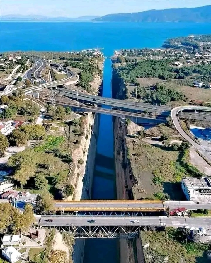
The Corinth Canal is a man-made waterway that connects the Gulf of Corinth in the Ionian Sea to the Saronic Gulf in the Aegean Sea, effectively separating the Peloponnese peninsula from mainland Greece. Here are some key details about the Corinth Canal:• Location: The canal is located in Greece and cuts through the narrow Isthmus of Corinth, which is about 6.4 kilometers (4 miles) wide.• Length and Dimensions: The Corinth Canal is approximately 6.4 kilometers (4 miles) long, 24.6 meters (81 feet) wide at sea level, and has a depth of around 8 meters (26 feet). The sides of the canal rise up to about 79 meters (259 feet) at their highest point.• Construction: The idea of building the canal dates back to ancient times, with the first attempts made during the reign of the Roman Emperor Nero in the 1st century AD. However, the canal was not completed until the late 19th century, with construction taking place from 1881 to 1893.• Purpose: The Corinth Canal was constructed to provide a shortcut for maritime traffic between the Ionian Sea and the Aegean Sea, eliminating the need for ships to navigate around the Peloponnese peninsula, which would have added an extra 185 nautical miles (343 kilometers) to their journey.• Challenges: Despite its strategic importance, the canal’s narrow width and shallow depth limit its use to smaller ships and vessels. Larger modern ships cannot pass through the canal, so its significance in global trade is limited.• Tourism: Today, the Corinth Canal is a popular tourist attraction. Many visitors come to see the impressive engineering feat and take boat tours through the canal. It’s also a favorite spot for bungee jumping due to the height of the canal walls.The Corinth Canal, with its steep limestone walls and narrow passage, is a remarkable sight and a testament to human engineering, even though its practical use in modern shipping is relatively limited.
 |
| 1 |
 |
| 2 |
 |
| Florela Petculescu, Mar 2021 Wonderful Engineering Discoveries posted Corinth Canal, Greece |
 |
Greeker than the Greeks posted The Corinth Canal, a man-made wonder, is a waterway across the Isthmus of Corinth, connecting the Gulf of Corinth in the northwest with the Saronic Gulf in the southeast. Before the canal was built, ships were forced to make the long journey around the peloponnese Peninsula, adding an extra 320 kilometres to their journey. In around 600 BC, Periander, the founder of the Cypselid Dynasty of Corinth, had the brilliant idea of taking ships out of the water and pulling them overland, on a type of railroad track; the diolkos (parts of which are still visible today), on which ships were hauled on wheeled wagons across the Isthmus. This practice was used until about the 9th century, when ships had become too large for this system. In 1882 work began on digging out, mostly by hand, the Corinth Canal, which opened 11 years later, in 1893. The canal walls are more than 240 feet (80m) high, with an in-water depth of 24 feet (8m) and just over 3.7 miles (6km) long. The Canal is a popular tourist attraction; large ships being pulled through the canal by small tugboats, a sight worth seeing. Photo by DronEye [The comments offer several more photos.] |
 |
| Weird but True posted The construction of the Corinth Canal, a remarkable engineering feat of the 19th century, began in 1882 and concluded in 1893. Its purpose? To create a direct route between the Gulf of Corinth and the Saronic Gulf, saving ships from the arduous and perilous 700-kilometer journey around the Peloponnese peninsula. At first, the task of building the canal was undertaken by the French company Société Internationale du Canal Maritime de Corinthe. However, the project faced significant challenges. The land conditions were treacherous, financial difficulties plagued the construction, and landslides from the steep canal walls caused delays. Windy conditions further complicated navigation, making the task even more daunting. Despite these obstacles, around 2,000 workers persevered, carving out a passage 6.4 kilometers long and 21.3 meters wide. After 11 years of grueling work, the canal was finally completed. Though narrow by modern standards and unsuitable for many of today’s larger ships, the Corinth Canal remains an iconic waterway and an impressive testament to human determination and ingenuity. This historic canal stands as a reminder of the ambition to conquer natural barriers and improve global trade routes, bridging two seas while offering a glimpse into the past of engineering innovation. ~ Weird but True |
 |
| Ocean Fight posted An aerial view of the Corinth Canal, a narrow artificial waterway connecting the Gulf of Corinth with the Saronic Gulf in Greece. This engineering marvel, completed in 1893, cuts through the narrow Isthmus of Corinth and significantly reduces the travel distance for ships between the Aegean and Ionian Seas. The canal is 6.4 kilometers (4 miles) long, 24.6 meters [81'] wide at its base, and has steep limestone walls that reach up to 63 meters [207'] in height. |
It is just 70' wide at sea level. It is 81' wide at the top of its rock walls that go up to 300'. The 70' width limits the width of ships to 58'. The canal is also used for bungee jumping from a height of 256'.
The canal is 3.9 miles long and has a draft of 26'. [britannica]
Does the rock slope change because they know there was a different type of rock or because there was a previous rock slide?
 |
| Randolfo Santos, Jan 2020 |
 |
| Street View |
 |
| Street View from the other side of the Old Bridge |
The canal is currently [Summer of 2021] closed because of a rockslide that happened in Jan 2021. (source)
From the beginning, the canal was prone to rockslides because the sedimentary rock has been weakened by the extensive seismic activity in the area. A lot of work has been done over the decades to stabilize the canal walls. Unfortunately, some of that work is now failing.
"According to the studies carried out so far by the Ministry of Infrastructure & Transport, moisture and erosion caused the loss of the stone piers that supported and protected the ground from falling into the canal. The preliminary work on the studies is expected to be completed in September. Then the construction for the project will go up for bid, and the preliminary works on the sides of the Canal will begin subsequently." [GreekReporter]
A satellite image caught a freighter in the canal. This is rare because most freighters are now too big to use the canal. It is used mainly by tourist ships.
 |
| Satellite |
Wow!
ReplyDelete