These are notes that I am writing to help me learn our industrial history. They are my best understanding, but that does not mean they are a correct understanding.
Saturday, August 13, 2022
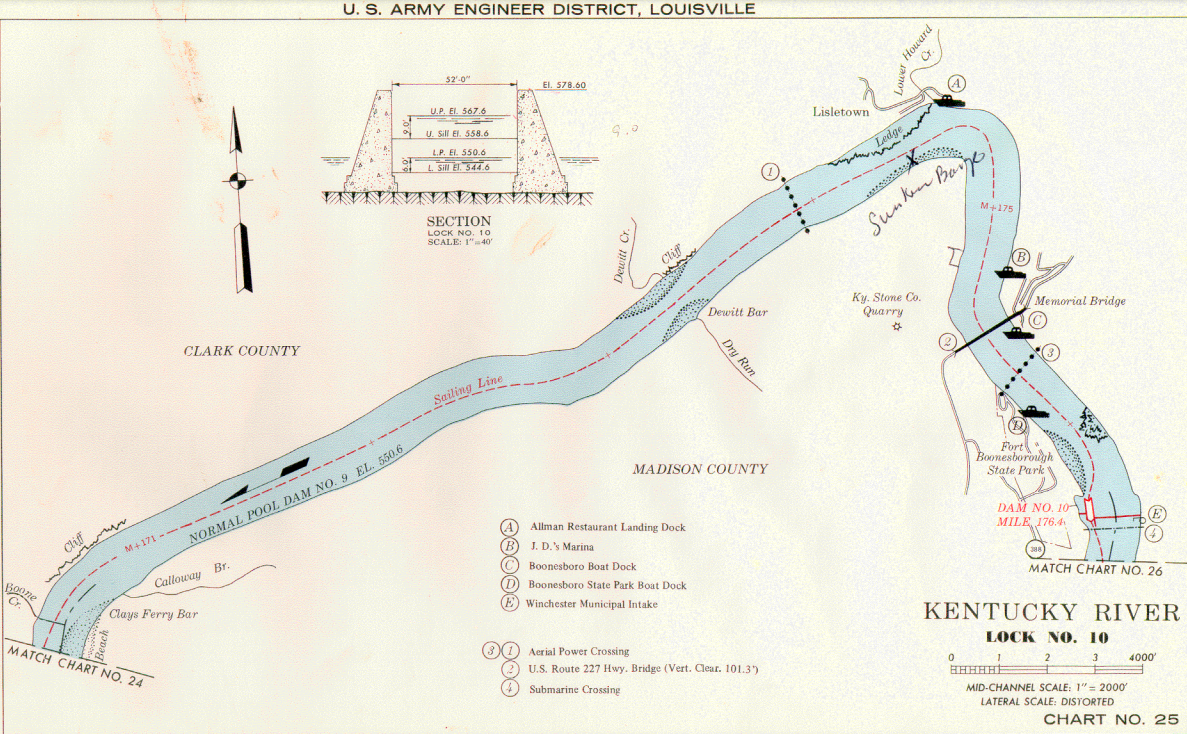
1904-1995 Kentucky River Lock and Dam #10 near Ford, KY
Lock 10, located on the border of Madison and Clark counties near Fort Boonesborough State Park, undergoes renovation by the Kentucky River Authority. In the 1830s, engineers began the process of building locks and dams along the Kentucky River in order to provide reliable year-round navigation. In 1880, the U.S. Army Corps of Engineers restored the early dams and completed 14 locks and dams on the 250-mile river. Today, only four of the locks are in operation. The Blue Grass Chemical Agent-Destruction Pilot Plant is committed to safely destroying chemical weapons while protecting nearby communities, their historic sites and the environment.
Kentucky maintains these dams because as much as 22% of the state's population draws its drinking water from the Kentucky River watershed. Dam #10 is the largest on the river. "The project will not be cheap — estimates given to KRA from consultants place the total cost to renovate the dam between $26 million and $28 million, with another $11 million to $12.5 million added on to that if KRA decided to renovate the sealed lock in the structure as well....The cost of the project to renovate the dam will be carried by the customers who use the water supplied by the pools the dams create." [WinchesterSun]
Brian Cartier, Jul 2022 [The lock was closed in 1994. I don't understand how dirt accumulated in the downstream approach in such as well defined pile.]
TheClio Leadingham, Christopher et. al. "Kentucky River Museum." Clio: Your Guide to History. June 10, 2021. Accessed August 13, 2022. [A maneuver boat is changing the adjustable crest.]
An adjustable crest must be a feature of the auxiliary dam. I see some "stuff" on top of that dam. This image shows that the river must be significantly higher than the main dam before water will spill over the auxiliary dam.
0:19 video @ 0:14, Feb 5, 2019 [This is another demonstration that much of the Mississippi River watershed was flooded in 2019. The main dam is just a ripple in the water!]
2 of 10 photos posted by Rob Stone Photography with the comment:
Former Lockmaster and Operator Houses
📍 Kentucky River Lock and Dam No. 10
Just steps from the dam sit the houses where lock operators and their families once lived.
Lockmasters had to be on call day and night as boats moved through the river. The job didn’t end when the shift did. Families raised children here with the sound of water, gates, and engines always nearby. The river set the schedule, not the clock.
It’s easy to focus on the dam itself, but places like this only worked because people lived right beside them.
Today, these buildings are preserved as part of Fort Boonesborough State Park.
a
b
Jan 26, 2026. Kentucky got more snow than Chicagoland did.
Fort Boonesborough State Park posted Today’s view of Kentucky River Dam #10 from Fort Boonesborough State Park.
Henry Parks: The river is on the other side of the field the picture is of the field zoom in you will see river still flowing.
Nathan Stephens: This looks like a Fox News report..fake news trying to make it look worse than it is..that’s the field beside it..it’s not froze over
Timothy Ray: Winter of 77/78 the river froze over and someone drove a VW across the river at the boat ramp
The long black thing at the base of the hill is the lock and we can see the round caissons of part of the dam near the right.


%20Watch%20_%20Facebook.png)


No comments:
Post a Comment