Ribbon of Light: (Satellite)
The bridge with the two arches is the 6th Street Bridge.
 |
| HAER CA-271-30 30. SIXTH STREET BRIDGE AT CENTER. LOOKING NORTH. FOURTH STREET BRIDGE AT CENTER REAR. FIRST STREET BRIDGE AT CENTER DISTANCE. - Los Angeles River Bridges, Los Angeles, Los Angeles County, CA |
 |
| HAER CA-271-30 31. SIXTH STREET BRIDGE. LOOKING SOUTHWEST. |
 |
| HAER CAL,19-LOSAN,77--67 (CT) 67. South side of Sixth Street Bridge crossing Los Angeles River. Looking north. Note First Street Bridge at rear. - Sixth Street Bridge, Spanning 101 Freeway at Sixth Street, Los Angeles, Los Angeles County, CA |
 |
| Street View, Jun 2022 |
 |
| Street View, Jan 2022 |
I noticed above that the arch on the left was still being constructed, so I looked for a view on that end.
 |
| Street View, Jan 2022 |
I zoomed in on the view from 7th Street because it caught the boom of a concrete pump truck in action.
 |
| Street View, Jan 2022 |
 |
| American Society of Civil Engineers posted Congratulations to ASCE’s 2024 Outstanding Civil Engineering Achievement award winner, the Sixth Street Viaduct Replacement! Learn more about the largest and most complex bridge in Los Angeles history + this year’s award recipients: https://bit.ly/4f9jLzq. |
.jpg) |
| The B1M posted LA's iconic Sixth Street Viaduct has been replaced with an impressive new structure called the Ribbon of Light. Designed by Michael Maltzan Architecture and captured here in a fantastic photo by Iwan Baan, the 1,067-metre structure features 10 concrete arches that nod to the original viaduct's famous form while enabling it to span railway lines, the Los Angeles river and a new public park. Image courtesy of Iwan Baan. More photos on our Instagram - https://www.instagram.com/p/Cf6VhAos0WD/ See how the bridge structure was engineered to resist seismic activity in the video over on our YouTube channel and TheB1M.com — links in our bio [So Instagram does not allow links in their comments? I found it here.] |
 |
| SixthStreetViaduct-fact_sheets During the summer months, liquid nitrogen is added on site to the ready-mix trucks to cool the mix down and slow down the curing time so that it doesn't develop surface cracks. |
Note in this concept drawing that there is a bunch of "green" under the viaduct and a long U-shaped bike path connection.
 |
| mmaltzan |
In practice, they ended up with a 104' helical ramp. (There is a concern that the new bridge will cause the gentrification of the Boyle Heights area on the east side of the bridge.) [ArchitecturalRecord, paycount 3]
 |
| dezeen, July 8, 2022, The photography is by Iwan Baan. Michael Maltzan Architecture completes Ribbon of Light bridge with swooping arches in LA "The 3,500-foot-long (1,067-metre) concrete and steel bridge replaced a deteriorating structure, called the 6th Street Viaduct, that was built in 1932. While the previous structure only serviced cars, the Ribbon of Light, which stretches over the Los Angeles River as well as the US 101 highway and local neighbourhoods, is also geared towards bicycles and pedestrians." |
 |
| Carlos G. Lucero posted 6th Street Bridge - Sixth Street Viaduct Los Angeles California |
 |
| Carlos G. Lucero posted 6th Street Bridge - Sixth Street Viaduct Los Angeles California |
We can clearly see the earthquake isolation bearings that have been installed in all of the piers.
 |
| dezeen, The photography is by Iwan Baan. |
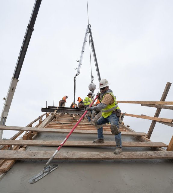
Speaking of a concrete pump truck.
 |
| ArchPaper, cropped The arches are built of cast-in-place concrete poured at a rate of 4 vertical feet per hour. (Gary Leonard/Courtesy the City of Los Angeles Bureau of Engineering) |
There are five stairways built into the arches to connect the bridge to ground level.
 |
| SixthStreetViaduct |
Now that the viaduct is done, work is to begin on a 12-acre park under the viaduct.
What the area looked like before the viaduct was built.
 |
| 1928 Los Angeles Quad @ 24,000 |
This is the first topo map that shows the viaduct. When I first looked at a satellite map, I noticed that just a small part of it was built over the river and tracks. Most of it was built over buildings. It struck me as overkill to build over buildings. But these topo maps taught me that the reason they have a bridge high in the air is to create a gradual grade up to the top of the hill that is just east of the Santa Ana.
 | |
|
This is the best view I could find of the side of that hill.
 |
| Street View, Apr 2022 |
While checking out the side of the hill, I found this view of one of the stairwells being built.
 |
| Street View |


No comments:
Post a Comment