(no Bridge Hunter; no Historic Bridges;
HAER;
Satellite, 803 photos)
This bridge opened in 1932 to relieve traffic congestion at the Fremont Bridge.
The official name is the George Washington Memorial Bridge. It "is a 2,945-foot (897.6 m) long, 70-foot (21.3 m) wide cantilever and truss structure." It was recoated in 2018-19 with a "moisture-cured urethane." (They made the rain and humidity in the area work for them instead of against them.) [
CoatingsPromag]
"The Aurora Avenue Bridge, a nearly 3,000-foot steel cantilever structure is one of Seattle's longest and tallest spans. It provided an important early crossing of the Lake Washington Ship Canal for motorists on western Washington's north-south motor route, the Pacific Highway." [
HAER_data]
 |
HAER WASH,17-SEAT,12--7
7. CONCRETE SUPPORT PIERS LOOKING SOUTH - Aurora Avenue Bridge, Spanning Lake Washington Ship Channel, Seattle, King County, WA |
 |
Bridges Now and Then posted
"George Washington memorial bridge (Aurora Bridge). Looking east (from airplane) across bridge to Capitol Hill; Fremont bridge in foreground." Seattle, Washington, c. 1950. (Seattle Public Library)
|
 |
HistoryLink, License: Creative Commons Attribution-NonCommercial-NoDerivs (CC BY-NC-ND)
Seattle Postcard Collection. PH Coll 798, University of Washington Special Collections
This bridge completed the final link of US-99 from Canada to Mexico. US-99 was decertified in 1967 to State Route 99.
It is made with silicon steel and "the piers are set on underground pilings of Doug-fir logs which are in turn set on gravel, sand, and clay under Lake Union -- there's no bedrock there. There are 684 logs (piles) under the north main pier and 828 piles under the south main pier." |
 |
got99problems
Some people advocate sacrificing 2 of the 6 lanes of traffic to provide a better experience for pedestrians and to accommodate bicycle traffic. |
"In 2006 the Aurora Bridge carries 100,000 vehicles a day." Guard rails have been added between the traffic and pedestrian lanes. [
HistoryLink] I think 100k/day means that all six lanes are heavily used during rush hour.
 |
Scott Szloch posted
The Aroura bridge Seattle |
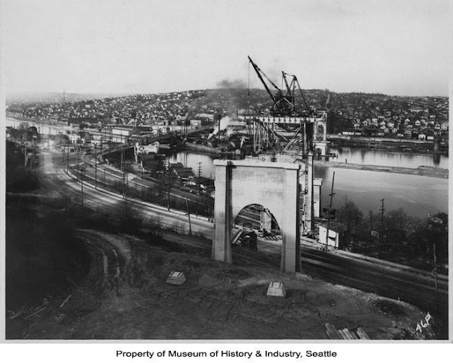 |
washington.edu, ca. 1931, Pierson Photo. Co.
Construction on the George Washington Memorial Bridge, commonly known as the Aurora Bridge, began in 1929, and the bridge was opened to traffic on February 22, 1932. The nearly 3,000-foot long, cantilever and truss structure spans Lake Union between the Fremont and Queen Anne neighborhoods and completes the final link of U.S. Highway 99 from Canada to Mexico. Designed for the Washington State Highway Department, it is the first major highway bridge built in Seattle. This view of construction on the Aurora Avenue Bridge is taken from the south end. The Fremont Bridge and a McKale’s service station are visible to the left. |
 |
MyNorthwest
The original Aurora road in the area was named by a dentist, Edward C. Kilbourne, from the name of his hometown, Aurora, IL. Aurora, IL, was named in honor of Aurora, NY. And that town was named Aurora after the "Goddess of the Dawn in Roman mythology" because of the unique sunrises in the area. |
An 18' (5.5m) high troll sculpture was added in 1990. [
HistoryLink]
Several of the Google search results has the word "suicide" in the title.
This webpage is the only one that I looked at. This bridge is second only to the
Golden Gate Bridge. "230 people have killed themselves by jumping either into the ship canal, as in 80% of the cases, or into the heavily populated neighborhood below the bridge. The drop is 155 ft [47m] at the peak and is fatal for 69%, with almost all survivors landing in the water." [
PsychiatryOnline]
 |
HistoryLink, License: Creative Commons Attribution-NonCommercial-NoDerivs (CC BY-NC-ND)
Seattle Public Library Special Collections (spl_shp_41016)
George Washington Memorial Bridge and Mt. Rainier, Seattle June 29 1941
"The War Department approved a shipping clearance of a minimum of 135 feet and 150 feet over the thalweg (the center of the shipping channel). The captains of tall-masted ships docked in Lake Union protested this, but their day was over and they had to remove their vessels before the bridge trapped them in the lake forever.
"As to the actual height of the bridge at its highest point, various figures are floating around, from 155 feet to 176 feet. (Both the low and the high figure are drawn from various Washington State Department of Transportation sources.) An extremely exacting medical study of the care of suicidal jumpers off the bridge, a study published in 1983 and greatly concerned with length and velocity of fall, reports the height to be 164 feet ('The Effects of Prehospital Trauma Care...')." |
Bonus: while looking for views of the bridge, I came across this view of two floating
drydocks.
I'm glad that the hard-to-climb fence that they built doesn't obstruct the view. Note that I included the above shipyard in the background.
The fence cost $5m, and "it immediately became a memorial for those lost to suicide, with flowers and pictures affixed to various points on the bridge." [
HistoryLink]
 |
Bridges Now and Then posted
Seattle's Aurora Bridge (officially the George Washington Memorial Bridge), c. 1932. I believe that is Fremont Bridge to the left. (Seattle History) |


No comments:
Post a Comment