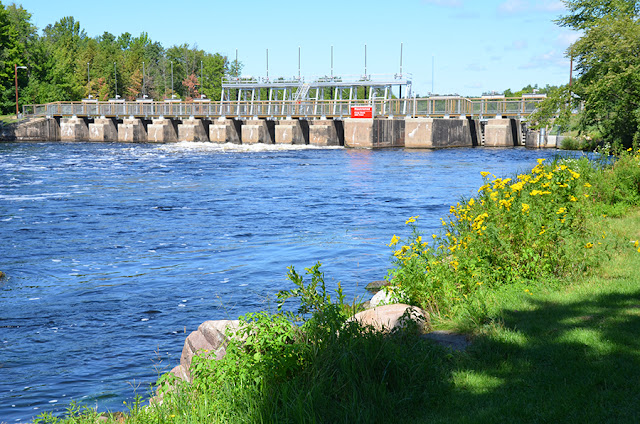
This dam uses sluice gates.
"A wooden structure was replaced with concrete in 1904. The concrete structure consists of 13 gates that are 8 feet each, and one 12 foot log sluice....The dam itself has a walkway that is open to the public that allows you to walk across the river on the dam structure." [JohnWeeks]
 |
| JohnWeeks |
"By providing a consistent flow of water throughout the navigation season, the Pokegama Dam enhanced navigation and aided in the commercial development of the Upper Mississippi River. The dam site was also one of the earliest non-Indian settlements in the region and by the late 19th century was attracting some of the first tourists to the area. The dam had a devastating impact on the Ojibway Indians who lived on the lake's shores. The project precipitated a century-long conflict between the tribe and the U.S. government over the damages resulting from the inundation of tribal lands and property." [HAER-data]
I presume the opening to the left of the six sluice gates is the 12' log sluice.
 |
| HAER MINN,31-GDRAP.V,1- 3. Upstream view of gates, looking southwest - Lake Pokegama Reservoir Dam, Grand Rapids, Itasca County, MN Photos from Survey HAER MN-66 |
 |
| HAER MINN,31-GDRAP.V,1- 7. Photographic copy of historic photograph, 1904, west end of dam |
John Weeks posted eight photos with the comment: "I‘m in Grand Rapids (the Minnesota version) for an event, so I went out bridge hunting to get my 10,000 steps for the day. The Mississippi River flows through town and once had a nice waterfall until they covered it up with a paper mill dam. I covered this area in my second edition of the “Bridges & Structures Of The Mississippi River.” I need to get back up here with my real camera on a nice sunny day to get updated photos for the long awaited 4th edition. See the photo captions for more details."
 |
| 1 Very beautiful city entrance monument along highway US-169 as you enter Grand Rapids from the south. |
 |
| 2 US Army Corps of Engineers style park signage at the Pokegama Dam public use area. If you look closely, you can see the BNSF railroad bridge in the background just above the second “issi”. That is the first bridge over the Mississippi River in the Grand Rapids area. |
 |
| 5 US-169 bridge over the Mississippi River. Again, there is no good access to get a profile view of the bridge. It is mostly a boring ugly concrete bridge, so no big loss. |
 |
| 7 Next up is the Horn Bridge. It is kind of neat that they put the bike path under the bridge. It improves safety since the locals seem to have trouble with stopping for pedestrians in crosswalks. |


No comments:
Post a Comment