 |
| Niagara Action posted An aeriel view of Niagara Falls taken around 1922. Jim Myers shared |
The first factoid to consider is the Niagara Escarpment. It is the exposed edge of the Niagara dolostone sedimentary layer. The dolostone is harder than the shale layers that surround it. So it has resisted the erosion that has removed the neighboring rock. It is responsible for the Door Peninsula, the west side of the Georgian Bay and the cliffs that cut across Ontario.
 |
| CC BY-SA 3.0, Link |
 |
| Wisconsin Field Guide posted The Niagara Escarpment is the backbone of eastern Wisconsin, and most people never knew they were looking at it. The same ridge of rock that sends the Niagara River over its famous falls runs straight through Wisconsin. It arcs about 1,000 miles around the Great Lakes, from New York through Ontario and Michigan's Upper Peninsula, then into the Door Peninsula and on to southeast Wisconsin. Wisconsin holds about 230 miles of it, stretching from the tip of Door County down to Waukesha County. The story starts about 420 million years ago, when warm, shallow seas covered this part of the continent. Sea creatures piled up, hardened into dolomite, and formed a tough cap of rock. Later, glaciers scraped across the land and wore away the softer layers beneath. What stayed behind was a long, steep cliff. In Wisconsin, it reaches heights of about 250 feet on the western edge of Door County. Door County owes its personality to that rock. Cave Point County Park has limestone cliffs where waves boom into sea caves. Peninsula State Park has bluffs with views over Green Bay. Kayakers paddle along rugged shorelines, and hikers climb ledges that feel like another world. Without the escarpment, the Door would be a flat finger of land, and nobody would call it the Cape Cod of the Midwest. The ridge keeps going south. High Cliff State Park sits on the shore of Lake Winnebago, with a limestone cliff, a historic lime kiln, and forest trails. Near Oakfield, the Ledge runs for miles, with rare plants and trees that are over a thousand years old. Farther south, abandoned mines shelter more than 50,000 hibernating bats. The escarpment also hides more caves than anywhere else in Wisconsin, and Native people left effigy mounds, petroglyphs, and pictographs along its edge. That makes Wisconsin the quiet hero of the story. Tourists crowd the railings at Niagara Falls, yet the same rock holds up the cliffs of Door County, a few hours from Milwaukee. Wisconsinites get hiking, kayaking, and sunsets over the water without the lines. The escarpment also asks for care. Mining, quarrying, and development press against it, and conservation groups work to protect the forests and cliffs. Every Wisconsinite who climbs a ledge or paddles beneath a bluff is touching 420 million years of history. We just call it a good day up north. |
This diagram shows the dolostone hard cap stone.
 |
| John Vencent posted via Dennis DeBruler |
Look at the last figure in geomich to see how the sedimentary layers were bent into a shape of nested bowls under lower Michigan. Those "bowls" explain the circular shape of the Niagara outcroppings. When you consider that the quarries in Lemont, IL, and Bloomington, IN, are also in the Niagara seam, you see an even more complete circle.
Unfortunately, this map got cut off on the Illinois side.
 |
| Amber Pacquin via Dennis DeBruler |
 |
| Bruce Verbeck posted The Niagara Escarpment, this is why there is a Niagara Falls. Paul McRoberts: It's Grimsby. Deanna Donelson shared Mark J Stachowski: I forget the details, but that was essentially was the depth of Lake Ontario at one point in time. Jason Ramsay: Lake Iroqouis |
The Niagara layer was deposited about 430 million years ago. [wgnhs]
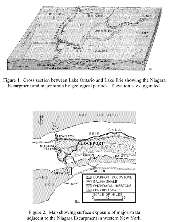 |
| HAER-data, p15 |
I used Street View to find evidence of the escarpment in St. Catharines. This shows how the road goes up a hill and the houses in the distance are significantly higher. This taught me that a line of trees on the satellite map is the escarpment.
 |
| Street View |
A second factoid is that the Welland Canal has three locks in a row (#4-#6) and another close by (#7) that raise ships about 60m (200').
A third factoid is that The Second Welland Canal had Neptune's Staircase just west of the current 3-flight locks (#4-#6).
I know how to access topo maps for the USA. But I don't know how to do it for Canada, or I would have looked at some topo maps of this area years ago. However, I did find a 1910 topo map this week while researching the locks on the Second Welland Canal.
%20-%20Explore%20the%20gems%20of%20our%20local%20.png) |
| BrockMap |
I had to remind myself that the current Welland Canal was not built until 1932. In 1910, the Third Welland Canal, the blue line on the right, would be the active canal. The Neptune's Staircase would be the horizontal orange line on this map. Below I added a red line where I think the flight of 3 locks are. It took me quite a while to decide where to add the line. I don't think the topo lines are real accurate. Fortunately, I was able to "drive" the street view along Welland Canals Parkway to learn that the engineers would rather built the locks with embankment walls rather than cut them into the hill.
%20-%20Explore%20the%20gems%20of%20our%20local%204.jpg) |
| BrockMap plus Paint |
A problem that bothered me was that the Niagara Falls is further south than the "high rise" locks.
 |
| Satellite |
Then when I was looking at the topo map, I noticed that the close lines representing the location of the escarpment were further north.
%20-%20Explore%20the%20gems%20of%20our%20local%20.png) |
| BrockMap |
That is when I remembered another factoid: over the millenia, the falls has eroded itself miles into the escarpment. So that solved the problem of why the Niagara Falls was further south than the clusters of locks. It helped that the topo map so clearly showed that erosion.
The escarpment makes a green belt across Hamilton, ON.
 |
| Satellite via Dennis DeBruler |
The escarpment not only created the Niagara Falls, but it also created the waterfalls in Rochester, NY. Rochester was founded because of the hydropower provided by these falls.
 |
| 9:54 video @ 8:59 |

No comments:
Post a Comment