Friday, September 29, 2017

Aban/C&NW/CGW crosses over C&NW

(Satellite)
Mark Llanuza posted
My before and after shot at Lombard IL 1980 and 2015 on tre CGW line
The trail builders decided to add curves and build brand new bridges to keep the bridges shorter of the 3-track C&NW and St. Charles Road.

This was out in the boonies in 1938. The current St. Charles Road has been built since then. The 1938 St. Charles Road is now St. Charles Place.
1939 Aerial Photo from ILHAP
Mark Llanuza posted
Its 1980 westbound crossing over The CNW
Update:
Mark Llanuza posted
Its 1980 with westbound crossing over the CNW main line in Lombard IL
Jack Morgan Did that curve around the bridge supprt on main three have any restriction at all? It likely isnt as sharp as it looks but I still cant see trains doing 60+ mph around it..?Debbie Boers I always wondered about little curve too. I rode few scoots back then and don't remember any slowing down for it. I believe track speed was 70 MPH (psgr) most everywhere on the Galena Divn.
Mark reposted his older photo as a standalone photo:
Mark Llanuza posted
Its 1979 eastbound commuter goes under the the former CGW line with westbound Frt coming at Lombard IL
Chris John posted
This is what was left of the CGW bridge over the C&NW in Lombard, Illinois in November, 1984.
Third photo posted by Marty Bernard
CGW 104C crossing CNW, Lombard, IL in January 1965. Rick Burn photo.
Sam Richards Eastbound or westbound?
Sam Richards So St. Charles Road overpass is under the eighth car back, approximately? I grew up in Elmhurst, and my mom drove often to my uncle's in Lombard, saw this bridge often, but never a train on it. Saw several, though, looking out back window of the Burger King about a half-mile east of here on St. Charles!
Rick Hess WB if St. Charles RD is passing below the 8th car. This would make it #143 which was called for Noon @ the Chicago Transfer. The other scheduled WB, #91, had a Midnight call time.

BSNF/Santa Fe 1910 Bridge over Spoon River near Dahinda, IL

(Bridge Hunter, no Historic Bridges, Satellite)

I would have ignored yet-another-railroad bridge until I noticed it was over the Spoon River. I remember Spoon River is where the KJRY had a truss bridge collapse. Fortunately, railroads are much more willing to maintain truss bridges than IDOT is. This is a pin-connected Parker truss that was built in 1910.

The track speed is high for such an old bridge.(new window)

Aerial views of four trains running over the trestle spanning the Spoon River at Dahinda, Illinois. This is the BNSF's Chillicothe subdivision. BNSF 7674 Wes.

Since it is the Chillocothe subdivision (former Santa Fe), I thought it would be just the usual collection of pigs, stacks, and racks. But there is a mixed freight train.
It looks like the three 4-bay NS hoppers are carrying tock (URL)
In some of his photos in Bridge Hunter, Steve uses his shoe to demonstrate how big some of the pins are.
URL

Bryan L Mckillip posted
An 1870s railroad bridge in Dahinda Illinois
Dennis DeBruler Bridge Hunter indicates it is a 1910 bridge. Since this is on the former Santa Fe mainline of the BNSF, I would have to agree with 1910. I've noticed that Santa Fe kept using pin-connected eyebar designs for their newer bridges. https://bridgehunter.com/il/knox/bnsf---spoon-river/

A portal view


KJRY/TP&W Bridges over Spoon River near Siville, IL

(Old Bridge Hunter, New Bridge HunterSatellite of Old Truss, Satellite of Replacement Steel Girder)

Fmiser photo from Bridge Hunter, License: Creative Commons Attribution-Share-Alike (CC BY-SA)

John Stell posted three photos with the comment: "Here are three slides looking east of the Spoon River Bridge at Seville.  Notice the wood 4x4's driven under the rail in middle picture.  The last photo shows the piers.  And the nudists were waving.  John Stell slides on 4-8-05."
1

2

3


Keokuk Junction Railway wrecked this bridge over Spoon River even though it had been inspected just a few months earlier. "Built 1890; collapsed Sept. 16, 2013; replaced with deck girder spans and reopened May 21, 2014." [Old Bridge Hunter]

"Built for the Missouri Pacific Colorado River crossing in Bay City, Texas; moved here in 2014" [New Bridge Hunter]

Four photos were posted on Facebook with the comment:
A train carrying corn syrup derailed just off of Route 95 on Seville Road, sending freight cars into the Spoon River yesterday 9-16-13. Here is an article link and a copy of their photos. http://www.cinewsnow.com/news/local/T-224005941.html. Here is another link about it. http://peoriastation.blogpeoria.com/2013/09/16/bridge-collapse-wrecks-train-near-seville/ [I see both links are now broke! :-( It seems I should ignore copyright considerations and copy the content so that it won't disappear. One of them mentioned that corn syrup was a pollutant as far as the fish was concerned. Some died.]
1

2

3

4
Pictures of trains crossing the bridge, including some cab units, were posted on Facebook. A photo of the Fs on the new Spoon River bridge from a different angle. A video of some trains in action including more F units.

Thursday, September 28, 2017

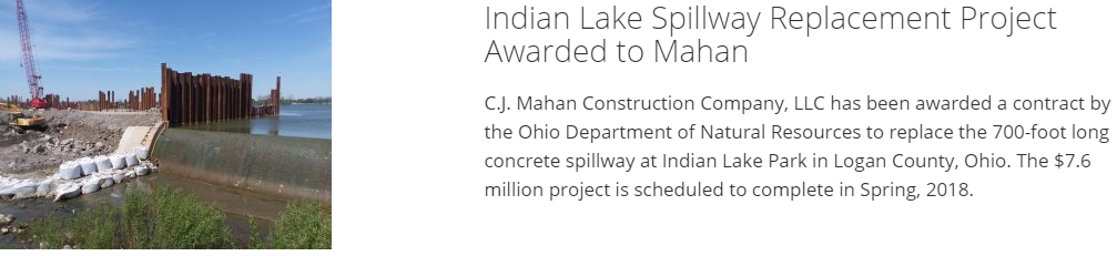
Indian Lake Spillway and Miami & Erie Canal Feeder

(Satellite, 52+ photos)

Jack Hines posted
4000 working at Indian Lake spillway, Russell's Point, Oh.
Keith Moore I ran there 40 ton grove there for four months Reese is the operator on the 4000 does a great job of it solid dude for sure

It appears the spillway designers tried to ensure that only a small stream of water would go over the spillway because a long dam feeds water under a rather short bridge. With only a small stream over the dam, I would not think it would be a drowning machine. I wonder why it is being replaced with a V-shaped dam design. It looks like it needs to be replaced because of spalling on the dam's surface. And it does appear that the flow can get rather heavy even with its long length. So if you are going to build a new dam anyhow, it might as well be of a modern design. They are also installing erosion mats on the downstream side.

Satellite
When I saw how big Indian Lake is, more than a couple of miles wide, I wondered if it was built for the Miami and Erie Canal. The following map confirms that Indian Lake was a summit lake for the canal. That is, it is a lake built near the summit of the canal to store water for the canal to supply water during dry seasons. There should have been a gate structure to let water out when the water level was below the spillway to feed the canal. They must have removed the gate structure since the canal feeder function is now obsolete.
ODNR

cjmahan

cjmahan

cjmahan
[Unfortunately, the video link is broken. But you can play the video in the little window. It is timelapsed and caught several overflow events. I took a screenshot during one of them.]

Indian Lake Aerials by Kevin Campbell posted

Indian Lake Aerials by Kevin Campbell posted five photos with the comment: "Spillway Spillin’ (02.25.26)."
1

2

3

4

5


Cannelton Locks, Dam and Hydro Power

(Satellite)

Paul Osterhus, Jul 2018, cropped
[The lower pool looks high, so why aren't the gates up?]
According to USACE, the upper and lower pools are normally 383' and 358', giving a drop of 25'. "The project was approved as a replacement for existing Locks and Dam 43, 44, and 45 on January 27, 1960."

A 15-barge tow showing off the 1200' capacity of the Ohio River locks.
Satellite

Michael Haynes posted
Michael Haynes Cannelton locks & dam. 2 4000’s @ 125 tons, 2 39A’s, 2 71-B’s, a 54-B, a steam derrick boat and 2 Clyde Whirley gantry’s. That’s all it took to build locks and dams
Darrin Liegel Michael Haynes Didn’t know they made a 4000 rated@ 125 ton
John George 125 ton 4000’s were non W’s. I think there were 125 ton vicons. The 125 were 24’ long and 17’ wide. W’s were 24’ long and 21’ wide

Bryan Burton Photography posted
The Tina Bowling in the Cannelton Locks and Dam on the Ohio River. 07/2024
Mark Heslep: The deepest part of the Ohio is a 160 ft. scour hole about a mile below the dam. I'm glad we got past it before the sternwheeler sunk four years ago at mm 740.2. The boat's still on the bottom...
Robert Dawson: nice bit of coal thats being burnt in the USA for cheap electric and helping achieve net zero for the UK who are not allowed to use it, .
Faron Davis: I wonder what the water difference is on each side of the locks in feet.
Mark Heslep: Faron Davis. 24-26 feet give or take a few. The normal navigation pools behind the dams are maintained at 24 feet. [Other dams have a different headwater depth so that the depth is 9' at the tailwater of the next upstream dam.] Without them a free flowing river wouldn't support commercial traffic. The river is dropping in elevation from its beginning; the dams keep the water from 'running downhill', so to speak. Lockmasters are regularly evaluated on their water management and conservation, especially during drought conditions.

Robert Flannery posted, cropped
Dredge Bill Holman Canelton Lock and Dam Ohio River 2021
Ryan Sturma: Not even a photo credit. For shame...
Robert Flannery: Ryan Sturma yes you took the photo
[The dredge is on the left in the lock channel and the pipeline moves the slurry to the discharge in the
of the river.]
 
Michael Gore posted four photos with the comment: "We ate lunch today at the Riverview Restaurant which is on the high hill above Hancock Bend at OR mm. 722.5 just upriver from Hawesville, KY and overlooks Cannelton LD. The TENNESSEE (Amherst Madison, Inc.) with 15 locked down and is seen just clear of the long wall and meeting the JOSEPH PATRICK ECKSTEIN (Marquette Transportation Co.) with 2 heading up to the little chamber. The CAPT. KIRBY DUPUIS (Florida Marine Transporters) with 15 was on the upper longwall waiting for the pit to be turned around. The last photo shows the historical plaque dedicated to Capt. John W. Cannon which is next to the restaurant. I have always said that when you shove out of Cannelton n/b, it's like you're entering a completely different land and geography."
Tom Struve: Passed the Joseph Patrick Ekstein with that same tow upbound on the Lower. What in the world can be in those two barges to make that long trip with only those two barges? Mystery?????????
Michael Gore: Tom Struve Checked the USACE Lock Queue Report and the JPE locked up at McAlpine ending at 0830 ET this morning with 2 barges. Perhaps a speed tow with mystery cargo needed somewhere quickly!
Tony Werner: We sure looked closer together.than what the picture shows, I was at the helm of the M/V Tennessee when the picture was taken. Thank you sir.
Michael Gore: Tony Werner You are welcome! Small world!
1
lll
2

3

4

The cutter head of the Bill Holman.
USACE via trendsmap

Street View, Oct 2008
It appears the hydropower plant has yet to be built. I added Global Earth views below.

Street View

Street View

Ryan Burleson posted three photos with the comment: "Found these working at the Cannelton locks and dam. I'm fixing the RT in the bottom of the lock."
1

2
Mark Goodrich 39w.Ben StalveyGroup Admin Sure looks nice yet

3
Jack Hines Long walk for tools, isn't it!
Ryan Burleson Yes sir. About 5 stories of stairs and the length of a lock twice. That's just one way. I did a lot work with 1 pair of pliers. Lol
Jack Hines Ryan Burleson I'll bet, I always carried a pair of channel lock in my back pocket.

When I looked at the satellite image, I noticed this dam has already had a 3-bulb, 88-MW hydro power plant added on the side. This reminded me to check the status of the hydro power plant being built next to the Smithland Dam. The 2017 satellite image has not changed from the one copied in the posting. The Bing image is old enough to show the Cannelton plant still being constructed.

Bing Satellite
Now that I've learned how to use Global Earth as a time machine, I can include more views of the construction. It is also interesting to see the different river flows and tow activity.
Oct 2008

Aug 2010
I'm surprised how much debris has been allowed to build up against the gates. I assume it is too risky to take construction equipment on a barge that close to the dam during a high river flow. In addition to the travelling gantry on top the dam, it appears they need a travelling crane that would allow them to lift debris up and over the dam.  Submersible Parker gates are normally used to allow ice to flow through the dam. But they should also be able to allow debris to flow through the dam since these are 100' gates. 

Oct 2013

Jun 2016

Jun 2026. The Parker gates are open enough to allow the river's flow through but are closed enough to keep a 9' channel in the dam's pool.
Facebook Reel