Wednesday, December 27, 2017

UP/C&NW 1913 Lattice and Schmidgall Road Bridges over Mackinaw River

C&NW: (Archived Bridge Hunter, Bridge Hunter; no Historic Bridges, John Marvig, Satellite)
Road: (Archived Bridge Hunter; Bridge Hunter; Satellite)
Hal Collins shared a Flickr 1996 Photo of a CNW and two UP locomotives on the bridge and the river is almost to the top of the pier.
Dennis DeBruler I'm surprised that a lattice truss bridge is still in Class I service.

Schmidgall Road Bridge


Lois Munson posted
Schmidgall Road Bridge east of Mackinaw, Illinois
Spans Mackinaw River
I cannot find what year it was built.
Does anyone know ????
Tazewell County Illinois
Art Suckewer: Stylistically, it looks like an early 1880s Wrought Iron Bridge Co. bridge (style of portal) but I'm guessing it's a different builder - the remaining approach truss doesn't look like WIBCo. We can probably figure out the actual builder and date with a bit of effort What happened to one of the two approach spans? It looks like the floor beam is still there but some blocks are beneath it to keep the deck from folding under load. Otherwise, it looks to be in great shape! Whoever owns it is lucky that it's made of old school wrought iron rather than steel!

Thank goodness for BridgeHunter. I would have never found the satellite location if it wasn't for BridgeHunter.

2012 photo by Steve Conro via ArchivedBridgeHunter

Obviously, the bridge is pin connected.
2012 photo by Steve Conro via BridgeHunter

2012 photo by Steve Conro via BridgeHunter


Tuesday, December 26, 2017

Ross's Landing in Chattanooga, TN

Along the River Walk near Walnut Street Bridge is a sign about Ross's Landing.


 A closeup of the sign:

A transcription of this sign:

Large text: Ross's Landing: River Crossing and Port

Medium text: Once a ferry crossing connecting the worlds of the Native American Cherokee and the Anglo-American settler, Ross's Landing was the heart of the town of Chattanooga.

Small text:
This place was once a river crossing known as Ross's Landing. John Ross, an individual of mixed Scottish and Cherokee heritage, operated a ferry crossing and trading post near this spot from 1815 to 1826. An elected chief among the Cherokee, John Ross and his Native American people were forced from these lands in 1838 under the terms of the Treaty of New Echota.

In 1839, the Anglo-American settlers at Ross's Landing created a town that they named Chattanooga. A swing ferry anchored at the foot of Maclellan Island swiveled on the Tennessee River from shore to shore, connecting the northern portion of Hamilton County to its principle town.

A key port on the upper Tennessee River, Ross's Landing had also been selected as the northern terminus of the Western and Atlantic Railroad. The W&A originated at the railhead that would become Atlanta, Georgia. As a commercial riverport with rail connections, Chattanooga assumed new prominence among the cities of Tennessee.

By 1835, regularly scheduled steamboat service from Bridgeport, Alabama to Knoxville, Tennessee was a reality; these vessels distributed manufactured goods and collected agricultural products for shipment by water and rail. By 1848, Chattanooga would collect more than 10,000 bales of cotton a year, much of this valuable cargo being stacked along the riverbank and streets adjoining the wharf.

Bulk commidities such as cotton and corn were frequently shipped by flatboat to Ross's Landing where the cargo was carted to the railyards south of town and the boat was broken up for lumber. In later years, the wharf at Ross's Landing would be crowded with the timber cut from the headwaters of the Tennessee and rafted down to the sawmills built along the banks of the river.

Navigation of the river in the 1800's was not without hazards. Below Chattanooga were a series of dangerous shoals and narrows. In the dry summer months, the river level would frequently be too low for passage of even shallow-draft steamboats, making loss of life and cargoes common on the Tennessee.

Walnut Street Bridge over Tennessee River in Chattanooga, TN

(Bridge Hunter, Historic Bridges, HAER, 3D Satellite)
This bridge is now a trail.
Posted December 18, 2014, by Alan Walker (awalker1829 [at] yahoo [dot] com)This bridge was found unsafe for vehicular traffic and stood abandoned and unused for more than twenty years, despite repeated petitions by the Coast Guard to either repair it or remove it. Community interest in preserving this bridge led the City of Chattanooga to include the restoration of the bridge as a key part of the Tennessee Riverpark. Most folks today do not realize how close we came to losing this bridge. [Bridge Hunter]
The text on an interpretive sign describing the 1867 Great Flood also describes how this bridge was built.
20171217,18 9025 +30+30, western elevation framed by the Market Street Bridge
The poles on the right in the above photo hold a dock that can be used only by boats that are tieing up along the river front. That is, there is a gate because the general public, including fisherman, are not allowed on the dock. The height of the poles shows how high the river might get when the Chattanooga Dam opens up its gates.

Market Street and Walnut Street Bridges, Boston Public Library on Flickr, License: Creative Commons Attribution (CC BY)

This looks like it is the Walnut Street Bridge.
Maher Maha posted
Tennessee River Frozen
 Chattanooga 
January 1940
George M. Pope: I don’t know what year, but when I was a kid I heard that the Tennessee River froze so solid at Knoxville that some guy drove a Model T Ford across it on the ice. Sounds far-fetched, but that’s what I heard!
Paul Wade: George M. Pope It's true. I was 10 y/o back then. They tied log poles along the sides of their car to keep it from sinking in case the ice broke but I never heard of one that sunk. I don't remember how many miles but the Cumberland River froze for miles through middle TN.
Chris Elledge: George M. Pope I actually seen pictures of that a few years back. There was three vehicles out there and half a dozen people.
Cliff Clark: My stepdad dad ran a ice house in chatt, and in early 1900 cut there ice blocks from the river, today because of tva nuclear plants it never gets cold enough to freeze.
Eric Holloway: It was actually 1937...but who's counting....
Lloyd Scott Hardin shared

Crista Barbaka posted
The Walnut Street bridge was built in 1890 by the Smith Bridge Company, becoming the first non-militry bridge in Chattanooga. It was designed by Edwin Thatcher in a style known as Pennsylvania Truss. The bridge initially served horse-drawn wagons and pedestrians and was significant in increasing access to the north shore.
In 1978 the bridge was closed due to safety concerns of structural integrity. It was planned to be demolished but thankfully restoration was begun in 1991. Two years later it was re-opened to foot traffic.

This part of Chattanooga on the south side of the river is on a bluff, so the former street bridge begins with spans.
The north side is a flood plain, so there is a significant trestle between the bridge spans and Frazier Avenue.
I don't know if the handrails have been preserved all these years or if they were restored, but either way, it is nice to see the more ornate handrails that were used in the 19th Century.

The purpose of this photo is to capture the cables that were added at some point to provide more tension strength for the tie-bar members. I have to confess that my wife is the one that first caught that detail.

The roof line near the left of the photo is on the aquarium.

Note the "kinda snowflake" lights. ("kinda" because snowflakes have six points instead of eight.) I wonder if these are up year round or if they are up because we were visiting during the holiday season. They are a reminder that we are further south than the Chicago area because I don't think most Chicagoans think snowflakes are special enough to be an inspiration for a decoration.
The bridge had tie-rods with turnbuckles as well as tie-bars. Note the medallions in the lower-left corner. (Unfortunately, one is missing already.) They obviously had a fund raiser to preserve the bridge because I assume the name on each medallion was that of a donor. There were a lot of medallions along both crosswalks.
My wife and daughter provide scale. I wonder if the bridge was one way and switched directions according to rush hour flow. Those are horse&buggy width lanes. Certainly not the Federal Standard 12-foot lanes that today's kids are used to driving in. You would definitely not want to text while driving on this bridge. Now that I'm aware of them, the cables to reinforce the tie-bars are obvious in this photo.

A photo dump of the other photos I took while I crossed the bridge.


This view to the north catches the river trail as it descends from the bluff down to river level. It reminds me of that windy street in San Francisco. The Hunter Museum of American Art is the building on the bluff.
I was playing peek-a-boo with the clouds.
On the way back, I noticed the Hunter Museum had an older building as part of their complex.
And now a photo dump of the other pictures I took while walking along the river front. We first walked away from the bridge, and then we walked back to climb some steps up to the bridge's deck.

I transcribed this sign in Ross's Landing.


It appears that some of the stones have been replaced. It appears the height of the piers was increased with an extension. There was probably a predecessor bridge that was a deck truss. When they switched to a through truss, the height of the old deck truss had to be replaced by the pier extension. Switching from a deck to a through truss significantly increased the height of boats that could go under the bridge.

Monday, December 25, 2017

Panama City, FL, 23rd Street Flyover and DuPont Bridge Replacement

DuPont Bridge: (Satellite)

I'm saving the satellite image of the flyover location because it will change.
Satellite

The project is elevating US-98 and using ramps to connect to the roads that intersect with it.
nwflroads
It started by building a new US-98 just south of the existing road. The detour itself had to cost a pretty penny. The estimated cost of the project is $68m.

Screenshot (source)

Note that this post is labeled with both bridgeGirderConcrete and bridgeGirderSteel. As the following cropped screenshot from the above video shows, they use both.
-1:08
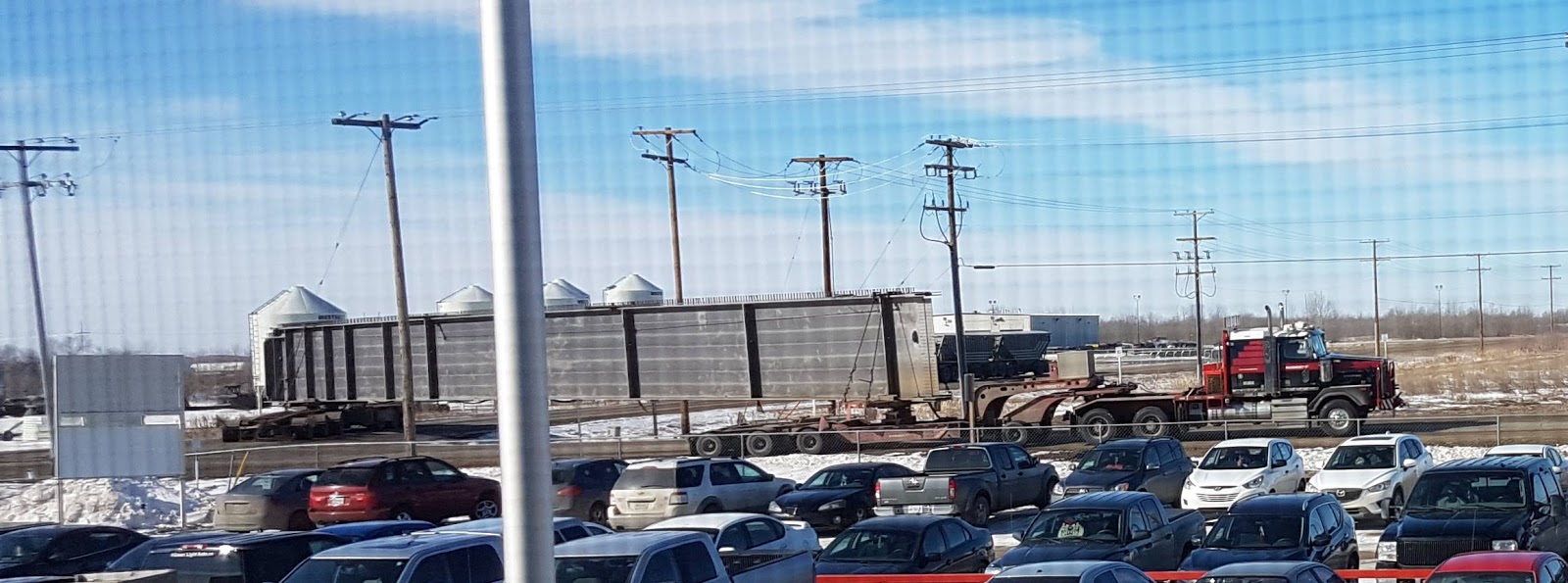
With modern cranes, the size of a girder is limited by what can be transported to the site. Notice below that many tires are used to distribute the weight across the road. States have restrictions on how many pounds an axle can carry to avoid damage to roads. One advantage of such as long load, is it spreads out the load on bridges. The girder is attached to turrets on each of the dollies so that it can turn when the truck goes around corners. Typically, the rear dolly is independently steered.
FDOT from Instagram
  • my23rdstreetflyoverSteel tub girders for U.S. 98 permanent bridge construction are being delivered to the 23rd Street Flyover project. Each girder weighs approximately 127,000 pounds.
Here is a photo from a different project that shows the rear dolly just starting to turn while the front dolly has completed the turn.
From a Facebook collection of photos showing the transport of a bridge beam.
I have concluded that they use concrete girders for spans shorter than the legal transport length. And they use steel girders for spans that are longer than the allowable transport length because they can temporarily hold beams in place and make field joints. The first photo shows the first beams temporarily held in place, and the second photo shows them lifting another girder that will be joined to the girder on the temporary shoring.
FDOT from Instagram
  • my23rdstreetflyoverThe steel girder beams used in the construction of the 23rd Street Flyover support the bridge deck (roadway surface) and are responsible for transferring the load down to the foundation. Material type, shape and weight all affect how much load a girder beam can carry.
FDOT from Instagram
  • my23rdstreetflyoverContractors set steel girder beams atop hammerhead pier caps and temporary shoring towers during the construction of the eastbound U.S. 98 bridge. Each steel beam weighs approximately 127,000 pounds.
Below we learn that the concrete beams are about 135' long.
FDOT from Instagram
  • my23rdstreetflyoverEach concrete FL U-Beam east of 23rd Street is approximately 135 feet in length. The length varies depending on the specific bridge pier span they are being set on.

(new window)


DuPont Bridge


Massman Construction Co. posted four photos with the comment: "Massman is at work in Panama City, Florida on the DuPont Bridge Replacement with our industry partner Scott Bridge Company. Our high-capacity floating cranes have finished conducting a test pile program and our team is now installing permanent piling in advance of pier construction. This test program is designed to confirm pile capacities, confirm soil conditions, and obtain information used in the final design of the production piles and create the driving criteria. The DuPont Bridge replacement project is administered by Florida Department of Transportation."
1

2

3

4

Scott Bridge Company posted five photos with the comment:
Big upgrades on the water!
Scott Bridge Company has officially refurbished their Ringer Crane barge, representing a significant step forward with the replacement of the friction Manitowoc 4100 with a modern hydraulic Lampson Millennium 4100 SII crane.
Why the switch to hydraulic? The benefits are substantial:
    •    Improved precision and control – Hydraulic systems deliver smoother, more responsive movements, critical for heavy lifts over water.
    •    Increased efficiency – Faster setup, easier operation, and reduced downtime translate directly to higher productivity.
    •    Enhanced safety and reliability – Modern hydraulic controls, monitoring systems, and redundancies improve jobsite safety and operator confidence.
    •    Lower maintenance demands – Fewer wear components compared to friction systems mean less downtime and more consistent performance.
This upgrade positions Scott Bridge Company with a more capable, efficient, and future-ready marine lifting platform, ready to take on the next generation of complex infrastructure work.
1

2

3

4

5


Sunday, December 24, 2017

Former US-52 Bridge Replacement over Wabash River near Lafayette, IN

(Bridge Hunter, 3D Satellite)
I added "former" to US-52 because a new US-52+US-231 was built on the west side of town and this road is now the Sagamore Parkway.

I saved this 3D Satellite image since it will be changing because they are replacing the truss bridge with a girder bridge.
3D Satellite
Rob Shellhamer posted six photos with the comment: "Some pics my son took the other day. US-52 crossing the Wabash River in Lafayette, IN."
Dennis DeBruler It looks like they are replacing the truss bridge with a girder bridge. The girders are a pre-stressed concrete bulb tee design. It also looks like the traffic jams will continue during the Winter months. I wonder if they will get it done before the flood season or if they are crossing their fingers that there will be no floods next year. https://www.google.com/.../@40.4502126,-86.../data=!3m1!1e3

Rob Shellhamer Yes, they demolished the girder bridge in 2016. Apparently, they've already had some delays for flooding.

1

2
Dennis DeBruler This is an excellent view contrasting the thickness of a pre-stressed concrete bulb design girder with a steel girder. Photos taken while the 1936 truss was still standing provide a comparison between truss and the 1969 steel girder design. http://industrialscenery.blogspot.com/.../reinforced-and...

Dennis DeBruler Being able to haul a complete girder next to its final destination must greatly reduce the cost of construction. The contract for this bridge is just $13.4m. And the spans are extra wide to provide for a separate 10' multi-use path on the south side. The original estimate for the replacement was $16m.

3

4

5
Dennis DeBruler I didn't notice the truck and the rear-dolly until I looked again. They would have to shut down US-52 completely for this operation. I assume this is the longest span, and Bridge Hunter indicates it is 150'.

6
Ben StalveyGroup Admin 999
Bridge Hunter says it was eligible for the National Register of Historic Places. Evidently Indiana made sure they got it tore down before it got registered.
INDOT
The new bridge has a right shoulder almost as wide as a regular lane and has a 10' multi-use lane.

Given that they built new piers, it was probably the piers, not the trusses, that was failing. That is the case with I-64 over the Wabash. I guessed wrong, I found the following comments on Bridge Hunter: "Posted August 24, 2008, by Jeff Wieland: The east bound bridge, which dates to the 1930's, is now scheduled for replacement in 2016. There seems to some sort of paranoia about the resemblance between this bridge and the I-35W bridge in Minnesota." "Posted July 12, 2016, by Jeff Wieland  The eastbound bridge was demolished today." But I was not totally wrong, Ugly Bridges indicates the piers are scoured and that action is required. That explains why they tore the piers down as well.

The truss bridge was rehabilitated in 1985. [Bridge Hunter] A million dollars was spent on 2010 for more repairs. [jsengr] So maybe it had become a money sink and replacement will be cheaper.

I was going to use Street View to try to catch a view of the old truss, but I'm too late. The view from atop the other span has the old bridge gone and they are starting to build the crane's walkway into the river. I learned after more research that they are actually rebuilding the walkway. They must have had a recent flood.
Street View, Aug 2017
They got some piers built on the east side before a flood stopped the work.
Street View, Aug 2017
Going down to IN-43, the work appears to be further long even though the image capture is still Aug 2017. This shows that they can rather quickly rebuild the walkways.
Street View, Aug 2017
Bing doesn't seem to have any street views in this area. I expected that they would have at least done US-52.

(new window)   We learned just a couple of days ago that some now use the term "energetic felling" for a bridge demolition with explosives. Note that the walkways for cranes were well formed during the 2016 bridge removal.