Wednesday, October 25, 2017

Robert Street Bridge over Mississippi in St. Paul, MN

(Bridge Hunter, Historic Bridges, John Weeks3D Satellite)

The content concerning the UP/C&NW/CGW lift bridge has been moved to here. Many of those photos include this bridge in the background.

John A. Weeks III, downstream (eastern) elevation from the south bank riverwalk

John A. Weeks III
The photo above shows a good view of the main span rainbow arch. Notice that there is steel work under the bridge deck to help support the roadway. Also notice the Great Western railroad lift bridge behind the Robert Street Bridge. The railroad bridge was built many years before the Robert Street Bridge.

 Both road and railroad truss bridges were built in 1885.
Journal of the Western Society of Engineers, Volume 8, p 438
The draw is operated by steam.

Dan Ashbach posted three photos with the comment:
Robert Street Bridge.
The first bridge here opened in 1886 and served until the early 1920s, when a higher bridge was required to accommodate a raised railroad platform at St. Paul Union Depot. Designed by Toltz, King and Day of St. Paul, the bridge is a type known as a “rainbow arch,” so named because the arches of the main span raise above the roadway like, well, rainbows. This form was dictated by the demands of the site: the bridge’s roadway needed to reach Kellogg Mall at grade but also had to clear the elevated tracks of the adjacent Great Western Lift Bridge (1913) and be high enough to permit the passage of riverboats. The bridge, which has art deco touches, was rebuilt in 1989 by the same firm, now known as TKDA, that had designed it 65 years earlier.
Tom Lyman shared
1

2

3

Historic Bridges
ca. 1895 Photo of Previous Bridge
Source: Minneapolis Photo Collection of Hennepin County Library

Street View

The railroad bridge was replaced in 1913 and the road bridge was replaced in 1926. The road bridge was rehabilitated in 1989 and added to the National Register of Historic Places. The concrete pony arch [BridgeHunter] or rainbow arch [HistoricBridges, JohnWeeks] span (navigation channel span) is 264'. The two pony arches are not reinforced with rebar. Instead, a steel arch was built, which was then encased by concrete. [HistoricBridges, JohnWeeks, BridgeHunter]
One feature of the bridge is that it appears to fit so well to its surroundings. Perhaps the reason for that is that the bridge was so difficult to fit around all the obstacles at that location. This includes having to be high enough for river boat traffic, low enough to meet the low grade south of the river without having too steep of grade (as required by street cars), it has to be high enough for trains to pass under, yet it had to match the height of Kellogg Blvd. The result is that the bridge design was dictated by each of these constraints. [JohnWeeks]

Kevin Piper posted
Two SOO GP30's cross the Mississippi River at St. Paul, MN, on 8-16-74. PHOTOGRAPHER UNKNOWN

John Harker posted
Moments after departing from St Paul Union Depot at 6:55 pm in August 1970, Milw train #5 the Morning Hiawatha was captured in this scene passing under the Robert Street Bridge. It was enroute to the Minneapolis station for a scheduled arrival at 7:20 pm. William J Brennan took this original Kodachrome slide which I scanned and edited for this image. Also, an image of his slide was published in the Morning Sun book, Milwaukee Road Through Passenger Service, Volume 2 by Greg Stout and John Schultz. John Harker collection

The river has been really low in Summer 2021. Plus this provides a view of the upstream side of the bridge.
Mary C Kennedy posted, cropped
Messy shoreline on the low Miss in downtown St Paul.

uslakes

BRC 100th Street Yard

(Satellite, the slightly diagonal yard in the center rather than the yard on the left)

Bob Lalich Flickr, Aug 1984
BRC 100th st Yard
BRC TR4 set switches Rail To Water near 100th St, 8-84.
The tracks in the upper-right corner of this diagram are the southern end of this yard.
William E Plut commented on a post
Bob Lalich Not much business for 100th St yard these days, is there?
William E Plut Bob Lalich it’s been pretty dead for a few years since the coal was shut down. Few industry jobs. Although new management is drumming up business. We have trains stored and passing through for now.
William E Plut From 112 to 106 BRC has two tracks that lead into 100st yard. Their is still properly that the belt owns south of that but the yard is over grown. I only leaned of it in the last few years.

Everything between 106 and 100st for the most part is belt property.
William E Plut I’ve heard stories of the old plants that use to be along the tracks. Steel, coke, fork lifts, coal was coming to a close around the time I started about 10 years ago. There is rumors of a stone company taking the place of the old coal location. Very possible 100st gets some life back in it.
The yellow rectangle marks the yard office. According to the shadow, it looked more like a tower.
1938 Aerial Photo

Arturo Gross Flickr photo is the first of five photos with the comment "BRC Alco C424 601 and mate 603 pull into 100th St. Yard on Chicago's southeast side with loads for KCBX rail to water terminal May 1996." The Alcos are belching smoke. Especially in this photo. When he posted this Flickr link in Facebook, William L. Brushaber commented that Arturo took the photos from the south end of the yard below 104th Street from Muskegon Avenue. Arturo commented:
Dennis DeBruler If you can get your hands on the book "The Pennsy in Chicago" by Ed DeRuin, it's a great resource for figuring out what is going on rail wise on the far south/southeast side as well as Northwest Indiana. Obviously not all the tracks are former PRR, but there are so many PRR lines that the coverage really explains alot. In this case a PRR line called the Cummings Branch [my link because I researched the pennsyrr link given below] also ran right next to the BRC yard. Many of the same track diagrams that are in the book are also available on this website, but it's a little harder to get the big picture than the book... http://broadway.pennsyrr.com/Rail/Prr/Maps/index.html

2015 Street View
2014 Street View
John DeWit Woodlock II posted
BRC 511,505 @ 100th Street Yard-Chicago,IL 19 APR 97
[The cow and calf unit must be at the south end of the yard.]
John DeWit Woodlock II It was indeed located at the south end of the yard, not quite as far as 104th Street if I remember correctly.
John DeWit Woodlock II posted
BRC 604,600 @ 100th Street Yard-Chicago,IL 18 APR 97. My apologies for the soft focus.
[We are more in the middle of the yard looking south at the Railto Elevator]
John DeWit Woodlock II posted
BRC 605;UP 8034;7013 @ 100th Street Yard-Chicago,IL 22 APR 97.

John DeWit Woodlock II posted
BRC 605,601;UP 8034;7013 @ 100th Street Yard-Chicago,IL 22 APR 97.
[We are even further north because the Railto Elevator is in the distance on the left.]
John DeWit Woodlock II posted
BRC 605;KCBX 1872,1874 @ 100th Street Yard-Chicago,IL 22 MAY 97.
[Near the north end looking north because that is the approach to the Skyway in the background.]
Marty Gatton Screenshot
CRL operating OMLX 4200 and 1000 northbound through BRC’s 100th street yard
7am 6/27/19
Marty Gatton Someone in the know please advise...

Is the two track stretch these will run on called the Cummings branch? (Eventually through rock island junction and into the BRC South Chicago yard)Ean Kahn-Treras Marty Gatton No. That was the name given to the PRR branch that also followed the BRC down to Commercial Ave Yard.

The BRC timetable says this is the South Chicago District Industrial Lead. Rock Island Jct to 112th St.

Nick Hart posted
Chicago Rail Link time! The clouds were trying to spoil the party, but OMLX 4200 and 9469 managed to find the sun. Slowly making way to the yard near 104th Street in Chicago's south side, the pair of GP40-2LW's are in charge of interchange tonnage from Blue Island. 4200 wears sharp Hudson Bay paint, while the 9469 is still kicking in CN zebra paint.
November 11th, 2020
[That is the former General Mills plant on the right.]

Gary Pyke posted
Belt Railway of Chicago 237 a GP23ECO sits on the Southside of Chicago waiting for its next assignment.
Dennis DeBruler Ean Kahn-Treras It is always nice to learn about an industry that is still rail served. https://www.google.com/.../data=!3m1!1e3!4m5!3m4...

Luke Malin posted
Chicago Rail Link's transfer to Commercial Yard and back assembles its outgoing consist, utilizing BRC trackage for headroom. Once finished building, the CRL train will return to South Deering via its own trackage which parallels this line to the west. The tracks leading off to the right were the now defunct BRC rail-to-water transload. The bridge in the background is the Chicago Skyway. 7/18/21
Bob Lalich: Interesting shot! Let me see if I understand correctly. CRL pulls cars from the BRC in Commercial Ave Yard down this line as far as needed to clear what used to be called Rock Island Jct, then shoves back on their tracks to reach the switch to the old Rock Island Irondale Branch near Colfax Ave, correct?
Luke Malin: Bob Lalich Correct. They were actually starting to shove in this picture, this is the biggest train I've seen them take and thus the farthest I've ever seen them pull down these tracks.
Gavin Robey
Since so many have already asked, below is a pin to the location. I myself am amazed at the size of the rail-to-water transload facility. What’s the history there? How long been disused?
Dropped pin
Dennis DeBruler
Gavin Robey I think the rail-to-water facility quit doing coal when the Midwest power plants switched from Illinois Basin Coal to Powder River Basin Coal. Then it did petcoke for a while. But they had trouble stopping dust from blowing off the piles, so they gave that up.
Bob Lalich
Gavin Robey - going back to the early 20th century, there was a coal facility at this location operated by the Lehigh Valley Coal Co. Rail To Water Transfer Corp was established in the 1940s by 27 coal companies, according to a Chicago Tribune report. Business grew rapidly into the 1960s and the facility was upgraded several times. At that time, the facility handled coal for Great Lakes power plants, along with some metallurgical coal. Business began to decline in the 1970s due to power plants switching to low sulfur coal. I don't have a date but sometime in the 1990s RTW sold the facility to KCBX. In later years of operation, petcoke was the only commodity handled.
Trains magazine ran an excellent article about the BRC in the Sept 1966 issue, which included a sidebar story about RTW. The article is available as a download from Kalmbach.


Arturo Gross Flickr 1995 photo

Arturo Gross Flickr 1996 photo (source)  Mark Bilecki Sr. They were brand new then.

Arutro Gross Flickr 1996 photo Smoking Alcos pull a train destined for KCBX rail-ro-water. (source)
Mark Bilecki Sr. Awesome! 603 is probably the smoker, as I remember it also belched flames at times too
Daniel Metzger Mark Bilecki Sr. I think those ALCo’s could smoke on command. It I recall there were crews who would smoke them up if they saw a photographer.
Dennis DeBruler Daniel Metzger I knew that steam locomotives can do that by pouring excessive coal onto the fire. It is standard practice now for exhibition steam train runs. I wonder how a diesel engine did that.

Tuesday, October 24, 2017

CREATE: B1 - Canadian Pacific Crossover Upgrades

Satellite
The Milwaukee Road had four tracks going past the Franklin Park station. When it went bankrupt, Metra bought the northern two tracks and we can see in this satellite image that they continue on to Chicago. Canadian Pacific bought the remaining tracks which includes Bensenville Yard and the southern two tracks past the station. As we can see from the satellite image, those two tracks turn south onto the Indiana Harbor Belt.

If you trace the two southern tracks westward, you have to go all the way through the yard to find a connection with the top two mainline tracks.

The B1 Project will add five crossovers and the associated signalling between Scott and Ruby so the 12 freight trains a day that go to the IHB can stay on the mainline (Metra) tracks until they are past the yard. "The schedule calls for completing construction of the project in 2019." [rtands]

The claimed benefits are:
This project will reduce the number of freight trains within the yard and reduce delays at nearby at-grade crossings. The potential for delay to Metra trains due to conflict with slow moving freight trains entering the yard will be reduced. [B1]
The first benefit (getting through trains out of the yard) means that CP, rather than federal tax payers, should be paying a significant share of the costs. The other two benefits do benefit the public. But they assume that a freight train can travel on that curve at the connector to IHB significantly faster than it can travel through the yard. I have yet to see a train go fast on the IHB. I should get videos now of trains travelling past Ruby Street to record their speeds so that I can compare it to their speeds after the project is done.

Oh by the way, this project also includes: "Install another crossover between the IHB and CN tracks" [B1] In this case [rtands] provides more information: "In addition, another crossover will be installed between the IHB and Canadian National tracks between Chestnut Avenue and Grand Avenue." That would allow CP trains to run on CN tracks through the residential area of River Forest. Since CN bought the EJ&E, CN hasn't used this former SOO/Wisconsin Central track in years. Supposedly CN is keeping that track intact for "emergency alternative routing." I notice that the Benefits Section of the project description avoids describing the benefit of this crossover. Is money being spent on that crossover for emergency routing or are the residents of River Forest going to have their property values reduced after 2019 because of train noise? (I just discovered that Google road map doesn't even show this route.) Looking at a street crossing, I don't think the crossing gates meet the requirements for a quite zone. So this area will be like Macomb, IL, where the horn is always blowing as a train goes through town. (A daughter used to live in Macomb.)


Monday, October 23, 2017

BRC: Belt Railway Company of Chicago Overview

(Shortlines)  (source)
Dennis DeBruler I've noticed that their herald is still on their bridge over I-290, https://www.google.com/.../data=!3m6!1e1!3m4!1sEzO5O...
Paul Schlichting Because that is there main line that connect to the CPRS (former MILW)

20140906 0114 view from the west side of Cicero Ave. Bridge
The Belt Railway Company of Chicago is the largest intermediate switching terminal railroad in the United States. It interchanges with every railroad serving the Chicago rail hub and serves about 100 industries. It has 28 miles of mainline track and more than 300 miles of switching tracks. Their main yard, Clearing Yard, already has its own post. Their web site has a nice introduction and history and a timeline.

The C&WI was formed in 1882 by John B. Brown. In 1883, "five major railroads; Louisville, New Albany and Chicago Railway [Monon]; Chicago and Atlantic Railway [Erie}; Chicago and Eastern Illinois Railroad [C&EI]; Wabash, St. Louis and Pacific Railway [Wabash} and the Chicago and Grand Trunk Railway [GTW]; signed leases to use Belt Railway’s tracks and terminal." In 1898, BRC was created from the freight operations of the C&WI. Seven additional railroads bought stock in the BRC.


Dennis DeBruler commented on a post
The C&WI was charted in 1879 by John B. Brown as the first terminal line in Chicago. Originally the C&WI focused on passenger service to Dearborn. But in 1881 Brown charted the "Belt Division, C&WI." And the passenger oriented part of the C&WI became the "Terminal Division, C&WI." A new belt route that went West along the Wabash right-of-way and then North a few blocks east of Cicero Ave. was completed in Aug, 1883. During this construction on Nov 22, 1881, the "Belt Division, C&WI" became the "Belt Railway Company of Chicago." BRC also built routes to, and along, the Calumet River.
Meanwhile, A.B. Stickney created the Chicago Union Transfer Railway in 1889 as Chicago's primary classification yard that would be used by all the belt lines, and thus all of the Chicago railroads. It was a large loop of tracks in which railroads would be assigned radial tracks. (See attached image.) A train could then efficiently go around the loop dropping off and picking up cars from several different railroads. But what got built by 1902 was a hump yard, one of the first of its type. But the line-haul railroads did not want to pay extra to have their cars classified so the yard closed after just a month. However, as congestion in Chicago grew, nine (another source says seven) railroads joined the original five owners in 1912 and bought into ownership of the BRC as part of the Belt Operating Agreement. This new ownership also acquired the Clearing Yard of the Chicago Union Transfer Railway. The agreement was successful enough that the capacity of the yard was increased from 5,000 cars/day in 1902 to 10,000 cars/day in 1914. And the branch that left Clearing on the west end and U-turned to head East along the north side of the yard to its mainline was built. (This was the route that used to go through the middle of what became Midway Airport. That route has obviously since been moved north of the airport.)
Because of mergers and the general decline of carload freight after the Interstate highway system was built, Clearing was practically empty by 1990. But new management revived it. Now, many of the Chicago railroads have converted their major classification yards to intermodal yards and their merchandise trains go directly to Clearing or IHB's Blue Island. Now BRC "is the largest intermediate switching terminal railroad in the United States." So Stickney's vision was more than a century ahead of its time.
https://www.american-rails.com/brc.html
http://www2.beltrailway.com/about-2/
David Daruszka posted the image for Stickney's circular plan.

The map on this page shows both divisions.
https://www.american-rails.com/cwi.html...

1889 Chicago Quadrangle @ 1:62,500

ChicagoRailFan has more details including a list of mileposts, a track diagram, and links to interlocking towers and track elevation ordinances.


BBC Show Announcement (source)
BRC's photo gallery has steam locomotives and maps as well as pictures of their current locomotives.

Viral Media posted
Belt Railway of Chicago Map
The Belt Railway has over 300 miles of yard tracks and 28 miles of mainline that connect with every railroad in Chicago. Owner lines and other railroads bring trains to the BRC Clearing Yard for interchange.  The heart of the yard is the wicket-shaped tower straddles the hump.  The tower controls the switches and retarders of the two classification yards. Operating much like a post office, computerized controls allow the hump tower to classify 8,400 rail cars per day.  The Clearing Yard separates, sorts, and re-blocks freight cars into trains for cross-country departure. 
The founding company of the BRC was the Chicago & Western Indiana Railroad, chartered in 1882. A series of connecting railroads was constructed over four years that formed a “belt line” which linked every major railroad in Chicago and also served many industries. Five railroads originally executed leases to use the tracks and terminal as tenants – Louisville, New Albany & Chicago Railway, Chicago & Atlantic Railway, Chicago & Eastern Illinois Railroad, Wabash, St. Louis & Pacific Railway, and Chicago & Grand Trunk Railway. By 1910, seven more railroads had joined. 
After a series of mergers and bankruptcies, the Belt is now owned by six Class I railroads — BNSF Railway, Canadian National Railway, Canadian Pacific Railway, CSX Transportation, Norfolk Southern Railway, and Union Pacific Railroad. Each of the owner railroads utilizes the BRC switching and interchange facilities. 
The Clearing Yard is located on the boundary between Chicago and Bedford Park, Illinois, just south of Chicago Midway Airport. The BRC also provides rail terminal services to approximately 100 area industries. 
Richard Fiedler shared
Richard Fiedler shared

BRC
The photo gallery also has a more detailed map with mile posts and street names on the sides. But that map is dated because it still shows Conrail tracks.

Brian Morgan comment in Ed's posting
[I wish the text was readable. I saved it because some of the trackage right lines were new to me.]

This is slightly different and it has readable text.
Bill Molony posted

David Daruszka enhanced a map posted by Bill Molony
This map of The Belt Railway of Chicago is from their 2000 annual report.

Dennis DeBruler posted
Alan Follett: What is that Chicago Transfer Railway line running east-west at about 4000 north? Was that actually built? If so, when did it operate?

Nick Hart posted
The Belt Railway of Chicago's Clearing Yard is one of the biggest yards around. With constant action, the yard is 5.5 miles in length and houses over 250 miles worth of trackage. It's also one of the largest hump classification facilities in the US and on this sunny morning, we see BRC SD40-2's 300 and 310 preparing to shove their final car over the hump. A slug set can be seen going about its work on the other end of the tower as well. More than 8,400 cars a day and between 40 and 50 miles worth of consists on a daily basis at the hump. Think about that for a minute.
With a roster full of classic EMD locomotives, you can't go wrong with the Belt. The strikingly nice paint scheme helps as well.
Bedford Park, IL
03-02-2021

post that has so much information I saved it in a raw format as two screenshots.
1

2

2 of 3 photos posted by the The Belt Railway Company of Chicago with the comment: "Chief of Police, Jerry Conoboy, met with Sonya Proctor, TSA's  Assistant Administrator of Surface Operations. Sonya is visiting from Washington DC and stopped by the BRC to learn about the operation and meet some of the team. Local TSA representatives Clay Yoksas (far left) and Paul Lloyd(far right) joined us, as well. Together, they toured the Belt's Command Center and received a briefing on operations from Terminal Manager, Bill Peck."
Richard Fiedler shared
1

2


Sunday, October 22, 2017

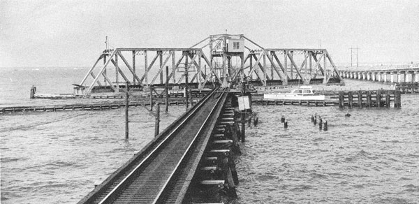
NS/Southern Bridge over Lake Pontchartrain

(Bridge Hunter; Satellite: South End, Movable SpanNorth End; Street View)

Steven J. Brown posted
Amtrak Crescent #20 accelerates away from the draw on the Lake Pontchartrain bridge leaving the New Orleans skyline behind at Slidell, Louisiana - January 23, 2022.
[I never noticed how tall the counterweight is until I saw this view.]
Gary Olden: When damaged by Katrina. Track pulled up and replaced by NS in 2 weeks to open up the road.

Norfolk Southern Corp posted
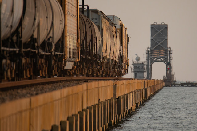
Pictured: Mixed freight train 141 crosses the 5.8 mile long bridge across Lake Pontchartrain between Slidell and New Orleans, La
 
Douglas Butler posted
Source of SOUTHERN Railfan NS Railroad Swing Bridge was replaced crossing the Lake Pontchartrain near New Orleans, LA.

Marty Bernard posted four images with the comment:
The Pass Manchac Bridge, Manchac, LA 
This ex-Illinois Central, now Canadian National lift bridge is at the western end of Lake Pontchartrain over Pass Manchac which connects Lake Pontchartrain to Lake Maurepas.  See the map.
The train is powered by IC SD40 6004 and repainted SD40-3 6263 on December 22, 2007.
David Barone: The CN runs 4 scheduled trains Q194/195, A419/420 plus coal and grain trains destined for the Baton Rouge Sub. Additionally Amtrak 58/59 in the late afternoon.
Marty Bernard shared
1

2

3

4


Norfolk Southern Corp posted
Alabama Division train 355 glides across Louisiana's Lake Pontchartrain, nearing New Orleans with mixed freight from Birmingham.
Norfolk Southern has a combined total of 1,830 employees in Alabama and Louisiana. #dyk
Learn more about NS: www.nscorp.com
Joey Wrenn This bridge is 5.8 miles long , it starts in Slidell to the North and goes to New Orleans, the water is on average 8-10 feet deep
"Arguably the longest railroad bridge in the United States." [BridgeHunter]

I copied the street view because it appears to have caught the bridge in motion. Or do they keep it in this partial position because it is high enough for most boats and low enough to reduce the wind load on the bridge mechanism and foundation?
Street View
The birds-eye view caught it in a closed position.

Birds-Eye View

Terry Redeker shared
Another week of Covid-19 & another bucket list shot!! While working some stores in South Mississippi & Eastern Louisiana & practicing my social distancing I realized I could start the day off by getting the shot of the Northbound Amtrak Crescent crossing Lake Pontchatrain from the North Shore near Slidell, Louisiana. The Sun burned through some hazy clouds just as the train arrived & the drone did well holding its ground in a pretty strong cross wind. Glad to check another shot off the list that I have wanted for a long time!! 4/9/2020

I Love Trains posted
Photo courtesy of Alfredo Guevara - Norfolk Southern crossing the Lake Pontchartrain bridge in New Orleans, Lousiana.
John Deasy: This is Southern Railway’s Southern Crescent, sometime before 2/01/1979. Look closely and you will see the dome car (second from rear) and the Amtrak transcontinental (NYP-NOL-LAX) sleeping car.

Bret Stringer posted
NS Pontchartrain Bridge Question: The other day an NS train asked for permission to cross the bridge, and the tender told him words to the effect of, "I'm working another bridge right now, I'll call you back when you're down and locked." So I assume the tender works the bridge remotely? So many questions! From where? Watching marine traffic via remote cameras? If anyone has info on how this set-up works, I'd love to hear it. Thanks!
Here's NS 131 heading out onto the bridge Friday, 26 May 2023.
Eric Adkins: Decatur, AL. It’s operated from the drawbridge up there. Decatur operates Northdraw, Jackson draw, and Warrior River Draw from there. So the operator is operating all 4 drawbridges at once. I used to work on this drawbridge on Lake Pontchartrain, the automation to Decatur is the reason I’m not now.
J.B. Rail Photo shared