A 1973 historic aerial not only shows the silos, but it shows a rather large ship being loaded. The elevator was replaced by the domes we see today by 1988.
 |
| Rod Sellers posted Currently working on a project to scan negatives of photos taken by Daily Calumet photographers in 1974. Can anyone identify the grain elevator in this photo and the location of the buildings in the foreground as well. Thanks. Tim Fishel Photo probably taken from daily cals rooftop. Bob Lalich The grain elevator was located at 93rd and the Calumet River. When built in the 50s and into the 60s, it was Continental Grain Co. When it exploded in 1977, it was Garvey. Dennis DeBruler Looking at a 1973 aerial, I see a good sized ship being loaded. There is also a railroad yard west of the elevator. What was, and is, the railroad that went along that section of the west side of the Calumet River? Bob Lalich The Rock Island and BRC had tracks that went along the west bank of the river from Rock Island Jct to a connection with the EJ&E at South Works. Both Rock Island and BRC served the elevator. The EJ&E used the tracks for transfer runs to the BRC at Commercial Ave. Sandra Brink The building by the 92nd Street Bridge on the north side was Nalco Chemical Co. My brother Dick worked there in the mid 60's. |
 |
| Michael Siola posted |
 |
| Tony Margis posted Now this is one big ship!!! 1973 Walter Gedwill 1977 when the elevator exploded and it was destroyed George Dosen We would empty a lot of the ships at Federal Marine and then they would go to Cargill or Garvey for outbound grain |
 |
| Jim Prrfan posted IH The International on the Calumet River. Late 60's. Jim PRRFan Photos. [The freighter is carrying iron ore to Wisconsin Steel. The gasometer was south of the Skyway.] |
I think Jim took the above photo from the 95th Street Bridge.
 |
| Street View, Oct 2022 |
The gasometer is in the lower-left corner and the grain elevator is near the top.
 |
| EarthExplorer: Sep 12, 1968 @ 17,491; ARB6830A0040500 |
 |
Rod Sellers posted
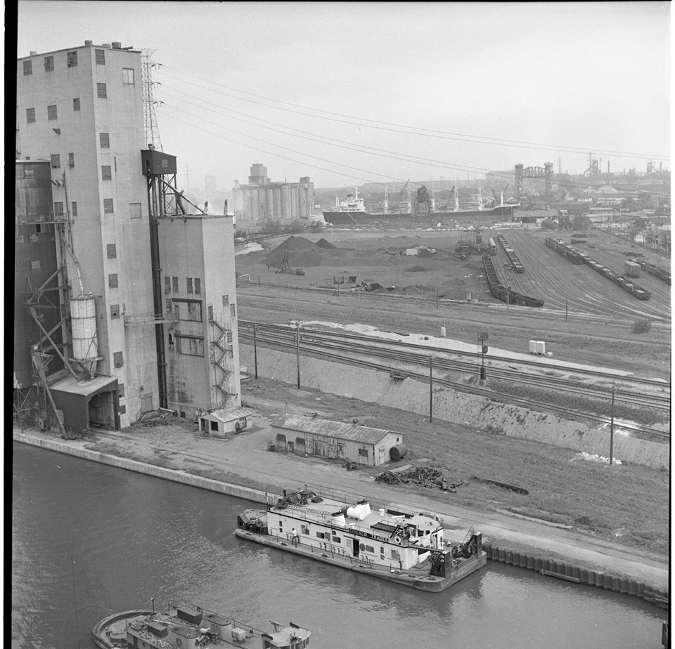
View from the Skyway by Daily Calumet photographer, June 5 1974 [It's the elevator in the background to the left of the ship. The one in the left foreground was the Norris Grain Elevator.]
|
The elevator is in the background of this photo. Note the blast furnaces of the US Steel South Works in the left background.
 |
| Donaldson Kippeant posted via Dennis DeBruler |
Attempts to Google more info found other elevators, but not this one.
Update: This land originally had the South Chicago Elevators.
Update: This land originally had the South Chicago Elevators.
 |
| 1901 Sanborn Map, Page 45 |
 |
| Digitally Zoomed |
 |
| 1901 Sanborn Map, Page 46 |
 |
| Digitally Zoomed |
 |
| Michael Mora posted Circa 1895 photo of early industry along Calumet River just past harbor, by Army Engineers on National Archives website. Mislabeled as Chicago Harbor on website. Find the clues to the correct location. Link here: This goes with prior post here of some "untitled" photos/location not identified in National Archives, but also of Calumet Harbor and River, from same set. https://www.facebook.com/groups/120664941289363/permalink/2961667173855778 Another very interesting find Michael Mora ! I have adjusted the composite photo a bit for clarity. The view is looking south from the 92nd St bridge. The grain elevator was surrounded by lumber yards and planing mills at the time. The bridges on the left edge were the railroad swing bridges over the Calumet River, later replaced by the lift bridges. The original truss bridge at 95th St is seen a little to the right of the left edge. |
 |
| Digitally Zoomed |
 |
| Dennis DeBruler commented on Michael's post The photo must have been taken between 1892 and 1893 because we are clearly looking at the 1,025,000 bushel "D" elevator, which was built in 1892. The 1,400,000 bushel "C" elevator was built in 1893, and the 1,400,00 bushel "C Annex" was built in 1895. |
 |
| Dennis DeBruler commented on Michael's post I think the 3-mast schooner is docked in Howard Slip. The slip by the elevator has been filled in. |
 |
| Michael Mora commented on his post Here's a vintage photo of South Chicago C, C Annex and D |
 |
Rod Sellers commented on his 6/9/2019 post in Southeast Chicago Historical Society
Grain elevator fires were common. SECHS recently received some slides from a major fire at the Continental Grain elevator at 93rd and Harbor Avenue. The fire occurred on January 22, 1957. I attached a photo. I believe the elevator on 106th also caught fire but I haven't located info yet.
|
The next major grain elevator fire occurred on January 21, 1957 at the Continental Grain elevator at 93rd and the Calumet River. The fire threatened to spread to another Continental elevator across the slip to the north and endangered a grain freighter tied up at the location. Although the structure was destroyed much grain was left exposed to the elements and much of it fermented. As a child I remember drunken seagulls flying around the area after eating the fermented grain. [SECHS Newsleter]
 |
| Dwayne Stegner posted The new 95th st. Bridge postcard. [c1910, and it would be the red building on the right in this photo] |
 |
| Rod Sellers posted Aerial view of area around 95th Street on the east side of the Calumet River. Street at right of photo is Ewing Avenue. Triangular building at bottom right is Mexican Inn, formerly Triangle Inn near 95th between Avenue L and Ewing Avenue. Calumet River Turning Basin #1 at top right across from grain elevator. Thanks to George Dosen for picture. Julie Dausey Oziemkowski: One of the old elevators? Irondale? |
 |
| Dennis DeBruler commented on Jullie's comment Continental "The next major grain elevator fire occurred on January 21, 1957 at the Continental Grain elevator at 93rd and the Calumet River. The fire threatened to spread to another Continental elevator across the slip to the north and endangered a grain freighter tied up at the location. Although the structure was destroyed much grain was left exposed to the elements and much of it fermented. As a child I remember drunken seagulls flying around the area after eating the fermented grain." This would be the elevator that survived. That slip is now filled in. This 1938 aerial shows the wood elevator that burned. Those look like "salties" (ocean going ships), so this photo is after 1959 when the Seaway opened. |
.jpg) |
| Jim Shortz posted Unknown location. Somewhere on Mackinaw? Bob Lalich: 92nd and Harbor looking SSE. |
 |
| Dennis DeBruler commented on Jim's post This is the first photo that I've seen that catches part of the South Chicago Elevator. I presume that the foreground was the replacement for the "D" elevator. The background wood elevator, with its smokestack, was the "C" elevator. https://www.google.com/maps/@41.7262632,-87.5445363,658m/data=!3m1!1e3 1952: https://earthexplorer.usgs.gov/scene/metadata/full/5e83d8e4870f4473/AR1SA0000050013/ |
 |
| Dennis DeBruler commented on Jim's post Whoops, I lied about not seeing these elevators before. I just didn't look hard enough. Here is what C and D looked like before the fire. Bob Lalich: Dennis DeBruler - the D elevator in your photo was replaced by the concrete elevator seen on the right in the subject photo. The new elevator was built around 1950 as best I can tell. The C elevator burned down in 1957. The concrete elevator burned in 1977. Dennis DeBruler: Bob Lalich So I presumed correctly about the replacement for the D elevator. Thanks for the dates. |
No comments:
Post a Comment