 |
| By http://www.sos.state.il.us/departments/archives/i&mpack/i&mex.html, Public Domain, Link |
 |
| DNR_east |
 |
| DNR_west |
lll
 |
| Larry E. Bird posted, cropped A drawing of the I &M Canal locations from Lockport L. 1 2 3 4 down to Lasalle 14 & 15 .keep a copy for your records. |
Illinois Department of Natural Resources posted three photos with the comment:
Today (April 10) [2023] marks the 175th anniversary of the Illinois and Michigan Canal, which connects Lake Michigan to the Illinois River, and by extension the Mississippi River. Celebrations commemorating this important economic and navigation advancement will take place throughout 2023.
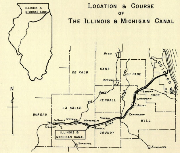
The canal, which opened in April 1848, is a 96-mile hand-dug canal that became historically consequential because it completed an inland, all-water route from the East Coast to the Gulf of Mexico for the first time. The I&M Canal was key to the development of the Midwest and helped fuel westward expansion. It revolutionized Illinois’ transportation system and established Chicago as a gateway for goods and people traveling throughout the continent. It also served as the gateway to the West and ended Chicago’s days as the western frontier.
IDNR has an important connection with the canal by way of the State of Illinois’ Board of Canal Commissioners, the predecessor of today’s IDNR Office of Water Resources. In addition, IDNR oversees the Illinois and Michigan Canal State Trail, 61.5 miles of old towpath from Rockdale to LaSalle, featuring scenic views and the Des Plaines and Illinois rivers.
For more information about the I&M Canal, visit https://dnr.illinois.gov/waterresources/im-canal.html
or https://iandmcanal.org/
To learn about the I&M Canal State Trail, visit https://dnr.illinois.gov/parks/park.imcanal.html
Michael Siola shared
 |
| 1 |
 |
| 2 [I recognize this as Lock #6.] |
 |
| 3 |
It was the first National Heritage Corridor that was created. So it is easy to find plenty of other info on it.
A description of the Canal by the Metropolitan Water Reclamation District of Greater Chicago.
 |
| MWRD posted A home is seen along the banks of the Illinois and Michigan (I&M) Canal in 1899. The I&M Canal provided portage for many vessels from the South Branch of the Chicago River to Peru on the Illinois River, carrying cargo such as grain and lumber, almost 50 years prior to the beginning of construction of the Chicago Sanitary and Ship Canal. The I&M Canal faced competition from the railroads for passenger service and cargo shipping almost immediately after completion, and by the time the Chicago Sanitary and Ship Canal was opened in 1900, its role was reduced further and was finally closed in 1933. |
A picture book by Joseph P. Balynas, The Illinois and Michigan Canal A Photographic Journey, provided some details that I have not seen in most histories of the canal. I will use "JPB" in the references to this book.
I had noticed his pictures on Facebook, and I was glad to see he finally published some of them. The book is a "picture book" with one picture and a caption on each page. I normally avoid picture books because the captions usually contain a lot of redundant information, and they don't explain the subject very well. But this book was quite informative as well as "pretty." It is also small and affordable. Joseph also has a Flickr album of 304 photos. But I could not find one of his pictures that I remember was taken in the Canal Origins Park. I have driven to that park, but I could not figure out how to get to the park without risking life and limb trying to jaywalk across Ashland Avenue.
Lock #1 is in Lockport. In the initial plan, this was to be the first lock because the canal was to be cut at lake level from the South Branch of the Chicago River to here. The original plan was known as the "Deep Cut" plan. But they quickly devised the "Shallow Cut" or "Summit Level" plan. They built a lock and pumping plant at Bridgeport so that the canal started eight feet higher than the river. "A second 'summit level' lock would be constructed at Romeo (todays Romeoville) about 1/2 mile south of 135th Street to bring boats slightly down to Lockport level.
I had noticed his pictures on Facebook, and I was glad to see he finally published some of them. The book is a "picture book" with one picture and a caption on each page. I normally avoid picture books because the captions usually contain a lot of redundant information, and they don't explain the subject very well. But this book was quite informative as well as "pretty." It is also small and affordable. Joseph also has a Flickr album of 304 photos. But I could not find one of his pictures that I remember was taken in the Canal Origins Park. I have driven to that park, but I could not figure out how to get to the park without risking life and limb trying to jaywalk across Ashland Avenue.
 |
| I&M Canal National Heritage Area posted The I&M Canal was the final link needed to create an all-water route across the United States of the 1800s. By connecting the waters of the Illinois River with those of Lake Michigan, the Illinois & Michigan Canal (which is named for these two bodies of water) brought together the Northwest, South, and East (note that at this time Illinois was considered “Northwest”). Travelers from the eastern U. S. could take the Hudson to Albany and then the Erie Canal to Buffalo, where steamboats brought them through the Great Lakes to Chicago. Transferring to canal boats, a 96-mile trip on the I&M Canal brought them to LaSalle/Peru. Here people boarded river steamers bound for St. Louis and New Orleans. |
 |
| I&M Canal National Heritage Area posted You probably didn't realize that these TWO factors (among others) influenced the building of the I&M Canal in the 1800s... 1) The ever-increasing population of the East needed food–especially as it moved from agriculture to industrialization. The "West" (as in, at the time, Illinois) had expansive, stone- and tree-free soil that would be easy to farm. 2) The East (especially New York) wanted to maintain economic dominance over the South by developing a water route to the "West" and driving commodities in their direction as opposed to down the Mississippi River to New Orleans. When the I&M Canal was built and connected Lake Michigan to the Illinois River (which flows into the Mississippi), the inland waterway from the East Coast to Gulf of Mexico benefited the entire nation enabling the easy flow of goods and resources to all regions. But, it also helped sow some seeds of discontent for the bitter Civil War that was to come in the 1860s. Discover more interesting reasons and results by reading the Canal Story on our Substack: https://bit.ly/IMCanalsImportance **** Unfamiliar with Substack? Here are some tips: 1) Click the link above. The landing page may ask you if you would like to subscribe. Please do! Then, you'll receive an email every time we add a new Canal Story. 2) Subscribing is FREE. Just make sure to look for and click the free option. Or, you can choose one of the paid donation options, which will help fund our programming throughout the year. 3) More questions? Reach out. We're happy to help. Roger Michels: In an odd way, the canal put Chicago on the map bringing storehouses (grain elevators) full of corn via the waterway to market... and the commodities market (CBOT) of the Midwest was born! Oh, yes and Saint Louis was still transporting farm produce in sacks and wagons to their transfer point (the Mississippi)... all quickly to be replaced by railroads and the technology storm to come. Richard Bartecki: Can you tell us where the photo was taken? |
 |
| Greg Daniels commented on the above post |
 |
| Dennis DeBruler commented on Greg's comment This is correct; it is an aqueduct that I didn't even know about over the Little Vermillion River. https://maps.app.goo.gl/7TEsmtDJ1xW9xeyEA In addition to the former-IC truss bridge, we can see the Joliet Street Bridge in the distant background. |
Lock #1 is in Lockport. In the initial plan, this was to be the first lock because the canal was to be cut at lake level from the South Branch of the Chicago River to here. The original plan was known as the "Deep Cut" plan. But they quickly devised the "Shallow Cut" or "Summit Level" plan. They built a lock and pumping plant at Bridgeport so that the canal started eight feet higher than the river. "A second 'summit level' lock would be constructed at Romeo (todays Romeoville) about 1/2 mile south of 135th Street to bring boats slightly down to Lockport level.
Both locks were removed in 1871 when the Deep Cut plan was carried out in an effort to flush sewage from the Chicago River into the canal and then downstream to the Illinois River." [JPB, p 16] But the flow through the canal was too slow to flush the Chicago River, that is why the CS&SC was opened in 1900.
Each lock was 110' long and 18' wide. So the boats were 90-100' long and 17' wide. [JPB, p 22]
Each lock was 110' long and 18' wide. So the boats were 90-100' long and 17' wide. [JPB, p 22]
 |
| Lewis University Photo Collection |
 |
| safe_image for The Illinois & Michigan Canal The Illinois & Michigan Canal connected the Illinois River at LaSalle, IL with the Chicago River at Bridgeport, Chicago, IL, creating a waterway between the Mississippi River Basin and the Great Lakes Basin. This canal created a navigable route between the Great Lakes and the Gulf of Mexico, and helped solidify Chicago as an early transportation hub. |
 |
| Illinois and Michigan Canal Photo Tour posted After the Drainage Canal [Chicago Sanitary & Ship Canal] extension was completed in 1907, the canal between Chicago and Joliet was virtually abandoned. With the completion of the Cal-Sag channel in 1922, which bisected the canal near Lemont, the canal was allowed to dry up between Chicago and Summit. Here railroad tracks run along the dry bed, and in the future the Stevenson expressway (originally to be called the I&M Canal expressway) was built over and on the canal bed from Damen to Harlem. Dwayne Weber: Is this looking east toward Chicago from the Summit curve? Illinois and Michigan Canal Photo Tour: Sure looks like it. I thought so too, the photo had no caption though. |
Christie Pasieka posted three images with the comment: "Seems like a good time to post more on the I&M Canal. Illustrations go back to the year 1873 and the different boats and their usage."
 |
| 1 |
 |
| 2 |
 |
| 3 |
 |
| Larry E. Bird posted The I&M Canal boat " City of Pekin is filling with grain from a elevator from the south side of the canal. Not lock 14 because it was on the north bank a large grain elevator in the early canal years . |
 |
| Michael Nieslawski posted LaSalle Montauk Tugboat on Illinois Michigan Canal April 30th 1865. [A commented pointed out that this is steam powered.] |
As I write notes about specific structures in and along the canal such as locks, aqueducts, grain warehouses, boat yard, etc.; I tag them with the "canalIM" label.
(new window)
For my future reference, I'm recording dates on which I took canal photos. This is not complete. This is what I found while I was looking for a photo of a bridge over the canal in Lockport.
20140518 Lock #1
20140614 Canal running through the Lemont Quaries (stuck towboat from Houston, TX), #2
20140627 Seneca, Morris during high water, locks #6+#7
20150808 Locks #14+#15
20150809 La Salle County Historical Museum, North Utica green water, Ottawa canal trail
20170607 Lock #5, Lockport trail
20180917 Morris green water, Johns Manville swing bridge
Aqueduct over Fox River and Feeder Canal in Ottawa, IL
5 videos about the canal, I haven't had the time to watch them.
5 videos about the canal, I haven't had the time to watch them.
No comments:
Post a Comment