 |
| Canal Society of Indiana posted and Indiana Historical Bureau Indiana had plans for at least 5 canals during the 19th Century The Ohio Falls Canal - some dirt moved but lost out to Kentucky The Wabash & Erie Canal - Completed Toledo, OH to Evansville The Central Canal - partially completed in the Indianapolis area The Whitewater Canal - Haggerstown to Lawrenceburg, IN The Erie & Michigan Canal - some works near Rome City See CSI website at Indcanal.org for details and tour guides |
 |
| Jennifer Isabelle Carr posted On this day in 1827, the United States Congress provided a land grant to Indiana to encourage the state to build the Wabash & Erie Canal. The canal would eventually reach Evansville and become the longest canal ever built in North America at 460 miles. This 1939 map from Indiana Historical Society shows the completed and planned canals in the state of Indiana. Bob Strenad plagiarized the image and description |
This is mostly the usual generic comments about canals. But it does say that in 1837 the Indiana legislature pass the mammoth internal improvements act. Starting here, he actually talks about the Central Canal. I remember 1837 because of the Panic of 1837. He does discuss that at 8:42.
 |
| 13:59 video at 5:48 The Indiana Central Canal |
Eight grade curriculum guide
The locks were 90'x15' and the channel depth was 4'
 |
| Screenshot |
Wabash & Erie Canal
On March 2, 1827, Congress provided a land grant to encourage Indiana to build the Wabash & Erie Canal. The original plan was to link the navigable water of the Maumee with the Wabash through the seven mile portage at Fort Wayne. Work began five years later on February 22, 1832, in Fort Wayne. Construction proceeded west as the canal reached Huntington by 1835, Logansport in 1838, and Lafayette in 1841. Work was also performed east toward Ohio, but the canal did not open to Toledo until 1843. A second federal land grant enabled the canal to reach Terre Haute by 1849. At Evansville, 20 miles of the Central Canal had been completed north by 1839. The Wabash & Erie Canal was extended south in the late 1840’s through the abandoned Cross-Cut Canal works to Worthington and then south following the old proposed Central Canal route. The connection with the Evansville segment was completed in 1853, forming the longest canal in the United States. By 1860, portions south of Terre Haute were closed and the process of decline continued northward. In 1876, the canal was auctioned off by the trustees; only 140 miles of the canal are still in use today....The canal was 40 feet wide at the berm, 26 feet wide at the bottom, and 4 feet deep. The berm was 6’ wide. The towpath was 10’ wide and was used to pull the boats with mules and horses at a speed of 3-5 mph. Mules were usually used, as they were stronger animals. The ropes used to pull the boats by the mules were 3” in diameter and 100’-150’ long. [Monteaum]
Canal Society of Indiana posted:
This chart shows locks needed for Wabash Erie Canal to reach from Lake Erie to the Maumee River and the summit in Ft. Wayne. The Wabash & Erie Canal was begun in 1832, constructing west from Ft. Wayne toward Huntington. In 1837 construction then began from Fort Wayne to the Ohio State Line and was completed by 1840. Ohio didn’t complete her portion of the canal from Toledo westward until 1843. The chart below shows that there were 29 locks and 108 miles of canal construction to reach the Ft. Wayne summit. The Maumee was a meandering river through the Black Swamp and was never really a commercial waterway. The dammed St. Joseph River, 6 miles above Fort Wayne, was the water source to feed the W&E Canal at the summit level.TotalMILES LOCKS SEGMENT FT LIFT30 9 Manhattan, OH - Grand Rapids 681 - Slackwater in Maumee river -26 4 Grand Rapids - Independence Dam 324 - Slackwater in Maumee river -9 7 Defiance - Junction OH 5718 6 Junction - Indiana State Line * 2820 3 State Line - Fort Wayne IN * 21-------- -------- --------108 29 Ft. Wayne - Manhattan, OH 206* Portions of Black Swamp137 miles - Maumee River = 179 feet total elevation
 |
| Canal Society of Indiana posted A summit canal is one that has a high level where the canal water flows in two opposite directions. As water only flows downhill due to gravity, a water source must be introduced at the summit level. Sometimes it is necessary to build a reservoir to retain sufficient water but when no water source is available that technique cannot be used. The Wabash & Erie has two summits. The first is the Ft. Wayne Summit. Another summit is located between Terre Haute and Worthington, Indiana on the “Cross-Cut” portion of the Wabash & Erie and is 78 feet high. Both water from this second summit coming into Terre Haute from the south and water from the north flow, into what is called the Nadir Level or lowest level. New members joining our Canal Society receive the full profile map of the Wabash & Erie as partially shown above. See Indcanal.org website Canal Society of Indiana – Wabash & Erie Canal Profile Map S Water from Eel River - Terre Haute --- N Water from Parke County |
 |
 |
| Wabash & Erie Canal Park posted WABASH & ERIE CANAL FACTS AND FAQ'S: Day 4 When visitors see how long the Wabash & Erie Canal was, they sometimes ask where else they can go see it. The unfortunate truth is that we are one of the VERY few spots along the full route where you can clearly see the canal as it once was! The canal brought extensive and rapid change to Indiana, and yet it is a "hidden wonder" today. Here are a few quick examples of how the Wabash & Erie transformed the Hoosier State: But if you're a sleuth and ynullou want to track the route of canal, check out the interactive Google Maps feature that the Canal Society of Indiana has on their website: https://indcanal.org/maps-statistics/wabash-erie-canal/ When you walk our historic trails and visit Canal Park, you get the rare opportunity to witness an engineering marvel that is still magnificent even 150 years after its closure! IMAGE: from indcanal.org STATISTICS: from research of Tom Castaldi, Ronald E. Shaw, and Harry Sinclair Drago Wabash & Erie Canal Park: Ramona Seese Thornburg Our pleasure! The full scope of the canal wasn't known when the project started, so you weren't entirely incorrect! The initial plan was to link the Maumee and Wabash Rivers, using the canal as a sort of "connector" for where steamboats couldn't reach. However, after construction had begun, Indiana took on a massive infrastructure loan and the project grew exponentially in size and cost. The extensions to Terre Haute and later Evansville were fueled as well by Federal land grants that seemed like "free money/land" for Indiana. When Terre Haute was reached and the orders came down to extend all the way to Evansville, nobody was more surprised than Jesse Williams, the chief engineer for the project! With the canal completed, you could ride in a single boat for 7-9 days, pulled by mules, and travel from Evansville to Toledo (or vice versa). Canal Society of Indiana shared |
 |
| Facebook Reel |
Whitewater Canal
"As settlers moved into the old Northwest Territory after 1800, transportation routes became an important priority. Indiana’s brief experience with canal building began with the passage of the Indiana Mammoth Internal Improvement Act of 1836. Whitewater Canal was one of several projects funded by this act. The Whitewater Canal started in Lawrenceburg and originally ended at Cambridge City, on the Old National Road. Hagerstown merchants financed an extension to their town, making the canal 76 miles in length. The state of Ohio also built a 25-mile spur linking Cincinnati to the canal. Along the canal, 56 locks accommodate a fall of nearly 500 feet." [IndianaMuseum] It reached Brookville, IN, in June 1839. [IndianaHistoricalBureau] It was at Connersville in June 1845 and by Oct a boat had reached Cambridge City. [Video] The map below shows that it reached Hagerstown in 1847.Because a lot of water-powered industry had developed along the canal such as the mill that still exists in Metamora, the canal was maintained until the 1950s to supply water for industries in Brookville, IN.

 |
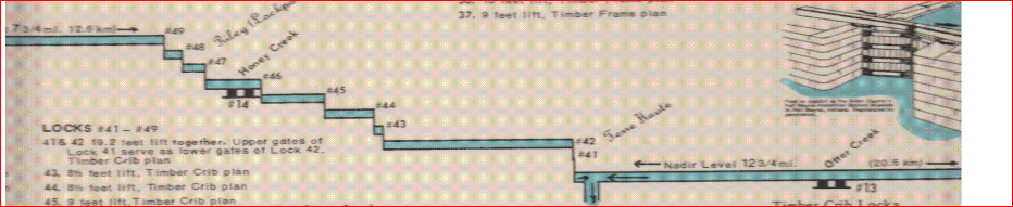
| Canal Society of Indiana posted The second type of aqueduct was the enclosed or covered bridge type. The construction is the same as the open trunk. Then the structure is enclosed with a wooden frame above to protect the timber frame that is exposed to weathering in the open trunk style. There is a total of 20 aqueducts on the Wabash & Erie Canal in Indiana, but only 5 were roofed and enclosed. The longest, 510 feet long, was across the White River near Petersburg. It was roofed. On the Whitewater Canal there were 2 aqueducts. One crossed the Whitewater River just south of Laurel, and the next was at Duck Creek as shown in the photo below [above]. Kirk Patrick Shorter: There is a 3rd on the canal.... very small & easily missed. It is at the area of Goose Creek. |
Doug Arthur posted three images with the comment: "My Mentor Paul Baudendistle put together a map of the Whitewater Canal and called it 'A Key to the Locks'."
 |
| 1 |
 |
| 2 |
 |
| 3 |
He shows lock #24, and then he gives a history of the canal.
 |
| 10:19 video |
Doug Arthur posted a PDF download link with the comment: " I made a PDF of the entire project. It was researched and put together by the foremost authority on the Whitewater Canal Mr. Paul Baudendistle from Metamora Indiana. All the credit goes to him and please don't use any of this without crediting Paul."
A 171 page history, but the maps stop at Brookville.
wow amazing
ReplyDelete