Tuesday, April 30, 2019

CP/Milw Bridge over Rock River at Byron, IL

(1882 Bridge Hunter; 1897 Bridge Hunter; 1905+? Bridge Hunter; no Historic Bridges; Satellite, you can see that the piers for probably the 1897 bridge are still standing.)

Dave Durham posted
CM&St.P, Byron, Illinois, 1899
Laird Barber It was a double track line until the late 1970's when it was single tracked by the MILW Road, and is now owned by the Canadian Pacific.

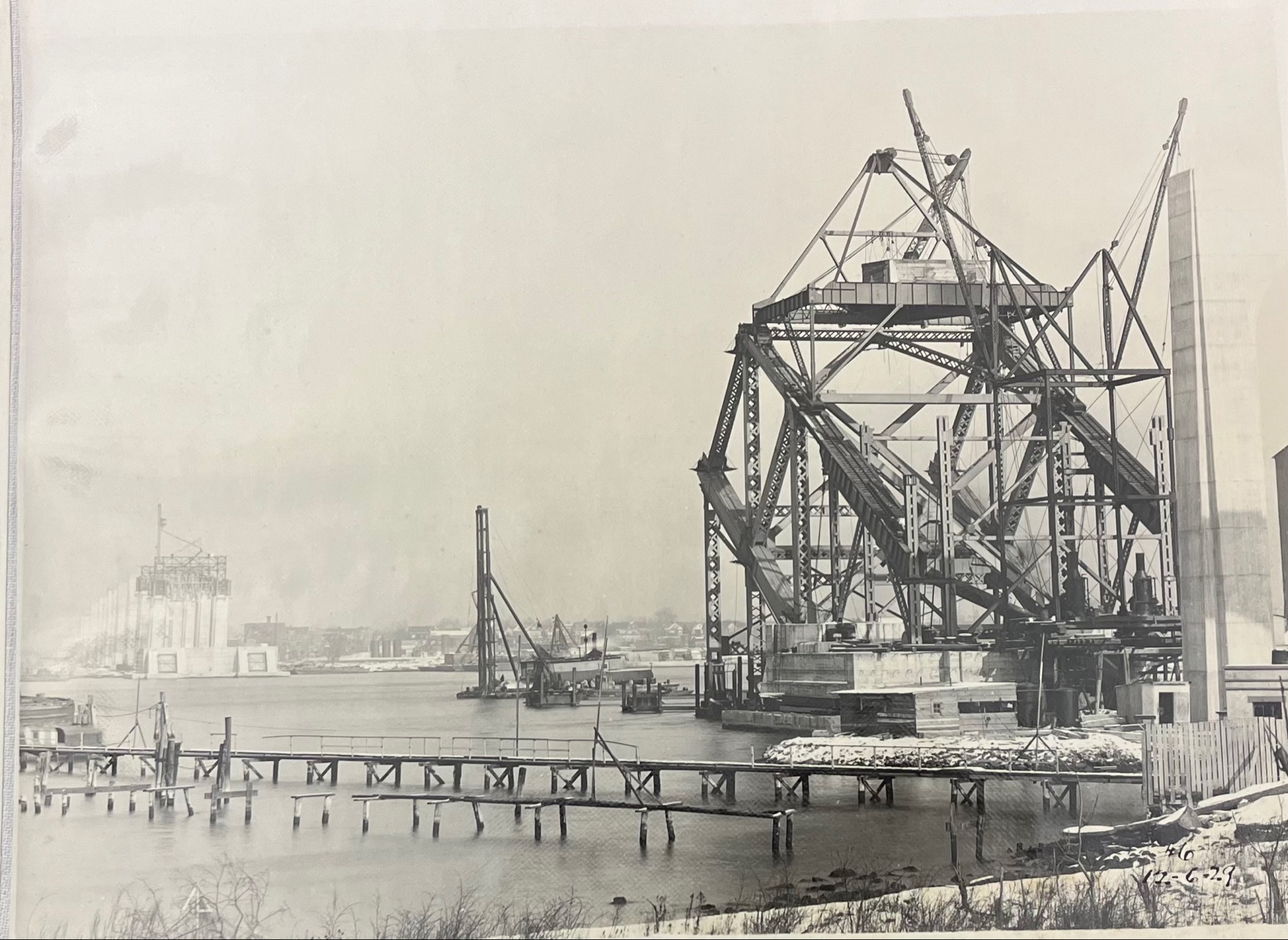
Public Domain via 1897 Bridge Hunter
These twin spans are a puzzle. Since the southern one is pin connected, it is older than the northern one. But the concrete pier on the south is more modern than the cut stone part on the north. However, the northern one is upstream so it gets the brunt of the ice flows. Maybe scouring is what caused the southern part of the piers to require concrete repairs.
Steve Conro via 1905+? Bridge Hunter
Jeff Lewis posted
Canadian Pacific twin truss spans cross the Rock River just east of Byron, Illinois. The twin cooling towers of the Byron Generating Station loom to the south as steam billows into a cloudy August afternoon.
Aerial photography courtesy of Jennelle Smith. August 17, 2020
Flickr1
 

Jeff commented on his post
Flickr2

The only customer for this bridge is going to disappear.
safe_image for Exelon Generation to Retire Illinois’ Byron and Dresden Nuclear Plants in 2021
Despite being among the most efficient and reliable units in the nation’s nuclear fleet, Dresden and Byron face revenue shortfalls in the hundreds of millions of dollars because of declining energy prices and market rules that allow fossil fuel plants to underbid clean resources in the PJM capacity auction, even though there is broad public support for sustaining and expanding clean energy resources to address the climate crisis. The plants’ economic challenges are further exacerbated by a recent FERC ruling that undermines longstanding state clean energy programs and gives an additional competitive advantage to polluting energy sources in the auction. As a result of these market rules, Exelon Generation’s LaSalle and Braidwood nuclear stations in Illinois, each of which house two nuclear units and together employ more than 1,500 skilled workers, are also at high risk for premature closure. 
 
Studies have shown that when nuclear plants close, plants that burn fossil fuels operate much more often, increasing harmful carbon and air pollution, especially in disadvantaged communities. In January 2019, Illinois committed to reducing greenhouse gas emissions consistent with the targets set in the Paris climate agreement. While the state is currently at roughly 85 percent progress towards the 2025 goal, if the four economically challenged nuclear plants (Dresden, Byron, Braidwood and LaSalle) prematurely retire, Illinois will drop to only 20 percent of the way toward the goal. Electric sector emissions in Illinois will increase by 70 percent. 

Monday, April 29, 2019

Pere Marquette Ferry Dock in Port Huron, MI

(Satellite, 20 photos)

There are more photos and location information in PM and GTW Ferries.

Friends of the Pere Marquette Railroad Bridge, Inc. posted

This photo is older than 1931 because that is when the swing bridge was replaced with an Abt trunnion bridge.

Satellite
While trying to figure out if photo's view is looking north or south, I noticed on Google Maps that there still exists a carferry apron. Taking a closer look at the photo, you can see two aprons in the left background.
Upper-left corner of the above photo at photo resolution

Global Earth
I figured that this yard would have been abandoned by the time of the oldest satellite image, 1999, on Google Earth. But to my surprise, the yard was not only still used, there was a ferry docked at the remaining apron. Looking at Historic Aerials, the 1951 image shows both aprons are intact.  The 1964 aerial shows the northern one is no longer used and the apron has been removed. By 1973, they have filled in the shoreline to today's configuration.

These aprons and their tracks is another opportunity to check the accuracy of the USGS topo maps. Below is an excerpt from a map labeled as 1940 at 24,000 scale. It shows the two indents, but not accurately. The northern indent has the profile of 1973, not 1951. Furthermore, there is a track heading to the southern apron, but not to the northern apron.
USGS
Peggy Lindquist, 2016, cropped

Craig Brenton posted four photos with the comment: "Port Huron US to Canada carferry."


seung won lee, 2017

Marcie T, 2017
Peter Michael Photography Studio, 2017

Street View
I'm preserving some current images because a street view indicates they are doing construction in the vicinity. If they do develop the land, I hope they preserve this history.
Street View
Satellite


Sunday, April 28, 2019

1931,2017 Bayonne Bridge over Kill Van Kull at Staten Island, NYC, NY

(Bridge Hunter; Historic Bridges; HAERDave Frieder Photos3D Satellite, 213+ photos)

Significance:
1. Aesthetically striking steel arch span bridge designed by prominent bridge designer and
engineer, Othmar H. Ammann
2. World’s longest steel bridge for nearly half a century
3. First use of manganese steel (for main arch ribs and rivets) in bridge construction
4. First use of falsework for construction of an arch of this span
Photo from HAER NJ,9-BAYO,1-11 from nj1025

BAYONNE BRIDGE, FROM OVER STATEN ISLAND LOOKING NORTH - Bayonne Bridge, Spanning Kill Van Kull between Bayonne & Staten Island, Bayonne, Hudson County, NJ


Nathan Holth on his Historic Bridges page complained about the lack of documentation for the new bridge. I share his frustration. Normally for a new bridge, you can find proposed alternatives, concept illustrations, environmental impact statements, and/or materials for public presentations. The only concept illustration I could find is this little one on their About page. Traffic had to use two lanes instead of four lanes during the six years of construction, but they were able to get rid of the lower roadway under the arch by 2017 to make room for New Panamax ships.

About
The deck on this bridge has been raised 64' to allow super-panmax ships to access container terminals on the other side. They are also having to dredge a deeper channel, 51'-57' depending on the stage of the tide. The 2000' wide Ambrose Channel starts twelve miles out in the ocean. It was built in 1931 with a clearance of 151'. In the mid 20th Century, the Port Authority predicted that the superstructure of ships in the future would top 190'. Pieces of the roadway over the water were removed by lowering them onto barges. The new channel was tested with a new container ship, CMA CGM Theodore Roosevelt, that is 1200'x158'x52.5' and can hold 14,414 containers. The previous maximum capacity was 9,400 containers. That ship stopped at other east coast ports before it docked at NYC. That would reduce its draft to below 51'. In fact, it was just 40.85'. This ship went under the Bayonne Bridge on Sept. 7, 2017. The wheelhouse on this ship was at the same height as the old roadway. "According to Port Authority statistics from a few years ago, seven million vehicles cross the Bayonne every year. About a hundred and three million vehicles use the George Washington." The bridge won't be finished until 2019. [NewYorker, pay count of 4. Some of the article talks about how dangerous the Kill Van Kull strait is to navigate because of tides coming in from both sides and a sharp turn in the shipping channel. The article also discusses Ammann, who was the designer of this and several other major bridges, and the harbor and sea pilots.]
safe_image for The Bayonne Bridge's New and Higher Road Deck

Bridges Now and Then posted
The Bayonne Bridge, linking Staten Island, NY, and Bayonne, NJ, seen c. 1930. (Staten Island Advance)
Dave Frieder: Most of the design for the new road deck was by former Port Authority Chief Engineer, Jim Starace.
Raised from 151 feet to 215 feet. MWH.
EM Payette: This was blown up in War of the Worlds?
Tommy Flett: EM Payette : yes. I lived a block away from the bridge and watched the film it every day.
Christopher White: Interesting bit about the improved bridge, the precast concrete parts were poured in Cape Charles, Virginia, and floated up the Chesapeake Bay, to the C&D Canal, and out to the Delaware Bay, and up to Bayonne.
Thomas Pianetti: Worked on the nj abutment rebuild in 2003 and the raising in 2014. Surveyed on both.
 
Dave Frieder commented on the above post
Engineer of Design, Allston Dana. Great bridge to climb and photograph!

Anthony Noa commented on the above post, cropped
This is the Bayonne Bridge today , with a New roadway deck raised 64 feet higher to accommodate the new bigger Panamax ships.
 
Greg Villani commented on the above post
demoing the old roadway. most definitely my favorite job.

Port of  NY Authority via Historic Bridges, p13

Port of  NY Authority via Historic Bridges, p7
[I included this image because it helps put in perspective the immense scale of the bridge.]

Second Progress Report via Historic Bridges, p13
[Look at the list of the derrick boat.]

Second Progress Report via Historic Bridges, p16, rotated
[This shows the temporary piers or falsework and the temporary support above the second pier so that they can cantilever the remainder of the arch and avoid putting a pier in the navigation channel.]
Second Progress Report via Historic Bridges, p20
[I didn't realize that the navigation channel was so far off-center until I saw this image.]
Dedication via Historic Bridges, p7
[Given the stone encasement of the abutments, this is obviously a concept illustration. Like the towers of his George Washington Bridge, Ammann obviously intended for the steel work to be covered by stonework. But the depression happened before the bridges were completed, so the stone work, which was purely decorative, was skipped. Some people have argued that the raw strength of the towers looks better without a stone facade.]

Bridges Now and Then posted
Building the Bayonne Bridge, spanning the Kill Van Kull, connecting Bayonne, New Jersey, with Staten Island, New York, c. 1930. (LI Salzman Architects)
 
Michael Pawlek commented on BN&T's post
I saw this in a junk shop in Staten Island just yesterday
 
Dave Frieder commented on BN&T's post
ORIGINALLY known as the Kill Van Kull bridge. Engineer of design, Allston Dana. Modeled after the Hell Gate Bridge.

LC-DIG-highsm- 45369
Credit line: Photographs in the Carol M. Highsmith Archive, Library of Congress, Prints and Photographs Division.
Carol M. Highsmith's photographs are in the public domain.

A street view catches the original steel girder approach spans and the new precast segmented partial approach spans. Before they can finish the new piers and approach spans, they need to remove the old roadway. After the second part of the new piers are built, they can remove the yellow pipes.
Street View

3D Satellite
[I saved an image because this catches the phase where the new deck is full width, but the approaches can't be finished because the old deck still exists.]
Since it is supposed to be finished this year (2019), I really don't need a concept illustration because the web cam shows what it is supposed to look like. Evidently, it is still not done because their web page indicates the pedestrian walkway is closed, and it is still displaying Nov 4, 2013, truck restrictions due to the construction.
Web Cam, accessed Apr 28, 2019

(new window)  Among other things, this video animates how a travelling gantry installs the precast segments for the new approach spans.


(new window)


This container terminal doesn't care about the height of the Bayonne Bridge. But these are the terminals I found that do care: New York Container Terminal, APM Terminals (can handle ships in both Newark Bay and Elizabeth Channel), and Port Elizabeth Terminal Corporation.

While looking for container terminals, I found these two RoRos (Roll-On, Roll-Off) in dock. Since I've never seen one with their ramp out, I wanted to capture this image.
Toyota Logistics Services

Update:
RoadsBridges-general
[The lanes are widened from 10' to 12' and a median barrier plus two 5' shoulders are added. By keeping the construction within the current footprint, they reduced the environment planning phase from four years to eight months.]
And they did not displace residential homes that were within 20' of the work site. [RoadsBridges-2018]

RoadsBridges-general
With additional weight on the structure and increased wind loads, the team added more than 4,000 tons of steel plates to strengthen the arch....More than 100,000 rivets were replaced with high-strength bolts as part of the strengthening process.

RoadsBridges-early
The $1.6B project finished around Jun 30, 2017, which was 6 months ahead of schedule. It raised the clearance from 151' to 215'.

safe_image for Massive container ship - bigger than 4 football fields - sets record under Bayonne BridgeThe CMA CGM Brazil passes under the Bayonne Bridge in Bayonne on Saturday, Sept. 12, 2020.Dustin Niles | For NJ Advance Media
"The 1,200-foot-long CMA CGM Brazil, the largest container ship [at 15,072 TEUs] ever to call on the bi-state port, or any other port on the U.S. East Coast, for that matter....That $5.3 billion investment includes a $1.7 billion raising of the Bayonne Bridge roadway [to 215'], a $2.1 billion deepening of harbor channels [to 50'], and a $600 million ship-to-rail container transport system."
[The article has a couple of more photos of the ship.]

And now they are up to 16,022 TEUs.
The largest container ship to ever visit the East Coast just arrived at the Port of New York and New Jersey: Meet the Marco Polo (source)
[The Chicago Tribune also had a variant of this news. It is not common for shipping news to make the business section of the CT.]

Bayonne Office of Emergency Management posted
Bayonne resident Corey Tierney caught this amazing shot of the Bayonne Bridge as the storm rolled through tonight.
Thank you Corey for sharing! 


Saturday, April 27, 2019

1935 Mississippi Lock and Dam #4 at Wings over Alma, WI

(John A. Weeks IIISatellite)

USACE
The dam consists of a concrete structure 1,357 feet long with six roller gates and 22 Tainter gates. The movable
dam has six roller gates (20 feet high by 60 feet long), 18 non-submersible Tainter gates (15 feet high by 35 feet
long), and four submersible Tainter gates (15 feet high by 35 feet long). Completing the dam system is an earthen
embankment approximately 5,500 feet long, located between the movable dam and high ground on the Minnesota
side of the river. The dam foundation consists of piles in sand and gravel.

The lock was put in operation in May 1935. At the time it was built, the dam's combination of roller and Tainter
gates was believed to have been the first of its type to be constructed. Cold weather created several problems
during construction of the complex. Approximately 120 timber pilings split and had to be pulled and replaced;
engineers speculated that sap freezing in the green pilings may have caused the splitting. Ten major injuries, 296
minor injuries, and three deaths were reported during the construction of the dam.
  

The pool created by Lock and Dam 4 is the longest in river miles (44.1 miles) with the largest water area of all the
Mississippi River pools in the St. Paul District. It encompasses Lake Pepin, which was formed in geologic time by
sediment deposited in the Mississippi River at the mouth of Wisconsin’s Chippewa River. The lake is 22 miles long
and up to 2.5 miles wide. It is the only natural lake in the Mississippi River’s main channel.
  

Faith Camp shared
Sam Schropp The picture above isn't a current [Spring, 2019] picture. The dams are wide open from Lock 2 to Mel Price at Alton.
I copied a satellite image to show the width of the historic channel cut by the melting ice-age glacier runoff.
Satellite
I assume the four Tainter gates next to the roller gates are the submersible gates because I presume they are the first ones they would open and they would want to keep the normal flow in the middle of the river to reduce erosion. Note that it appears two of them are open in this image.
Satellite

John Weeks III

Marilyn Schack Hulse posted
Alma, Wisconsin, Monday, April 13, 2020, with Lock & Dam 4 in the background.

Dennis DeBruler commented on Marilyn's post
Thanks for labeling the dam. I like that as well as the train. It looks like all of the gates are all the way up. So the river is currently running rather high. It is still well below the flood stages.

USACE posted six photos with the comment: "THEN AND NOW: On this date in 1932, the St. Paul District awards a contract to the Ouilmette Construction Company for the construction of a lock at Lock and Dam 4 in Alma, Wisconsin. More: http://ow.ly/oPex50LkvJ0"
Steven Bruni shared
1

2

3

4

5

6