Showing posts with label confection. Show all posts

Tuesday, December 27, 2022

Tootsie Roll repurposed an aircraft engine plant in Chicago, IL, after Tucker Auto used it

(Satellite)

An alternative title could be (Tootsie Roll+Ford City Mall)/Ford/Tucker/Dodge Plant in Chicago, IL.

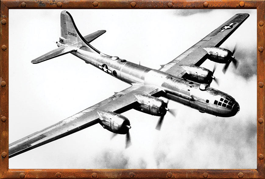
15:27 video @ 0:41
The Write R-3350 radial 18-cylinder, 2,200hp engine powered the B-29 Superfortress Bomber.
From 1942-44, Dodge built a plant that was designed to build 1,600 engines a month. 

@ 1:13
The engine consisted of two 9-cylinder banks.
30,000 people worked here during its peak production. [14:39]

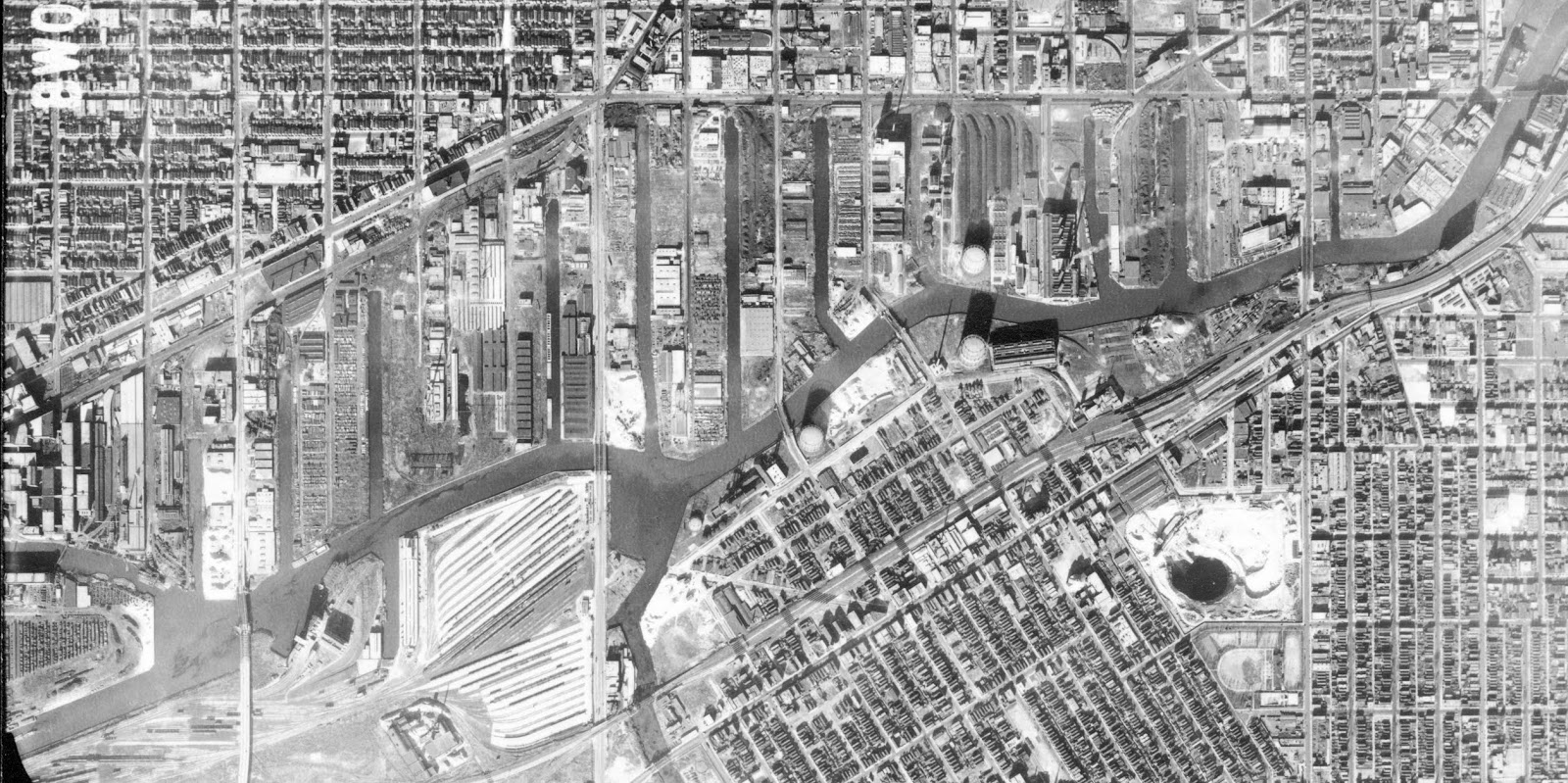
MattStoneCars via FRRaP
[This building was the office building that fronted Cicero Avenue. Most of that land is now a parking lot.]
Buildings were built on a 500 acre "green field" that enclosed 6 million square feet or almost 140 acres. "It was the world's largest building at the time." At the end of WWII, production stopped and the machine equipment was sold off as military surplus. Preston Tucker then leased the facilities to design and produce his 1948 "Torpedo."  But after just 52 cars were built, the plant was closed in 1949.
[I've seen the claim of the "world's largest" in several sources. But I don't know if they mean the big building or all of the buildings. 
This article claims that the B29 was built here. That is wrong. It was the engine that was built here. The B-29s were evidently built in Boing's Kansas City plant. 4000 airplanes were built. Five engines were built for every airplane so that there would be spares. 5*4000*18=360,000 cylinders.]

Dan Nocchi posted five photos with the comment:
In order to build his dream car, Tucker needed a place to begin working. An old Dodge plant in Chicago caught his eye. He leased the plant and rapidly began building the Tucker ’48 prototype. The plant itself covered 475 acres, but the main building covered 93 acres. 
Too bad the big three and the feds shut him down!
Thomas Conforti: If the big three hadn't rigged things against him out of fear of the superiority of the Tucker over their cars. He probably would have been the biggest. All the lies about him that still exist today are a joke.
1

2

3

4

5
 
Eliseo Carrillo posted
The assembly line for Tucker 48 automobile engines at the Chicago plant in 1948.
Steven Cutler: Tucker bought Franklin Motors for their air cooled engines made for Bell Helicopters. They switched all production for the 52 cars they produced ignoring the government contracts they had to produce helicopters which could have been a cash cow for the cash strapped company.
Ryan Tuttle: Tucker bought the Franklin engine company which was going into receivership. The had an air cooled vertical flat 6.
Tucker modified the flat six to horizontal added water jackets with intake runs and a down draft carburetor. The Franklin motor did well in testing and propelled the 48 Tucker to over 120mph.

After Tucker, Ford used the plant to make a different airplane engine.
David M Laz posted
A view of the biggest industrial plant in the world, the Dodge Chicago Plant at 75th and Pulaski Road on Sept. 9, 1945. By 1950, the Ford Motor company would be making 28 cylinder Pratt and Whitney Wasp Major engines for use in Air Force planes. — Chicago Tribune historical photo

1953 Englewood Quad @ 24,000

In June 1942, the first building erected was the tool shop (the red rectangle in the northwest corner of the campus). "Over a million-and-half tools, jigs and fixtures were needed."  And then the office buildings (orange) were built so the initial staff in Detroit could move to the location. On the opposite side of the campus, a die shop and forge division was built (yellow). An aluminum foundry was built to make the cylinder heads (dark blue) and a magnesium foundry was built to make the required magnesium castings (light blue). The big building (green) was for machining, assembly and testing. The parking lot (purple) could hold 13,000 cars. [@ 1:42]
1953 Englewood Quad @ 24,000 plus Paint

This is just the forging part of the complex and this part did not become Ford City.
James Stein posted
Ford City 1960, photo scanned from my dad's collection.
Jim Smith: My grandfather worked for Ford aircraft engine until they closed the plant in '59.

Some of the forge buildings are still standing, but the smokestack has been truncated.
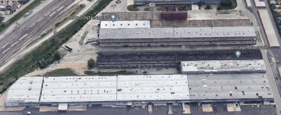
3D Satellite

Three photos posted by Gail Bob McCabe.
1

2

3

So Ford vacated the buildings in 1959. [Jim Smith's comment on James Stein's post above.] Now I became confused because some  Facebook comments say the building became Ford City Mall and other comments say it became Tootsie Roll. By looking at some topo maps, I concluded that both comments are right. The southern part of the big building was torn down to make way for the mall. Tootsie Roll moved into the northern part of the building in 1967 [The date is from a Thomas F Tedesco's comment on a post]. 
1972 Englewood Quad @ 24,000

I came across the following two posts about Tootsie Roll in two days, and that is what motivated me to dig into the history of this building.
Thomas Cook posted
Driving past Tootsie Roll today and I always wonder why the building was built like that and what those structures are/were for?
[I presume the concrete structures above the roof were part of the test stands.
More than 13,000 parts went into an engine. Then an engine ran on one of the 44 test stands driving a generator for four house at various speeds. (Testing generated about $25,000 of electricity each month.) Then an engine was taken apart so that all of the parts could be inspected! Then the engine was reassembled and had a final test. [11:52]]

Thomas Cook was driving down 72nd Street.
Street View

Historic Chicago posted
Inside the Tootsie Roll Factory in Chicago. (1960s)
[Many comments referenced a I Love Lucy show and some comments mentioned the beehive hairdo.]
Heather Iffland: My friend and former coworker from another job is the current SQF Practitioner at Tootsie Roll. It used to be an airplane factory during WW2. It’s over a million square feet. He says they have a golf cart to get around. An SQF audit at my work takes a day and a half for 2 buildings and about 150,000 sq feet of building. Their audit takes 5 days.
[I Googled SQF Practitioner. There were a lot of results about SQF training and certification. I finally found "Safe Quality Food (SQF)." The code is up to Edition 9.]
Colleen Blackburn shared

When I looked at the former magnesium foundry building, I thought it had been replaced because it looks rather modern. But when I watched the video I realized that the architect did build some rather modern looking buildings. So now I believe that this is one of the original buildings. This "little" building looks rather large.
Street View


Sunday, August 14, 2022

Pope's Sugar Beet Factory in Riverdale, IL

(Satellite)

I knew Chicagoland factories used a lot of sugar because it was the candy capital of the world. But I did not know that Chicagoland produced it.
Michael Brandt posted
A really neat picture of Popes Sugarbeet factory at the Calumet River and Indiana Ave. Notice the old Indiana Ave swing-bridge that was replaced in the 70s, I have pictures of that project also.
Michael Brandt posted
It's Popes Sugar Beet Works on the shore of the Calumet River just West of Indiana Ave.

Raymond Boerema commented on Michael's post
View from Indiana Avenue

eBay
Riverdale Illinois~Chas Pope Beet Sugar Works Factory~Smokestacks~c1910
 
David Ruklic posted
Here is a picture of the Pope's Sugar Beet Factory taken from a hot air balloon over the neighborhood down Indiana Ave. along the Calumet River before it was dredged.
Daniel Cook: I know Cal-Sag was built 1911-22 and widened 1959-65, but did Calumet River get dredged at the same time? Was it part of the same project in phases, or did one necessitate the other having to follow?
This should have been my first stop!

1901 Calumet Quad @ 62,500

You know something is really old when it is gone by the time these old aerials were taken.
1939 Aerial Photo from ILHAP


Tuesday, March 29, 2022

1920-1993 Leaf Brand Candy Company

(3D Satellite)

Leslie Manson posted
My aunt through marriage worked at Leaf Brand Candy, 1155 North Cicero, in the 1960's. My brothers and I loved when she would bring candy like spearmint leaves, orange slices and whoppers over to us. Sadly like most of the candy factories here in Chicago it moved out of state.
[There are a lot of comments about some of the other candy companies, working for a candy company and getting treats from candy companies....Leaf Brands was originally founded by Sol S. Leaf in Chicago, Illinois. Mr. Leaf started various candy companies beginning in the 1920s, and they were merged into Leaf Brands in 1947.]
Jamiana Antonia posted
Ray Simpson: Loved the Orange candy. Word is that Ferrara Pan has purchased a major brand and is bringing it to Forest Park. Gummy Bears - perhaps
Aaron Grace: Ray Simpson not Gummy Bears; Jelly Belly jellybeans!
Toby Faber: All their brands now are owned by Hershey's.
Dennis DeBruler: You can access more information about Leaf Candy, including the link to Leslie's post and the comments on that post, on the page from which Jamiana copied the photo: https://industrialscenery.blogspot.com/.../1920-1993-leaf...

Carey Winteergreen commented on Jamiana's post
Wrong photo…that’s the Brach Candy factory…which stood on the corner of Kilpatrick and Kinzie…nowhere near 1155 N Cicero…notice the terra cotta medallion above the fourth floor…

LeafBrands
"Originally, Leaf Brands® was started in the 1920’s by the members of the Leaf family. Leaf was responsible for producing such candy classics as Whoppers®, Milk Duds®, Jolly Rancher® and Rain Blo Bubblegum®, just to name a few classic Leaf brands....By the 1990s, Leaf had become one of the world’s top ten confectionery companies; it was especially strong in non-chocolate products such as pastilles and chewing gum and by 1993, Leaf was the fourth largest candy producer in North America before finally being purchased by Hershey’s Candy."
They also produced Payday and Heath Bar. [LstopTours]

Street View

The building was purchased in 1996 by Erickson, "which manufactures personal-care products for clients such as Helene Curtis, a unit of Unilever Home and Personal Care Inc., Gillette Co., and Colgate-Palmolive Co....The company is riding a wave of growth, fueled in part by a trend of major manufacturers, such as Sara Lee Corp. and Bristol-Myers Squibb Co., to maintain their marketing business and contract out the manufacturing of their products." That company created over 200 jobs for the neighborhoood. [ChicagoTribune]

Hershey bought the "Leaf North American confectionery operations" in 1996. [en-academic] But the previous owner must have closed the Chicago factory in 1993 because the above 1997 Tribune article says the factory quit making candy four years earlier.

3D Satellite

MadeInChicagoMuseum

Saturday, May 23, 2020

Americans consume a lot of sugar (Indiana Sugars)

I'm noticing that the distribution of sugar is one of the few industries that still use carload rail service.

Street View of United Sugars
BNSF (CB&Q+Santa Fe) is loosing the Sweetner Supply Corporation business in Brookfield, IL. But it is gaining the "largest single sugar transfer facility in the U.S." in Montgomery, IL. (more below)

Jeff Wojciechowski posted two photos with the comment:
Back in 2016 the BNSF business train visited Montgomery, IL for the grand opening of the nations largest free-standing sugar storage dome. More information about the dome here:
https://www.crystalsugar.com/sugar-processing/factories/montgomery-il/
[The linked article has a time-lapse video of the construction. But the dome just pops into the video at -1:10. I realize that the time scale is quite compressed. But I can't believe it was built in just one frame.]
1

2
Someone must have figured out how to build big domes. While looking along the former Rock Island Pullman Branch I noticed that St. Marys Cement has a big one also. But it is barge to truck.
3D Satellite


Domino Sugar is one of the few remaining industries that BNSF (CB&Q) serves along the South Branch + Chicago Ship & Sanitary Canal. As documented in the Domino Sugar notes and 1860s Industrial Park, there used to be a lot of industry along the waterway.

Recently, I spotted another sugar transload facility. I thought I saw it along the former Rock Island Pullman Branch while researching the location of a Sherwin-Williams Plant, but now I can't find it. Bummer.

While searching for that plant, I did find Indiana Sugars.
Satellite

Dennis DeBruler posted four images with the comment:
While studying the rail service to Indiana Sugars (blue rectangle), I noticed some things. First of all, the green line from the left to the right is appropriate because that is an abandoned IHB branch. But I don't understand what the second green line represents. Also, the red line shows where NS has abandoned another section of the Wabash route. The yellow line shows a connection between the remaining Wabash remnant and CSX/MC that allowed NS to abandon its track. This change is significant because that probably means NS conceded Indiana Sugars carload traffic to CSX. And judging from a satellite image, that carload traffic is significant.
The NS abandonment is recent because the tracks are still in all of the crossings. On Massachusetts Street we see that a spur was abandoned a long time ago and the "mainilne" is now gone. Not only has the track for the spur been removed, the crossing warning had been moved closer to the mainline. One crossing warning was removed, but one is still standing. The gate has been removed, but there is no Exempt sign on it. So what is are school busses and oil tanker trucks supposed to do at this crossing? An Exempt sign can't be that expensive. It really bothers me when a Class I railroad can't properly abandoned a track. I checked the Broadway crossing. It is even worse because it still has both poles without gates, but without Exempt signs. Is Gary stuck with the expense of removing the tracks from nine roads?
The current field of trees between Massachusetts and Virginia Streets used to be industries.

1
https://www.google.com/maps/d/viewer?mid=1Q91IBeZLh916Q5auDaQ9-x25vh0&ll=41.59746402882454%2C-87.34525363264424&z=14

2
https://www.google.com/maps/@41.5951449,-87.3357666,3a,75y,238.85h,77.21t/data=!3m6!1e1!3m4!1saze9EarDMKZ3FrODStw6jw!2e0!7i16384!8i8192

3
https://www.google.com/maps/@41.5950189,-87.3357654,3a,28.5y,321.28h,90.98t/data=!3m6!1e1!3m4!1s_s-XnMFpm9QIgw5uP1p3TQ!2e0!7i16384!8i8192

4
1959 Gary Quadrangle @ 1:24,000

The owner of Indiana Sugars, Maurice Yonover had to fight the ICC to quit accepting N&W's lies about rail service and deny their request to abandon their service to Indiana Sugars. [gary-railroad-blog, shared]
George M Stupar posted
September 8th 2014, Gary IN, The Bakery job power waits on the ex Wabash Railroad 4th District mainline. Indiana Sugars is at left.
George M Stupa I was up there a couple of weeks ago, on May 11th. NS 4703, the GP33 ECO with the green stripe, was working the Indiana Sugars job. Used up a lot of digital megapixels on that motor. Shot about thirty photos, but I'm not sure if they qualify for this group, like in being historical. Otherwise I'd post a few because they came out really well, with the green stripe loco and all.
Dennis DeBruler I think railfanning the switching of industries is historical because it is an example of how all industries looked up through the 1910s. But some stuff, e.g. flying switching and poling, won't have contemporary examples.

George M Stupar posted
May 11th 2020, Gary IN, A view east of Indiana Sugars north siding from Virginia street.
Korry Shepard Any pics of the south side where they installed the new track?
George M Stupar Korry Shepard Stay tuned Korry. Have some older pics of the south side track from the early 80s.

George M Stupar posted
May 11th 2020, Gary IN, The Bakery Job is ready to head back west on the former Wabash Railroad 4th District mainline, after completing its work at Indiana Sugars.

George M Stupar posted
December 1984, Gary IN, Former Wabash Railroad 4th District mainline, Corn syrup tank cars are being switched on the Indiana Sugars long south siding. A covered hopper for granular sugar is on the main. The engine is out of view on the main near the Indiana Harbor Belt overhead.
Mark Egebrecht Was THE IHB still there at this time?

George M Stupar posted
View from the Indiana Harbor Belt highline of the Indiana Sugars south siding, Gary IN 1984, looking north.

If Indiana Sugars in Lemont is not served by rail, certainly Sweet Specialty Solutions is. Their location in Burr Ridge is not rail served.
Satellite

And some plants use so much sugar they skip the transloading to trucks: e.g. Ferrara Pan Candy and Bloomer Chocolate. But some have switched to trucks: e.g. Worlds Finest Chocolate. Chicagoland still has plants that make corn syrup, and they are rail served. (I listed some in Pope Glucose Factory.)


Sunday, December 8, 2019

BNSF/(CIRY/BN/CB&Q + SantaFe/IN) Remaining Industries (Domino Sugar)

CB&Q used to have a lot of industry along the north side of  the South Branch because of an industrial park that it built when it built its Aurora to Chicago mainline in 1862. The Central Illinois Railroad (CIRY) handled those industries between 2000 and 2010. The Santa Fe also served business along the north side of the South Branch using its Illinois Northern Railroad.

There was a comment on the following post saying that, in addition to Domino Sugar, there is a scrapyard by Paulina Street and a new warehouse across the street that is rail served. But those comments must have been deleted by the time I got around to writing these notes because now I can't find them to quote them.

Bryan Littrell posted five photos with the comment: "Domino Sugar in Chicago."
1

2

3

4

5

Dennis DeBruler commented on Bryan's post
I count 13 covered hoppers on the property. I put a red rectangle at what looks like their car mover at the end of a storage spur.
https://www.google.com/.../data=!3m1!1e3!4m5!3m4...
Bryan Littrell Dennis DeBruler most of what they do is transload work and packaging, which is one reason for all the volume.
[Note the car mover is in operation in image 4 above.]

Covered hoppers are not only a much less labor intensive way of handling bulk products, they have to be more sanitary. But they were not developed by Southern Railroad for hauling grain until the 1960s.
Bob Chaparro posted
Unloading Bulk Sugar
Courtesy of Doug Harding, a photo of bulk sugar unloading. Note that this Missouri Pacific boxcar is assigned to sugar service.
I sure hope the giant ants from “Them” didn’t take notice of this.
Bob Chaparro
Hemet, CA
Vernon Davidson: Hough loader? They all leaked hydraulic fluid and engine oil wherever they worked.
I operated an old Hough loader, hydraulic steering and the turning wheels never could keep up with you turning the steering wheel, a crazy thing to steer.
[I thought skid-steers were a much more recent development.]
Rich Cizik Jr.: Looks to be a little Hough model HA doing the unloading.
Larry Hennis: Mixed with tire rubber and diesel fuel! Yum!
Robert Holmén: "Anti-caking ingredient" on the package.
Bob Currie: I hauled a lot of it. It was unrefined sugar, not for human consumption until further refined.

I saved this 3D satellite image because it looks like maybe they receive sugar via barges as well.
Google Maps blew up and after reloading won't give me a 3D image!
The image I now get does show a couple of barges docked at the facility.
Satellite
The new image also shows a different layout of covered hoppers on the property.
Satellite

This photo had me check out the current status of Paulina Street. It is still used 
Edward Kwiatkowski posted
We are in the city of Chicago Illinois on a chilly and overcast morning back in November of 1983.
The Burlington Northern Railroad switching local, is viewed picking up freight cars on South Paulina Avenue in Chicago's Pilsen neighborhood.
Nathan Mackey: Back when the Lumber Street job made the complete loop to Western Ave. yard.

Dennis DeBruler commented on Edward's post
Wow, that spur is still in use. It appears that Sims Metals ships out scrap metal using gondola cars.
Franklin Campbell: Dennis DeBruler Indeed it is, it seems to go through bouts of disuse from time to time when Cozzi/Sims relies more heavily on barges
BNSF reconfigured this spur a few years ago, permanently severing the still intact team track that served Battaglia just east of there. The curve leading into the scrapyard is wider now, and the tracks are now closer to the west side of Paulina than they were. They were pretty much in the center of the street before. 
I have photos of BNSF on the spur in 2018. The only photos I can find of the CIRY (taken by me at least) all face east near the switch. It was tough to get that shot in the street in the morning with security, heavy truck traffic, and the sun rising in the east. 
They apparently had some small centercab back there up until the very early 2000s or late 90s. Whenever loads are picked up, the BNSF and CIRY would never go very far down the spur. A front end loader would shove the cars out into the street. I don't recall if it had a coupler installed like the one at Morton Salt.
You can get a great view of them loading the gons from the riverwalk park on ashland and the opposite side of the canal.
Franklin Campbell: Dennis DeBruler forgot to mention you can get a great view of them loading the gons from the riverwalk park on ashland and the opposite side of the canal.

Dennis DeBruler commented on Fanklin's 
While checking out that view, I see they do actively load barges here. And I counted seven gondolas down by the canal. I would have guessed rail-to-barge transloading. But you indicate they ship by rail and barge.
Dennis DeBruler
 yes i believe everything comes in via truck and goes out via rail and barge. I think they rely more heavily on the rail in the winter. I remember them sending like 25 loaded railcars out one time back in the CIRY days. The CIRY borrowed the BNSF yard power from Western avenue to pull these cars up the embankment. The BNSF power stalled and they used the CIRY switcher to assist from the rear.

Three photos provided as comments by Franklin Campbell on Ed's post.
1

2

3

There used to be a lot of rail served industry in 1929 along the waterway.
1929 Englewood Quadrangle @ 1:24,000
There was even more in 1953.
1953 Englewood Quadrangle @ 1:24,000
It takes two historic aerials to cover this area. From West to East.
08060 from ILHAP

08057 from ILHAP

Illinois Northern handled all of the industries west of Western Avenue and a few that were east of it. CB&Q had a branch that paralleled east of NYC/Chicago Junction from its mainline south to its tracks along Blue Island, south of Cermak Road, and on to Lumber Street, which was an industrial park they built with the South Branch Dock Company in the 1860s.
1953 Chicago Quadrangle @ 1:24,000
The most recent topo map available shows a lot fewer industries, but the IN tracks still went east of Western Avenue.
1997 Chicago Quadrangle @ 1:24,000

Since I started writing this blog in May 2014, BNSF abandoned the Illinois Northern tracks west of Western Avenue and the IN bridge over Western Avenue. They had already connected the IN tracks east of Western Avenue to its CB&Q tracks. They have also abandoned their tracks east of Ashland. The two routes crossing Laffin Street are still used.
Satellite


I used Global Earth to determine when the overpass was abandoned. I think it was between the April 2013 image and the April 2015 image. I saved several of the previous images because they show that the YMCA was built before the IN was abandoned and because almost everyone of them caught at least one train. To catch a train on a satellite image that consistently means that either there were a lot of trains or they were parked on the tracks or both. Also, it is interesting to see how the vegetation in the southwest quadrant changed over the years. I include images around 2018 because I took photos in the area on Aug 12, 2018.

200103

200202

200203

200212

200309

200407

200504

200506

200509

200512

200708

200710

200805

200910

201006

201008

201111

201203

201304

201504

201803

201810

201907

Feb 8, 2022:
Dril Taliaferro posted
Near Blue Island and Wood in Pilsen
Andre Kristopans: There is still a large scrap yard on Wolcott south of Blue Island. Used to be Sims, now? Likely last active customer.

Dennis DeBruler commented on Andre's comment
There are still covered hoppers showing up on the satellite image at Domino Sugar.
I'm trying to figure out if they are loading or unloading that barge.
Andre Kristopans: Dennis DeBruler Domino is last customer on old IN. Sims last customer on old Lumber District.
Franklin Campbell: Andre Kristopans exactly. The Domino lead became part of the "Lumber District" after the BNSF merger when 26th st. Crossing was pulled up.
Domino is the busiest customer at, least in terms of consistency. They usually have a little trackmobile tooling around back there. Sims/Metal Management seems to rely heavily on barge traffic during the warm months, with rail traffic picking up in the winter months.
They go long periods without using rail, but do seem to use it more after BNSF realigned their spur in the middle of Paulina and renewed the trackage and runaround leading to it a few years ago. Sims had some kind of small switcher back there into the early 00s. They will now usually shove the gondolas in and out of the scrapyard with a bigv front end loader. I don't think it has a coupler like the one that worked at Morton Salt.
The cold storage warehouse that is also on the IN Domino lead still maintains their switch and spur, but I only saw them get cars a few times during the CIRY days. They rly heavily on 40 foot reefer containers these days and likely just keep their spur to keep the drayage rates in line.
On the subject of the old INx: here is a rare shot of ATSF working east of the Western Avenue alignment just months before the BNSF merger. I have only seen one other photo of ATSF working here in the early 90s. It is somewhere on rrpicturearchives. View is looking east on 26th street.
https://flic.kr/p/93GNrZ

Dennis DeBruler commented on Andre's comment
Since BNSF abandoned the Illinois Northern route, the IN remnant is now connected to the former CB&Q tracks. So wouldn't Domino be served by the local that Dril caught running? But maybe not this trip since the first car is obviously not a covered hopper.
https://www.google.com/.../@41.8444504,-87.../data=!3m1!1e3
Andre Kristopans: Dennis DeBruler A switch job out of Western Ave Yard covers what work there is in this area.

Franklin Campbell commented on Dennis' comment on Andre's comment
Yes it has been this way since the late 90s. Same job serves both. In the CIRY days when the crew was based out of the old wye at Cermak/Sangamon/Peoria, the crew would switch all the customers along Cermak and Blue Island, park the train just east of your screenshot on the hill and then run down to Domino engine light.
Now the job will typically switch Domino first then run down toward Metal Management.
I haven't been able to discern exactly how this junction used to be laid out, but there was a connection to the BN somewhere in the vicinity as the IN had a small yard along Blue Island avenue where the school bus depot was. Looking at old aerial photos, it was atleast around until the late 70s early 80s. I don't know if that connection was still in place by the mid 90s. If it was i imagine it was somehow unsuitable for switching the Domino lead from the BN side.

Dennis DeBruler commented on Dril's post
I took a photo of the abandoned IN overpass because I was struck by how modern it looked. I wonder how many years of service this overpass saw between construction and abandonment. And if that is the least amount in Chicago. In other words, is this the youngest abandoned overpass in Chicago?
Andre Kristopans: Built on 1980s? Replaced a very old, narrow underpass.
Franklin Campbell
From what I could gather looking at historic aerials, it seems like ATSF/INx heavily reconfigured the tracks in the 1960s when the IH plant was razed. That seems to be when much of the remaining track was laid/re-laid. The Domino building itself seems to have been part of the IH works at some point. It existed well beforehand as did its tracks right along the river, But they were accessed in a less roundabout way that no longer exists from the INx roundhouse and adjacent yard. The present day tracks and runaround leading to Domino did not exist as there were buildings and a canal where it currently sits. This overpass swung southeast over Western avenue and met the large loop that went around the works. A good ways south of the current overpasses. It seems like ATSF was trying to drum up carload business in the Chicago area around this time as this was around the same time they built and were promoting the Argonne Branch in Bolingbrook as well.
According to Loopnet Frozen Assets, the third building to maintain a spur on this trackage was built in 1968. 2635 s. Western.
2555 S. Leavitt, a building with a disconnected spur that went inside of it was built in 1962
2550 S. Leavitt also has/had a spur and was built in 1967
Domino Sugar seems to have been built directly over a smaller IH building that also had rail access in 1954. The old building still existed in 1952 on historic aerials