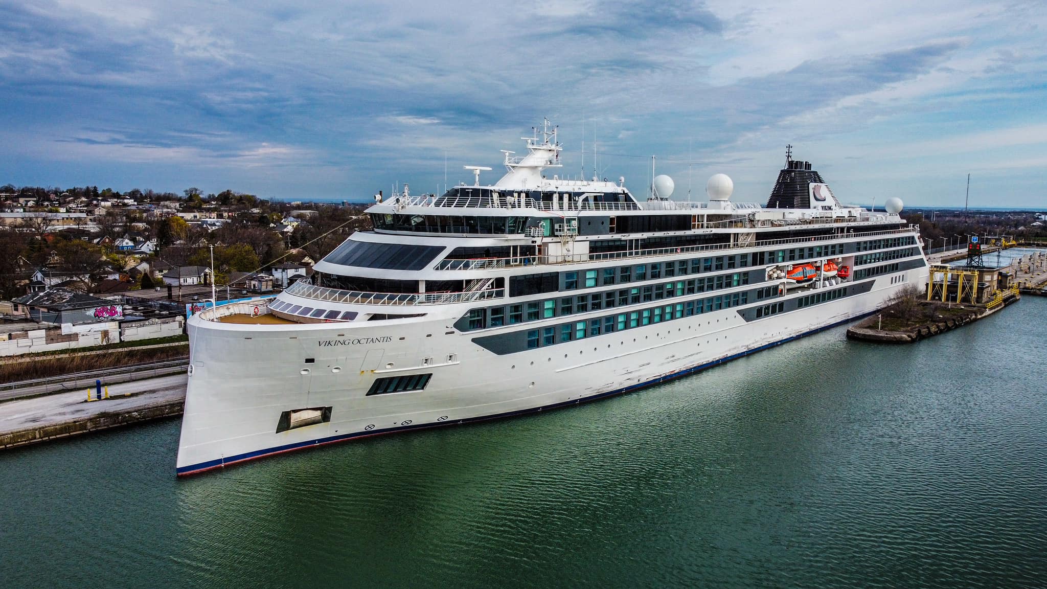
I've come across several photos of the
Viking Octantis because it is the largest cruise ship on the Great Lakes and attracts ship fans wherever it goes. I have seen enough photos that I'm promoting it to its own notes. Its popularity effectively makes this an index of the St. Lawrence Seaway and Great Lakes.
 |
Janey Anderson posted
May 1 - 7:30 am VIKING OCTANTIS UPDATE Heading up the Welland Canal. Has arrived in Port Colborne!! Amazing Photo Credit hot off the press:
Janey Anderson: Martin Ridland there is no schedule in the canal, as my Pilots always say. She'll take as long as she needs to in order to transit safely. |
This is a good view of the reverse slant of the bow. Carl Burkett
commented on his photo: "With her patented Ulstein inverted X-BOW,
OCEAN EXPLORER will cleave the waves in such a way that internal noise and vibration is reduced and the hull's shape reduces slamming against the vessel with little spray on its deck." [
Dennis DeBruler] Thus the comfort of the passengers is more important than efficiently cutting through the water. (Update: actually, the "backslash" bow is also more efficient. [
ferussmit])
 |
| Tanya Ward commented on Janey's post |
 |
Tanya Ward commented on Janey's post
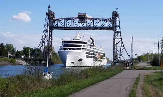
[According to some of the comments, this is Allanburg Bridge.] |
 |
Randi Klein commented on Bobby's post
We were onboard Viking Octantis NY to Toronto, so thanks for all the photos! The Captain and pilots masterfully sailed us thru all those narrow locks .
[The above screenshots of the ship going through a lock was of Lock 8, which is a guard lock and it has a low lift because its purpose is to accommodate fluctuations of the height of Lake Erie. This photo shows that the more normal lift lock would scrape a different part of the ship and it is an even tighter fit.] |
 |
Jim Hutchinson commented on Bobby's post, cropped
Here is the girl heading out of Port Colborne as I was walking into Northland Point Senior Home to see my Dad. |
 |
Another photo from Bobby Dzz's post of 10 photos
Brian Lüders: Lots of scrapes and scratches
[Note the thruster icons near the water level. It evidently has three bow thrusters. Given the short, straight guide wall on the river side of the lock, I think it is coming out of the upbound Lock 6.] |
 |
May 13, 2022: Kathie Timpano posted
Here we have the stunning Viking Octantis making her return trip northbound thru the Welland Canal at Bridge 11. So happy I was able to see her in person this afternoon.
|
 |
Sandi York posted
Today [May 26, 2022] the Viking Octantis cleared the locks on her way to Lake Superior.
[There were quite a few photos of its maiden voyage up the St. Marrys River. I chose this shot because of the railroad bridge in the background and a good view of its "backslash bow."] |
This ship was designed and built to be as big as possible but still fit in the locks of the St. Lawrence Seaway. It is a tight fit and I read that it was scratched by the time it arrived at the
Eisenhower Lock. It looks like the design includes some sacrificial scratch rails. Note the scratches on the bottom rail in this screenshot.
%20Facebook.png) |
4:24 video @ 0:33
Viking Octantis, tight fit going into lock 8 Pt. Colbourne. |
Are some of the scratches from tugs?
I doubt that a tug is creating these long, skinny scratches. This view reminds me that the bow of a tug has a lot of padding.
Some of the scratches are below that rail.
I wonder how small the gap is on the other side when this gap got bigger. Since this is near the stern, I'm guessing the gap is bigger because the ship is getting a little narrower.
I wondered if a ship designed for the Seaway would have thruster. This symbol indicates that it has a stern thruster as well as a bow thruster. In fact, I think the propwash we see in this segment is from the truster.
 |
1 of 3 photos posted by Lincat Photography
I caught the Viking Octantis in the Detroit river earlier in the week and got some nice shots of her as she docked with the Gordie Howe bridge in the background.
Mike Mishler shared |
 |
Brad Wood Photography posted
"In with the new and out with the old". This morning, one of the oldest ships, the S.T. Crapo, came into Port Colborne, Ontario, Canada, to rest and end its 95-year journey. As it approached, from out of the dark, came the Great Lakes newest and largest cruise ship, the Viking Octantis. It swiftly sailed past the, once steam powered, S.T. Crapo and dropped off a group of modern explorers from, around the world, to discover Niagara. Times are certainly changing, and we seem to be in a rush to try and keep up! Imagine what the next 100 years will bring, and what it will leave behind!!!
Brad Wood Photography also posted |
Update: In 2023, I have been seeing photos of a sister ship: Viking Polaris.
 |
First of 10 photos posted by Tom Barker
Viking Polaris 1000islands |
And the
Octantis is back for the 2023 season:
 |
Alec Jacobson posted
Viking Octantis backing into Port Milwaukee on May 4, 2023.
Roger LeLievre shared
Timothy Johnson: I just wish the dock where they come in wasn't so run down and industrial.
[It is going under the Hoan Bridge.] |
 |
Clark Bloswick posted, cropped
Viking Octantis and Viking Polaris at Mackinac today.
Larry Burke: The Island has enough visitors and vacationers as it was now with the Cruise Ships it will further erode serenity and beautiful peacefulness of this gorgeous island. It’s nice to have the business and money but what you lose is it worth it?
Keith Stokes: Larry Burke Many more people come every hour on the ferries. Not much impact beyond looking good across the water. Grand Hotel alone holds more people than the two ships combined. |
 |
Jennifer Selinger commented on Amy's post
Watched it go through lock 3 last night! |
 |
Alain M. Gindroz commented on Amy's post
I met her above Lock 7. |
I Love Sault Ste. Marie, Michigan
posted three photos with the comment:
We LOVE our cruise ships and our tour boats!!!
Tuesday morning July 2, 2024.....
Pearl Mist in the
MacArthur Lock and the
Viking Octantis in the Poe Lock. And three different tour boats in front of the
Pear Mist.
-----
The Viking Octantis is 672'7" long and 77'1" wide.
Pearl Mist 325'2" long and 52’ wide.
 |
| 1 |
 |
| 2 |
 |
| 3 |


.jpg)


%20Facebook.png)


