Monday, January 31, 2022

1931,1954+2023 US-60 Bridges over Ohio River at Smithland, KY

1931: (Bridge Hunter; Historic Bridges; B&TSatellite) Lucy Jefferson Lewis Memorial Bridge
2023: (The truss is still being built in Jan 2022)

This bridge was designed by Modjeski & Masters and has a 500' main span.
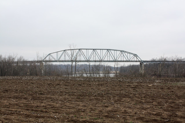
C Hanchey Flickr, License: Attribution-NonCommercial (CC BY-NC) 

Lucy Jefferson Lewis Memorial Bridge

Historic Lucy Jefferson Lewis Memorial Bridge on U.S. Hwy 60 over the Cumberland River in Smithland, Livingston County, Kentucky. The Warren through truss bridge was built in 1931 by the Nashville Bridge Company.


This post alerted me to this bridge replacement project:
Marcus Hinman posted two photos with the comment: "M/V Miss Deanna and M/V Maverick topping the bridge around this afternoon in Paducah."
David Miller: Is that the bridge that's going up on the cumberland?
Dennis DeBruler: David Miller To where?
David Miller: Dennis DeBruler smithland
1

2

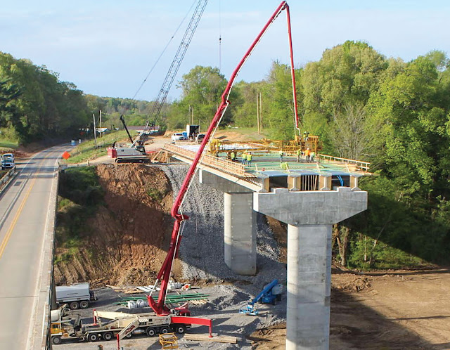
Obviously, the approach spans for the old bridge used steel girders whereas the spans for the new bridge use concrete girders.
Aug 2021 Patrick Gurwell Photo via BridgeHunter

HeraldLedger, Kentucky Transportation Cabinet
$63.6 million contract awarded for U.S. 60 bridge at Smithland
[The article called it a "continuous truss." But a truss with just two piers can't be continuous.]
"Initial work at the site will include a significant maintenance project on the existing 89-year-old structure."

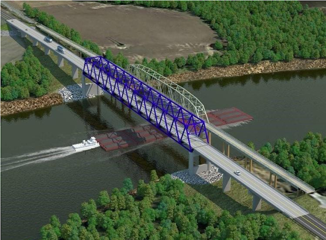
The new span is 700' long and the deck is 40' wide with two 12' lanes and 6' shoulders. That will allow most farm equipment to share the bridge with other vehicles. (The old bridge is 20' wide. Some farm equipment would fill up most of that width.) [wspd, this article also has a time-lapse video of the construction.]

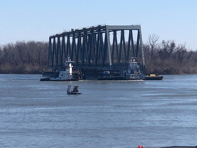
Jan 7, 2022: WaterwaysJournal-rotate
The steel truss of the new $63.6 million Cumberland River bridge rotates in the Tennessee River just off-shore from the Paducah-McCracken County Riverport Authority. The truss must be turned six times during construction. It will then be floated to Smithland, Ky., for installation. (Photo by Scott Swamback/American Bridge Company)
[The 40' wide deck is in a 48' wide truss.]
"Jim Smith Contracting Company and American Bridge Company chose the Paducah-McCracken County Riverport Authority as the construction site in August in part because of the capabilities of its Comansa tower crane. The site is also rarely affected by high-water conditions, allowing work to continue even when Mother Nature might otherwise interfere. The first piece of structural steel was placed September 9."
[This project is evidently too small for the American Bridge Co. to mention on its web site.]
 
This must be the "Comansa tower crane."
Street View

Kentucky Transportation Cabinet via WaterwaysJournal-started
The drilled shafts under the main piers are 80' long and 8' in diameter.


Image via BridgeHunter

Image via BridgeHunter

I zoomed out and save a satellite image because it caught the river in a flood stage.
Satellite

I better get some street views while I can.
Street View

Street View

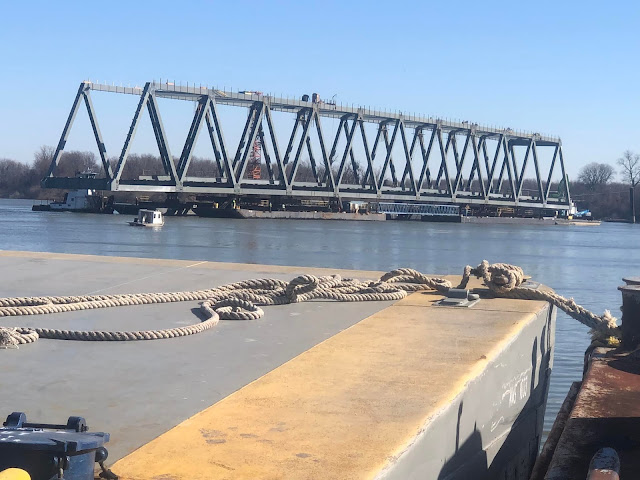
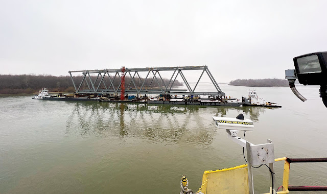
Sep 14, 2022: West Kentucky Star posted
It took a little longer than expected, but the 700 foot bridge truss spanning the Cumberland River in Smithland is in place.
Adam Freeman: Is it the same width as the other bridge? Does it have a shoulder?
Gayron Ferguson Jr.: Adam Freeman The new bridge has a truss design similar to that of the U.S. 60 Tennessee River Bridge at Ledbetter. It will have a 40-foot-wide, two-lane deck with 12-foot driving lanes and 8-foot shoulders that will provide ample clearance for most farm equipment to cross without stopping oncoming traffic.

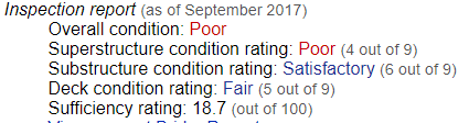
Bridges & Tunnels posted
One of the few remaining truss bridges in Kentucky funded by the Murphy Toll Bridge Act of 1928 will soon be demolished. The Smithland Bridge was completed over the Cumberland River for US 60 in 1931 and was originally tolled with revenues being used to pay off its construction bonds.
In 2017, the Kentucky Transportation Cabinet selected a consultant to study possible options for replacing the Smithland Bridge. The state determined that the structure was functionally obsolete because of its narrow deck width of 20 feet and its structural deficiencies. KYTC began preparation work for constructing the new Smithland Bridge in June 2020 and work on the new near-$64 million crossing began shortly after.
The American Bridge Company began work on the 700-foot main span at the Paducah-McCracken County Riverport Authority on the Tennessee River in July 2021. The truss was assembled atop seven barges and then floated 14 miles upstream on the Ohio and Cumberland Rivers to Smithland. Hydraulic lift towers jacked the main truss into place in mid-September 2022.
The new Smithland Bridge is scheduled to be opened in December 2022 with the old bridge to be demolished between April and June 2023.
➤ Check out more photos and a video of the Smithland Bridge at http://bridgestunnels.com/location/smithland-bridge/

1:40 video @ 0:18
Smithland Bridge - Driving Tour

Sunday, January 30, 2022

Four New Bridges for a new Villers Island In Toronto, ON

(Satellite)


Janey Anderson posted
TODAY'S 2021 HOT PIC GOES TO DAVE YAGER TRANSITING BEAUHARNOIS LOCK ON MCKEIL TUG LOIS M.  All the Toronto bridges coming from Halifax brought excitement to the Seaway, but the second one with Captain Dave Yager on the lead tug Lois M. was a real crowd favourite. He says he "never minds honking for kids or Junkies". And the fun thing about Dave is, we never know what McKeip ship or tug he'll be on next! Cheers Dave - thanks for all the good times in 2021!
We welcome your 2021 pictures of the Toronto bridges in transit!

Before discussing why there is a bridge in a lock, I need to provide some background information about a waterfront project in Toronto that requires four new bridges. Toronto is putting a river back into its waterfront to reduce flooding and to turn an "underused" industrial area into "25 hectares of publicly accessible greenspace and parkland." [PL-about] The best way to understand the project is to look at before and after images. Unfortunately, the east/west dimensions of their map don't match the satellite image so I can't get an exact comparison. But you can see the new kilometer-long river valley with a new mouth for the Don River that is going to be dug between the Keating and Ship Channels. As part of the project, they are building a new Cherry Street west of the existing street.

Satellite, before

Map, after

Their spin on the cost is that it "will contribute over $4 billion to the Canadian economy." [PL-why]

This image finally helped me understand why they would dig a river. The parkland is a side-effect of the development. More prime real-estate near downtown is the real reason. They want to create a flood-free Villers Island for a bigger downtown. This image also shows the four new bridges that are needed to provide access to the new Villers Island.
PL-why, thumbnail

It is a little disconcerting that the same web site has different images of what the new river should look like. Since this plan would require five bridges, it must be an obsolete plan.
PL-details, thumbnail

An even more recent diagram has only three crossings to the island.
Details via PortLandsTo

The Jan 2022 satellite image still has the old trunnion lift bridge, but some photos of the replacement bridge have been uploaded.
Satellite

Safwat Ghabbour, May 2021

But they are still building the new Cherry Street so the old trunnion bridge is still being used.
Android Dave, Aug 2019

Janey Anderson posted three photos with the comment:
More News for Opening Day - McKeil Spirit is delayed leaving Toronto due to a problem with the bridge.
She's been laid up at Leigh cement in since 28.02.22 and expected to leave for Picton possibly Friday as long as the parts for the bridge arrive - TBC.
The Cherry Street Strauss Trunnion Bascule Bridge is located in the Port Lands and carries Cherry Street over the Toronto Harbour Ship Channel. It has to open to allow ships to access the channel and the turning basin beyond.
The bridge was built in 1930 by the company of Joseph Strauss and the Dominion Bridge Company. The north side of the bridge has 750-ton concrete counterweights that allow the bridge to pivot to open.
The city spent CA$2.5 million to refurbish the bridge in 2007. The Toronto Port Authority made further repairs from December 2012 to September 2013 at a cost of CA$2 million.
22.03.22
Leslieann Lafosse: Where are those new sections that sailed up from Dartmouth going, is it not down around there somewhere?
1

2

3

Dennis DeBruler replied to Leslieann's question
One of the four bridges will replace this one and another will carry Cherry Avenue across the new river that they plan to dig.
https://portlandsto.ca/why-this-matters/
I'm wondering what is going to happen to the cement facility.

This photo of the new bridge from the old bridge shows that it is still up on its jacks after it was floated into place.
Alex Dunn, Nov 2020

June 11, 2022:
Janey Anderson posted
Tonight I snapped a pic of the very first Cherry Street North LRT bridge for the new $1.25 billion Villiers Island project in Toronto, which arrived from Halifax in Feb. 2021
Another one is in its way soon.
The bridge will come via tug Beverly M1 and barge Glovertown Sprit in a few weeks.
This is the Cherry Street Bridge "Center" span. The Cherry Street bridge was delivered in 3 pieces.
Stay tuned for updates.
Annabelle Né: It was exciting to see it going through the locks. Thanks for showing us what it looks like once in place Janey!

A snapshot when only one of the four bridges has been installed, but they have made good progress on the new river channel.
WaterfrontToronto

It looks like the southern part of the Port Lands including the Port of Toronto will still be available for industrial work.
Janey Anderson posted five photos with the comment: "Tug Radium Yellowknife with Coastal Titan barge offloading huge transformers (using both cranes) from Sloman Discoverer at Port of Toronto and taking to base of CN Tower (powering Toronto). Photos taken by Jeff Harding on RY tug. 06.10.22"
1

2

3

4

5

Some photos my daughter took while riding through Toronto in July 2022 because she knows that I'm interested in bridges and these struck her as special.
1

2

3

3:51 video about the four bridges

5:20 video updating the construction in 2021
3:51 video May 2022 update

The photos concerning the transport of the fourth bridge to Toronto have been moved to here.

Saturday, January 29, 2022

A Corten Bridge Collapsed in Pittsburgh, PA at 6:30am, Jan 28, 2022

(Bridge Hunter; Satellite)

(Jul 2023 Update: When I discovered that a new bridge in Indiana was going to be built with Corten, I checked out the NTSB status of the investigation of this collapse. The last report was Jan 2023, and they were still investigating.)

There were no fatalities even though there were cars and an articulated bus on the bridge when it fell.

Street View

Brian Shields posted four photos with the comment: "BREAKING NEWS: Bridge collapse in Pittsburgh. Injuries reported. Info just coming out… (Forbes Ave. Bridge)"
[This post has 13K comments. I didn't read them.]
Vince Diventura shared
1
[Note the posted load limit of 26 tons.]

2

3

4

But this comment did catch my eye.
Dawn Renee commented on Brian's post
Yeah, they knew that bridge was damaged for years. So scary.
[So the bridge inspectors and repair engineers didn't think that diagonal member was carrying any compression forces? Cables help only with tension forces.]

Richard Butterworth commented on Brian's post
The average fully loaded articulated bus weighs between 28 to 32.5 tons. With a bridge weight limit of 26 tons, the bus probably shouldn't have been there in the first place.
[I wonder what the fine print for "load limit" is. That is, 26 tons in how many feet? An articulated bus may be long enough that it legally spreads its weight out over the bridge.]

"Design: Batter-Post steel rigid frame, constructed from weathering steel (also known as Cor-Ten (Corten) steel)" [BridgeHunter] Some BridgeHunter comments indicate that Cor-Ten has proven to have a problem with salted roads.

The Chicago Tribune reported that the most severe condition of those hospitalized was "fair." I'm not going to bother to read any more of the media reports since I know there were no fatalities. I'm sure they will report the accident is under investigation. I will record the NTSB URL that Nathan Holth provided in BridgeHunter, https://www.ntsb.gov/investigations/Pages/HWY22MH003.aspx, so that eventually I can access some real information.

I capture the rating of the bridge so that I can compare it to the I-80 bridges in Joliet, IL.
BridgeHunter

I-80's report:
BridgeHunter-I-80

If this collapsed bridge was "just" poor, then why are vehicles still allowed to drive over a bridge that is Critical? Especially since normally there is a continuous line of trucks over the whole bridge because of the intermodal yards south of Joliet and the congested traffic on the bridge. Secondly of all, how can the individual numbers for I-80 be worse than the Fern Hollow Bridge but the Sufficiency Rating is more than three times better? If the trillion dollars is allocated based on Sufficiency Rating, then I-80 is screwed. (I had seen a Sufficiency Rating of 6, which is "intolerable." Who changed the 6 to 60?)

Friday, January 28, 2022

1929,1982 NS/Southern Bridge over Great Ship Lock Canal in Richmond, VA

(Bridge Hunter; no Historic Bridges; no B&T; 3D Satellite)

"Built by Southern Railway 1929, gears removed and bridge welded into place 1982." [BridgeHunter] "The lift bridge...was built by the Norfolk and Southern Railroad in 1929 to serve the paper mills along the Pamunkey River at West Point." [hmdb

3D Satellite, looking South

Royce and Bobette Haley 2017 Photo via Bridge Hunter

Stanley Short posted
We are in Richmond, VA on March 9, 1991, looking through the Norfolk Southern bascule bridge on their line to West Point. Running westbound on the former C&O James River Viaduct is eastbound CSX manifest R300 with two C40-8's. Confused? Q300 came eastbound into Fulton Yard on the former C&O. Once at Fulton, the power ran around the train and headed back west to Rivanna Junction and the former C&O Piedmont SD, and then ran a short distance to AM Junction where it headed north on the former Seaboard to South AY interlocking on the RF&P. There it turned south on the former ACL enroute to Portsmouth, it's final destination. Add to that, helpers are required between Fulton and South AY interlocking. This move is still performed several times a day with everything from manifests to unit coal and grain trains. Photo by Stan Short.
Randall Hampton shared
Nobody ever shows this area from this angle.
Vincent Corbo: Probably because of the now present no trespassing sign.

I discovered this bridge while researching the CSX/C&O James River Viaduct.
Dennis DeBruler

The preserved lock that is just 200' downstream from this bridge was built from 1850-54. [Great Shiplock Park]
Satellite