Showing posts with label bridgeGirderConcrete. Show all posts

Tuesday, September 9, 2025

Robert E. Lee Bridges over James River in Richmond, VA

1933: (Archived Bridge Hunter; Bridge Hunter)
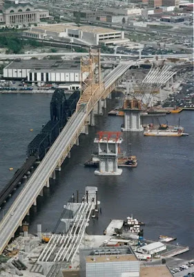
Belle Isle Suspension Bridge: (Satellite) This bridge is under the 1989 bridge.

1933 Bridge


Tichnor Brothers Collection via BridgeHunter

Walt Edward posted
Richmond, Va during the flooding from Hurricane Agnes, August 1972. That’s the Lee bridge and the C&O main to Newport News in the background.

Postcard via BridgeHunter

Courtesy of Library of Virginia via BridgeHunter

Courtesy of VCU Libraries via Bridge Hunter

1989 Photo by Billy Pickett via BridgeHunter
"bridge's last day"

Courtesy Richmond History Center via BridgeHunter
[They have started construction of the replacement bridge.]
.

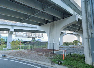
1989 Bridge


 David Waltenbaugh, May 2018

Street View, Apr 2014

The old piers just to the left of the new piers were for a truss bridge that provided a service road to the Old Dominion Iron & Nail Works that was on Belle Island.
Street View, Apr 2014
.

Belle Isle Suspension Bridge


In 1991, they hung a pedestrian bridge from the main bridge.
Street View, Mar 2020

Lisa Slate, Sep 2022

Thursday, August 28, 2025

2000 Covered, US-40 and CSX/Pennsy Bridges over Embarras River west of Greenup, IL

Covered: (Archived Bridge Hunter; Bridge Hunter; Satellite)
US-40: (Satellite)
CSX/Pennsy: (Archived Bridge Hunter broken link; Bridge Hunter; Satellite)

I found this covered bridge on a satellite map when I was researching the Pennsy Greenup Depot.
Street View, May 2025

Street View, May 2025

Note the use of metal gusset plates. That is not historic. But that is a worthwhile compromise of historical integrity to allow IDOT to build the "longest single span timber bridge in the United States with no posted weight limit." [see Digitally Zoomed below]
Street View, May 2025

When I was getting the street views, I noticed that US-40 itself is historic. Note that most of the bridge is over a flood plain.
Street View, May 2025

And it has seen some wear and tear. This is another view of the flood plain on the east side of the channel.
Street View, May 2025

Most of the street views show that the river level is normally low.
Street View, Sep 2023

Since I just had to turn 180 degrees to find this bridge, I include this railroad bridge.
Street View, May 2025

Covered Bridge


2009 photo taken by Robert Stephenson via BridgeHunter
"Built 2000 as a replica of an 1832 bridge built at this site"
This 200' (61m) long bridge has a span of 191.5' (58.4m).

This source as well as BridgeHunter label the design as a Burr Arch. But some comments on ArchivedBridgeHunter disagree. Just because a bridge has an arch doesn't mean it is a Burr Arch design.
GalenfrySinger

Lynne Briggs, Sep 2024

Digitally Zoomed

Cumberland Road and US-40 Bridges


What I thought was the US-40 bridge in Bridge Hunter is really a Cumberland Road Bridge over a side stream of the Embarras River. So, I don't know when the US-40 bridge was built.

These photos are of the Cumberland Road Bridge.
2007 photo by Robert Stephenson via BridgeHunter

2021 photo by Steve Conro via BridgeHunter

A 1920 concrete girder bridge was very historic because concrete construction was still bleeding edge back then. But I had to use the past tense because it has obviously been replaced since Steve's photo was taken in 2021.
Street View, May 2025

Thursday, August 21, 2025

1908+2022 Cobban Bridge over Chippewa River near Cornell, WI

1908: (Archived Bridge Hunter; Bridge Hunter; Historic Bridges; HAER)
2022: (Satellite)

HAER WIS,9-ART,1--1, cropped
1. LONG VIEW OF BRIDGE, LOOKING SOUTH - Yellow River Bridge, Spanning Chippewa River on County Trunk Highway TT, Cobban, Chippewa County, WI

These were the last two Pennsylvania trusses in Wisconsin that the DOT destroyed. [HistoricBridges]

HAER WIS,9-ART,1--2
2. ELEVATION, LOOKING WEST

"Between 1916 and 1918, the Wisconsin-Minnesota Power & Light Company built a hydroelectric dam four miles downstream from the bridge, putting the site under water. The townships of Eagle Point and Arthur arranged to have the 486-foot span dismantled and re-erected 15 miles upstream near the village of Cobban." [HAER_data]

Photo by Theresa Catherine via BridgeHunter

2009 photo by Steve Conro via BridgeHunter

Nancy Lee Forster posted
One of Wisconsin's oldest truss bridge near Cornell on Hwy 178 will be torn down in 2022. The historic Cobban Bridge is now permanently closed. Take a road trip and take photographs while you can.
photo by 📷David Hoff

Girder bridges need more piers. I'm guessing they are concrete girders because no DOT uses white paint on steel girders. 
Street View, Oct 2024

Friday, August 15, 2025

1926+1957+2007 FL-789 John Ringling Causeways over Sarasota Bay in Sarasota, FL

1926: (Archived Bridge Hunter, broken link; Bridge Hunter)
1957: (Archived Bridge Hunter, broken link; Bridge Hunter)
2007: (Satellite)

Boat View, Feb 2019

Drone View, Jan 2022

Peter Moreno posted three photos with the comment: "The John Ringling Causeway in Sarasota Florida."
1

2

I'm guessing it uses concrete box girders.
3

This confirms that it is a concrete box girder bridge.
cdr-eng, 1 of several photos
The 3,100' (945m) long bridge is the primary hurricane evacuation route for the barrier islands. 
"At over 106 ft in width, the Ringling Causeway Bridge set a new record at the time of completion as the World’s widest segmental concrete bridge. The bridge structure consist of a multi-cell post tensioned concrete box girder with spans of about 184 feet [56m] to about 300 feet [91m], supported by reinforced concrete piers and footings on drilled shafts."

BridgeHunter_1926, Boston Public Library

BridgeHunter_1957

Friday, July 25, 2025

1921+1994 Ascota Bridge over St. Johns River in Jacksonville, FL

1921: (Archived Bridge Hunter; Bridge Hunter, no Historic Bridges)
1994: (no Bridge Hunter; no Historic Bridges; Satellite)

The full name is St. Elmo W. Acosta Bridge. He was the councilman who secured the funding for the 1,645' (500m) bridge. The 1921 bridge was the first one built across the St. Johns River. [SevenBridges]

"More simply called the Acosta Bridge named after the City Councilman instrumental in funding the original span known as the St. Johns River Bridge (1921). After Acosta died, the St. Johns River Bridge was renamed in his honor. Eventually, the new Acosta Bridge opened in 1994 replacing the older one. Today the Acosta Bridge has 6 lanes for cars, 2 pedestrian walkways, and 2-tracks in the median for the Skyway train. This is my favorite bridge on driving tours because of the magnificent view of Downtown from the crest." [VisitJacksonville, this is a summary of the main bridges]

Postcard via BridgeHunter

1924 photo via Pinterest via BridgeHunter


jaxhistory
"One hundred years ago, July 1, 1921, the Acosta Bridge was opened as the first span over the St. Johns River to move automobile traffic from one bank to the other."
Bridges Now and Then posted
"Jacksonville, Florida's, St. John's River Bridge opening day, June 1, 1921. Known as the St. John’s River Bridge, it was a toll bridge and an annual “pass” was available, which consisted of a tag or plate for the front of the vehicle. Tolls were taken up until 1940. The bridge was renamed the Acosta Bridge in 1947 in posthumous honor of St. Elmo W. Acosta, the city commissioner who championed the funding for the automobile and pedestrian bridge after World War I." (Jacksonville History Center)

Bridges Now and Then posted
July 1, 1921: Motorists and residents of Jacksonville, Florida celebrate the opening of the St. Johns River Bridge (later renamed Acosta Bridge). (Jacksonville Historical Society)

Jacksonville
The tolls were retired in 1940.
 
Jacksonville, this webpage has a lot of photos of the old bridge.
"April 1991: Construction of what would later become the northbound lanes of the new Acosta Bridge is under way. Once completed, the old Acosta Bridge was demolished and a second bridge was constructed that would eventually become the southbound span.   M. Jack Luedke/Florida Times-Union"

Street View, Jan 2022

The approaches look like steel girders.
Street View, Jan 2022

But the mainspan looks more like a concrete box girder. (I wish Bridge Hunters would cover modern bridges that aren't just plain girder bridges.)
Street View, May 2018

SevenBridges
"The new bridge features a box girder design; it utilizes pre-stressed concrete, making it much more reliable than its predecessor....The bridge is notable for allowing bicycle traffic in its commuter lanes. Between this, the sidewalks, and the Skyway rails, the Acosta Bridge is one of the most pedestrian-friendly bridges in the city. Just as the bridge offered the first path across the bridge for vehicle traffic many years ago, with its pedestrian-friendly design it continues its tradition of being ahead of the curve." It had been lit with neon lights, but they died in 2016.

DownTownJacksonville
"The new LED system cost $2.6 million and was installed by Miller Electric."