Showing posts with label towboat. Show all posts

Sunday, June 8, 2025

1859 UP/T&P Morely Bridge over Port Allen Canal near Baton Rouge, LA

(Archived Bridge Hunter; Bridge Hunter; Satellite)

T&P = Texas & Pacific

This bridge is the first bridge downstream from the Port Allen Lock.

2016 Photo by C Hanchey via BridgeHunter

MorleyMarina
The bridge was bult in 1959 as part of the Gulf Intracoastal Waterway, "a 1,050 mile inland channel running from Carrabelle, Florida to Brownsville, Texas."

MorleyMarina
"On Sunday, September 16, 1973, however, something went horribly wrong.
"As engineer Gerald Morrow raced his 100-car Texas and Pacific train from New Orleans to Shreveport, all signs indicated that the Morley Bridge was in the proper position for his crossing. What he didn’t know is that a power failure had hit the bridge while it was in raised position, and the bridge tender was unable to start a gasoline backup engine that would enable him to lower the bridge allowing safe train passage. Neither Morrow or the bridge tender knew that the automatic derailer located about two miles from the bridge, which is supposed to automatically derail any oncoming trains when the bridge is raised, was not working.
"When engineer Morrow and his brakeman, William E. Smith approached the bridge at full speed late that Sunday night, they saw that the bridge was in raised position and applied the train’s emergency brakes, but, by then, it was too late. The two engines and 16 cars plunged into the Intracoastal canal. Morrow and Smith, who were both in the lead engine, were buried beneath the other cars in 30-35 feet of water. Fortunately, none of the train cars contained chemicals or other dangerous cargo."
[In addition to the gas engine and derail failure, the railroad's signalling sysem had a big failure. It should have been fail safe and not provided a green signal if the lift span was not properly locked in the down position.]

D&S Marine Service posted 1:29 video
M/V Darian Alexandra passing through the Morely Railroad Bridge.
...


Saturday, May 24, 2025

1973 100mw Ozark-Jeta Taylor Lock and Dam on Arkansas River near Ozark, AR

(Satellite)

Street View, Feb 2024

"The Ozark-Jetta Taylor Lock and Dam is approximately 2,500 feet (762 m) long, 42 feet (13 m) high and has a structural volume of 120,000 cubic yards (91,747 cubic metres). The reservoir has a normal storage capacity of 129,000 acre-ft (159,119 Ml) and maximum capacity of 148,400 acre-ft (183,048 Ml). The dam has a 750 feet (229 m) wide controlled spillway with a maximum discharge capacity of 570000 cubic feet per second (16141 cubic metres per second)." [DamsOfTheWorld]

USACE_photo, Tomas Rofkahr
"Headed down the Arkansas, a barge locks through at the Ozark-Jetta Taylor Lock and Dam. Located at mile 308 of the river, the Ozark lock and dam is just one unit of the McClellan-Kerr Arkansas River Navigation System (MKARNS) that originates at the Port of Catoosa in Tulsa, Oklahoma. Running southeast through Oklahoma and Arkansas to the Mississippi River, the MKARNS ensures a 9-foot navigable channel for commercial barge traffic. The MKARNS is a 'high-use' waterway system that routinely sees more than 10 million tons of traffic a year."
[I wonder why the towboat is pushing on a side barge instead of the center barge.]

The photo above shows that the locks have the standard width of 110', but it must be longer than 600' to take 9 barges and a towboat. I include the scale in this satellite image because it implies the lock is 800' long.
Satellite

dvids
"Ozark Lake covers 10,600 acres of water area at Mean Sea Level (MSL) elevation 372.0 feet. A land area of 6,349 acres surrounds the lake and extends around the shoreline for a distance of 173 miles."

The power plant was built with five 20mw slant-axis turbines. A slant-axis turbine is a recent design that "allows more generation to be packed into a smaller area." But they have proven to be a maintenance nightmare. Rehab work started in 2005 and several problems were encountered which stretched out the rehab work to 2021. One of the problems was construction---the 26' (8m) water passages were not "centered."  "The solution, in this case, was to develop a massive reverse lathe/boring bar to go through the slow and exacting work of scraping out and milling the water passage. It was a huge task – and one that they found themselves having to do five more times." [issuu, unfortunately, the links for the three photos are broken.]

May 2025 Flood


Note the hydraulic jump.
Facebook Reel

Monday, March 24, 2025

1951,1981,2015 Mansfield Bridge over Monongahela River at McKeesport and Dravosburg, PA

(Archived Bridge Hunter; Bridge Hunter; Historic Bridges; pghbridges;  Satellite)

This 1,934' (589.5m) long bridge has a main span of 500' (152.4m). [HistoricBridges]
The clearance is 65.3' (20m). [pghbridges]

Street View, Aug 2021

Boat View, Feb 2021

Plan via HistoricBridges
"Reportedly, this bridge was under construction by 1948 and was made from steel specifically sourced from the melted scrap of the Wabash Bridge."

HistoricPittsburgh
Aerial view of the William D. Mansfield Memorial Bridge

Jacob H. Ford Photography posted
Here's a shot I took last weekend, of a towboat, the Megan Ames traveling up the river, from near the old "Paule's Lookout" location, looking out over the valley. I shared a similar image from this same location last week, of just this towboat in a tighter frame traveling under the Mansfield Bridge, but this shot also includes U.S. Steel Irvin Works in West Mifflin, farther up the valley on the other side of Dravosburg. This shot has the perfect mix of industry, nature, and everything that the Mon Valley is known for, all in one frame. Enjoy!
Photo taken: March 15, 2025
📸: Jacob H. Ford Photography— in West Mifflin, PA.
 
Jacob H. Ford Photography posted
Here's a shot I took yesterday mid-morning in West Mifflin, from a stretch of the Mon Valley I hadn't captured in a little while, from one of my favorite locations in the valley near the old "Paule's Lookout" location near a parking lot along Skyline Drive in West Mifflin. This is a unique vantage point in the Mon Valley, because of how many different subjects you can see from here; including U.S. Steel Irvin Works on the right atop the valley-side framed in the tree branch, the Mansfield Bridge spanning across the Monongahela River in the middle of the frame, with Glassport and McKeesport on the left side of the bridge, and West Mifflin and Dravosburg on the other side of the river. In the top left of the frame, you can also see some unearthed soil from the construction from the new stretch of Route 43 that’s being built as well. 
I was fortunate enough to capture a towboat pushing a four barges down the river, while another towboat was traveling up the river as they passed each other under the Mansfield Bridge. The mid-morning lighting was perfect and created a vibrant composition, while the branches and leaves in the foreground allowed me do some creative framing in this scene. I have quite a few more images to share from my time in West Mifflin yesterday at this location, along with another unique location and subject in the Mon Valley that I have never captured before and actually took a tour of, so stay tuned for those a little later. Enjoy!
Photo taken: August 2, 2025
📸: Jacob H. Ford Photography— in West Mifflin, PA.
Jacob H. Ford Photography shared

HistoricPittsburgh
Construction of the Dravosburg Bridge

Tuesday, December 24, 2024

1966 Lincoln Trail Bridge over Ohio River between Cannelton, IN, and Hawesville, KY

(Archived Bridge Hunter; no Historic Bridges; Satellite)

The official name is Bob Cummings Lincoln Trail Bridge.

Street View, Sep 2024

Bryan Burton Photography posted
The Excell Marine Winchester heading towards the Lincoln Trail Bridge that crosses the Ohio River between Cannelton, IN and Hawesville, KY. 12/2024

BridgeHunter
This 2,708' (825m, half mile) long bridge has a main span of 825' (251m).
The average daily traffic in 2004 was 8,338.

Both sides of the river have high levees so I could not get non-profile street views. Fortunately, Valerie took some photos of the bridge.

Valerie Kastler, Jun 2018

Valerie Kastler, Jun 2018

Note the big prop washes. The towboat is pushing hard against a current because this was during the April 2025 flood.
Bryan Burton Photography posted
The Excell Marine Winchester heading towards the Lincoln Trail Bridge that crosses the Ohio River between Cannelton, IN and Hawesville, KY. 12/2024


Thursday, May 16, 2024

Barge Allides with 1960 Pelican Island Causeway on May 15, 2024, Causing an Oil Spill

(Archived Bridge HunterSatellite)

This bridge is the only vehicle access to the island. The rail bridge has not been used for a long time. No one was injured. Although two deckhands went into the water, but they were quickly rescued.

Keith Johnson, May 2024

abc13
It happened around 10:00am May 15, 2024. When you watch the video, you can see that there is a strong current flowing past the barge. There are no residents on the island [actually, there are a few] and Texas A&M already had their graduation.
"The Gulf Intracoastal Waterway is shut down for approximately 6.5 miles between marker 350.5 to 357 as officials respond to this incident, County Judge Mark Henry said, adding that the oil spill is heading in that direction, so the U.S. Coast Guard decided to move forward with the closure."

abc13
They reopened the bridge "allowing drivers to pass the bridge one by one, at about 20 feet apart." But at about 6pm evacuations were cancelled " because the bridge was 'unstable' and 'handrails and concrete were seen shifting.'" At 8pm, people were again allowed to leave the island, but no one could enter the island. Traffic to leave was still congested by 9pm.

abc13
"Officials told ABC13 that two crew members on the ship were either thrown or jumped off, but they were rescued quickly. Emergency management leaders confirmed with ABC13 that there were less than 200 people on the island when the incident happened. Vacuum gas oil is leaking from the barge, which has a capacity of 30,000 gallons and is operated by Martin Operating Partnership."
"The causeway itself is 3,239 feet long [987m] with a span of 164.1 feet [50m]."
Plans were already underway to replace the bridge because it was built in 1960 and "is at the end of its functional life." Construction was planned to begin in Summer 2025.

abc13
The barge broke loose from its towboat. One of the towboats in this image was handling the barge and the other had been sent to help retrieve the barge.
"Officials say the liquid is vacuum gas oil, a heavy oil byproduct of vacuum distillation of crude oil. Honeywell, who was not involved in this incident, describes VGO as 'a key feedstock for fluid catalytic crackers used to make transportation fuels and many other by-products.'"
 
I did find one photo on a page that was updated at 9pm that showed an oil boom deployed around the leaking end of the barge. [click2houston]


The railroad bridge is in the foreground.
Chloe Tess Tan, Jan 2024

Patrick Feller Flickr via BridgeHunter, License: Creative Commons Attribution (CC BY)

Douglas Butler posted
Pelican Island Bascule Bridge in the lowered position Houston Chronicle.
Douglas Butler shared

Street View, Mar 2024

Saturday, May 4, 2024

1917+1924+1991 Spokane Street Bridge over Duwamish Waterway in Seattle, WA

1917: (Archived Bridge Hunter) This was the third bridge built at this crossing.
1991: (Archived Bridge Hunter; Satellite, it is the northern bridge)
 
Bridges Now and Then posted
Seattle's Spokane Street Bridge, a double swing bridge, pretty neat, details in the comments. (Mark Yashinsky)
The bridge on the right is the Seattle West Bridge or High Bridge.

The two round piers are what allowed me to identify the swing spans.
Street View, Feb 2023

Unless you like the sound of the bell, skip to 1:00.
8:16 video @ 1:51
"It has a 480-foot (150 m) span....Each 7,500-short-ton (6,800 t) leaf of the bridge floats on a 100-inch (2.5 m) steel barrel in hydraulic oil. It is claimed to be the only bridge of its type in the world and it has received several awards for its innovation, including the Outstanding Engineering Achievement Award of the American Society of Civil Engineers in 1992."

I watch towboats handle barges, but not tugboats. Why is the barge dragging two chains?
@ 4:12
.

Repairs


The "Outstanding Engineering Achievement" seems to be a maintenance nightmare.

"As part of our proactive maintenance efforts, we carried out the initial phase of the Spokane St Swing Bridge Rehabilitation Program from 2020 to 2022. These efforts included injecting epoxy resin into existing cracks in the low bridge and adding carbon-fiber wrapping in several locations on both interior and exterior surfaces to strengthen the bridge." [sdotblog]

sdotblog_2023-09-25

It was closed three weeks starting Dec 23, 2022, to remove a cylinder for emergency repairs.
KOMOnews
"During the three-week closure, the department said crews removed a damaged 15,000-pound cylinder, repaired underground power conduit and replaced valves and hoses on the eastern bridge span’s hydraulic power unit." [In another article, SDOT says the cylinder weights 20,000 pounds.]

Here are SDOT's details about why it needed emergency repairs. The planned outage was for a week, but it ended up being three weeks.
The problem initially appeared to be associated with a computer issue that occurred while the bridge was powering back up after a power outage. Once the computer issue was resolved, engineers found previously identified minor issues with the hydraulic system that moves the bridge had intensified.

SDOT completes regular inspections of the Low Bridge and had existing plans to repair these aging components in 2023. However, after the power outage, it was discovered that previously manageable small-scale issues had escalated into more severe problems. Until these components are fixed, the bridge cannot be reliably moved without risking more severe long-term damage.

SDOT engineers are working as quickly as possible to analyze repair options. While there is not yet an estimate for how long bridge repair will take, SDOT expects the closure to last for at least two weeks.

Based on the evaluation results, additional Low Bridge closures for repairs may be needed in 2023, along with closures associated with planned capital improvements to the bridge next year.
One week in Oct 2023 to replace the cylinder.

One week of outage was planned starting Oct 7, 2024, to reinstall the overhauled cylinder and remove the second cylinder for refurbishment. 
mynorthwest, Photo from Seattle Department of Transportation
The bridge opens about four times a day.
They are confident that during the 3-week outage at the beginning of 2023 they learned how to remove and install a cylinder in 2-3 days per cylinder.

They learned their repair lesson well because the outage was just 3 days instead of the planned 7 days. 
SeattleBikeBlog, Image from SDOT
"The department did not say how crews achieved this early reopening, but perhaps they have gotten very good at fixing this odd pivoting bridge because it breaks down so often....More closures will be needed in the somewhat near future to repair the other cylinders and the control system, though dates have not yet been announced."

It closed Apr 19-28, 2024, for more maintenance.
yahoo and fox13seattle

The carbon-fiber wrap reinforcement is needed because cracks developed after just 3 decades of service. [kuow]

seattle
This webpage details the maintenance work for the 9-day Apr 2024 closure. 

This bridge is a violation of the KISS (Keep it Simple, Stupid) principle. I wonder how many multi-day outages were suffered by the Government and Fort Madison bridges after just a few decades.
.

1924


When built, the 1917 bridge was considered temporary with a lifespan of 10 years. This replacement bridge was the first one built with concrete and steel. [whereiamnow, a history of the bridges to West Seattle]

pauldorpat
"Rerouted westbound traffic clogs the 1930 West Seattle drawbridge during the afternoon rush hour of Monday, June 12, 1978, some 36 hours after the freighter Antonio Chavez rammed its companion 1924 span (right) and stuck it upward and beyond repair. (Greg Carter, West Seattle Herald, courtesy Robinson Newspapers)"
The first bridge was built in 1924, and the second one was added in 1930.
 
pauldorpat
"The 1924 span of the Spokane Street Bridge soon after the June 11, 1978, ramming stuck it open. The recently opened Kingdome is seen in the background. (Greg Carter, West Seattle Herald)"
West Seattle was organizing to succeed from Seattle so that they could get funds to build a replacement bridge. But a freight alliding with this bridge made succession unnecessary. [My notes on the High Bridge has more info about the allision.] It was replaced by the high bridge next to it. But in 1991, even the low bridge was replaced.
Douglas Butler posted
Spokane Street North Bascule Bridge was replaced crossing the Duwamish River in Seattle, WA source: Paul Dorpat.

chron, License: Creative Commons Attribution (CC BY)
 
Flickr, May 1, 1930, via BridgeHunter_1924, License: Creative Commons Attribution (CC BY)
Seattle Municipal Archives
Traffic on West Spokane Street Bridge, 1930
Item 4051, Engineering Department Photographic Negatives (Record Series 2613-07), Seattle Municipal Archives.
.

1917


Douglas Butler via BridgeHunter_1917


Sunday, April 14, 2024

Apr 12, 2024: 26 barges broke loose on Ohio River in Pittsburgh, PA

No one was injured, major infrastructure damaged nor hazardous materials involved. However, some marinas and docks along the river were destroyed.

Nine barges allided with the Emsworth L&D and six passed through. Some bridges were hit, but reopened after a few hours.

USACE, Pittsburgh District posted nine photos with the comment:
According to the Pittsburgh Fire and Police Department, at approximately 11:25 p.m. April 12, 26 barges broke loose on the upper Ohio River.
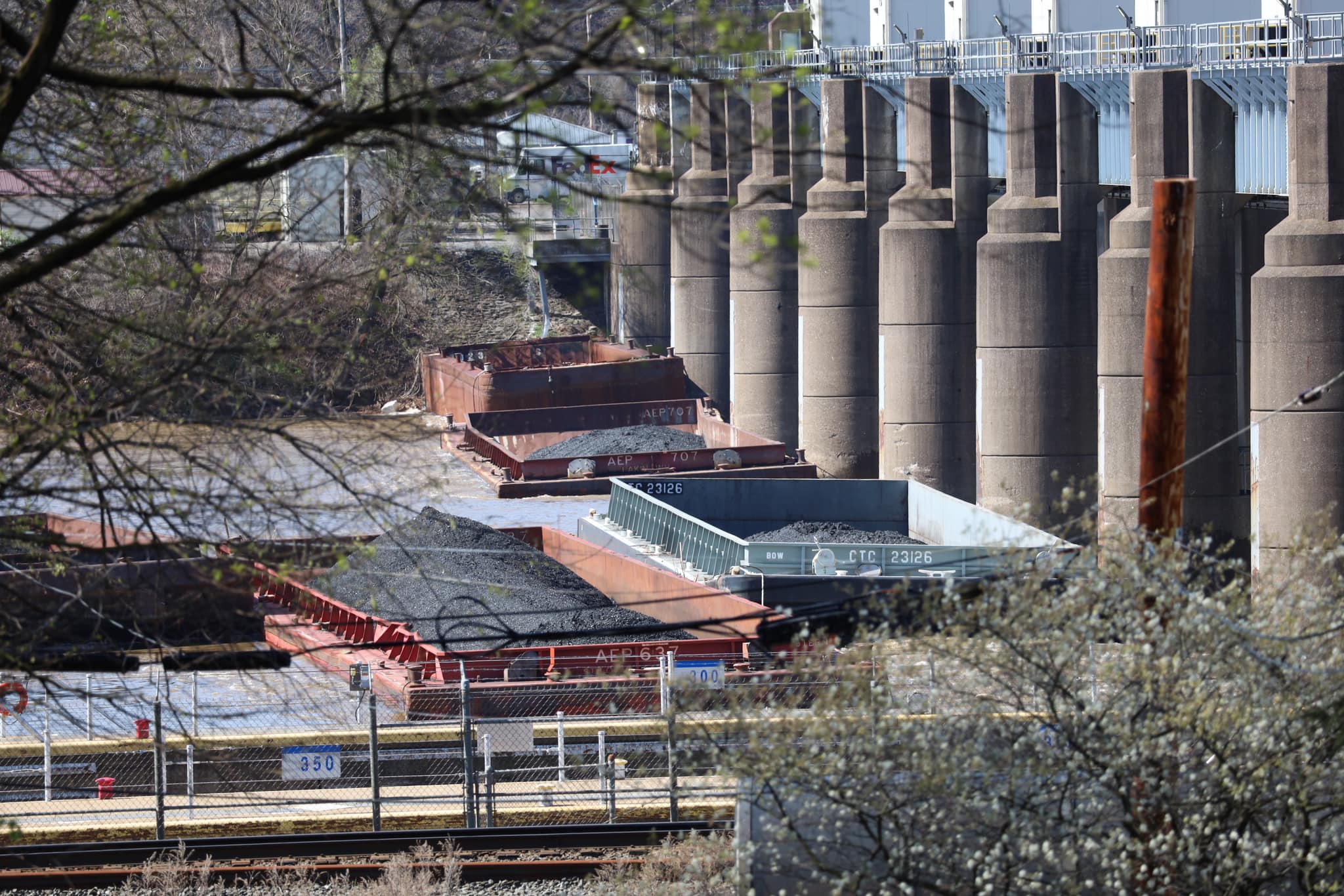
Eleven barges are secured by tugboat at Brunot Island. Nine barges came to rest at Emsworth Locks and Dam, with one being removed in the early hours of Saturday
morning April 13.
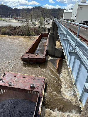
Four barges passed through Emsworth Lock and Dam and went over Dashields Locks and Dams in Moon Township, Allegheny County and have been retrieved and secured by tugboat. There is one unaccounted for barge.
The U.S. Coast Guard has overall lead for the response. The Army Corps of Engineers is inspecting our facilities for damage and are ensuring the safety of our employees and barge crews.
The navigation channel will reopen as soon as it can be done safely. U.S. Army Corps of Engineers, Headquarters
Melvin Lowe: Towboat not tugboat...there is a difference.
George Brkovich: It was bound to happen and to happen again. Oh yes let’s blame Mother Nature on this again and again. Thank God no one was hurt or loss a life, but the livelihood of Peggy’s Marina suffered damages. As a Coast Guardsmen and Army Corps Waterways inspector, I participated in many barge breakaway meetings. Before retiring I participated in one final meeting with Coast Guard, Industry leaders and ARMY Corps to discuss how prevent barge breakaways with better policing of fleeting areas. Well a lot of good discussion but nothing developed. For the most part the River Industry are responsible and hard working individuals and companies. But when it comes to Policing the fleets this needs to be revisited and acted on.
Mike Dumbaugh: Yeah, I seen that early this morning. They had to close Bruno Island rail BridgeWest End, Bridge in McKees Rockbridge.
Pickwick Lock shared with the comment: "In case anyone wonders how dangerous it is to work on or around the river, not to mention the dangers to our infrastructure. This is up on the Upper Ohio River, at Pittsburgh, PA. Towboats and crews will be needed to pull these barges off the infrastructure and back to safety. It is extremely dangerous work anytime, but is extra so in the high water."
Ron Bishop shared
1

2

3

4

5
[The barges under a gate would be the higher priority because if they don't get them out before the flood waters go down, they would lose the pool. Not only would navigation be lost, but loading and unloading barges would not be possible.]

6

7

8

9

Justin Thomas Jones commented on the USACE post
Barge Salvage? No problem give me a 📞

The Ohio River is flooded. I've seen a photo were all of the concrete at the Point was under water.
1 of 9 photos posted by the USCAE

safe_image for After breaking free on Friday night on the Ohio River, 26 barges now accounted for
"A spokesperson for the U.S. Coast Guard said 26 barges broke away from a vessel at mile marker one." [So a tow broke apart rather than mooring lines being broke by rising waters. Normally, it is a fleet of barges, not a tow, that breaks free.
(Update: having slept on it, the max size of a tow on the Ohio is typically 15 barges, so I think the barges broke free from a mooring instead of a vessel. So the USACE was wrong about tugboat vs. towboat and vessel vs. mooring, which are rather common and simple waterway navigation terms. If the USACE is this sloppy with English, what else are they sloppy with?)
(Another update: The Chicago Tribune had an article on this incident. The first sentence was: "More than two dozen barges broke loose from their moorings and floated down the Ohio River in Pittsburgh, striking one bridge that had already been preemptively closed and damaging a marina, officials said." At least that USACE source properly used moorings instead of vessel.)]

KDKA

KDKA

USACE, Pittsburgh District posted four photos with the comment: "UPDATE: There are currently seven barges that came to rest at Emsworth Locks and Dam. Earlier this afternoon, an empty barge sank and another broke away due to river conditions. This situation is still developing. We will continue to update. U.S. Army Corps of Engineers, Headquarters"
Darlene Reimond: I hope they didn't hit any of our bridges!
Lynn Tiwari: Darlene Reimond it was reported that the barges did wipe out a bunch of boat slips and at least one dock at Peggy’s Harbor, and about 90 boat slips downriver from there at the Branchport Boat Club. The Sewickley Bridge was hit and shut down earlier today but has since reopened.
Michael Camella: Darlene Reimond unlikely to cause significant damage.
1
[The barge must be hung up on the Dashields Dam, which is a fixed weir dam.]

2

3
Jackie Baker: Is that thing in the middle a barge that flipped?
Ryan Davila: Jackie Baker yes

4

James J Rogers commented on Photo #1
Dennis DeBruler: I've never before seen that many hydraulic jumps downstream of a fixed weir dam.

Shane Dixon posted five photos with the comment: "Loose barges & high water @ Emsworth & Dashields."
1

2

3

4

5

Apr 16: USACE, Pittsburgh District posted five photos with the comment: "Update: Campbell Transportation Company Inc., is currently in the process of removing five of the seven barges that came to rest on Emsworth Locks and Dams on the Ohio River at approximately 11:30 p.m. April 12. The recovery operation started at approximately 9:30 a.m., April 16, and is expected to continue until early afternoon. The operation is moving safely, and is being coordinated with the U.S Coast Guard and Pittsburgh District."
Bill McBride: Does Campbell pay to dock their barges in river across from Point Park.
JT Hardisty: Bill McBride Campbells owns the Pittsburgh landing across from the point.
[Campbell probably need to install floating bollards at their mooring site. 
Did they wait four days for the river to go down? Are the two remaining barges the ones that are stuck under the gates? They are the big problem.]
1
[That's interesting that they use a small towboat to get the rescue towboat into position.]

2

3

4

5
Marsha Zinnikas: Dangerous!
Justin Young: For sure once the hatches go under good luck