Showing posts with label rfHighsmith. Show all posts

Tuesday, April 16, 2024

Robert C. Byrd Bridge over Ohio River at Huntington, WV

(Archived Bridge Hunter; no Historic Bridges; 3D Satellite)

LC-DIG-highsm- 31758
Credit line: Photographs in the Carol M. Highsmith Archive, Library of Congress, Prints and Photographs Division.
Carol M. Highsmith's photographs are in the public domain.

Street View, Aug 2022

We Work the Waterways posted
Another good shot of high water in the Huntington,WV area. 
We can see the muddy wheelwash of American Commercial Barge Line's M/V RICH MCCARTY as she makes her way at Mile 308 on the Ohio River. 
The river just crested there this morning at 48.51 feet. It has risen 12 feet since Friday. 
Courtesy of Jeff Cumptan of Ohio & Kanawha River Photography.

Saturday, January 13, 2024

1891+1936,1990 South Side Bridge over Kanawha River in Charleston, WV

(Bridge Hunter broke Mar 22, 2023; Historic Bridges; HAERSatellite)

Street View, Mar 2022
 
LC-DIG-highsm- 31706 (ONLINE) [P&P]
The South Side Bridge over the Kanawha River in Charleston, West Virginia
Credit line: West Virginia Collection within the Carol M. Highsmith Archive, Library of Congress, Prints and Photographs Division.
Carol M. Highsmith's photographs are in the public domain.

We Work the Waterways posted
Here is something unique!
An infrared camera shot of the Charleston, WV skyline on the Kanawha River. Infrared blocks out most visible light and picks up light our eyes 👀 cannot see. It makes green leaves and foliage appear white. 
This photo was taken in mid-Summer. Let’s call it “WINTER IN JULY!” 
Courtesy of Gary Wendell  Photography.
Tom O'Dell: Great shot. The old Union Carbide Building is a historical landmark.

LC-USW3- 029724-D [P&P] LOT 844 
Charleston, West Virginia. A bridge over the Kanawha River
[I presume this 1943 photo is of this bridge.]

"The bridge is an extremely early example of a large truss bridge that has no v-lacing or lattice on its members." The length is "1,146.4 Feet (349.4 Meters)" and the main span is "420.0 Feet (128 Meters)."[HistoricBridges]
I don't normally include portal views because it is easy enough for a reader to get them. But I wanted to emphasize the modern holes-instead-of-lattice beams that Historic Bridges describes.
Street View, Oct 2021

Hailey Horn on behalf of Preservation Alliance of West Virginia, Billy Joe Peyton, and Clio Admin. "South Side Bridge ." Clio: Your Guide to History. March 15, 2017. Accessed January 11, 2024. https://theclio.com/entry/22828
"The South Side Bridge in Charleston, WV, was established as a result of the city becoming the state capital, and a sign of growth throughout the South Side. The bridge was completed in 1891, and allowed community members to cross the Kanawha River to the C&O Railway station without having to board a ferry. In 1936 the original bridge was condemned and another was built in its place by the WPA in efforts to revitalize Downtown Charleston. The bridge was renovated in the 1990s in effort to preserve a historic piece of Charleston that was largely responsible for the city’s expansion into the South Side. A local rumor that Chuck Yeager flew under the South Side Bridge was in circulation until the famous pilot debunked the accusations in 2010."
mywvhome
This was the first bridge to cross the river at Charleston.
[The building on the right was the C&O Depot.]

"WPA funds provided 40 percent of the $667,000 cost, city appropriations the remainder. Whether the bridge was the largest WPA project in the country at the time, as local accounts often claim, it was indeed a mammoth undertaking." [sah-archipedia]

A.J. Bertin posted four photos with the comment: "From November 2020, here are a few photos I took of the Southside Bridge that crosses the Kanawha River in Charleston, West Virginia."
1

2

3

4


Friday, December 1, 2023

1935+1960s I-190 North and South Grand Island Bridges over Niagara River at Grand Island, NY

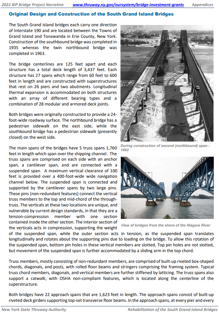
North: (Bridge Hunter broke Mar 22, 2023; Historic BridgesSatellite, 179 photos)
South: (Bridge Hunter broke Mar 22, 2023; Historic Bridges; Satellite, 279 photos)

"Smaller than the bridges at the south end of the island, these bridges are part of the same projects, and one of these two bridges was built in 1935 and the other in 1963, and are nearly identical." [HistoricBridges_North]

NiagaraFallsInfo has the northern bridges longer than the southern bridges at 4,000' (1,219m) vs. 3,400' (1,036m). It also specifies a completion date of 1962 for the southern bridge and 1965 for the northern bridge.

"The appearance of built-up members containing v-lacing and lattice on the [northbound] 1963 bridge suggests that this was an intentional decision to make it blend in with the 1935 bridge. Most 1963 bridges would not feature v-lacing and lattice on so many members.... V-lacing on many of the members of the 1963 span features 'railroad style' v-lacing, which was a heavier design that riveted each bar that formed the v-lacing separately of the other. The 1935 bridge in contrast features the more standard v-lacing which used one rivet to attach two v-lacing bars to each side of the beam." [HistoricBridges_South]


Looking North at the South Bridge
Street View, Aug 2017

Looking West at the South Bridge:
Street View, Aug 2017

Looking North at the North Bridge:
Street View, Jun 2022
 
Andy Ligammari posted
One bridge, two lanes, 1966. "Going to Beaver Island" Probably ten or fifteen cent tolls. Remember the coupon books? The halcyon days.
Jim Myers shared

1 of 3 photos posted by Amy Daggett
𝗧𝗛𝗘 𝗢𝗡𝗘 𝗧𝗛𝗔𝗧 𝗚𝗢𝗧 𝗔𝗪𝗔𝗬(𝗼𝗿 𝘄𝗼𝘂𝗹𝗱𝗻'𝘁 𝗹𝗲𝗮𝘃𝗲)
Last night when crew from NEW YORK with her barge DOUBLE SKIN 509A said they would be done dispatching their load of asphalt soon and planned to pull out first thing in the morning, we did what all obsessed Ship Junkies would do. We scampered home to bed so we could get up early to catch it because this was a unique opportunity for a couple of reasons
First, these vessels  have a special story. In 2020, Vane Brothers which is headquartered in Baltimore Maryland expanded their fleet to service the Great Lakes with this this tug barge combination. The double-hull tank barge utilizes a sophisticated thermal heating system that keeps asphalt at approximately 300 degrees Fahrenheit so that the highly viscous liquid remains relatively thin and flows more easily.
Next, the route they would take leaving the Niagara River takes them through the the Black Rock Channel and the Black Rock Lock. This provides safe passage for vessels between Buffalo Harbor and Tonawanda Harbor around the rapids that exist in the upstream portion of the Niagara River. The present Lock, which was constructed by the Corps of Engineers from 1908-1913, can accommodate large Great Lakes vessels with a lock chamber that is 650 feet (200 m) long, 70 feet (21 m) wide, and rises 6 feet according to canals.ny.gov with an actual lift time of 12-15 minutes.
There are also bridges along the channel. The Ferry Street Bridge was constructed in 1913. It is a bascule bridge, a kind of lift bridge, built by the Strauss Bascule Bridge Company, and is considered a rare and historic design. Seeing this bridge lift is a unique opportunity. 
But alas, it wasn't meant to be. We woke to steady rain but forged ahead. We mapped our route in preparation and timed the transit between our viewing location to be certain we wouldn't miss the bascule bridge. When the skies cleared we have a little cheer and went to see if they were getting ready to move. Our excitement was squelched when we told the Lock was closed due to wind and their departure was delayed until tomorrow morning 😭
What did you think Ship Junkies? Do I make my retired husband go back tomorrow to try again 🤔

PD Cappola posted

LC-DIG-highsm- 52618 (ONLINE) [P&P]
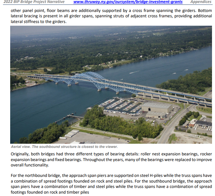
Aerial view of the twin spans of the South Grand Island Bridge, which cross the Niagara River in five sky-blue steel arches (four of them below road level), north of Buffalo, New York
Credit line: West Virginia Collection within the Carol M. Highsmith Archive, Library of Congress, Prints and Photographs Division.
Carol M. Highsmith's photographs are in the public domain.
 
James Cavanaugh Photography posted
From my Archive. A 2005 view of the east branch of the Niagara River looking NE towards the Tonawandas with the south Grand Island Bridges in the foreground.
Jim Cavanaugh shared
[same comment]

Neil Ferguson posted two photos with the comment: "Buffalo's newest pedestrian bridge has arrived on-site at Ralph Wilson Park near downtown Buffalo, NY. The pedestrian bridge was fabricated in Italy, then shipped across the Atlantic, up the Hudson, and along the full length of the Erie Canal. On Friday [Jul 19, 2024?] night it docked on the Erie Canal in Tonawanda, NY before making the final leg of the journey down the Niagara River on Saturday Morning." [The south bridges]
1

2

1935 V-lacing:
Street View, May 2023

The V-lacing on both bridges looks the same to me. The vertical member uses "railroad lacing," but that was true on the other bridge as well.
1965 V-lacing:
Street View, May 2023

KwikBondPolymers
The new decks for the four bridges "utilized a Polyester Polymer Concrete Overlay." The deck replacement was done during 2010-2017.
 
South Bridge:
AmericanBridge_south, Photo by Brianna82
Total length: 3,437'
Longest span: 600'

North Bridge:
AmericanBridge_north, Photo by Brianna82
Total length: 4,038'
Longest span: 400'


Thruway, p3

Deborah Brown posted two photos with the comment: "Good Evening Buffalorians 🚶🏽‍♀️ Ongoing construction of the  South Grand Island Bridge northbound 1961, 2nd photo SouthGrand Island Bridge today 🚧"
Jim Myers shared
1

2

Andy Parker posted
Tonight's sunset over the South Grand Island Bridge. Taken by Dave Vogan Photography.

WGRZ - Channel 2, Buffalo posted two photos with the comment: "From Traffic Tracker 2’s Dave Cash: A stranded motorist blocks the right lane on the 190 North before the top of the South Grand Island Bridge - traffic is bumper to bumper & backed up on the 190 North & on the 290 West."
1

2

Adam Rudnick posted
 
NYC Thruway Authority posted
🌉 NEWS: A $1.6 million federal grant will allow the Thruway Authority to conduct a Planning and Environmental Linkages (PEL) study of the Grand Island Bridges. The aim is to develop the framework for the future maintenance, rehabilitation and potential reconstruction of the structures. Read more ➡️ https://www.thruway.ny.gov/.../2024-08-14-gib-grant... Mike Kaminski shared

Robert Preskop posted two photos with the comment: "The South Grand Island bridges spanning the east channel of the Niagara River in Tonawanda New York."
1

2

Monday, August 7, 2023

1995 TX-146 (Fred Hartman) Bridge over Houston Ship Channel at Baytown, TX


Patrick Feller Flickr, License: Creative Commons Attribution (CC BY)
Fred Hartman Bridge, Baytown, Texas 1209261519
 
John Weeks
This bridge replaced a tunnel that was removed when the channel was deepened to 45' (13.7m).
"The Hartman Bridge is huge any way you look at it. Another bridge that compares is the Arthur Ravenel Jr. Bridge in Charleston, South Carolina. Both bridges are about the same length, about the same main span, and both carry 8 lanes of traffic. While the Ravenel bridge solved this problem with a single span that carries all 8 lanes, the Hartman bridge has two spans of 4 lanes each. This lead to the Hartman bridge having 4 towers rather than two, and nearly double the number of stay cables. A secondary result of having more stay cables is that they towers did not need to be nearly as tall. In fact, the towers on the Hartman bridge are nearly 100 feet shorter than the Ravenel bridge.
"The Fred Hartman Bridge suffered from a characteristic that many cable stay bridges have, and that is vibration in the cables that starts during a light rain. These vibrations have lead to over 100 welds failing on the structure. A solution using dampening cables was installed, which as largely solved the problem. The bridge has since been inspected and repaired."

Carol caught the bridge when dampening ties were added.
LC-DIG-highsm- 18764 (ONLINE) [P&P], 2012 October
Credit line: West Virginia Collection within the Carol M. Highsmith Archive, Library of Congress, Prints and Photographs Division.
Carol M. Highsmith's photographs are in the public domain.

Highway Engineering Discoveries posted
Highway Engineering Discoveries posted again
Puente Fred Hartman Bridge
 
Bill Baumgartner commented on the second post by Highway Engineering Discoveries
 
Highway Engineering Discoveries posted
Fred Hartman Bridge
Cable-stayed bridge in Houston, Texas
HED posted

TexasCapital
"The bridge was constructed in 1985 and cost $91 million to build. It stands 440 [124m] feet tall and stretches 2.6 miles [4.2km] long. At the time of its construction, it was the longest cable-stayed bridge in the world."
[The article provides the years 1989, 1992 and 1995 for the completion. The actual facts are that the construction started in 1986 and finished in 1995.]
The span is 2,800' (0.5 mile, 853m), and the deck is supported by 448 cables. The main span is over 1,200" (.23 mile, 366m) It has a clearance of 178' (54m).
"The bridge was named after Fred Hartman, a renowned newspaper editor and publisher who was instrumental in its construction."

wbctx
"At 436 feet [133m] high, the bridge features a fan arranged cable stay arrangement and provides a vertical clearance of 262 feet." It agrees with the cost of $91m. It disagrees with the vertical clearance of 178'. I think the 262' specification is wrong.

This source puts the clearance at 178' and the cost at $117m. And this source agrees with 178' and $117m.
 
aecom
"Today, it is one of the world’s most well-known cable-stayed bridges, accommodating 200,000 vehicles per day. AECOM developed the unique, award-winning double-diamond towers that stand as tall as a 45 story building yet efficiently resist hurricane winds. The cable-stayed main span unit is 2,475 feet long [450m] – the length of eight football fields – and allows eight lanes of traffic to smoothly flow 175 feet over the Houston Ship Channel."

This shows another solution for cable ties to dampen the vibrations in the main cables.
1:40 video @ 1:15

I tried to use street view to find more views of the cable ties. But I couldn't find any. So what is the current solution for dampening the vibrations of the stay cables? I also could not find any cable ties in the 3D satellite views.
Street View, May 2023

There were a lot of street views. The oldest one does show the cable ties. They disappeared between Jun 2013 and Jul 2015.
Street View, Mar 2008