(
Satellite, a comment suggested the Palos area with the moraine in the background. Unfortunately, I don't know where the moraine is. I do notice there is a
Moraine Valley Community College.)
The Chicago Sanitary & Ship Canal that opened in 1900 reversed the flow of the Chicago River. In 1922, the original Cal Sag Channel was dug to reverse the flow of the Calumet Rivers. Also, the sanitary district's first
water treatment plant was built. [
encyclopedia.chicago] The equipment to get material up and out of the channel had changed significantly since the CS&SC construction. Note the block of
dolostone that the right "crane" is removing. This 60' channel was widened in the 1960s. (I'm still looking for info on the widening.)
There are many more photos of the construction in
1922 Blue Island Lock
 |
MWRD posted on Apr 4, 2022
Workers begin to assemble a dredge during early phases of construction for the Cal-Sag Channel on December 6, 1911.
MWRD posted again |
 |
MWRD posted
Excavation for the Cal-Sag Channel in Section 2 (of 14) on July 3, 1912. Section 2 is 1.3 miles in length and runs through Lemont and Palos Township and was built between October 1911 and October 1915. Construction of the 16-mile-long channel was divided into 14 sections and was completed in 1922. |
 |
MWRD
Workers and drills during excavation for the Calumet Saganashkee (Cal Sag) Channel on September 3, 1912. The 16-mile channel was built by the MWRD between 1911 and 1922.
MWRD posted on Jun 16, 2023 |
 |
MWRD posted on Sep 1, 2022
Excavation for the Cal-Sag Channel on July 3, 1912. The 16-mile Cal-Sag Channel was built by the MWRD between 1911 and 1922.
MWRD posted again |
 |
MWRD posted
Workers retrieving a steam shovel out of the mud near the Cal-Sag Channel on December 31, 1912. Soft, wet clays in the Chicago area caused problems during construction of the channel and frequent slope failures often resulted in additional excavation work.
Pete Ostrowski: I am always amazed at the size of the timbers that were readily available at the zenith of the second industrial revolution. The trees that held that wood must have been magnificent. |
 |
MWRD posted on Mar 28, 2022
Construction of the Cal-Sag Channel on July 6, 1916. |
 |
MWRD posted on May 29, 2022
Construction of the Cal-Sag Channel in Blue Island, Illinois, on September 20, 1916. |
 |
MWRD posted on Nov 8, 2022
Construction of the Cal Sag Channel in Blue Island, Illinois, on September 20, 1916. |
 |
MWERD posted
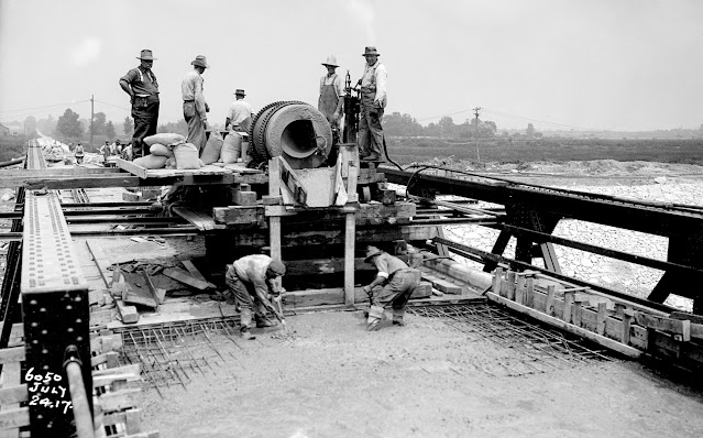
A concrete mixing station for construction of the Cal-Sag Channel and railway bridges near Lemont, Illinois, on November 30, 1916. |
 |
MWRD posted on Jul 28, 2022
Construction of the Cal Sag Channel in an area near Blue Island, Illinois, on December 6, 1916. |
 |
MWRD posted
Construction of a section of the Cal-Sag Channel in Blue Island, Illinois, on December 6, 1916. |
 |
MWRD posted on Sep 20, 2022
Excavation for the Calumet-Saganashkee Channel in Lemont Township on March 28, 1917.
MWRD posted |
 |
MWRD posted
Construction of the Cal Sag Channel on April 20, 1917. The Sanitary District of Chicago (now MWRD) built the 16-mile long channel between 1911 and 1922.
Kevin Coyote-Trust Does MWRD know roughly where the pic was taken?
Joseph Obrien Looks like the Palos area with the moraine in the background.
MWRD posted on Sep 24, 2022
Construction of the Cal-Sag Channel on April 20, 1917. |
 |
MWRD posted
Construction of the Cal-Sag Channel east of Ashland Avenue in the City of Blue Island Illinois on May 3, 1917. The 16-mile-long channel was built by the MWRD between 1911 and 1922. |
 |
MWRD posted
A view to the west from a bridge at Ashland Avenue in Blue Island during construction of the Cal-Sag Channel on May 3, 1917. |
 |
MWRD posted
Construction of the Cal Sag Channel on April 20, 1917. The 16-mile long channel was built by the MWRD between 1911 and 1922 and connects to the Little Calumet River on the east and the Chicago Sanitary and Ship Canal on the west.
Stephen Casper: 4 blocks from my house. It was widened around 1955. A bike trail now runs along side of it.
MWRD posted on Mar 27, 2023 |
 |
MWRD posted
Removal of spoil during construction of a section of the Sanitary District's Cal-Sag intercepting sewer system near the intersection of Indiana Avenue and 120th Street in Chicago on July 27, 1917. |
 |
MWRD posted
Work near the confluence of the Cal-Sag Channel and the Chicago Sanitary and Ship Canal in Lemont, Illinois, on May 12, 1919. The 16-mile-long Cal-Sag Channel was built by the MWRD between 1911 and 1922. |
 |
Marc Worst commented on the above post
This is one of the Steam Shoves at the Chicago Sanitary and Ship Canal in the 1890s. |
 |
MWRD posted on Aug 9, 2022
Construction of the Cal-Sag Channel near Blue Island, Illinois, on September 8, 1919. The channel was completed 100 years ago in 1922. |
 |
MWRD posted
Construction of the Cal-Sag Channel looking west from the south channel wall showing a side view of the Ann Street bridge abutments and forms for the Stony Creek outfall in Blue Island, Illinois, on May 5, 1920. |
 |
MWRD posted
Construction of the Cal-Sag Channel in City of Blue Island Illinois on September 16, 1920, viewed looking east towards Stony Creek and the Ann Street and Western Avenue bridges, showing A. Guthrie & Co. Inc casting concrete channel walls which were later removed when the channel was widened between 1955 and 1965.
Deanna Stark: Friend of mine, long dead, knew one of the (if not the only) guys who ran the gigantic bridge crane that travelled down the edges of the canal as they dredged the material, stone to one side, and dirt to the other, as they worked westward. Good example of the stockpiles they created was in Crestwood. They mined it for crushed stone the last few years…. |
 |
MWRD posted on Nov 28, 2021
Construction of the Cal-Sag Channel near Blue Island, Illinois, on January 28, 1921, looking to the east showing a view of the Stony Creek outfall and Ann Street bridge.
MWRD posted on May 24, 2023
MWRD posted |
 |
MWRD posted
The Cal-Sag Channel under construction in Blue Island on April 19, 1921, viewed from the south channel wall showing the Stony Creek outfall and the Ann Street bridge with a concrete conveyor tower at the north end of the bridge. |
 |
MWRD posted on Mar 3, 2022
Construction of the Cal-Sag Channel on April 21, 1922. |
 |
MWRD posted
Construction of the Cal-Sag Channel on May 22, 1922. |
 |
MWRD posted on Mar 9, 2022
Construction of the Cal-Sag Channel on July 12, 1922. |
 |
MWRD posted
Construction of the Cal-Sag Channel on July 12, 1922, in an area near the Village of Worth. |
 |
MWRD posted
Construction of the Cal Sag Channel in Blue Island, Illinois, on June 4, 1917, looking SW from the Chicago, Rock Island and Pacific Railroad showing the Western Ave Bridge.
MWRD posted |
 |
MWRD posted on Jan 12, 2022
Construction of the Cal-Sag Channel in Blue Island, Illinois, near Stony Creek on May 19, 1921. The 16-mile channel was built by the MWRD between 1911 and 1922. |
 |
MWRD posted on Apr 20, 2023
Construction of the Cal-Sag Channel in Blue Island, Illinois, on May 19, 1921, near Stony Creek. The 16-mile channel was built by the MWRD between 1911 and 1922. |
 |
MWRD posted
Construction of the Cal-Sag Channel in an area near Stoney Creek on June 20, 1921.
Ken Lovati: Looks like they used a type of slip form . Very cool history . |
 |
PatCamallierBooks, Courtesy of MWRD
[This was the drainage ditch through the Sag Valley that was widened into the 60' Cal Sag Channel.] |
 |
MWRD posted
Workers and a concrete mixer during the construction of the Cal-Sag Channel on September 8, 1915, viewed to the southwest in an area between La Grange Road and Route 83.
MWRD posted again on Oct 13, 2022 |
 |
MWRD posted on Aug 27, 2022
Workers help to position a moveable concrete form during the construction of the Cal-Sag Channel on September 8, 1915, viewed to the southwest in an area between La Grange Road and Route 83.
MWRD posted
MWRD posted |
 |
MWRD posted on Dec 22, 2022
Construction of the Cal-Sag Channel on September 8, 1915, viewed looking east in an area between La Grange Road and Route 83. |
 |
MWRD posted
Excavation for the Cal-Sag Channel on January 3, 1914. The Sanitary District of Chicago, now MWRD, built the 16-mile long channel from 1911 until 1922.
MWRD posted on Mar 18, 2023 |
 |
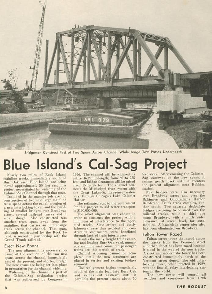
One of 39 images posted by Michael Siola, at Facebook resolution (source)
Part of a $190m project authorized by Congress in 1946. The 16.2-mile channel was widened from 60' to 225' and the bridge clearances were raised from 15' to 25'. |
 |
MWRD posted
Construction of the Cal-Sag Channel on October 5, 1914. |
 |
MWRD posted
Construction of the Cal-Sag Channel on October 5, 1914. |
 |
MWRD posted on Apr 26, 2022
Construction of the Cal Sag Channel on October 6, 1914.
MWRD posted |
 |
MWRD posted on May 7, 2022
Construction of the Cal Sag Channel on October 6, 1914. |
 |
MWRD posted on Oct 4, 2022
Construction of the Cal-Sag Channel on October 6, 1914.
MWRD posted again |
 |
MWRD posted on Dec 12, 2022
Construction of the Cal Sag Channel on October 6, 1914.
MWRD posted |
 |
MWRD posted on May 20, 2022
Construction of the Cal-Sag Channel on December 6, 1916. |
 |
MWRD posted
Construction of the Cal-Sag Channel near Blue Island on December 6, 1916. |
 |
MWRD posted
Construction of a bridge at Piper Road (now Ridgeland Avenue) over the under-construction Cal-Sag Channel in Worth, Illinois, on July 24, 1917. The 16-mile Cal-Sag Channel was completed 100 years ago this year, with construction beginning in 1911 and ending in 1922. |
 |
MWRD posted on Sep 13, 2022
Today's photo shows a dragline cleaning an area near the Cal-Sag Channel on August 24, 1922.
MWRD posted |
 |
MWRD posted on Sep 16, 2022
Today’s historical photo shows workers and stone crushing machinery next to a spoil pile along the Calumet-Saganashkee Channel near Blue Island on October 2, 1922. |
 |
Mike Girdwain commented on MWRD's post
Cal-Sag Channel view from Swallow Cliff, Palos Park, 1920's.
Mike Girdwain: Fresh pilings from excavation on the banks. |
MWRD
posted 3 images with the comment:
For immediate release
September 27, 2022
Cal-Sag Channel, Calumet Water Reclamation Plant turn 100
MWRD engineering achievements reversed flow of Calumet River system and introduced wastewater treatment to protect public health and water quality
Within the span of a month in 1922, the Metropolitan Water Reclamation District of Greater Chicago (MWRD) -- then known as the Sanitary District of Chicago -- completed two monumental engineering feats to protect the health of the region and local water quality. A century later, the Calumet Water Reclamation Plant (WRP), Cal-Sag Channel, and reversal of the Calumet River system remain as pillars supporting public health and regional water environment.
The MWRD will mark this occasion at its
10th Annual Sustainability Summit to be held at the Ford Calumet Environmental Center, 11555 S. Stony Island Ave. in Chicago, on Friday, Oct. 21 at 10 a.m. The 100th Anniversary of the Calumet Water Reclamation Plant (WRP) and Cal-Sag Channel will be highlighted among several presentations, a photo exhibit and discussion. Members of the MWRD’s first Community Partnership Council will be announced to promote community engagement within the communities the Calumet WRP serves. For more information on the Sustainability Summit, visit
https://mwrd.org/10th-annual-sustainability-summit.
After 11 years of construction, the gates at the Blue Island Lock on the Little Calumet River were opened on Aug. 18, 1922, diverting water to flow into the new Cal-Sag Channel for the first time. By Aug. 26, the Cal-Sag was fully operational. This action began the process to allow the MWRD to reverse the flow of the Little Calumet River west away from Lake Michigan, protecting the supply of drinking water and providing integral drainage to shelter and enhance the Far South Side.
A few weeks later on Sept. 11, 1922, the MWRD completed construction of the Calumet WRP, 400 E. 130th St., Chicago. The new facility implemented emerging treatment technology that could transform wastewater from across the area into clean water.
Today, the Calumet WRP is the longest-tenured MWRD water reclamation plant, serving more than 970,000 people each day from Chicago and 48 surrounding suburbs and providing around-the-clock services. The Calumet WRP can treat up to 450 million gallons of water each day, generating renewable energy and recovering vital resources to protect the planet and taxpayers. In addition to building the plant and digging the 16-mile Cal-Sag Channel, the MWRD built 6 other WRPs and nearly 184 miles of intercepting sewers to convey water from municipal sewers to its treatment plants.
“This September we recognized 100 years of service, innovation and ingenuity at our Calumet Water Reclamation Plant and the work of our predecessors to construct the Cal-Sag Channel,” said MWRD President Kari K. Steele. “These measures that we often take for granted have had a profound impact on our way of life and today bolster our homes and businesses and keep our water environment safe.”
The MWRD reversed the Chicago River through the construction of the Chicago Sanitary and Ship Canal (1900) and reversed the North Branch of the Chicago River through the construction of North Shore Channel (1910). But as the rest of the Chicago River reversed, the Calumet River was still flowing out to Lake Michigan, causing concern for waterborne illness and polluted water flowing out to the source of the region’s drinking water in Lake Michigan. Like the Sanitary and Ship Canal, the MWRD discovered the Calumet River system could also flow west by building a new canal that allowed gravity to funnel water through the subcontinental divide away from the Great Lakes toward the Mississippi River Basin.
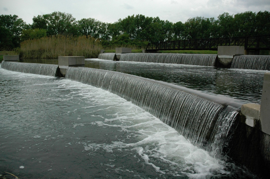
The 16-mile Cal-Sag Channel continues serving as the link to keep water flowing west, connecting the Calumet River system to the Chicago Sanitary and Ship Canal and downstream to the Des Plaines River, Illinois River and Mississippi River to the Gulf of Mexico. Today it is a thriving waterway attracting a surging population of fish, birds and recreation, and its construction generated a boom of economic opportunity, helping establish towns and attract residents, commerce and community life.
“We celebrate the work of those before us who introduced transformative environmental protections which lead to recreational opportunities, industrial growth, and community and economic development throughout the region,” said MWRD Commissioner Kimberly du Buclet. “Our region has come a long way and we are still pursuing an even better quality of life for the residents that live and work here.”
The introduction of wastewater treatment at the Calumet Water Reclamation Plant (top left and right) and Cal-Sag Channel (bottom left and right) proved critical to protecting the Chicago area’s public health and its environment altered the landscape of the region and established Chicago and the Southland region as a thriving metropolis destined for economic vibrance.
 |
| 1 |
 |
| 2 |
 |
| 3 |